Showing posts with label condemned cottages. Show all posts

Thursday, June 16, 2016

Condemned in Vicksburg, Mississippi

On May 28, a short article in the Vicksburg Post listed six houses that would be razed. The article (quoted below) said these would be the first houses demolished since 2014. I took a quick trip around town to check on the properties and record them before they were gone and forgotten. I have also included photographs of other houses torn down recently.
No. 2511 Cedar Street is a cottage at the corner of Military Ave. and Cedar Street. Part of the building suffered a fire.
The inside was a mess with papers strewn about and an abandoned mattress.
Bridge Street is one of Vicksburg's oldest neighborhoods. It is on a hill just north of the Kansas City Southern railroad cut and south of the hill that one held a water tank, now replaced with a cell tower. Most of the cottages appear to be late-1800s. No. 809 was a cottage made of concrete blocks cast in the form of limestone blocks. The vines were taking over. I spoke to the lady who lived to the left, and she complained about the jungle infringing on her lot.
The inside was a mess, there had been a fire, and some of the roof collapsed. Note the beautiful fireplace tiles. These should be recycled. And notice the lath under the plaster walls. As of June 14, the house is gone.
This is an example of the concrete blocks with a rough texture pattern like limestone. Note that this was hand-mixed concrete that used rounded river rock in the aggregate.
On the lot to the right (east), the cheerful yellow wood house at 815 Bridge burned in 2013 and was torn down.
Heading northeast, 605 Howard Street is a bit hard to find, at the junction of Howard and East Main Streets. This is another example of a condemned house where the former inhabitants may have left in a hurry, leaving possessions behind.
The inside looked reasonably intact.
No. 1633 Jackson Street was a trailer. These are common in the county but rare within the city limits.
Next door, 1617 Jackson Street was almost covered with vines but was not on the demolish list in the Vicksburg Post article.
This is a 2012 photograph of Jackson Street looking west with the cottage at 1617 on the right, not yet engulfed by vines.
Stouts Bayou crosses under Jackson Street here, passing through a 1920-vintage brick arch. Much of the riverbed in the bayou needs cleaning and re-concreting, but the City has been unable (or unwilling) to obtain right-of-way for access.
Jumping back to 2014, this was a derelict store at 2728 Drummond, also right next to Stouts Bayou.
In 2015, an old house at 1520 Marcus Street burned. It is another historic Vicksburg neighborhood that has lost numerous houses in the last 15 years.
This church has been at 906 Yazoo Street for many years.
This is the same church in 1996 (from an Agfa Scala slide taken with a Leica M3 camera). This neighborhood is south of Army-Navy Drive, beyond the City of Vicksburg's shops and garages. Many of the houses have been demolished and there simply are fewer residents in this area than there were decades ago.
No. 840 Buck Street is also gone. This is a 2010 photograph taken on Kodak Panatomic-X film with a Fuji GW690II camera.
As I wrote in a previous article, all these cottages on Marys Alley have been demolished. They were in a flood zone and were inundated whenever the Mississippi River rose above approx. 47 ft on the Vicksburg gauge. This is also Panatomic-X film.
No. 1412 Jackson Street was a nice Victorian cottage in another one of Vicksburg's historical neighborhoods.
Finally, I did find one 2015 demolition in my photographs. This was a brick-fronted cottage at 816 Walnut Street. My friends and I saw the tractor at work on a Sunday when we rode by on bicycles.

Among the recent group of demolitions listed in the Post, I missed the house at 1216 Fayette Street before it was razed.

The 2012 and 2016 photographs were taken with a Fuji X-E1 digital camera; the older black and white photographs on film. A few others were from a Nexus 4 phone.


Board votes to raze six buildings
Published 10:27 pm Friday, May 27, 2016

Six vacant and derelict buildings in the city will soon be going down.


The Board of Mayor and Aldermen Wednesday approved contracts with two construction companies totaling $23,150 to raze the houses, which city officials have said are a threat to the health and safety of their neighborhoods.


“All of these houses have been approved by the board for demolition,” said Community Development Director Victor Gray-Lewis.


The six buildings, at 605 Howard St., 1633 Jackson St., 809 Bridge Street, 2511 Cedar St., 906 Yazoo St. and 1216 Fayette Street, are the first to be taken down since 2014.


The board has been hiring private contractors for several years to raze houses targeted by the city for demolition. The companies submit bids on the projects and the lowest bids for each project are selected.


The city at one time used public works employees to take the structures down, and charged property owners a fee based on a combination of the employees’ hourly rate and the cost of using the equipment. The equipment charge was based on a fee scale used by the Federal Emergency Management Agency to reimburse local governments for using equipment to clean up after disasters.


The practice stopped because of an increase of project involving city infrastructure.

Sunday, January 10, 2016

Decay within sight of the State Capitol, Jackson, Mississippi

I have always been surprised how a run-down neighborhood can be only a few blocks away from a major commercial or government area. I first encountered this in Houston, where slum houses in the Fourth Ward had a view of the glamorous glass office buildings of downtown. I had not encountered this type of urban disparity in European or New England cities. Jackson fits the pattern: just west of the state capitol, slum neighborhoods are rough and being abandoned or torched.
George Street is (or was) a mess. I have not been back since I took these photographs in 2011, and many of these shotgun shacks have likely been demolished.
East Church Street, a block north of George street, was just as dilapidated. This is a photographer friend checking an abandoned house.
These were once nice residential neighborhoods. Unfortunately, I am not surprised they were allowed to decay. Jackson is in rough shape, and you readers know many of the reasons (I won't list them because this is not a political blog). When the houses are razed, the property no longer serves as a tax source. Less tax revenue means city services, infrastructure, and schools deteriorate, which leads to more people abandoning their properties and moving to more prosperous communities. The blight spirals - the race to the bottom that we see in so many American cities. It is absolutely disgusting.

Photographs taken on Kodak Panatomic-X film with a Fuji GW690II rangefinder camera (the "Texas Leica"). I developed the film in Agfa Rodinal developer at 1:50 dilution and scanned the negatives with a Minolta Dimage Scan Multi medium format scanner.

Friday, June 20, 2014

South Nags Head - the Condemned Beach Houses that Never Collapse

Dear Readers, some of you may remember my previous articles about the elevated cottages at East Seagull Drive in South Nags Head, North Carolina. They were condemned when they were in danger of collapsing into the Atlantic Ocean. Well, to confound the skeptics, they are still standing as a testament to convoluted U.S. real estate laws and property rights, and are serving as a rather macabre tourist attraction.
An odd feature: one of the houses has been reinforced with secondary new pilings, and there is a real estate sign underneath. Have the houses been un-condemned?
The northernmost house in the group is leaning rather ominously. Is this one for sale, too?

Let's move to  a more cheerful topic: one of the largest sand dunes on the east coast. This is Jockey's Ridge State Park. The high, unvegetated area of Jockey's Ridge is known as a medano—a massive, asymmetrical, shifting hill of sand lacking vegetation. (El Médano, in Spanish, is "the sand dune," as well as the name of a town on Tenerife.) According to the state park web page, "Jockey's Ridge is the tallest active sand dune system in the Eastern United States, and the most striking of the remaining dunes on the Outer Banks. Shifting winds are constantly reshaping the dunes. Because the Ridge is always changing, it is often referred to as "The Living Dune.""
It is really interesting to walk to the top and see the Atlantic ocean to the east and Albemarle Sound to the west. You can pretend for a few minutes that you are doing the Lawrence of Arabia march through the desert, except there are no camels.
When it rains, a sizable pond forms in a hollow to the east of the main part of the dune, demonstrating that barrier islands can have a high ground-water table if there is sufficient regular rainfall.
A popular activity is to slide/jump down the steep east side, sort of like running down a snow field. Well worth a visit!

Click the links for the 2010 article on the condemned houses. The 2012 article described the houses and the beach nourishment project.

Photographs taken with Fujifilm X-E1 and Panasonic G3 digital cameras.

Tuesday, March 18, 2014

More Pearl Street Cottages, Vicksburg, Mississippi: 2014

Long-term readers may remember my 2010 essay on cottages of Pearl Street, Vicksburg. A notice in the Vicksburg Post about a house that had been condemned inspired me to revisit Pearl Street. The news is bad: many houses have been razed, and many of the remaining are in poor condition. This once-vibrant community is simply crumbling away.  Let's start at the north and work our way south, with house numbers increasing. This is a long article with plenty of houses to cover. You will see recent photographs along with scans of Kodachrome slides from the 1980s and 1990s.
The railroad has always run parallel to Pearl Street, at least since the Civil War. This is the main line to Jackson. The 2005 photograph is from the new embankment, which cuts across land once owned by Vicksburg Lumber Company. The railroad bought it to reduce the radius of the curve as the trains turn east to go under the Washington Street tunnel.
2000 Pearl Street, 2004 (Kodachrome slide).
The first house on our tour is No. 2000.  This is the west side of the street, where the land drops off steeply down to the railroad yard a few hundred meters further west.  Therefore, the rear of most of these west houses are supported on stilts.

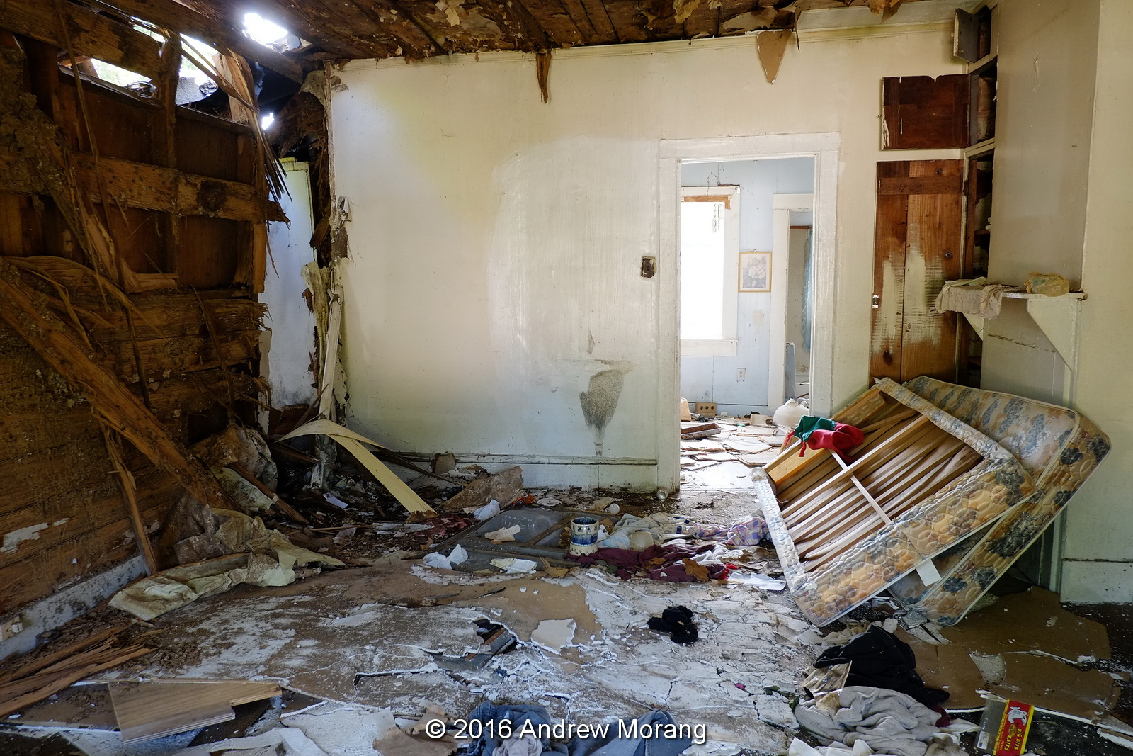
The little house at 2004 was condemned, according to a January 7 article in the Vicksburg Post. The City had been unable to locate the owner, and the inspector deemed it a hazard. Notice in the third photograph, the far wall beyond the door has been totally eaten by termites. By February 22 (2014), the house was gone.This is how we have lost so much housing over the last two to three decades: the place deteriorates, the owner is gone and cannot be located, and the city is forced to raze the unit and take ownership of the parcel. Then the property no longer generates tax revenue.
Next on our tour is this house at 2014. As of February 2014, it was still standing.
This is no. 2114, with an awning and asphalt siding shingles. This house also was standing in 2014.
No. 2118 is occupied and in fair condition.
2123 Pearl Street
A bit further south on the east (opposite) side of the tracks is 2123. It is empty, status unknown.
This big mansion is at 500 Klein Street. It was once a tour home but may be for sale now.
Also on the east side, a set of small cottages. This is No. 2213.
The little yellow shotgun is No. 2215.
No. 2217 is almost identical, except for the porch having siding.
The last of the group is No. 2219.  All of these were occupied as of February, 2014.

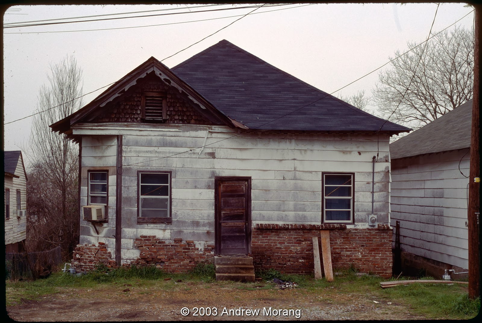
Moving on to the 2300 block, this little store was at 2328 Pearl. Now it is a dull brown paint and unused.
Located across the street from 2328, this pink unit at 2410 may have also been a store. As I recall, it has been empty for years but is in reasonable condition. It is interesting to consider that there were once enough residents to support two neighborhood groceries.
 No. 2414 is a cottage, occupied in 2003.
No. 2416 had a home-made brick half facade.
No. 2418 was in poor condition in 2003, and is gone now.
No. 2420 was a duplex. I think it is also gone now.
Up on the east side was no. 2421, in poor condition in 2003, and demolished soon after.
The next house on the east side, 2423, was also in poor condition in 2003.  It, too, is gone.
Back on the west side, no. 2424 was painted and sound.
No. 2426 was a cheerful little place with a couch out front.
No. 2428 was another blue house (at least in 2003). Notice that in the 1993 photograph above, it was pink.
The house at 2430 was the last on the west side of the tracks. Further south (to the left in the photograph), the land drops off steeply. Possibly years ago there were more houses on stilts, but I do not remember them.
These were my basketball buddies from 2002. I wonder where they live now?
This yellow house at 2504 is unusual in that it is made of cinder-block. It is empty now.
No. 2508 was on the west side and was condemned as of 2003.
Across the street on the east side was No. 2509, one of many cottages formerly on the hillside.
Just a bit south, no. 2521 soldiers on, usually in rather rough shape. Several other houses nearby have been demolished, ones that I did not photograph.
No. 2529 and a matching unit next are still occupied.
This is no. 2531, almost identical to the former.
This is no. 3513 up on a hill. In 2006, when I took the photograph, it had just been repainted and fixed..
The small cottage at no. 3607 is the last house on this Pearl Street tour.

So many of the houses have been demolished, it is hard to tell exactly where they once stood. The lots are covered with grass or brush. To think, once this was a vibrant mixed neighborhood with hundreds of residents, but is rapidly depopulating. This is the fate of so many small American towns.

I took most 1980s and 1990s frames on Kodachrome 25 film with a Leica M3 camera and the 50 mm ƒ/2.8 Elmar lens (the post WWII version with lanthanum glass). The 2014 images are digital files from a Fujifilm X-E1 digital camera.