Friday, July 22, 2016

Travels on the Mother Road, Route 66 - Part 2, Central California

We continue our tour on the Mother Road, Route 66. Once you leave the Los Angeles valley and rise out of Cayon Pass on Interstate 15, you are in the Mojave Desert. The towns along I-15 still have the ubiquitous California urban sprawl, but there is undeveloped desert between them.
Route 66 is also known as the National Trails Highway in central California. About 15 miles from Cajon Pass, the National Trails Highway diverges north away from I-15 at Victorville. Drive north a few miles and you reach Oro Grande. There is not much to downtown Oro Grande other than an old-fashioned business block, but it contained an active restaurant and a couple of gift shops.
Salvaged & Tattered, at 19248 National Trails Highway, was open. Songs by Edith Piaf emerged from the door - what, Piaf in the desert of California? Interesting place; the charming proprietor graciously let me take a photograph in her store. She said many Europeans stopped at the store, and a surprising number did the trip both directions. They rented a car in Chicago, drove to Santa Monica, and then turned around and drove back on 66. She said she had also met Europeans who bought a high-horsepower American muscle car, did the 66 trip both directions, and then shipped their car home as a used car. Some people do interesting things....
Just north of Oro Grande, I passed a field with some old cars. By chance, a fellow was at the gate waiting for someone to let him in. The lady who came to the gate said I was welcome to photograph this handsome Hudson Statesman Custom. Her uncle or dad(?) was restoring it - one day. They really made massive cars in the 1940s.
A few miles further northeast, near Lenwood, I came across the abandoned Dunes Motel, at 23135 Main Street. The palms really needed pruning. Many odd birds lived in the foliage. I watched for snakes because I was wearing sandals.
I doubt anyone will ever use the Dunes again. Possibly it had been modified to serve as apartment units.

The National Trails Highway turns east, running north of I-15. We enter Barstow, which was a major mining and transportation center starting in the 1800s. It was on the Old Spanish Trail from Santa Fe as well as the Mormon Road from Salt Lake City. Barstow became a major rail center for the Santa Fe railroad as well as a stopover for Route 66 travelers.
And who could resist stopping at the famous ElRancho Motel? The signs tell you how far it is to various popular cities, including Cairo and Jerusalem (Route 66 goes that far?). A tenant who spoke to me emphasized that Marilyn Monroe stayed there.
Downtown Barstow is rather uninspiring, despite many attempts to link contemporary stores with Route 66.
The Route 66 Mother Road Museum is located in the historic Barstow Harvey House hotel. The hotel has been restored and is used for formal events and graduations. The National Park Service has a description of the Harvey House and other sites along Route 66. Amtrak's Southwest Chief train stops here. My daughter took the Chief from Chicago to Los Angeles many years ago but may have slept through Barstow.
The Western America Railroad Museum is next to the depot. Unfortunately, you can't go into the locomotives, but there is still plenty to see.

We will continue our Mother Road expedition in future updates. Please stay tuned and thanks for reading. These photographs are from a Fuji X-E1 digital camera with the in-camera monochrome setting. I used a polarizing filter on many exposures to emphasize the dark sky.

Friday, July 15, 2016

Travels on the Mother Road, Route 66 - Part I, Los Angeles Area

Background

Dear Readers, this is the first of a series of articles on Route 66, also known as the Mother Road. This was not the first paved road across America, but when it officially opened on November 11, 1926, it consolidated numerous existing highways into one identifiable path extending from Chicago, Illinois, to Los Angeles (and later, Santa Monica), California. During its heyday in the 1950s and 1960s, mobile and post-war-wealthy families, dreamers, and wanderers explored the route, supporting thousands of restaurants, motels, gas stations, and roadside attractions through eight states and 2,400 miles of "Main Street of America." Most guidebooks start the journey in Chicago and describe the trip heading westward. But I drove Route 66 eastward from Los Angeles as far as Albuquerque, so I will organize these posts in a series of stages moving from west to east.

Recommended reading:  Route 66 Adventure Handbook by Drew Knowles (Santa Monica Press).
GPS waypoints: GPS waypoint files are available at Route66maps.com. You can load them into your Garmin device and it will display a heart-shaped icon when you approach a historical Route 66 feature.
Legends of America has a lot of good online information and a state-by-state guide.

Ron Maskell, an Australian, did an amazing bicycle ride on most of Route 66 in 2012. His blog is a readable resource with excellent photography, and he has interesting observations about Americans from from a non-US viewpoint. Some quotes from his summary page were sobering:
Route 66 does not run through the pretty parts of America. 
The roads between the towns often went through areas of severe rural poverty, lonely country, desolate country and towns that were either deprived, were looking extinction in the face or have died already.
Of the survivors, the older neighbourhoods were run-down and neglected, some almost derelict. Along the interstates, which are the scrub ticks draining the life from these towns, motel, Wal-Mart and service station development seems poorly planned and opportunistic. My impression was that the lack of government or official support is killing off Route 66. Many businesses are either struggling or closed down. 
A 2009 article in Smithsonian (March 2009, Volume 39, No. 12) titled 10 Must-See Endangered Cultural Treasures, included Route 66 as one of these treasures.

The Route 66 Corridor Preservation Program, administered by the National Park Service, is attempting to restore and preserve many of the cultural artifacts. "It's a tremendous cross section of American history along those 2,400 miles," says Barthuli (program administrator). "If we lose those stories, we're really losing a sense of ourselves."

Los Angeles Area, California

Route 66 once extended into downtown Los Angeles via Figueroa Street and, in later years, continued to Santa Monica via Santa Monica Boulevard or Sunset. But the metropolitan sprawl of modern Los Angeles has gobbled up most (all?) traces of the old Route 66. There are plenty of dumpy buildings in Los Angeles that may date to the Route 66 era, but a visitor would be hard pressed to make much of a connection. I recommend you skip trying to find remnants of 66 in downtown Los Angeles and proceed east.

But moving east is equally frustrating because Pasadena, Arcadia, Monrovia, San Dimas, and Glendora have also suffered from extreme urban sprawl. 66 is essentially gone. But starting in Glendora, the map shows Route 66 proceeding along historic Foothill Boulevard. Well, the first few miles are solid modern strip with malls, gas stations, and condominium complexes. The waypoints on my Garmin GPS showed features along the way, but all were gone, overrun by modern malls and concrete.
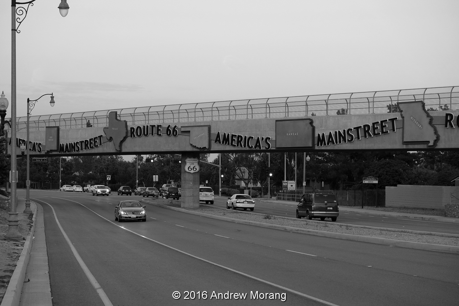
Finally, as your enter Rancho Cucamonga, a handsome bridge announces that you are on Route 66. Well that is hopeful. And to the left (north), the historic Sycamore Inn still serves fine food. But the urban sprawl continues and there is little 66 memorabilia to see for the next few miles until you reach Rancho Cucamonda.
Continue along Foothill Blvd. It is pretty dull, but when it rains, the water gushes along the pavement. It reminds me of Houston.
Finally, something interesting, the Wigwam Motel. Each concrete teepee is an individual motel unit, and all looked immaculately clean.
A friendly Indian lady (from India, not native American) graciously let me take photographs. She said she and her family had run the motel for 13 years.
There were some period Route 66 vehicles on the property, a theme that I was to see all along the route.
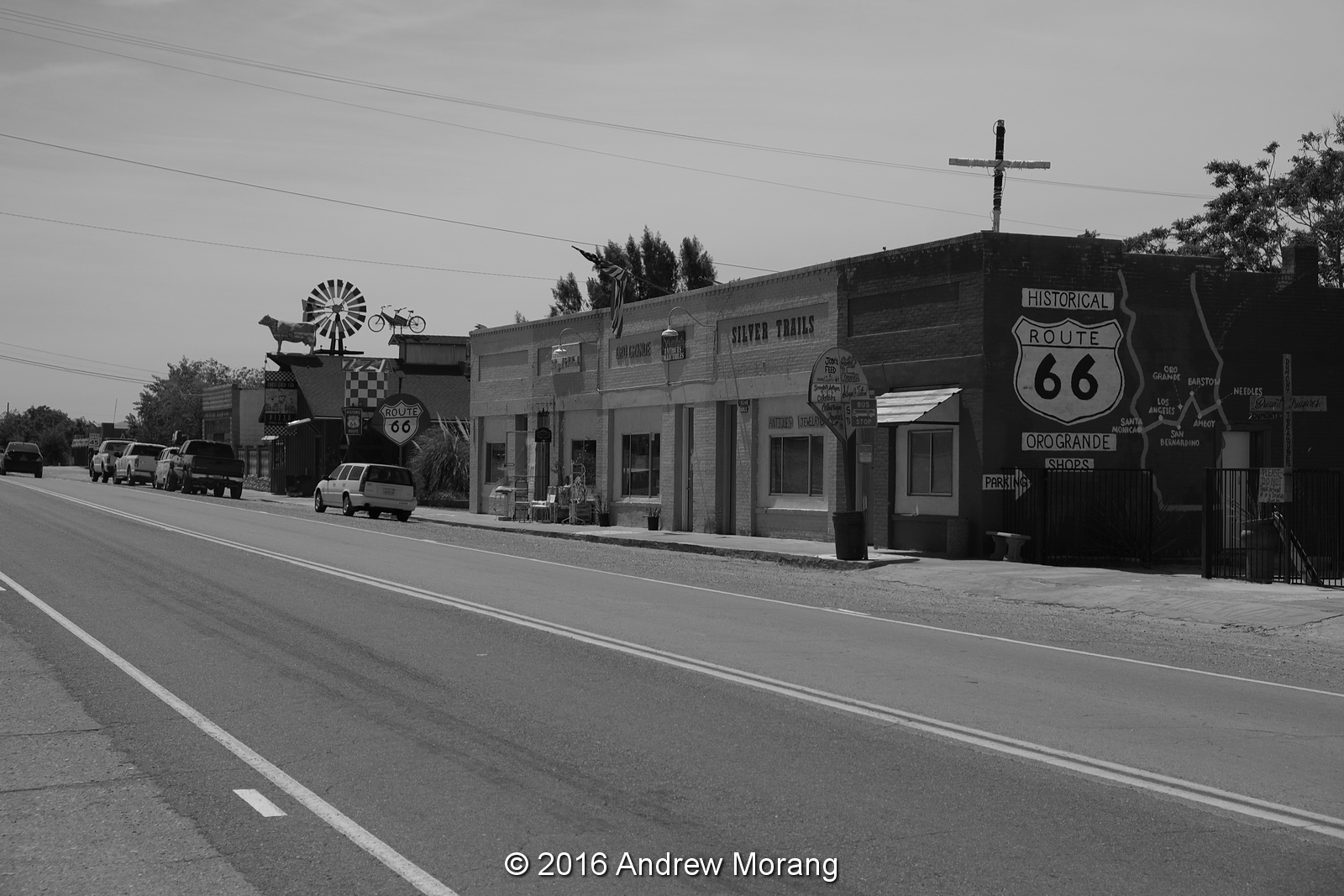
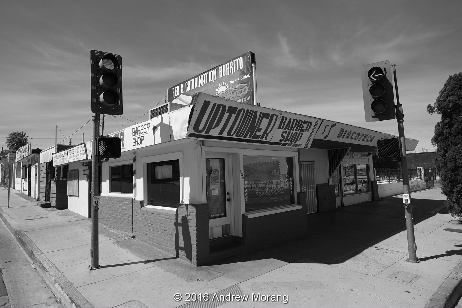
San Bernardino is reputed to be a pretty rough town, but compared to many places I have visited, it is not too bad. Route 66 bypasses downtown and turns north on Mt. Vernon Avenue.
There is a large Hispanic community in San Bernardino with numerous churches to serve them.
The former Lido Motel at 2140 Cajon Blvd. is now rented as apartments. They looked reasonably clean and a couple of residents help me find the original Route 66. Notice the square boxes on the roofs. These are swamp coolers, which are evaporative coolers, where the cooling occurs via the evaporation of water.

Ascending the narrow Cajon Pass is difficult because parts of 66 have been overridden by the modern Interstate 15 (I-15). But once over the pass, we are in the desert and we can continue to look for Route 66 remains (to be continued).

Photographs taken with a Fuji X-E1 digital camera. I set it on black and white mode to fit the 1950s ambience of my expedition. I reprocessed some RAW files with PhotoNinja software. (Note, click any photograph to expand it to 1600 pixels wide.)

Monday, July 4, 2016

Burmese Days 21: NaPyar, the Odoriferous Fish Village

While driving from Rangoon eastwards towards the Golden Rock, our driver took us along a short stretch of the Yangon-Mandalay Highway, then turned right on the Maylamyaing Highway (NH8).

Historical note: the Yangon-Mandalay highway was originally surveyed and laid out by an American engineering company, Louis Berger & Associates, in 1961, under the sponsorship of the U.S. Army Corps of Engineers (Moorhus and Grathwol, 1992). Initially, conditions seemed to be in place for construction bids to be let, but planning and economic assistance for the project ended in 1963, a victim of deteriorating domestic politics in Burma and worsening relations between the United States and Burmese government. The expressway was finally built by the Burmese between 2005 and 2010, with some funds generated by exporting natural gas to Thailand.
At Waw Village, we stopped for a rail crossing. The train trundles along at a leisure pace because of the rough condition of the track bed. We could see the cars swaying back and forth, I suppose likely to generate cases of mal de mer (or mal de chemin de fer?).
A short distance east of Waw, our driver stopped at NaPyar Village. This is low terrain, crisscrossed by canals and rivers. It reminded me of southern Louisiana. On the barge just off the bank, piles of fish were drying in the sun.
The aromatic dry fish are neatly piled on tables at roadside stands. In the photograph above, the leaves are used to wrap betel nut (chewed by ladies and gents alike).
The lady even uses a pole with hook to neatly organize the fish curls on hooks.
I was impressed by the amount of business these stands attracted. Maybe the Vicksburg farmers' market needs a dried fish stand.
This sturdy gent was mashing up fish remnants in a giant pestle. Afterwards, the mush was poured into a clay pot, sealed, and left to ferment for an unknown amount of time. The resulting fish sauce (juice) was sold in gallon-size glass jugs at the roadside stands. Think of this the next time you buy oriental fish sauce at the supermarket.

Photographs taken with a Fuji X-E1 digital camera.

References
Moorhus, D.M. and Grathwol, R.P. 1992. Bricks, Sand, and Marble: U.S. Army Corps of Engineers Construction in the Mediterranean and Middle East, 1947-1991. Washington DC: US Government Printing Office, 660 p. (available online, http://www.history.army.mil/html/books/bricks_sand_and_marble/CMH_45-2-1.pdf)

Blogger note:
I am trying to overcome the problem with photographs not uploading into the blog. Based on suggestions from other bloggers around the world, I removed all the EXIF data from the photographs. For now, the photographs are all appearing, but there is still some issue with the Google servers because for five years, all jpeg files uploaded successfully.

Wednesday, June 29, 2016

Blogger is Temporarily Sick - Now is OK again

Dear Readers,

Blogger is ill. No, not me, I'm fine other than being old. But the servers that serve the blog articles are failing to upload some of the photographs. It may have something to do with Google's migrating their Picasa Web Albums to Google Photos. The photographs that you see in these posts are stored in Picasa Web Albums, up to 2000 photos per album. But when I open my albums, I see that some photographs no longer appear but have a placeholder instead with a small question mark (?) in a box. Google is, hopefully, working on the problem. In the meantime, sorry for the inconvenience.

July 9 update: By removing the copyright symbol © from the EXIF data in each photograph, the photograph will upload and display properly. I have been re-uploading photographs from some of my older posts. 

July 21 update: All photographs appear again. Google did some change to their software, and photographs with odd characters in the EXIF fields display properly, just as they did before.

Saturday, June 25, 2016

Burmese Days 20: The Golden Rock of Kyaiktiyo

One of the pilgrimage sites of profound importance to Buddhists is the Kyaiktiyo Pagoda (Burmese: ကျိုက်ထီးရိုးဘုရား) in Mon State of southeast Burma. Most westerners know it as the Golden Rock because the actual pagoda is a small structure perched on the top of a granite boulder. The boulder has been covered with layers of gold leaf over hundreds of years by devotees, and it glows gold in the setting sun. According to legends, the Golden Rock itself is perched on a strand of the Buddha's hair, and indeed, the rock is said to rock very slightly. Considering that Burma is in an earthquake zone, I can't understand why it has not rolled down from its precarious perch.

The lower photograph is half of a stereo frame from Wikimedia Commons, "Kyaitteyo Pagoda, miraculously balanced by a hair of Buddha, on Kelasa hills, Burma", Date: 1900, Author:  Underwood and Underwood (in the public domain).
The rock and the pagoda are at the top of Mt. Kyaiktiyo. To reach the mountain, you drive to the town of Kin Pun Sakhan and board a lorry which has been outfitted with benchseats in the bed. Then the lorry grinds up the Golden Rock Mountain Road in caravan with other lorries. Much of the road is single-lane, so the lorries wait at sidings for other trucks going the other way. Finally, you reach the plateau area and disembark. The first impression is not very auspicious - sheds for the trucks, vendors of food and souvenirs, trash. Hmmm...
The vendors sell some strange food. Centipedes? Fish and cakes of unknown grain(?) or protein(?).

The upper reaches are accessed by steps after you pay an entry fee. Two large lions guard the entrance to Kyaiktiyo Pagoda, and from here on, you must be barefoot, which was difficult for my wife.
Families camp up on the marble platform. We met some adorable children. They look healthy, intelligent, and alert.
Monks discuss and smoke.
Models pose for photographers. This is an interesting place; like the Swedagon in Rangoon, almost a merger of religious site and country fair.
At dawn, families wait for the sun to cast on the Golden Rock.
Pilgrams donate food and lay it out neatly along the railing next to the rock. It makes quite a mess, and I am not sure if the food is for monks or if it is cleaned up and discarded daily.
Looking north, you can see that the entire mountain top is covered with restaurants and guesthouses. I think these are mostly for Burmese visitors, while Western tourists stay in a couple of hotels on the south side. We stayed at the Mountain Top Hotel, which was decent and had rooms with private bath. The setting with view to the east was sublime.
Finally the ride back downhill in the lorry, squashed in with as many people as they can fit. Truly, the Golden Rock is unique, and if you visit Burma, take a side trip to Kyaiktiyo. It takes about 4 or 5 hours to drive from Rangoon, and you need to charter a car and driver and pay for hotel and food. But just do it.

Photographs taken with a Fuji X-E1 digital camera, Nexus 4 phone, and on Tri-X film with a Leica M2 camera.

Thursday, June 16, 2016

Condemned in Vicksburg, Mississippi

On May 28, a short article in the Vicksburg Post listed six houses that would be razed. The article (quoted below) said these would be the first houses demolished since 2014. I took a quick trip around town to check on the properties and record them before they were gone and forgotten. I have also included photographs of other houses torn down recently.
No. 2511 Cedar Street is a cottage at the corner of Military Ave. and Cedar Street. Part of the building suffered a fire.
The inside was a mess with papers strewn about and an abandoned mattress.
Bridge Street is one of Vicksburg's oldest neighborhoods. It is on a hill just north of the Kansas City Southern railroad cut and south of the hill that one held a water tank, now replaced with a cell tower. Most of the cottages appear to be late-1800s. No. 809 was a cottage made of concrete blocks cast in the form of limestone blocks. The vines were taking over. I spoke to the lady who lived to the left, and she complained about the jungle infringing on her lot.
The inside was a mess, there had been a fire, and some of the roof collapsed. Note the beautiful fireplace tiles. These should be recycled. And notice the lath under the plaster walls. As of June 14, the house is gone.
This is an example of the concrete blocks with a rough texture pattern like limestone. Note that this was hand-mixed concrete that used rounded river rock in the aggregate.
On the lot to the right (east), the cheerful yellow wood house at 815 Bridge burned in 2013 and was torn down.
Heading northeast, 605 Howard Street is a bit hard to find, at the junction of Howard and East Main Streets. This is another example of a condemned house where the former inhabitants may have left in a hurry, leaving possessions behind.
The inside looked reasonably intact.
No. 1633 Jackson Street was a trailer. These are common in the county but rare within the city limits.
Next door, 1617 Jackson Street was almost covered with vines but was not on the demolish list in the Vicksburg Post article.
This is a 2012 photograph of Jackson Street looking west with the cottage at 1617 on the right, not yet engulfed by vines.
Stouts Bayou crosses under Jackson Street here, passing through a 1920-vintage brick arch. Much of the riverbed in the bayou needs cleaning and re-concreting, but the City has been unable (or unwilling) to obtain right-of-way for access.
Jumping back to 2014, this was a derelict store at 2728 Drummond, also right next to Stouts Bayou.
In 2015, an old house at 1520 Marcus Street burned. It is another historic Vicksburg neighborhood that has lost numerous houses in the last 15 years.
This church has been at 906 Yazoo Street for many years.
This is the same church in 1996 (from an Agfa Scala slide taken with a Leica M3 camera). This neighborhood is south of Army-Navy Drive, beyond the City of Vicksburg's shops and garages. Many of the houses have been demolished and there simply are fewer residents in this area than there were decades ago.
No. 840 Buck Street is also gone. This is a 2010 photograph taken on Kodak Panatomic-X film with a Fuji GW690II camera.
As I wrote in a previous article, all these cottages on Marys Alley have been demolished. They were in a flood zone and were inundated whenever the Mississippi River rose above approx. 47 ft on the Vicksburg gauge. This is also Panatomic-X film.
No. 1412 Jackson Street was a nice Victorian cottage in another one of Vicksburg's historical neighborhoods.
Finally, I did find one 2015 demolition in my photographs. This was a brick-fronted cottage at 816 Walnut Street. My friends and I saw the tractor at work on a Sunday when we rode by on bicycles.

Among the recent group of demolitions listed in the Post, I missed the house at 1216 Fayette Street before it was razed.

The 2012 and 2016 photographs were taken with a Fuji X-E1 digital camera; the older black and white photographs on film. A few others were from a Nexus 4 phone.


Board votes to raze six buildings
Published 10:27 pm Friday, May 27, 2016

Six vacant and derelict buildings in the city will soon be going down.


The Board of Mayor and Aldermen Wednesday approved contracts with two construction companies totaling $23,150 to raze the houses, which city officials have said are a threat to the health and safety of their neighborhoods.


“All of these houses have been approved by the board for demolition,” said Community Development Director Victor Gray-Lewis.


The six buildings, at 605 Howard St., 1633 Jackson St., 809 Bridge Street, 2511 Cedar St., 906 Yazoo St. and 1216 Fayette Street, are the first to be taken down since 2014.


The board has been hiring private contractors for several years to raze houses targeted by the city for demolition. The companies submit bids on the projects and the lowest bids for each project are selected.


The city at one time used public works employees to take the structures down, and charged property owners a fee based on a combination of the employees’ hourly rate and the cost of using the equipment. The equipment charge was based on a fee scale used by the Federal Emergency Management Agency to reimburse local governments for using equipment to clean up after disasters.


The practice stopped because of an increase of project involving city infrastructure.