Sunday, July 31, 2022

Panoramas on the Dixie Overland Highway - Mound, Tallulah, and Delhi (XPan 04)

As I wrote in the previous article, a generous friend loaned me his fabulous Hasselblad XPan panoramic camera. You may recall that I wrote about using an XPan in western Washington and Seattle during 2004, when I worked there for a few months. 

This offer was much too kind to resist. Loading a roll of Kodak Tri-X 400 film, I crossed the Mississippi River bridge to Louisiana and drove west on historic US 80, once known as the Dixie Overland Highway. I have photographed in Mound and Tallulah before with regular cameras, but the area offers topics for a wide view. Please click any picture to enlarge it. Unenlarged, they look like skinny sideways pictures, especially on a mobile phone.  (An aside: one day I plan to follow the former route of the Dixie Overland all the way to San Diego.)

Delta


Mount Zion BC Church, near Delta, Louisiana (45mm lens, med. yellow filter)

Tallulah


Tallulah is a bit beat-up. I have photographed there over the years and sometimes bicycle through town if I bike the loop on LA 602 and US 80. 

No shopping here, West Green Street (US 80), Tallulah (45mm, med. yellow filter)
No shopping here, either, West Green Street
Waiting for a load, West Green at Fourth Street (45mm at ƒ/8, yellow filter)
Fixer-upper house west of Tallulah, US 80
Willow Bayou Rice & Grain, west of Tallulah, US 80

Delhi


Delhi (Del'-high) is an agricultural town west of Tallulah on US 80 (no, not the Delhi in India - I have been there, too). It looks a bit more prosperous than Tallulah, and the downtown strip has some stores and restaurants.

Mooney's Auto Sales & Repairs, First Street (US 80) at Rundell Street, Delhi
No more pumping, Delhi Water Works
The Air Man of Delhi, First Street (US 80)

I took these photographs on Kodak Tri-X 400 film exposed at EI=320. Northeast Photographic in Bath, Maine, developed the film. Because the frames are 68mm wide, I scanned them in two pieces of 36mm with my Plustek 7600i film scanner and merged them with the Photomerge function in Photoshop CS5. The Tri-X is a bit grainy and does not let these lenses show their true potential.

Thanks, Bill, for letting me use your XPan!

Standby for more Xpan photographs in the future, including examples in color.

Sunday, July 24, 2022

Hasselblad XPan Panoramic Camera: How to Handle the Film? (XPan 03)

Hasselblad XPan camera with 30mm, 45mm, and 90mm lenses
XPan with 30mm ƒ/5.6 lens and special viewfinder
Center filter on 30mm ƒ/5.6 lens


The amazing hardware


A friend in town generously loaned me his fabulous Hasselblad XPan camera with its three unique lenses. The Hasselblad XPan (and the identical Fuji TX-1) were innovative cameras that used regular 35mm film to create a negative that was 24×65 mm in size rather than the usual 24×36 mm frame common in most 35mm cameras. 

For me, the wide frame was a revelation. Through the viewfinder, I could see topics that I might have skipped with a normal camera or would have found boring without the wide frame to show the context of the scene. The wide frame provides a narrative to the main topic. I will post a series of XPan articles in the next few months. 

A recent guest author on Casual Photophile also wrote about how the wide view gave him a new way of viewing his world. An author on 35MMC found his XPan to be his favorite travel camera. But Hamish Gill of 35MMC found that the XPan just did not suit his type of photography enough to keep the valuable camera. It is a specialist tool to be sure.

However, this camera's wide frames require different handling than normal 35mm negatives. I did not see much on the internet about how people process or scan this unusual 24×65 mm frame. This article will describe my procedure.*


XPan negatives (converted to positive). Oh, oh, what to do with the odd shape?

Optical enlarging


If you print in a darkroom optically, any medium format or 4×5" enlarger like a Beseler would be suitable for the XPan negatives. I was surprised to see that Beseler still sells an XPan film holder. It is rather expensive at B&H, but at least is available. 

Years ago, some commercial labs developed XPan negatives and printed 4×12 inch machine prints. Nice. I have some albums with pages just for this size.


4×12 inch prints in plastic album. Lake Union, Seattle, Washington

Some companies made plastic print booklets specifically for the 4×12 prints.

Scanning options


Most people today probably scan the negatives and then post the results on the web or make ink jet prints. But how to scan these odd-size negatives? Some options:

  1. Use a digital camera with macro lens and a copy stand to take a picture of the negative, and then reverse with software. My friend who owns the XPan uses this technique. 
  2. Scan the negatives on a medium format scanner. My Minolta Scan Multi will fit the 65mm length, but I would need to cut a 24×65 mm mask. Minolta may have once sold a frame and mask in this size, but I doubt I could ever find one. Nikon's medium format scanners could be used for Xpan negatives. They used to sell a glass negative carrier that came with a mask for the Xpan format. It worked but was clumsy and very slow. 
  3. Scan left and right frames of 24×36 mm in a regular 35mm film scanner and then combine them with software. I used this method with my Plustek 7600i scanner and then merge the two pieces with Photoshop CS6 (details below). 
  4. Commercial scanning. Some laboratories may offer this service via the Imacon Flextight scanner (alas, no longer available new and staggeringly expensive)

Digital camera scanning


Monument Valley Navajo Tribal Park, Arizona. © Bill Stripling
Acueducto de Segovia, Segovia, Spain. © Bill Stripling
French Pyrenees. © Bill Stripling

This is Method 1 above. These are all scans made with a Nikon Z7 camera and reversed in Lightroom with Negative Lab Pro software. To my eye, these results look fantastic. If you have a high-resolution digital camera, this is an excellent technique. The quality of the light source is important if you are scanning color negatives. For LED sources, the spectrum needs to be as smooth as possible. Gaps or spikes in the spectrum can cause color shifts. 

Merging 24×36 mm scans


Plustek 7600i scanner with 35mm negative holder. Note how one XPan frame overlaps into the second opening.

I use Method 3, where I scan left and right sections of the XPan negative sequentially. For the two frames to blend properly, there must be some overlap (possibly 10-20%). You need to set the exposure and color balance for one of the frames and then be sure to not change those settings for the second frame. What I do:
  1. Preview the left or right section in a 24×36 mm frame (i.e., the full size for this scanner).
  2. Adjust color, gain, and contrast as needed.
  3. Make a final scan at 3600 dpi and save as a 16-bit (full color) TIFF file.
  4. Remove the film holder, pull the XPan frame so that the other side is in the 24×36 opening.
  5. Reinsert the holder in the scanner but leave gain and color unchanged. This means I cannot preview this second piece.
  6. Make a final TIFF scan of this second section.
  7. If needed, clean scratches and chemical blobs with the heal tool in Photoshop.

Assembly


It sounds confusing but is relatively simple. Then I use the >Automate>Photomerge tool in Photoshop CS5 or CS6 to combine the two sections. Make a final check if the wide frame needs some cropping and you are done. It is a bit time-consuming but works well. 

Below is an example from the rail line south of the Amtrak Station in Jackson, Mississippi and one from a junk yard in Edwards.


Pascagoula Street overpass left frame


Pascagoula Street overpass right frame


Final panorama from Pascagoula Street overpass (Kodak Portra 160 film)

I-20 junk yard left frame


Junk yard right frame


Final panorama, I-20 North Frontage Road, Edwards (Portra 160 film, 45mm ƒ/4 lens at ƒ/5.6½)

Despite the work, this Xpan is a lot of fun and an amazing creative tool. Standby for more examples. Thank you, Bill, for letting me use your camera.


* I am not going to use the term "workflow." That is a cliche on photography web pages, especially the infamous DPreview. "I returned from my weekend in Paris and did my special workflow to my 15,000 shots." Bleech.


Sunday, July 17, 2022

Back When it was Cool: Charles River, Boston, January 1968

Winter of 1968


With the summer midday heat here in Vicksburg hovering around 34° or 35° C (95° F), one thinks of cool. In my stuff (of which there is far too much), I found some Kodachrome slides of the frozen Charles River in Boston. I took these in January of 1968, when I did not know anything about photography but was excited by views and vistas. My grandmother was visiting (the lady from my Escape from Berlin article), and we went to the Top of the Hub observation deck in the Prudential Tower. I can't recall if we ate lunch up there. 

Charles River view west with Cambridge across the river
Charles River view northeast towards Charlestown with Longfellow Bridge in the center

The handsome multi-arch bridge is the Longfellow Bridge, built in 1901. A friend remembered how badly rusted the steelwork had become some 20 years ago. The structure received an almost total rebuild in the early 2000s. Beyond the Longfellow bridge is the Charles River Dam, on which is located Boston's Museum of Science.

Back Bay in foreground with the Charles Basin and MIT campus across the river

Decades ago, I taught sailing in the Charles Basin at Community Boating. This public sailing organization has run programs for adults and children here since 1946. Summer was lazy and laid-back. We filled baggies with water and threw them at other boats. During those sailing days, I sometimes walked across town to Durgin Park Restaurant for a cup of chow-dah and a 95 cent luncheon. Then home via the MBTA on Dime-Time (yes, only 10 cents).

In autumn, the winds picked up and the fun increased. If a boat went over, a motor boat came out to pick us up and right the capsized sail boat. Then they took us to a doctor in Back Bay who administered tetanus shots. There was none of that get permission from your parents stuff - you got a tetanus shot. How times have changed. 

But best of all, the Charles River has been drastically cleaned. Once a national scandal for its pollution, the river now hosts fish, eagles and other wildlife. This is a dramatic example of the benefits of federal waterway protections by means of the EPA's Charles River Initiative.

Topographic Notes


Let us step back into topographic history. Much of the flat land area today in Boston is artificial land fill. We often use the term "reclamation," as if we are reclaiming the land from the sea or river, waging battle on the evil forces of nature. 


Landfilling in Boston since 1630 has more than doubled the urban area (unfortunately, at the expense of destroying what must have been highly productive wetlands). The figure above is adapted from Rosen, Brenninkmeyer, and Maybury (1993).

The Charles River Basin and the neighborhood that you see in the snowy pictures above is artificial. The tidal river between Boston and Cambridge was formerly an expanse of mudflats which were exposed twice daily and renowned for mosquitoes and nasty aromas in summer. The original 1910 dam converted the basin into an agreeable fresh-water body, along which fashionable homes, a landscaped esplanade, and institutions of higher learning were located (Whitehill 1968). 


Museum of Science on original Charles River Dam

Little of the original dam can be seen because a busy highway crosses it and the Museum of Science was built on the dam in 1950. 

New Charles River Dam and pump house, completed in 1978

The new Charles River Dam is multi-function project. Not only was it designed to protect against unusually high tide or surge in Boston Harbor moving upstream into the basin but also to maintain a restricted range of water level in the Charles River Basin. Large pumps can pump rainwater and runoff from the river side of the dam out into the harbor side (on the left in the photograph). The pumps first operated during the Northeast Blizzard of '78. 

Back Bay in 1944, before construction of the Prudential Tower

The Back Bay has been Boston's most fashionable neighborhood since the marsh ands tidal flats along the original Charles River were drained and filled, with construction starting in 1859. From Wikipedia:
Setback requirements and other restrictions, written into the lot deeds of the newly filled Back Bay, produced harmonious rows of dignified three- and four-story residential brownstones (though most along Newbury Street are now in commercial use). The Back Bay is listed on the National Register of Historic Places, and is considered one of the best-preserved examples of 19th-century urban architecture in the United States. In 1966, the Massachusetts Legislature, "to safeguard the heritage of the city of Boston by preventing the despoliation" of the Back Bay, created the Back Bay Architectural District to regulate exterior changes to Back Bay buildings.
My wife's mother and parents lived in the Back Bay before World War II, but I do not know the address. If you worked in downtown Boston, this would be elegant and convenient.

Visit Boston, walk in the Back Bay, admire the fashionable and expensive stores, lunch at a bistro, have your hair done at a spa, and consider how history surrounds you.

References

Rosen, P. S., Brenninkmeyer, B. M., and Maybury, L. M. 1993. “Holocene Evolution of Boston Inner Harbor, Massachusetts,” Journal of Coastal Research, Vol 9, No. 2, pp 363-377.

Whitehill, W.M.  1968.  Boston, A Topographical History.  Second edition, enlarged, Belknap Press of Harvard University Press, Cambridge, MA, 299 p.


The snow pictures are from Kodachrome II film, probably taken with my dad's Canon rangefinder camera (unknown model) and its 50mm ƒ/1.9 Canon Serenar lens. My dad's 1944 Kodachrome is from a Perfex camera (unknown model).

Sunday, July 10, 2022

The Great New England Hurricane of 1938

Background


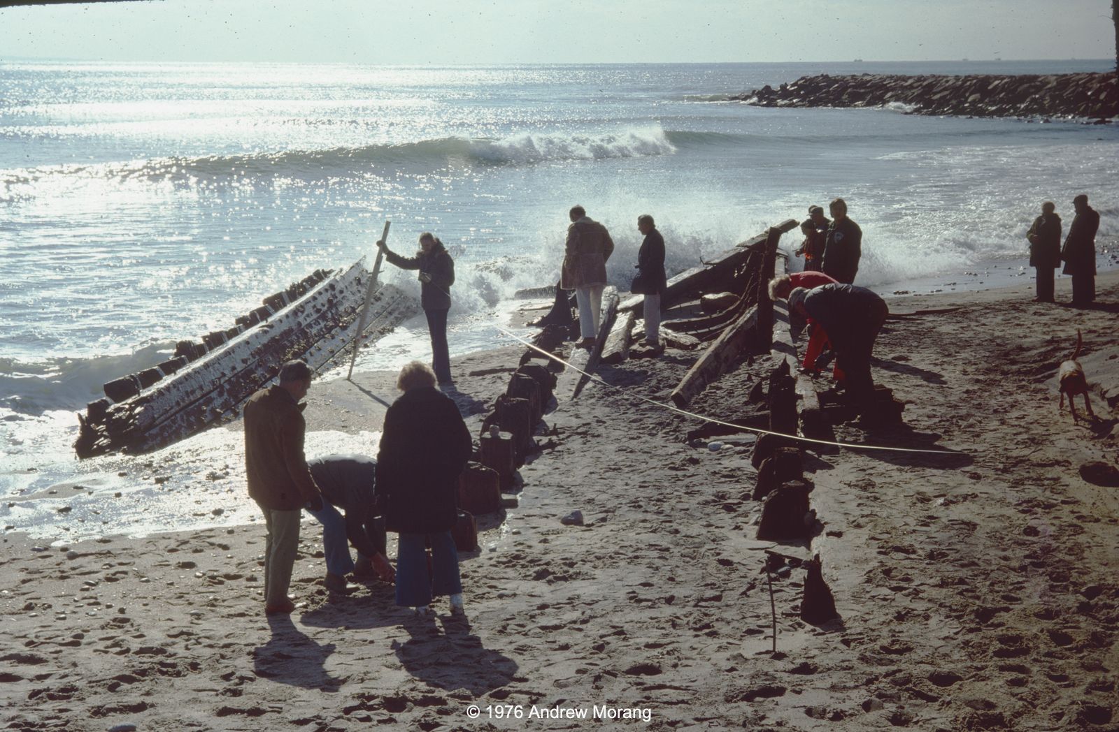
In the previous article, I showed some photographs of beaches on southern Rhode Island. One included chimney remains in the surf zone, remnants from before 1938, when the "Long Island Express" roared ashore in Long Island and devastated coastal communities throughout southern New England. It is an interesting topic. 

For background on the great storm, an episode of American Experience, titled "The Hurricane of '38" is fascinating viewing. The transcript is also available online. Below is an excerpt from my paper in Journal of Coastal Research. The text is long, so feel free to skim. The map below shows the tracks of some of the most destructive hurricanes to pass over New England. 

Most powerful New England hurricanes. Locations from NOAA. Background map from ESRI Data and Maps   

John Winthrop of Massachusetts Bay Colony and William Bradford of Plymouth described the 1635 hurricane in their diaries. NOAA recreated the approximate path with modern modeling techniques. Ludlum (1963) in Early American Hurricanes provides more details of The Great Colonial Hurricane. 

Pawtuxet Village, 1938
"General destruction in the upper harbor. Workboat floated up on land by stormsurge. New England Hurricane of 1938"

Source:

Collection Location: Other 
Photo Date: 1938 September 22 
Credit: Donated by Susan Medyn, Tiverton, Rhode Island   


September 1938 Hurricane


The Great New England Hurricane of September 21, 1938, was one of the seminal meteorological events in New England's 20th century history.  The storm caused unprecedented damage throughout New England and Long Island, killed over 600 people, and devastated coastal communities along the open Atlantic shore, Long Island Sound, Block Island Sound, Narragansett Bay, and Buzzards Bay (Allen, 1976; Federal Writers' Project, 1938; Minsinger, 1988).  On Long Island alone, the death toll was 60. The damage was beyond anything that 20th century northeast residents had ever experienced or recorded.  Throughout New York and New England, the wind and water felled 275 million trees, seriously damaged more than 200,000 buildings, knocked trains off their tracks, and beached thousands of boats (Haberstroh, 1998).  Wind and rain damage extended as far north as Rutland, Vermont, entire city blocks burned in New London and other industrial towns, and downtown Providence, Hartford, and other cities flooded.

Various writers estimated damage from the storm at $600 million in 1938 dollars.  Pielke and Landsea (1998) estimated damage of $306 million for the affected coastal counties.  They recalculated the loss to be $16.6 billion in 1995 dollars by normalizing the damage by inflation, personal property increases, and coastal county population changes.  Therefore, if we double their base damage estimate to $600 million to include inland counties that experienced flooding, the normalization to 1995 dollars might be in the range of $32 billion.  Based on the Consumer Price Index (CPI) inflation calculator (Bureau of Labor Statistics, 2014), this equates to $50 billion in 2014 dollars.  In comparison, Hurricane Sandy in October, 2012, caused ≈ $18.75 billion in insured property losses, excluding flood claims covered by the Federal flood insurance program (Insurance Information Institute, 2013).

The 1938 storm was first detected as a tropical depression off the Cape Verde Islands.  On September 15, east of Puerto Rico, it was upgraded to a hurricane.  Florida residents began to make preparations, but by the 20th, the system curved northward towards the Carolinas.  A low pressure trough moving out of the Great Lakes had enough strength to steer the hurricane away from the coast.  Further out to sea, a Bermuda high was in place, with the result that the hurricane was squeezed between these two systems and accelerated north, but not out into the open Atlantic.  The storm moved quickly up the Atlantic seaboard at over 80 km/hour, therefore gaining the name "Long Island Express."  On that day, seas and winds were not particularly high, and New England and Long Island coastal residents had little warning that severe weather was headed their way.  The wind grew gradually during the morning of the 21st, but by early afternoon, 130-160 km/hour winds crushed houses, knocked down trees, stripped paint from cars, and lifted barges and boats onto land (Scotti, 2003).  The eye of the storm made landfall near Bellport, New York, sometime between 2:10 and 2:40 pm EST as a Category 3 (Figure 2; Landsea et al., 2014).  Jarvinen (2006) lists the storm as a category 3.5 on the Saffir-Simpson scale.  More detailed meteorological information can be found in Myers and Jordan (1956), Pierce (1939), Tannehill (1938), Vallee and Doin (1998) and Wexler (1939).  Harris (1963) documented high water survey and tide data.  

Hurricane force winds were felt throughout New England, and the Blue Hill Observatory in Milton, Massachusetts (10 km south of Boston) recorded a gust of 310 km/hour.  By the 22nd, the storm had moved north into southern Canada and dissipated much of its energy, leaving a path of forest and coastal destruction.  

Much of the inland flooding was not caused by the hurricane itself.  Rainfalls of over 2.5 cm had fallen over broad areas of southern and central New England on both September 12 and 15, causing a significant rise in river levels.  On September 17-20, another storm dropped more than 15 cm rainfall, sufficient to produce flooding over many tributary rivers throughout New England (NOAA, 2012).  The stage was set for the hurricane on the 21st, which dropped more than 15 cm of rain.  The Thames drainage in Connecticut, where over 33 cm were recorded, was particularly hard hit, resulting in some of the worst flooding ever recorded.  The Connecticut River in Hartford reached a level of 7.7 m, which was 5.9 m above flood stage.  The author's father worked for the USACE Providence District at this time and was assigned to stream gauging in the Connecticut valley.  He wrote in his diary that many roads in Connecticut were under water, washed out, or impassible because of fallen trees and debris.

Coastal residents suffered the greatest from the storm because the surge coincided almost exactly with the autumnal high tide.  Long Island and southern Rhode Island residents reported that an 8-12 m wall of water overwashed the barrier islands with virtually no warning (Minsinger, 1988).  Pore and Barrientos (1976) reported high water marks of only 1.6-4.1 m (NGVD 1929) in this area.  It is unclear why survivors reported such dramatically higher water levels, unless their memories were exaggerated or all evidence in the most vulnerable area was totally destroyed.  One of the enduring geological effects of the Great New England Hurricane was the cutting of the barrier beach south of Shinnecock Bay, which, after jetty construction, became the present Shinnecock Inlet (Morang, 1999).  Another change is that the storm surge blew Sandy Point free of Napatree Point in Westerly, Rhode Island, thereby greatly changing tidal exchange and shoal migration in Little Narragansett Bay.

Along the southern Rhode Island shore, the storm washed away entire beach communities. This author has seen remnants of chimneys and foundations exposed in the sand on East Beach, Rhode Island, after winter storms lowered the sand elevation.  The surge funneled up Narragansett Bay, causing untold damage to East Greenwich, Barrington, Warwick, and Portsmouth (Providence Journal, 1938).  The business district of Providence was flooded with over 4 m of water, submerging trolley cars, automobiles, and the ground floors of buildings.  The incoming water entered the city so swiftly, within 10 minutes, the downtown was engulfed, trapping people in the upper floors of buildings, and, tragically, in automobiles.  It was almost two weeks before many stores and businesses could dig out debris, pump flooded basements, restore electricity, and resume business.

Viewing these events after six decades, we wonder, why were people caught so unawares by this storm?  Along with the fact that the storm moved so quickly up the coast from Florida to New England, four factors may account for the tragedy. 

First, Weather forecasters, without the benefit of satellites or storm-chasing aircraft, were unable to effectively track it.

Second, in that era, many forecasters discounted the possibility of a hurricane making landfall in New England, and the weather service was accused of underestimating the danger of the storm and not issuing adequate warnings (Scotti, 2003; Burns, 2005).  This erroneous belief persisted despite numerous historical records of earlier major hurricanes, including ones in 1635, 1638, 1815, and 1869 (Ludlum, 1963) .

Third, Radio stations and newspapers were unable to spread warnings to all the affected areas.  The afternoon newspapers had not yet been distributed by the time the storm struck Long Island in mid-afternoon.

Finally, an intriguing historical note: Burns (2005) and Clowes (1939, p. 60) stated that Long Island residents were distracted with other news. "However, reports received by the Weather Bureau indicate that owing to the general alarm over the European situation the public took little interest in news regarding the weather."  On September 21, 1938, the Czech parliament capitulated to Adolf Hitler and accepted cession of the territories with a German-speaking majority, the Sudentenland.  The Prime Minister of the United Kingdom, Neville Chamberlain, flew to Munich to negotiate with Adolph Hitler about the partition of Czechoslovakia in the attempt to avert war (Churchill, 1948).  Americans and Europeans, terrified that another world conflagration might break out, anxiously listened to wireless broadcasts from Germany hoping that Chamberlain might appease the German dictator.

References


Allen, E.S., 1976.  A Wind to Shake the World.  New York: Little Brown & Co., 288p.

Bureau of Labor Statistics, 2014.  Consumer Price Index.  Washington, D.C: U.S. Department of Labor. URL: http://www.bls.gov/cpi/.

Burns, C., 2005.  The Great Hurricane: 1938.  New York: Atlantic Monthly Press, 230p.

Churchill, W.S., 1948.  The Second World War, the Gathering Storm.  Boston, Massachusetts: Houghton Mifflin, 752p.

Clowes, E.S., 1939. The Hurricane of 1938 on Eastern Long Island. Bridgehampton, New York: Hampton Press, 67p.

Federal Writers' Project, 1938.  New England Hurricane, a Factual, Pictorial Record.  Written and compiled by members of the Federal Writers' Project of the Works Progress Administration in the New England States. Boston, Massachusetts: A Hale, Cushman & Flint, 220p.

Haberstroh, J., 1998.  When the superstorm hit, Westhampton exhibit recalls deadly Hurricane of '38. Hempstead, New York: Newsday A3, A49 (newspaper article dated Sunday, September 20, 1998).

Harris, D.L., 1963.  Characteristics of the Hurricane Storm Surge. Washington, D.C.: Weather Bureau, U.S. Department of Commerce, Technical Paper No. 48, 139p. 

Insurance Information Institute, 2013.  Hurricanes.  URL:  http://www.iii.org/facts_statistics/hurricanes.html .

Jarvinen, B., 2006.  Storm Tides in Twelve Tropical Cyclones (including Four Intense New England Hurricanes).  Miami, Florida: Atlantic Oceanographic and Meteorological Laboratory, Hurricane Research Division, 99p.

Landsea, C.W., Hagen, A., Bredemeyer, W., Carrasco, C., Glenn, D.A., Santiago, A., Strahan-Sakoskie, D., and Dickinson, M. 2014. A reanalysis of the 1931 to 1943 Atlantic hurricane database. Journal of Climate 2014 ; e-View doi: http://dx.doi.org/10.1175/JCLI-D-13-00503.1. 

Ludlum, D.M., 1963.  Early American Hurricanes, 1492-1870.  Boston, Massachusetts: American Meteorological Society, 198p.

Minsinger, E.E. (ed.), 1988.  The 1938 Hurricane, an Historical and Pictorial Summary. East Milton, Massachusetts: Blue Hill Observatory, 128p.

Morang, A., 1999.  Coastal Inlets Research Program, Shinnecock Inlet, New York, Site Investigation, Report 1, Morphology and Historical Behavior.  Vicksburg, Mississippi:  U.S. Army Corps of Engineers, Waterways Experiment Station, Technical Report CHL-98-32, 94p. and appendices.

Myers, V. A. and Jordan, E. S., 1956.  Winds and pressure over the sea in the Hurricane of September 1938.  Monthly Weather Review, 84(7), 261-270.

NOAA, 2012. Historical Floods in the Northeast, Northeast River Forecast Center. URL:  https://www.weather.gov/nerfc/HistoricFloods.

Pielke, R.A., Jr., and Landsea, C.W., 1998.  Normalized hurricane damages in the United States: 1925-95.  Weather and Forecasting, 13(3), 621:631.

Pierce, C. H., 1939.  The meteorological history of the New England Hurricane of September 21, 1938.  Monthly Weather Review, 67(8), 237-285.

Pore, N.A. and Barrientos, C.S., 1976. Storm Surge. MESA New York Bight Atlas Monograph Number 6.  Albany, New York: New York Sea Grant Institute, 43p.

Providence Journal, 1938.  The Great Hurricane and Tidal Wave ^ Rhode Island September 21, 1938.  Providence, Rhode Island: Providence Journal Company, 130p.

Scotti, R.A., 2003.  Sudden Sea: The Great Hurricane of 1938.  Boston, Massachusetts: Little, Brown, 277p.

Tannehill, I.R., 1938.  Hurricane of September 16 to 22, 1938.  Monthly Weather Review, 66(9), 286-288.

Vallee, D.R. and Dion, M.R., 1998.  Southern New England Tropical Storms and Hurricanes, A Ninety-eight Year Summary 1909-1997.  Taunton, Massachusetts: National Weather Service.

Wexler, R., 1939.  The filling of the New England Hurricane of September 1938.  Bulletin of the American Meteorological Society, 20(7), 277-281.


Appendix A.  Additional Bibliography of the Great New England Hurricane of 1938 (Printed documents)


Bennett, H. H.  1939. A permanent loss to New England: Soil erosion resulting from the hurricane.  Geographical Review Vol. 29, 196-204.

Bennett, J. P. (ed.). 1998.  The 1938 hurricane as we remember it, Volume II, A collection of memories from Westhampton Beach and Quogue Areas.  Quogue Historical Society, Quogue, NY, and Westhampton Beach Historical Society, Westhampton Beach, NY (Searles Graphics, Inc., East Patchogue, NY).

Brickner, R. K.  1988.  The Long Island Express, Tracking the Hurricane of 1938.  Hodgins Printing Co., Batavia, NY (with historical data by David M. Ludlum).

Brooks, C. F.  1939.  Hurricanes into New England: Meteorology of the storm of September 21, 1938.  Geographical Review Vol. 29, pp 119-127.

Cummings, M.  2006.  Hurricane in the Hamptons, 1938.  Arcadia Publishing, 128 p.

Francis, A. A., 1998: Remembering the Great New England Hurricane of 1938. The Salem Evening News, pp. unknown.

Goudsouzian, A.  2004.  The Hurricane Of 1938 (New England Remembers). Commonwealth Editions, 90 p.  

Hendrickson, R. G.  1996. Winds of the fish’s tail. Amereon Ltd., Mattituck, NY.

Perry, M. B., and Shuttleworth, P. D., (ed.).  1988.  The 1938 Hurricane as We Remember it, a Collection of Memories from Westhampton Beach and Quogue.  Quogue Historical Society, Quogue, NY (Prepared by the Quogue Historical Society on the fiftieth anniversary of the 1938 hurricane).

Shaw, O.  1939.  History of the storms and gales on Long Island; and Quick, D., The Hurricane of 1938. Long Island Forum, Bay Shore, NY (limited edition of 500 copies).

Vallee, D.R., 1993.  Rhode Island Hurricanes and Tropical Storms, A Fifty-Six Year Summary 1936-1991.  NOAA Technical Memorandum NWS-ER-86, Bohemia, NY, 62 pp.

Wood, F. J.  1976.  The Strategic Role of Perigean Spring Tides in Nautical History and North American Coastal Flooding, 1635-1976.  U.S. Department of Commerce, National Oceanic and Atmospheric Administration, U.S. Government Printing Office, Washington, DC.

Note: More papers and books may exist. 

Sunday, July 3, 2022

When We Were Young: Beach Surveys in Rhode Island

Introduction


Once upon a time, during a previous life, I conducted beach profile surveys for the State of Rhode Island and Providence Plantations (the long official name, as printed on my pay checks). A technician or other graduate student and I would drive to the beaches every two weeks and survey the shape of the foreshore as far as the water line. We would survey from eight monuments (posts) that had been driven into the sand on the backshore in the dunes. In summer, we waded a distance offshore. It was a lot of fun. Summers were sunny and easy, and we mysteriously needed a full day to complete the surveys. We became dark bronze from the sun. In winter, we bundled up and sometimes slipped on the sand if it was frozen. 

Rhode Island's south shore is less developed than the coasts of many other states. This is an offshoot of the damage wrought by the Great New England Hurricane of 1938. Waves and surge from the hurricane destroyed entire communities on the south shore. Afterwards, the state wisely zoned large stretches of the barrier islands and salt ponds to be preserved as nature reserves or wildlife sanctuaries. As a result, Rhode Island's beaches today are surprisingly clean and traditional. Developers were not able to rape the environment by building multi-floor condominiums or vast McMansion tracts (in contrast, see the horrors of coastal Florida, New Jersey, Alabama, and other states). 


At the beach


Peat chunks on Charlestown Beach, August, 1976 (Kodachrome 25 slide)

After a storm, pieces of peat sometimes get washed onto the beach. The peat formed in the quiescent salt ponds, which were protected from ocean waves by barrier islands. As the barrier islands and spits retreat, the peat gets exposed on the open ocean side and is vulnerable to being broken up into chunks. This is proof of the barrier island rollover mechanism by which rising sea level causes the barriers to retreat landward. 

Yes, we had rising sea level back in 1976. We still have it, despite denials by scumbag politicians (you guess the party). We also were beginning to study the effects of greenhouse gasses on heat trapping in the atmosphere and reflectivity of solar radiation.


House remnants from before 1938 hurricane, Charlestown Beach, August 1976
Mr. Michael Schneck at old pilings, Charlestown Beach, August 1976 

When I was a student in Rhode Island in the late 1970s, I talked to people who lived through the 1938 hurricane. The memories seared them. They told me that old-timers always knew that any house at the coast should be little more than a vacation cottage with the cast-off furniture from the city house. If the storm knocked it off its posts, move it back on some new posts and re-furnish it with new castoff fittings. They scoffed at rich city slickers who built grand permanent houses next to the beach. That was the 1970s! Just visit the Outer Banks, coastal Florida, parts of Alabama, and numerous other beaches to see the monstrosities erected by developers since then.

Dr. Dan Urish enjoying the view and lunch, East Beach, August 1976

What wonderful summer days. At campus, I swam every day at lunch out to the buoys in Narragansett Bay. 

Barge formerly buried for 85 years, Charlestown Beach, December 1976
Oops. No sun bathing this day, Charlestown Beach, January 1977
Semi-exposed barge, Charlestown Breachway, Charlestown Beach, January 1977

Winter at the shore is usually quiet. Bathhouses are forlorn, as if they are waiting for their cheerful summer visitors. I wrote about Rhode Island bathhouses in 2010. 

Mr. Steve Yokubaitis, Weekapaug Beach, January 1977

On this fresh scarp, you can see roots and rhizomes throughout the sand. This shows that this dune had been mature and stable for many years before storm waves removed the seaward section. The shore face (to the very right) is covered with cobble, which is common on this formerly glaciated terrain.  

Charlestown Beach, January 30, 1977

Homeowners often hired contractors with bulldozers to push sand up to the houses. I think this was technically illegal, but do not recall if there was any legal action. 

Different states use different criteria to define private property versus public land. Public sand does not belong to private landowners, even if they think it is theirs to use. In effect, what is the definition of shoreline? Geographers and politicians have argued about this for over two centuries. If you are interested in the topic, NOAA has posted a list of shoreline references. Shalowitz' Shore and Sea Boundaries is a defining reference and summarizes technical and legal aspects of determining maritime boundaries in the United States. We will see more controversy related to shoreline definition as beaches retreat on most US coasts in the face of rising sea level (as a result of the climate change that millions of delusional Americans deny is underway).

In the next article, I will write about the Great New England Hurricane of 1938

Oops, sometimes we had to shovel the car out of the snow to get to the beach
Beginning of the great Northeastern Blizzard of '78 (flash photograph)

The Northeastern United States Blizzard of 1978 dropped record amounts of snow throughout New England. The Boston area was closed to outsiders for almost two weeks. We did not fare too badly in southern Rhode Island. We lost electricity, but we had down sleeping bags and did not have any issues. We cooked on a Bleuet GAZ camping stove. Those were the days.

The photographs above were all Kodachrome 25 or 64 slides, most from my Nikkormat FTn camera or my Leica IIIC, which I still use. I scanned them with a Plustek 7600i scanner operated with Silverfast Ai software.


Sunday, June 26, 2022

Rainy Days in Astoria (Oregon)

Columbia River from the Astoria Column (Gold 200 film, Kodak Retina IIa camera, 1/250 ƒ/8 - click to see more detail)

Astoria is a historic sea and trading port on the Oregon shore at the mouth of the Columbia River. It is a wet city because weather patterns from the North Pacific thunder in most of the winter (and often in the summer). 

The mighty Columbia is the largest volume river to enter the Pacific Ocean from the Americas. The average flow at the mouth (meaning near Astoria) is about 265,000 cubic feet/second. As an example of scale, the Mississippi River during the flood of 2011 had a flow in excess of 2 million cu ft/sec, while a large tidal inlet on the Gulf of Mexico coast (Destin, Florida) has a discharge of about 100,000 cu ft/sec. From Astoria, the estuary looks immense.

Dusk on the Columbia (Moto G5 phone file)
Freighters at anchor, Columbia River, Astoria (Gold 200 film)
Great blue heron, Columbia River (Gold 200 film, 1/50 ƒ/4)

Yes, the river dominates everything. 

Riverwalk, Astoria (1/50 ƒ/4)

The Riverwalk extends along the entire waterfront. It is a nice walk or bike ride, but a bit damp in the rain. Many of the tourist restaurants are situated on the wharf or in warehouses.

On the Riverwalk (the door is fake)
Chow time, fish and chips, Astoria Brewing Company (Moto G5 phone photo)

What do you do after a wet day walking the docks? Well, eat fish 'n chips and drink craft beer at the Astoria Brewing Company. These were some of the best fish 'n chips I have ever eaten. 

Room with a view, Astoria (Moto G5 phone file)
Road with a view (Moto G5 phone file)

Astoria has plenty of hotels and even some old-fashioned motor courts. We stayed in the heart of the city, within walking distance of coffee shops, a bakery, and restaurants.

West Marine Drive, Astoria
Kick Ass Koffee - what could be better than that?
Former cannery east of Astoria

Wouldn't you know it? The day we left, the weather cleared. So it goes. I would love to explore the old cannery, but the pier was tightly secured. At one time, thousands of workers packed fish at this and other canneries.

Most of these photographs are from Kodak Gold 200 film, taken with my Kodak Retina IIa camera with its Retina-Xenon 50mm ƒ/2 lens. This is a fully coated 6-element Gauss-type lens. I had just bought this little camera and was very pleased with its performance.