Showing posts with label Levee Street. Show all posts

Wednesday, June 20, 2018

Mouldering away, the Levee Street Tank Farm, Vicksburg, Mississippi

A petroleum tank farm sits at the junction of Levee and Fairground Streets. The facility has been unused since before I moved to Vicksburg in the mid-1980s. For many years, the fence was intact and the gate closed. Then, for several years, I saw a "For Sale" by the General Services Administration sign. The GSA is the agency that manages real estate and other property (like motor vehicles) of the US Government. Then there were no signs at all for a few years.
Levee Street tank farm, April 7, 2018
In April, the gate was open, no one was around - it was too good to resist.
Former compressor building? 
The brick building on the right in the photograph above once must have contained compressors or other heavy industrial machinery. Evidence for this are the concrete supports, now semi-engulfed by vines and jungle. I have watched this building for years as its roof collapsed. 
View of Fairground Street Keystone Bridge, April 8, 1990, 4×5" Fujichrome transparency from Tachihara camera, 75mm f/8 Schneider Super-Angulon lens
Many years ago, my daughter and I climbed one of the metal stairs to the top of a tank. I carried up my 4×5"camera and tripod. There was a pungent smell of petroleum products coming from open valves. No one cared about fumes in 1990? From the top was a great view of the old Fairground Street Keystone bridge. The bridge still stands, but it has been closed to car and pedestrian traffic for 20 years and part of the approach on the west side has collapsed.
This is another 1990 view of tanks and piping, taken on Fujichrome 4×5" film with a 75mm f/8 Schneider Super-Angulon lens. Surprisingly, last week, when I biked by the site, I saw a fellow on a lawnmower cutting the grass. Someone is doing some maintenance there.

The 2018 black and white photographs are from Kodak TMax 100 film with a Pentax Spotmatic camera and the 24mm f/3.5 Super-Multi-Coated Takumar lens. This is fine early-1970s equipment. This version of the lens was made from 1972 to 1976, has 9 elements in 8 groups, and features multi-coating on the glass surfaces to reduce flare and reflections from the internal air-glass surfaces. I mounted the camera on a tripod.

Monday, May 15, 2017

From the archives: Vicksburg's Fairground Street Keystone Bridge

Photo taken on 4 ×5" Fujichrome 50 film, 75mm f/8 Super-Angulon lens.
The Fairground Street Bridge crosses over the Kansas City Southern rail yard at the bottom of the hill below Fairground Street and east of Levee Street. The bridge was open when I first moved to Vicksburg in the mid-1980s and was open as late as 1993.
There was, and still is, an abandoned tank farm at the west end of the bridge. In 1990, I went into the grounds with my daughter and we climbed one of the spiral stairs to the top of a tank. I set up my 4x5" Tachihara camera and took some exposures on Fujichrome 50 film. The tanks had open valves and nasty fumes were venting into the air. This must have gone on for years (this is Mississippi, after all). These 1990 photographs show the bridge when it was in much better condition and the access road on the west side had not collapsed. These are resized to 2400 pixels wide, so click to see details.
View east across Fairground Street Bridge, 1990, 75mm f/8 Super-Angulon lens.
My photographer friend in town let me use his Epson V600 scanner to scan the transparencies. The light platter is just wide enough to hold a film holder for 120 film, so even with the 4×5" sheets directly on the glass, about 1 cm is cut off. But I cut off excess sky, so the important parts of the scenes are present. The 16-bit color TIFF files are 220 mbytes each. Later, another generous friend gave me an Epson 3200 Photo scanner with a light cover large enough to cover the complete 4×5" transparencies.
View west along Fairground Street, 2017. A light leak in the Hasselblad film back caused the flare on the left.
Levee Street view north, 1993, 4×5" camera, Fujichrome 50 film.
At one time, the bridge was going to be moved to the Catfish Row park near the Corps of Engineers Jesse Brent Lower Mississippi River Museum (910 Washington Street), but the plan never came to fruition. So it remains at the bottom of Fairground Street, rusting and decaying. Fate unknown.
April 2017 view of the bridge from the south. Kodak Tri-X professional 320 film, Zeiss Planar 80mm lens.

Monday, May 20, 2013

Abandoned Grand Station Casino and the 2013 Mississippi River crest, Vicksburg, Mississippi

The 2013 flood season in Vicksburg, Mississippi, was notable for two reasons. First, the crest in Vicksburg occurred on May 19 with a height of 44.2 ft on the Vicksburg gauge. This was officially in flood but was well below the 57.10 ft elevation of 2011. Second, the abandoned Grand Station Casino (originally Harrah's) was towed away from the Vicksburg waterfront on Friday, May 18.
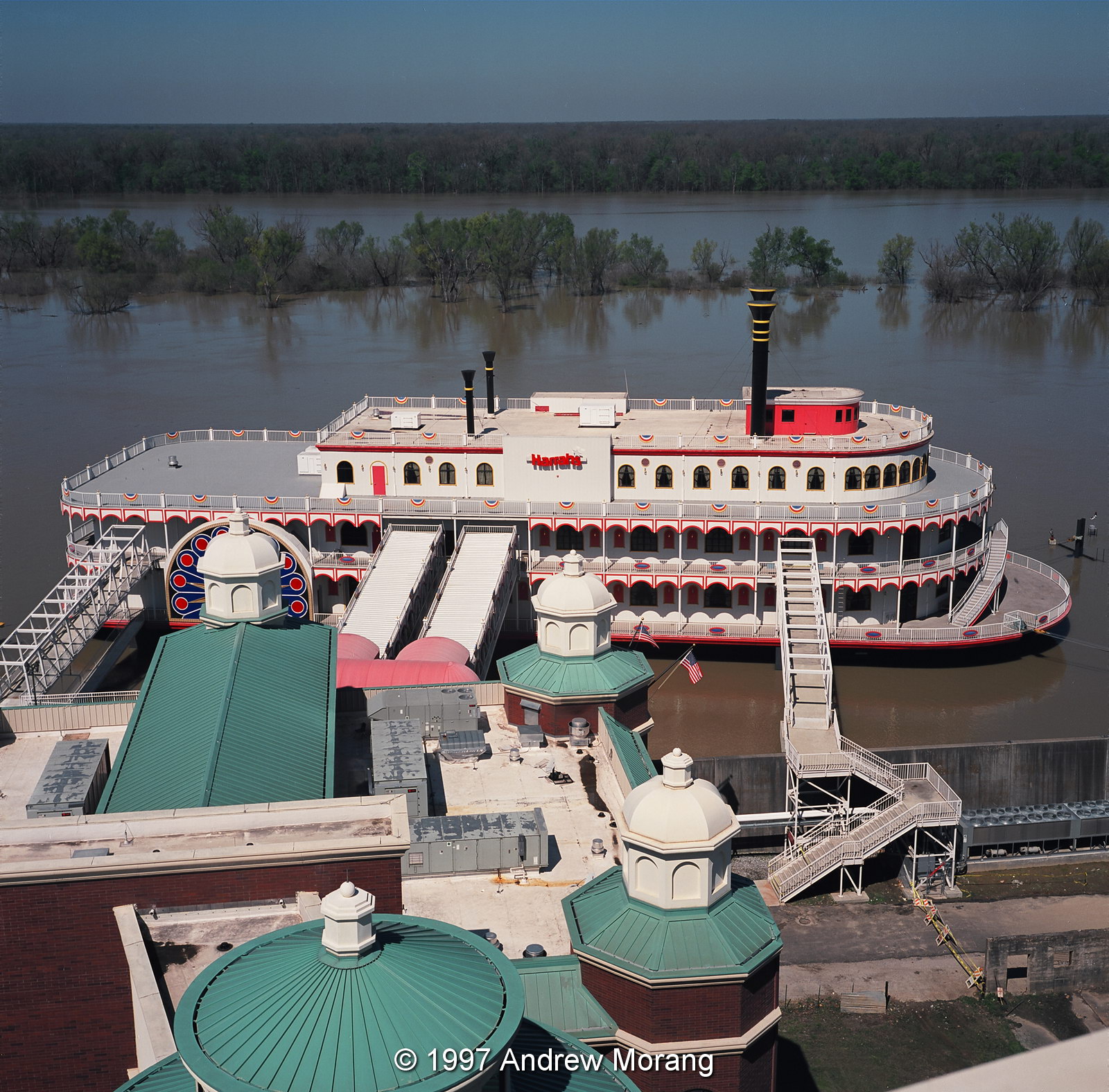
Harrah's Casino, March 1997, Kodak Ektar 25 film, Rolleoflex 3.5F camera
Let us go back in history. The casino was built by Harrah's Corporation in 1993. It was the second to open in Vicksburg after riverboat gambling was authorized by state law. At that time, a casino had to be on floating plant, so all the gambling facilities were on a barge made to look like a river boat. The hotel and restaurants could be on land. Harrah's leased land from City of Vicksburg and built a very nice hotel with a walkway to their barge.  According to the Vicksburg Post, the total investment was $30 million.  The facility became Horizon Casino in 2003 when Harrah's sold to Columbia Sussex. Several subsequent changes in ownership led to bankruptcy and an auction of the remaining assets on April 26, 2013. The City will probably never collect years of rent owed on the waterfront land.

This is the view of the Harrah's casino from the top roof of the hotel in March of 1997. The former manager kindly let me go up with some of the maintenance staff and the help of tall ladders. The river was in flood, and the coffer dam was totally covered, so the barge really did look like a river boat moored in the Yazoo Canal.
Yazoo Canal, view north
This is the view of the Yazoo Canal looking north. The water was lapping at the base of the floodwall, and the city workers had put stop logs in the wall. None of the waterfront ramp was visible. See my article on the 2011 flood for information on how the timbers are installed.
Undated post card from the Cooper collection, Mississippi Department of Archives and History
This is approximately the same view to the north, taken in the early 1900s. Notice the long covers over the platforms at the depot to provide shade for train passengers.
Yazoo Canal, view south
Undated post card from the Cooper collection, Mississippi Department of Archives and History
Looking south, Levee Street parallels the Yazoo Canal.  The confluence with the Mississippi is in the distance.  The 1997 scene is rather pathetic when you consider what a bustling commercial and industrial port this was one hundred years ago.  Then, you would have seen steamboats, wagons, supplies, timber, trains, shops, and people.
Here are city workers installing the steel uprights to prepare for high water in 2008.
This is the waterfront on May 19, 2013, with the barge gone.  The corners of the cofferdam are visible. Who will pay to remove them?  I assume they are a hazard to navagation.
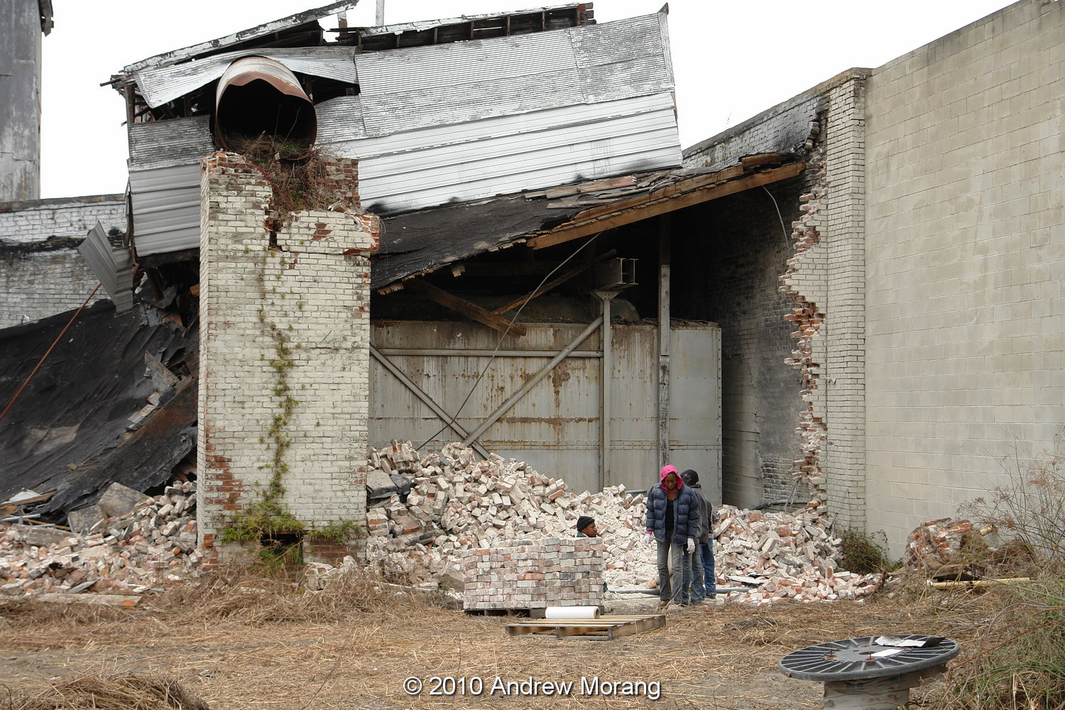
Horizon Casino awaiting scrap
The shell of the former casino is sitting at a boatyard operated by Keyes Recycling Center, Inc.  Mr. Keyes bought the barge at auction for $10,000. So much for depreciation.
Haining Road, view west, Port of Vicksburg
Haining Road and the Port of Vicksburg facilities are on fill land and high enough to be safe from flood waters.
This is a 2007 view from the Yazoo Canal of a derelict tug at the boatyard.
The Yazoo Canal was dredged in 2007 to deepen and widen it.
The low woods north of Haining Road flood when the water rises above about 42 ft.  The metal posts on the right are water pumps, used by the City of Vicksburg water plant.

For more information about river stages in Vicksburg, the list below is from the National Weather Service web page:

Historical Crests
(1) 57.10 ft on 05/19/2011
(2) 56.20 ft on 05/04/1927
(3) 53.20 ft on 02/21/1937
(4) 52.80 ft on 06/06/1929
(5) 52.50 ft on 04/28/1922
(6) 51.60 ft on 05/13/1973
(7) 51.50 ft on 02/15/1916
(8) 51.00 ft on 04/20/2008
(9) 50.20 ft on 04/16/1897
(10) 49.90 ft on 04/27/1913

Low Water Records
(1) -7.00 ft on 02/03/1940
(2) -6.80 ft on 11/01/1939
(3) -5.80 ft on 01/06/1964

The 1997 square photographs from the roof of the casino were taken with a tripod-mounted Rolleiflex 3.5F camera (Carl Zeiss Planar 5-element 75mm f/3.5 lens) using Kodak Ektar 25 film. This was the sharpest color print film ever marketed.

Update January 2015: The barge is moored in the Yazoo River Diversion Canal neat Ergon Refining; no outward change in status.

Update July 23, 2015: The hotel has been open for about a year under the name Portofino Hotel. It will close this week in preparation for construction of a new casino.

Sunday, July 29, 2012

Levee Street, the Lassiter Warehouse, and the Vicksburg Waterfront


Long-term readers may remember my 2010 post on the brick Lassiter Warehouse on Levee Street. This was the last example of this type of commercial warehouse that once lined the Yazoo canal and Vicksburg waterfront. It was partly dismantled to recycle the bricks, and now the shell stands empty and unused.

The casino just to the south is also closed. The barge is still in its artificial cofferdam lake, but the aerating machines are not running and the water is getting fetid. The property opened as Harrah's in November, 1993. It became Horizon in 2003 and was then sold to Delta Investments in 2010. As usual, fate unknown.

A good sign is the visit of the American Queen on May 17, 2012. The American Queen was launched in 1994 and may be the largest steamboat ever built (I assume this means river paddle boat). This vessel and two other others, the Mississippi Queen and the Delta Queen, were regular visitors to Vicksburg before the 2008 recession. The Delta was a classic wood steamboat, originally outfitted in Scotland and operated on the Sacramento River in California for decades. The original operator filed for bankruptcy and the American Queen was taken over by the U.S. Maritime Administration. The current owner, Great American Steamboat Company, bought it from the Maritime Administration and recommissioned it. We are glad to have her back.

The floodwall has a new mark painted on it to commemorate the record high water from the flood of 2011. This 2011 article provides some background to water levels and what the numbers mean. This article shows how the City of Vicksburg blocks the roads when the river level reaches the floodwalls.

Tuesday, January 10, 2012

Cotton Compress, Levee Street, Vicksburg, Mississippi

For many years, a complex of brick and steel sheds stood on the west side of Levee Street close to where the historic Fairground Street bridge crosses the Kansas City Southern railroad yard. This was the cotton compress, address 2400 Levee Street (see the circle on the map).
This post card, circa. 1911, is from the Ann Rayburn Paper Americana Collection, Special Collections, University of Mississippi Libraries (originally from the International Post Card Co., New York, N.Y.).
This is a glass negative from the George Grantham Bain Collection at the Library of Congress, with title, "Louisiana Flood 1912, Cotton Compress at Vicksburg as a refuge." I am not sure if any of these buildings still stand.
According to a December 17, 2010, article in The Vicksburg Post, the compress facility dates to 1903 and formerly housed a cotton gin and 13 warehouses and sheds with about 340,000 square feet of storage space. The view above was taken from the top of the levee looking east at about the same location as the 1912 flood photograph. Vicksburg is on the hill in the distance.
These two views show part of the complex from Levee Street. The Post did not specify how long the compress had been unused, but the buildings were in poor shape because of water damage and asbestos exposure following years of vacancy. Notice the sign on the ground with scripture.
This press was under the tower in the upper photograph. I do not know the mechanics of how it worked, but I remember seeing steam and activity in the 1980s, when this was still a going concern.
A developer told the city's Board of Architectural Review that the Vicksburg Compress company planned to use some of the buildings as a self-storage facility. Other buildings would be demolished, and the 1940s water tower would be removed because it was unsafe.
The interior had typically interesting industrial archaeology to examine (and I like exploring places like this). Notice the large wood timbers holding up the roof.
The grimy old workbenches still had tools, pipe, and cans of chemicals strewn about.
You could even wash up...maybe.
Someone had stored some old American muscle cars, but they were in no better condition than the buildings.
While I was exploring on a December day in 2010, a small team was cleaning up bricks and loading them on pallets.
As of December 2011, many of the brick walls are gone, and I assume the bricks have been sold. But the steel sheds are still unused, and the water tower is still standing. These projects tend to take a long time in Vicksburg.

An interesting article on cottonseed oil mills is in:  Wrenn, L. B. 1994. Cotton gins and cottonseed oil mills in the New South. Agricultural History, Vol. 68, No. 2, Eli Whitney's Cotton Gin, 1793-1993: A Symposium (Spring, 1994), pp. 232-242. (Published by: Agricultural History Society)

These are digital images from a 10 megapixel Sony R-1 digital camera, tripod-mounted. The interiors were multi-second exposures, good examples of how well-suited digital cameras are for low-light conditions. You no longer have to worry about reciprocity failure and color shifts as with film; just set the exposure and let the shutter stay open as long as needed. The R-1 has a superb Schneider lens.

Some black and white Panatomic-X film photographs of the compress are in my 2018 article (please click the link). 

Sunday, December 11, 2011

Abandoned Machine Shop, Levee Street, Vicksburg, Mississippi

From the late 1800s to mid-20th century, Levee Street, running parallel to the floodwall and the Yazoo Canal, was lined with warehouses, cotton compresses, railroad shops, grain elevators, and oil storage farms. Most are now gone, and Vicksburg is no longer an industrial city. The postcard above, from the Mississippi Department of Archives and History, shows the waterfront view from the roof of the First National Bank Building. Levee street is in the distance. In the 1980s and 1990s, this steel building (across the street from the Kansas City Southern railroad yard) contained a machine shop. I am not sure who it served, but it was a going concern, and I recall hearing metal noises and seeing pickup trucks coming and going. Now it is closed and used for junk storage. I wish I had kept a 1980s telephone book to use as a data source to identify old companies like this. The south side of the property is a dumping ground for all sorts of metal debris and parts from the railroad. This is a housing for a track-switch lever and mechanism. I like railroad equipment - heavy duty, built to last.

(Photographs taken with a Fuji F31fd digital camera at ISO100, 24 Nov. 2011)

Update: Here are some black and white film views of the workshop from December, 2020.