Sunday, May 26, 2013

The Mississippi Delta 17: Benoit

Benoit is one of many small agricultural towns in Bolivar County on the former railroad line and now served by Highway 1.  Oddly enough, Baby Doll, directed by Elia Kazan, was filmed here in 1956 (remember Carroll Baker in her tiny nightgown? - quite daring for 1950s USA.). About a half hour north of Greenville, today Benoit is quiet, slowly fading away.


These elevators, standing in 2004, have been torn down.
Even the beer joint has closed.  Notice the asphalt single siding.

This is Rice Chapel, facing Highway 1.

All photographs scanned from Kodachrome 25 transparencies with a Plustek 7600i scanner.  Original photographs taken with a Leica M3 rangefinder camera with 50 mm or 35 mm Summicron lenses.

Friday, May 24, 2013

Abandoned Utica High School, Utica, Mississippi

Utica is a small town in Hinds County about half way between Vicksburg and Crystal Springs. Like many towns throughout Mississippi, especially in the Delta, that I have described in these pages, Utica must have been active and prosperous decades ago. Today, it is a sad place; most of the stores are boarded up, there is little commercial activity. A few years ago, a block of the former commercial shops on Depot Street were dismantled for their bricks. Drive west out of town on West Main Street, turn left on Carpenter Street, and the old high school is on the left. Built in 1948, it is a traditional brick building with large windows and a cheerful look.
The large windows date to the time before air conditioning was installed in schools, and the natural light reduced the need for fluorescents.
Two of my friends attended Utica HS. One of them told me that it originally was for African-American students in grades 9-12. Students in grades 1-8 attended Mixon Elementary Colored School, a few miles north. In 1970, Utica's schools were integrated, and the first mixed black and white class met in Utica HS that year. It was renamed Utica Consolidated High School. With a satellite building to the east (now a grass field), the new consolidated school held about 800 students in six grades, with about 500 in high school.
The building has a fallout shelter in the basement. That dates it to the early cold war era, the time of "duck and cover." I recall air raid practice in elementary school in New York City in 1961. My grandmother lived in Berlin in World War II, and from her descriptions of bombings, I was familiar with the concept of a shelter.
The inner hallways were decorated with that terrible green industrial paint you see in mid-20th century schools and asylums throughout the country.
This building is still in reasonably good condition. As usual, I can't understand why a school system abandons a facility in sound condition. You wonder who really benefits from new school construction -  empire-building by bureaucrats perhaps? Kickbacks from the construction trade?
The transoms are another example of ventilation in a pre-air-conditioning era.
The Gold Waves were the basketball team.  They won many athletic events.  The trophy racks and the fantastic purple wall were in the athletic building just to the south of the main school. The roof of the field house is collapsing now and the gymnasium is a mess.

Photographs are from a Panasonic G1 digital camera with Lumix 14-45 mm lens, tripod-mounted.

Monday, May 20, 2013

Abandoned Grand Station Casino and the 2013 Mississippi River crest, Vicksburg, Mississippi

The 2013 flood season in Vicksburg, Mississippi, was notable for two reasons. First, the crest in Vicksburg occurred on May 19 with a height of 44.2 ft on the Vicksburg gauge. This was officially in flood but was well below the 57.10 ft elevation of 2011. Second, the abandoned Grand Station Casino (originally Harrah's) was towed away from the Vicksburg waterfront on Friday, May 18.
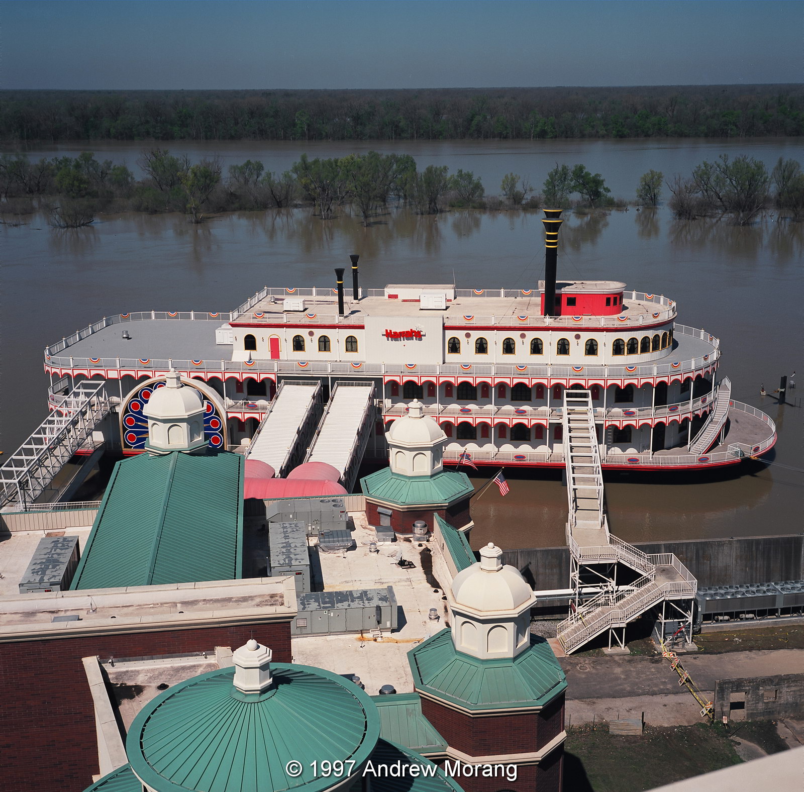
Harrah's Casino, March 1997, Kodak Ektar 25 film, Rolleoflex 3.5F camera
Let us go back in history. The casino was built by Harrah's Corporation in 1993. It was the second to open in Vicksburg after riverboat gambling was authorized by state law. At that time, a casino had to be on floating plant, so all the gambling facilities were on a barge made to look like a river boat. The hotel and restaurants could be on land. Harrah's leased land from City of Vicksburg and built a very nice hotel with a walkway to their barge.  According to the Vicksburg Post, the total investment was $30 million.  The facility became Horizon Casino in 2003 when Harrah's sold to Columbia Sussex. Several subsequent changes in ownership led to bankruptcy and an auction of the remaining assets on April 26, 2013. The City will probably never collect years of rent owed on the waterfront land.

This is the view of the Harrah's casino from the top roof of the hotel in March of 1997. The former manager kindly let me go up with some of the maintenance staff and the help of tall ladders. The river was in flood, and the coffer dam was totally covered, so the barge really did look like a river boat moored in the Yazoo Canal.
Yazoo Canal, view north
This is the view of the Yazoo Canal looking north. The water was lapping at the base of the floodwall, and the city workers had put stop logs in the wall. None of the waterfront ramp was visible. See my article on the 2011 flood for information on how the timbers are installed.
Undated post card from the Cooper collection, Mississippi Department of Archives and History
This is approximately the same view to the north, taken in the early 1900s. Notice the long covers over the platforms at the depot to provide shade for train passengers.
Yazoo Canal, view south
Undated post card from the Cooper collection, Mississippi Department of Archives and History
Looking south, Levee Street parallels the Yazoo Canal.  The confluence with the Mississippi is in the distance.  The 1997 scene is rather pathetic when you consider what a bustling commercial and industrial port this was one hundred years ago.  Then, you would have seen steamboats, wagons, supplies, timber, trains, shops, and people.
Here are city workers installing the steel uprights to prepare for high water in 2008.
This is the waterfront on May 19, 2013, with the barge gone.  The corners of the cofferdam are visible. Who will pay to remove them?  I assume they are a hazard to navagation.
Horizon Casino awaiting scrap
The shell of the former casino is sitting at a boatyard operated by Keyes Recycling Center, Inc.  Mr. Keyes bought the barge at auction for $10,000. So much for depreciation.
Haining Road, view west, Port of Vicksburg
Haining Road and the Port of Vicksburg facilities are on fill land and high enough to be safe from flood waters.
This is a 2007 view from the Yazoo Canal of a derelict tug at the boatyard.
The Yazoo Canal was dredged in 2007 to deepen and widen it.
The low woods north of Haining Road flood when the water rises above about 42 ft.  The metal posts on the right are water pumps, used by the City of Vicksburg water plant.

For more information about river stages in Vicksburg, the list below is from the National Weather Service web page:

Historical Crests
(1) 57.10 ft on 05/19/2011
(2) 56.20 ft on 05/04/1927
(3) 53.20 ft on 02/21/1937
(4) 52.80 ft on 06/06/1929
(5) 52.50 ft on 04/28/1922
(6) 51.60 ft on 05/13/1973
(7) 51.50 ft on 02/15/1916
(8) 51.00 ft on 04/20/2008
(9) 50.20 ft on 04/16/1897
(10) 49.90 ft on 04/27/1913

Low Water Records
(1) -7.00 ft on 02/03/1940
(2) -6.80 ft on 11/01/1939
(3) -5.80 ft on 01/06/1964

The 1997 square photographs from the roof of the casino were taken with a tripod-mounted Rolleiflex 3.5F camera (Carl Zeiss Planar 5-element 75mm f/3.5 lens) using Kodak Ektar 25 film. This was the sharpest color print film ever marketed.

Update January 2015: The barge is moored in the Yazoo River Diversion Canal neat Ergon Refining; no outward change in status.

Update July 23, 2015: The hotel has been open for about a year under the name Portofino Hotel. It will close this week in preparation for construction of a new casino.

Monday, May 13, 2013

Newman Plantation Store, Edwards, Mississippi

Here is another old-fashioned country store near Utica and Edwards, Mississippi: the former Newman Plantation store.  It is at the corner of Newman and Canada Cross Roads.
Map of Edwards and vicinity, with other historic stores shown (from ESRI ArcMap software)


I have little any information about the store's history.  Unlike the nearby Yates store, no one came by to chat on this quiet Sunday afternoon.  The store had the long overhang typical of early gasoline stations.  According to Tidbits and Treasures, written by Mary Landin, "Newman  Plantation covered a large area around Newman, which is the crossroads of two historic county roads that did not used to have names. No Newmans ever  lived on what is now Newman Road, because their homes face what is now  called Canada Cross Roads. When the county named them, they named the one that the Newmans thought should have been named Newman Road, Canada Cross  Roads, which is a misnomer in itself, and named the road that went to Edwards  from Newman, Newman Road."  Ms. Landin is a local historian and advocate of small-town living.

The store is locked and protected with bars, but I was able to take one photograph through the dusty glass.
Interior of abandoned Newman country store
Look at the old cash register on the shelf in the lower left. And is that a hot water radiator on the far wall?

I took these photographs taken with a Panasonic G3 camera with 9-18mm Panasonic lens or a 1949-vintage Leitz 5 cm Æ’/2 Summitar lens. The Summitar lens has been in the family since my dad bought it new.

Sunday, May 12, 2013

Yates Country Store, Utica, Mississippi

Country stores once abounded in rural Mississippi. In an era before everyone owned their own car, rural people walked or rode a carriage to the country store to buy seed, tools, groceries, books, a newspaper, candies, or to make a telephone call. In 2011, I wrote about the Betigheimer store on Hwy 27, long gone. This one is near Utica: the W.B. Yates store, at the junction of Old Port Gibson and Cayuga Roads.
W.B. Yates store, Old Port Gibson Road
This is a rather basic cinder-block structure with the squared-off front that is so common on stores and commercial buildings in early-20th century rural areas.  The grey paint makes the place more severe, but the Coca-Cola sign adds a splash of red.
I could not go inside, and all the windows were blocked with plywood.
While I was putting my tripod away, an elderly gent came by to talk. He was a relative of the Yates family. He said the present store was built in 1947 (that explains the post-war cinder blocks). The original store was across the street where a post-war suburban home now sits. Mr. Yates died in 1986 and Mrs. Yates operated the store for two more years. She died tragically when she was hit by an 18-wheeler.

The name Cayuga, as in Cayuga Road, is an Indian name. The European settlers to this area came from upstate New York, where Cayuga Lake is the longest of the glacial-derived Finger Lakes. This is different than Cuyahoga, which is the name of the river that flows through Cleveland and debouches into Lake Erie.

The gent had some other interesting stories. Nearby is Charlie Brown Road. People kept stealing the sign, and the highway department could not figure out why. He convinced them to print a sign "C Brown," and the theft problem ended.

These are digital images from a Panasonic G3 digital camera and a 1949-vintage Leica 5cm Æ’/2.0 Summitar lens, tripod-mounted. My father bought the Summitar and its accompanying Leica IIIC rangefinder camera new at the Post Exchange on Guam. Stopped down to Æ’/4.0 or so, this lens equals many contemporary optics.

Update December 2019: A cabinet-maker and carpenter is using the Yates store. We chatted for a few minutes, and he said he was very busy with projects. Good news!
W.B. Yates Store (Panatomic-X film, Hasselblad 501CM camera, 80mm Æ’/2.8 Planar-CB lens, yellow filter) 

Sunday, May 5, 2013

Abandoned Corner Store, North Mill Street, Jackson, Mississippi

In the previous post, I showed a photograph of North Mill Street taken from the Fortification Street bridge. A few blocks south, at the corner of North Mill and West Monument Streets, sits an abandoned brick store. It has been empty and decaying for at least a decade.

You can see the faded Dr. Pepper logo and remnants of other signs. In the second photograph, you can see the Fortification Street bridge in the distance.
This was address no. 703.  The store served the once-vibrant residential community just to the east.  Once there were many more stores along Farish Street.
The manhole covers are really fancy here.  Complete with a presidential eagle.  We will cover more of downtown Jackson in future articles.

Photographs taken with a Sony DSC-W7 compact digital camera.

Update April 18, 2015: the store has been demolished. I do not visit this area often, so I do not know how long it has been gone.


Wednesday, May 1, 2013

Fortification Street Oil Mill, Jackson, Mississippi

Fortification street in Jackson runs east-west and crosses over the railroad yards on a long bridge in West Jackson. Just south of the bridge is a hulking complex of steel buildings and pipes, remains of the oil mill.  I think it has been out of operation for at least a decade, but I could not find much information on the complex.
Farish Street, view north
The mill is just north of Farish Street, once a vibrant African-American community.  I assume many of the inhabitants may have worked at the mill.  The view above is from Farish Street looking north.


The Fortification Street bridge usually has pretty dense traffic, but last week, one lane was blocked off with traffic cones.  I pulled in and took some elevated views of the mill.  I saw a guard and some trucks entering, but it was unclear what activity was happening.
Regular readers of this blog know I like the stark geometric shapes in industrial sites.
This is the view north along the railroad tracks.  These are active.  Years ago, I took the train from Chicago to Jackson, and the Amtrak came into town by this route.
This is the view south along Mill Street.  It was quiet on a work day, but there was much more activity decades ago.  We will explore this neighborhood more in future articles.

All 2013 photographs taken with a Panasonic G3 digital camera, files processed in Photo Ninja.