Showing posts with label Yazoo Canal. Show all posts

Monday, May 20, 2013

Abandoned Grand Station Casino and the 2013 Mississippi River crest, Vicksburg, Mississippi

The 2013 flood season in Vicksburg, Mississippi, was notable for two reasons. First, the crest in Vicksburg occurred on May 19 with a height of 44.2 ft on the Vicksburg gauge. This was officially in flood but was well below the 57.10 ft elevation of 2011. Second, the abandoned Grand Station Casino (originally Harrah's) was towed away from the Vicksburg waterfront on Friday, May 18.
Harrah's Casino, March 1997, Kodak Ektar 25 film, Rolleoflex 3.5F camera
Let us go back in history. The casino was built by Harrah's Corporation in 1993. It was the second to open in Vicksburg after riverboat gambling was authorized by state law. At that time, a casino had to be on floating plant, so all the gambling facilities were on a barge made to look like a river boat. The hotel and restaurants could be on land. Harrah's leased land from City of Vicksburg and built a very nice hotel with a walkway to their barge.  According to the Vicksburg Post, the total investment was $30 million.  The facility became Horizon Casino in 2003 when Harrah's sold to Columbia Sussex. Several subsequent changes in ownership led to bankruptcy and an auction of the remaining assets on April 26, 2013. The City will probably never collect years of rent owed on the waterfront land.

This is the view of the Harrah's casino from the top roof of the hotel in March of 1997. The former manager kindly let me go up with some of the maintenance staff and the help of tall ladders. The river was in flood, and the coffer dam was totally covered, so the barge really did look like a river boat moored in the Yazoo Canal.
Yazoo Canal, view north
This is the view of the Yazoo Canal looking north. The water was lapping at the base of the floodwall, and the city workers had put stop logs in the wall. None of the waterfront ramp was visible. See my article on the 2011 flood for information on how the timbers are installed.
Undated post card from the Cooper collection, Mississippi Department of Archives and History
This is approximately the same view to the north, taken in the early 1900s. Notice the long covers over the platforms at the depot to provide shade for train passengers.
Yazoo Canal, view south
Undated post card from the Cooper collection, Mississippi Department of Archives and History
Looking south, Levee Street parallels the Yazoo Canal.  The confluence with the Mississippi is in the distance.  The 1997 scene is rather pathetic when you consider what a bustling commercial and industrial port this was one hundred years ago.  Then, you would have seen steamboats, wagons, supplies, timber, trains, shops, and people.
Here are city workers installing the steel uprights to prepare for high water in 2008.
This is the waterfront on May 19, 2013, with the barge gone.  The corners of the cofferdam are visible. Who will pay to remove them?  I assume they are a hazard to navagation.
Horizon Casino awaiting scrap
The shell of the former casino is sitting at a boatyard operated by Keyes Recycling Center, Inc.  Mr. Keyes bought the barge at auction for $10,000. So much for depreciation.
Haining Road, view west, Port of Vicksburg
Haining Road and the Port of Vicksburg facilities are on fill land and high enough to be safe from flood waters.
This is a 2007 view from the Yazoo Canal of a derelict tug at the boatyard.
The Yazoo Canal was dredged in 2007 to deepen and widen it.
The low woods north of Haining Road flood when the water rises above about 42 ft.  The metal posts on the right are water pumps, used by the City of Vicksburg water plant.

For more information about river stages in Vicksburg, the list below is from the National Weather Service web page:

Historical Crests
(1) 57.10 ft on 05/19/2011
(2) 56.20 ft on 05/04/1927
(3) 53.20 ft on 02/21/1937
(4) 52.80 ft on 06/06/1929
(5) 52.50 ft on 04/28/1922
(6) 51.60 ft on 05/13/1973
(7) 51.50 ft on 02/15/1916
(8) 51.00 ft on 04/20/2008
(9) 50.20 ft on 04/16/1897
(10) 49.90 ft on 04/27/1913

Low Water Records
(1) -7.00 ft on 02/03/1940
(2) -6.80 ft on 11/01/1939
(3) -5.80 ft on 01/06/1964

The 1997 square photographs from the roof of the casino were taken with a tripod-mounted Rolleiflex 3.5F camera (Carl Zeiss Planar 5-element 75mm f/3.5 lens) using Kodak Ektar 25 film. This was the sharpest color print film ever marketed.

Update January 2015: The barge is moored in the Yazoo River Diversion Canal neat Ergon Refining; no outward change in status.

Update July 23, 2015: The hotel has been open for about a year under the name Portofino Hotel. It will close this week in preparation for construction of a new casino.

Thursday, May 19, 2011

The Day the Water Crested in the 2011 Mississippi River Flood: North Vicksburg

Map of road closures and inundations. From The Mississippi River Flood of 2011, A Publication of The Vicksburg Post (© 211 Vicksburg Post)

The Mississippi river crested on Thursday, May 19, 2011 at 57.1 ft. on the Vicksburg gage, 1.1 ft. higher than the crest during the great 1927 flood. If the levees had held, the 1927 crest would have been higher, but as measured, the level was 56.0 ft at Vicksburg. In this year's flood, the Kings neighborhood in north Vicksburg was one of the wettest areas of town. In a few places, the water was right at the base of North Washington Street. In previous floods, like the one in 2008 (crest 50.9 ft.), water remained west of the railroad tracks, which served as a form of levee.

Some good news: The Waltersville Estates, operated by Vicksburg Housing Authority, just missed getting water in the ground floor units. I think no one needed to be evacuated.

Further north, conditions were much messier. This church and house are near the intersection of Hutson and North Washington Streets.

Look west along Hutson Street, and all you see is water.

In all, more than 2000 people were displaced in Vicksburg, according to the Vicksburg Post. I think most were from this low-lying area north of Vicksburg. The water is predicted to remain at this level for at least three days and slowly - very slowly - start to recede. Public Radio has already started warning people to wear protective clothing when they enter flooded homes, and the county is offering free tetanus inoculations. Rangers are on duty to help remove snakes and alligators.

Update June 19, 2011. According to the Vicksburg Post (from county and Federal sources):
  • Evacuations from Vicksburg and Warren County: 3,202
  • Structures evacuated county-wide: 1,340
  • Homes inside Vicksburg flooded: 185-200
  • Acres flooded in Warren County: 150,165
  • River flow during week leading up to crest: 2.15 million cu ft/sec (highest ever recorded)
(Photographs taken with an Olympus E-330 digital camera.)

Monday, May 16, 2011

North Washington Street Inundation in the 2011 Mississippi River Flood


By Friday, May 13, the level of the Yazoo Canal was high enough to be creeping across a low spot on North Washington Street, and the police had to block it off. This is the view north at the junction of First East and Washington Streets. Morning elevation: 55.5 ft (based on the Vicksburg gage).

(Postscript May 19, 2011: A 69-year-old Vicksburg man drowned here. City workers found the body near the flooded intersection.)

This is the view looking southwest towards the casino (May 13). The boat on the left up on a concrete platform is the MV Mississippi, the former Corps of Engineers inspection and work boat. It will become the centerpiece of the Mississippi River interpretative center. I have old photographs of railroad tracks running into this lot, but they had not been used for at least three decades. Also, years ago, a coal company was located here.

Once again, let me remind readers of the excellent historical flood photographs on the Mississippi Department of Archives and History's web page:
http://mdah.state.ms.us/arrec/digital_archives/1927flood/

Friday, May 13, 2011

As the Water Rises (2011 Mississippi River Flood): the Yazoo Canal in Vicksburg

South of the Vicksburg waterfront and landing (seen in the previous blog entry), the concrete floodwall continues south about one mile past a Bunge Corp. grain facility and the Kansas City Southern railroad yard. This is usually a bustling place with hundreds of rail cars on the tracks, locomotives being rebuilt or fueled, and workers moving about. On Thursday, May 12, the rail yard was deserted, absolutely quiet. I was astonished. The railroad moved all their rolling stock out in case the worst happens and the levees or floodgates fail. Proceed further south and the concrete floodwall ends past the now-deserted Vicksburg Compress (topic of a future article). It becomes an earthen levee at a refinery, makes a turn, and ends at the railroad tracks. The two photographs above are looking southwest towards the Mississippi River. Dorsey Street is somewhere in the water. I saw a lot of bubbles and splashing in the water. Two dogs looked like they were catfish fishing. You can drive south along a gravel road that parallels the tracks, you soon reach the Ergon Marine & Industrial Supply Dock. Diamond Jacks Casino, just to the south, closed, but Ergon built a temporary levee to keep the water out. It consists of some sort of sand-filled cribs with plastic sheeting and thousands of sand bags to secure the sheeting. What a job it will be to remove all this material later this summer. In Friday's Vicksburg Post, a guard at the Diamond Jacks parking lot said he saw boars (you know, big nasty hairy pigs) coming out of the water. Vicksburg police evacuated the city front park. (Poscript May 20, 2011: The levee around the Ergon dock failed and the area on the right side of the photograph above filled up with water.)

Saturday, January 30, 2010

Lassiter Warehouse, Levee Street, Vicksburg, Mississippi


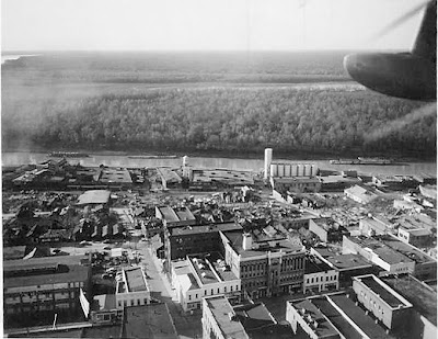
In the late 1800s and up through the mid-20th century, Vicksburg was a bustling manufacturing and trading city. The waterfront was lined with warehouses, foundries, small factories, and processing plants. The black and white aerial photograph, taken in 1953 after the tornado, shows how downtown Vicksburg was entirely developed. (The post-tornado photograph was loaned by a generous coworker. The tornado will be the subject of a future essay).

By the time I moved to Vicksburg in the 1980s, many buildings had been torn down. Old-timers still speak of the inept redevelopment efforts in the 1970s that led to the destruction of so much of the city's heritage. Today numerous empty lots provide few clues to the commercial buildings, hotels, shops, and houses that once stood there.


The white brick building in the second photograph was the W. W. Lassiter Warehouse at 1308 Levee Street, also known as the Surplus City Building. From the Vicksburg Foundation for Historic Preservation (http://www.preservevicksburg.org/):

"Built about 1907, this is the last remaining warehouse along the city's waterfront in an area that was lined with brick warehouses of every description, and was historically the largest and most important wholesaling district in Mississippi. When the Lassiter Warehouse was built, it was one of 50 warehouses and commercial buildings on the Vicksburg commercial waterfront. Original roof trusses, brick arches between rooms, windows, doors, fireplaces, cypress floors, and coal chutes remain, although some elements have been hidden by new materials."


Photographs 3 and 4 show the wood supports and massive bearing walls in the basement. The cypress posts were reasonably resistant to termites, and the floor joists were probably heart pine. The high pitch content also usually resisted termites. We rarely see construction of this quality today.

Sadly, the building was partly dismantled in 2008. The bricks were recycled.

May 2012 update: The shell of the warehouse remains, but there is no action on dismantling the remainder. The casino is also bankrupt and closed, so this part of Levee Street is pretty forlorn.