Thursday, May 10, 2012

Farmers' Market in Vrachati, Greece


This topic does not cover decay but the opposite: the agricultural wealth of spring. Spring in the Peloponnese is just gorgeous. The mountains still have snow, the streams are still running, and the fields are bursting with new growth. Vrachati is an agricultural town on the coastal plain facing the Gulf of Corinth, about 20 km west of the city of Corinth. Every Friday, a regional farmers market is held in the central street and plaza. Quite a mixture of vendors show up: farmers, artists with the standard nick knacks, gypsies with plastic furniture, and importers of cheap socks and underwear.


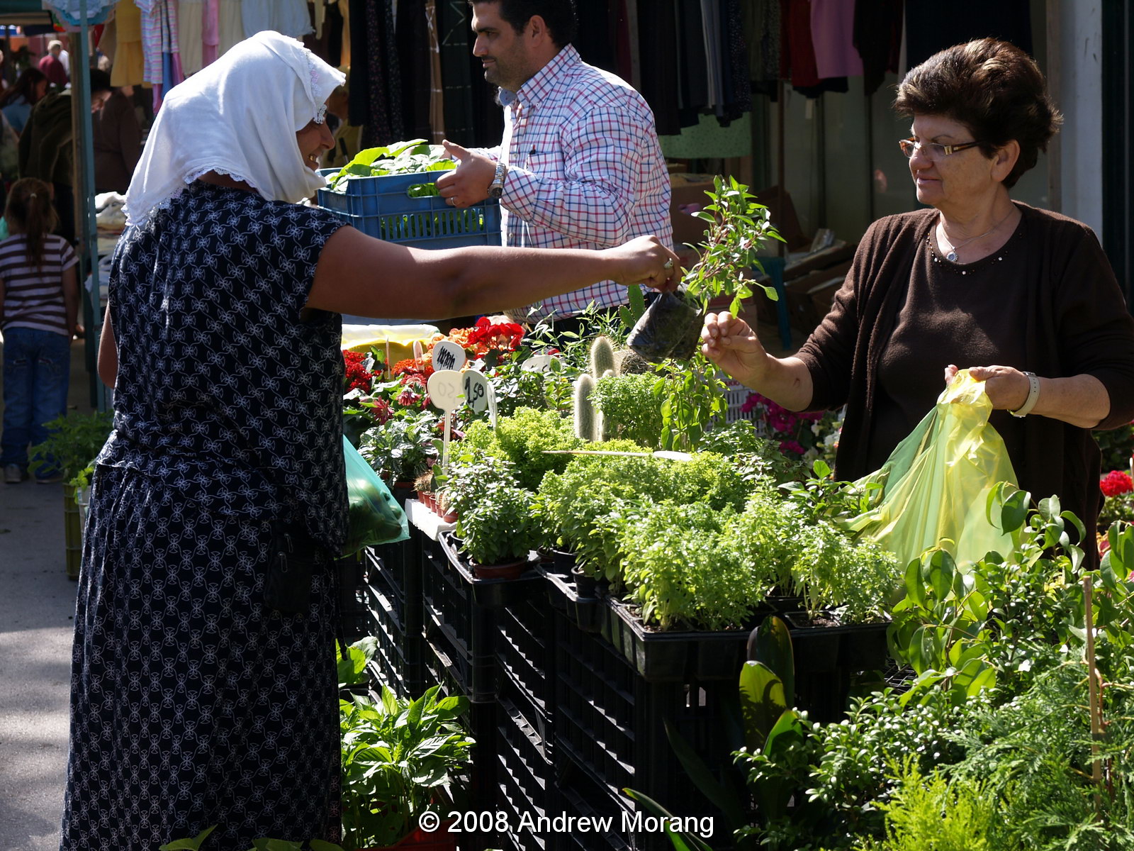
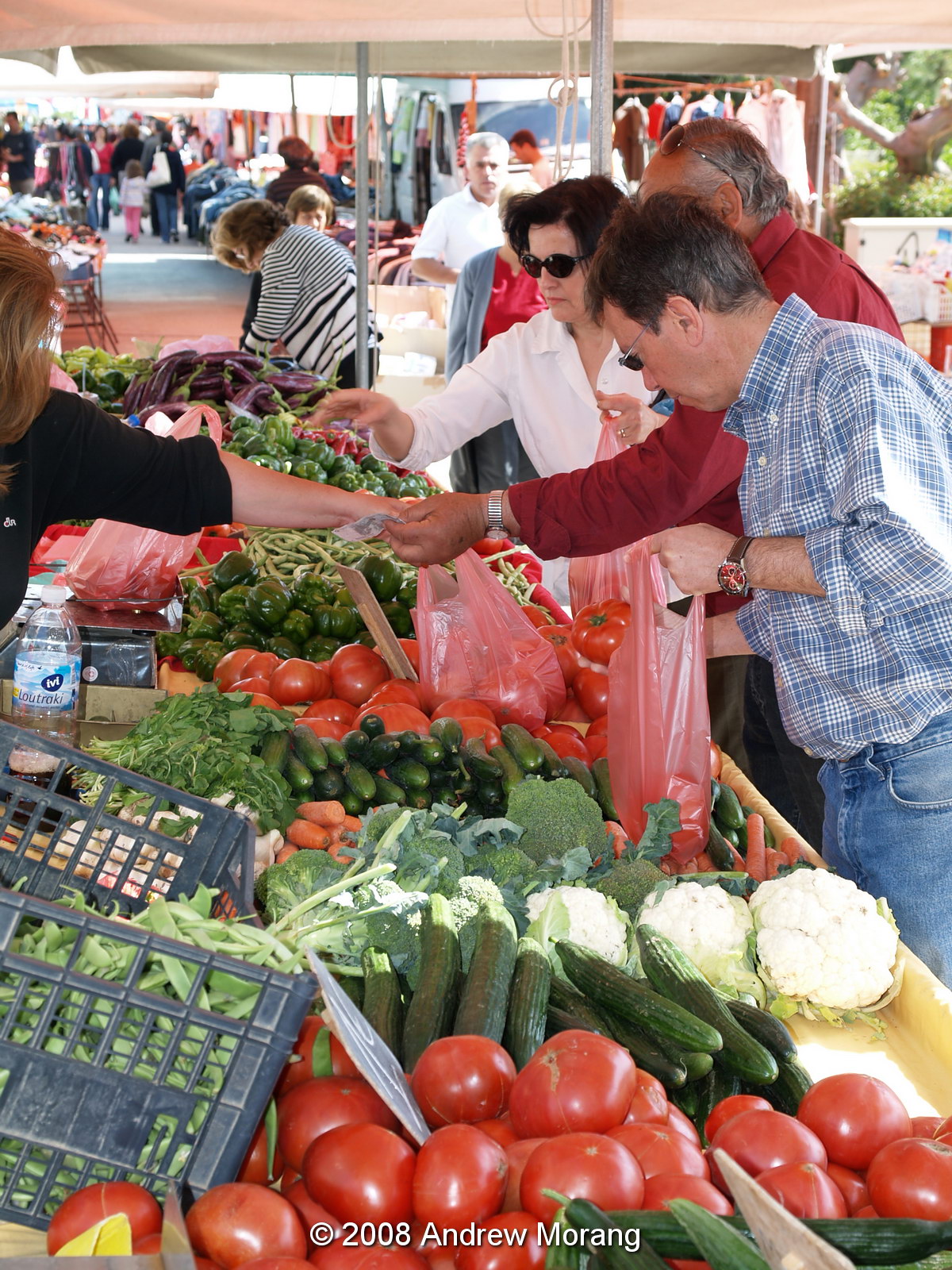
You see a variety of shoppers, including locals and city dwellers buying supplies before heading home to the city (this usually means Athens).


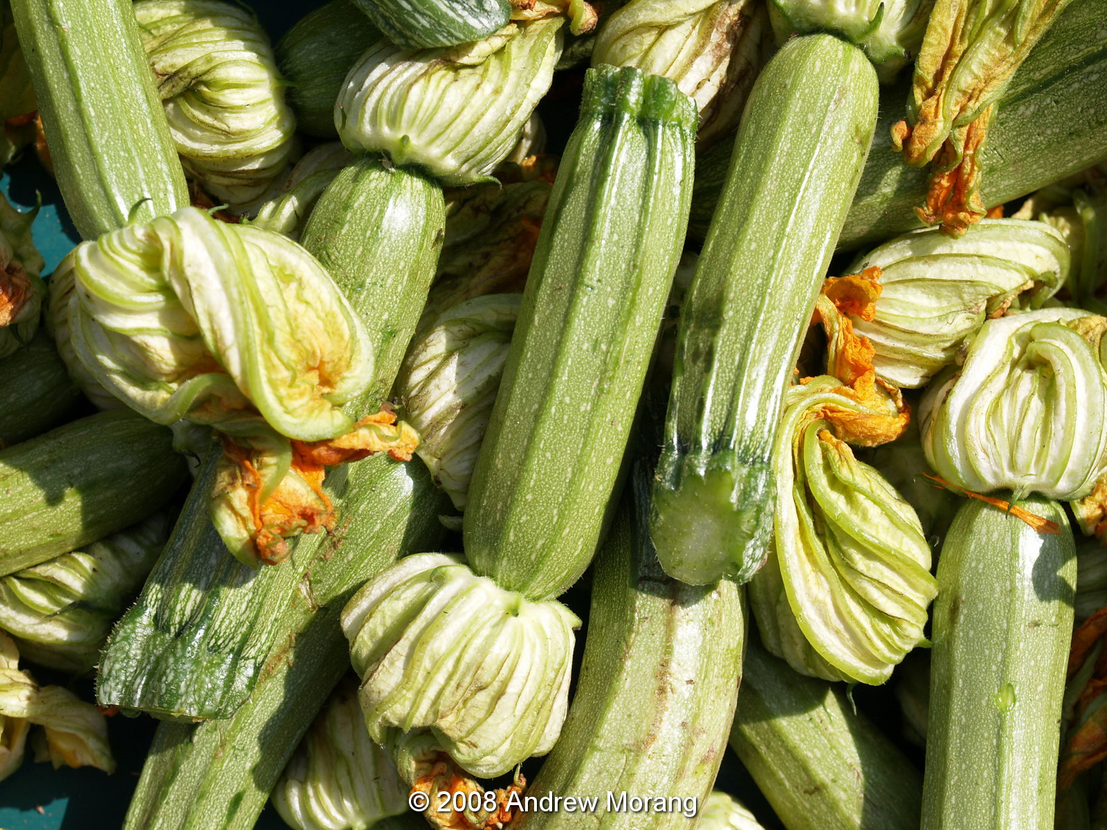
Of course, the produce looks really good. Once could easily become a vegetarian in Greece and live happily.


Winter is also scenic. The vineyards in the photographs above are near Halki, about an hour drive south (inland) from Vrachati.

Food everywhere is Greece is great. The ultimate farmers' market is the famous Central Market in Athens, featured in my 2011 article. Want some cheese? Plenty to select.

Nuts and figs? You can find the best here, including the figs from Kimi, a town on eastern Euboea (Greek: Εύβοια, Évia). The Kimi figs are reputed to be the best on earth - why would I disagree?

Even a regular commercial supermarket in Athens (this one in the suburb of Halandri) has great produce - hmmm, maybe better than one of our Krogers or Safeways?

And for readers with a sweet tooth, any sweet shop in Athens will fill you with nuts, honey, chocolate, espresso, and kilocalories. Back in USA, you will wonder how we can eat the offal that pass for cakes and pastries.

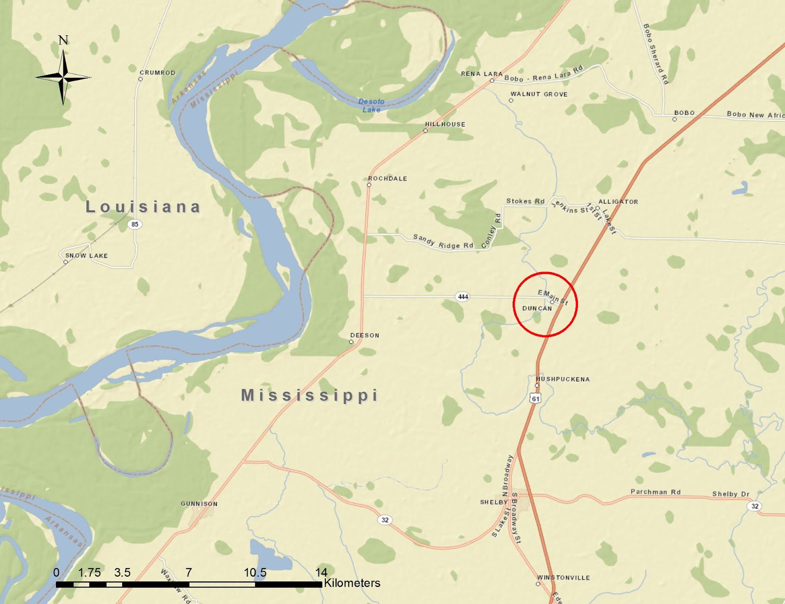
I took the Vrahati frames with an Olympus E-330 digital camera with 14-54mm lens. The background map is from ESRI® ArcMap™ software using ESRI maps and data.

Saturday, May 5, 2012

First Cemetery, Athens, Greece


The First Cemetery of Athens (Greek: Πρώτο Νεκροταφείο Αθηνών) is an oasis of peace and calm in the noisy, frenetic city. It covers an area of about 500x500 m, a green space of pines, cypresses, and narrow walkways. Many heroes of the 1820s War of Independence are interred here, as are other notables of Greek society, prime ministers, poets, archaeologists, and prominent foreigners.  The tomb of Heinrich Schliemann, the discoverer of Troy, is here. Most of the interred were Greek Orthodox, but there is a Catholic church on the grounds, and separate areas are reserved for Protestants and Jews.


Located southeast of downtown in what is now a mixed residential and small-shop district, the cemetery is at the end of Anapafseos Street (Eternal Rest Street - what an appropriate name!). Your initial approach is a bit discouraging. Parking is always a chore, and the entrance area is a bit grubby and looks well-used. The severe marble colonnaded entrance is not very classical-looking.

Once inside it is more peaceful, and the wide marble plaza is lined with cypress trees. The temple you see on the left is Schliemann's tomb.


No one bothers you, and you can spend hours walking the shaded lanes between tombs and statues.


The statuary is beautiful and much is of white Pendelian marble (the same micro-crystalline marble used on the Parthenon). Notice the owl, an ancient symbol of the dead.


This is the famous "sleeping Girl," the Tomb of Sofia Afentaki, a work by the sculptor Yannoulis Chalepas from Tinos.  Tinos, an island in the Cyclades, has a famous carving school, and many of its graduates have worked around the world.


The lion has an almost Egyptian look.

Some prominent British diplomats who supported Greek independence are also here.


Space is at a premium, and many family tombs or monuments contain bones of multiple generations. Any day, but especially on holidays and Sundays, you will see family members cleaning the walks near their family tombs, disposing of dead flowers, and paying respects. First Cemetery is not on the normal tourist route, but well worthwhile.

All photographs taken with an Olympus E-330 digital camera with Olympus 14-54 mm lens, black and white processed in-camera.  Map drawn with ESRI ArcMap software.

Saturday, April 28, 2012

Historic Houses, Ano Trikala, Peloponnese, Greece


Drive about three hours west of Athens into the northern mountains of the Peloponnese, and you reach a cluster of historic villages on the north slopes of Kyllini (click for the Google map link). At an altitude of about 1100 m (3600 ft) they are cool even in summer and snowy in winter. The area is famed for cherries and olives. Built on the ruins of the ancient Miseo, the villages consist of Kato (Down), Mesaia (Middle) and Ano (Up) Trikala, but really merge into one community now.


Trikala has been occupied for a long time. You can see semi-ruined stone houses throughout the town, many of which may date from the late-1800s or early 1900s. They typically were built of stone walls and wood roof joists, so even after the roof rots and fails, the walls will remain for decades or centuries.

A few notes on rural depopulation: Until the early 1960s, Greece had a largely agrarian economy. Many villagers lived an almost self-contained existence, growing their own produce, and selling some products, such as olive oil, in coastal cities. Because of bad roads, a trip to the coast from an interior village was a long and tiring effort. Starting in the 1960s, Greece experienced an economic boom, and with it came better roads and education. Children were educated and moved to the city. Urban life was easier, more exciting, and more cosmopolitan. Many only occasionally returned to their original homes to see their parents and grandparents, and slowly, many interior villages depopulated. By now, two generations have lived in the city, and many of these city dwellers have no interest in the backbreaking work and comparative loneliness of a mountain village (Where are the nightclubs, the shops, the music scene?). A moving and personal description of the gulf between urban and rural residents is described in The Olive Grove: Travels in Greece, by Katherine Kizilos, an Australian journalist of Greek descent (Paperback: 260 pages; Publisher: Lonely Planet Publications (September 1997); Language: English; ISBN-10: 0864424590).


Some older houses have been restored and are occupied, such as this handsome house with a carved doorway.


The prosperity of the late-1990s and early 2000s brought tourism to some towns, especially ones like Trikala with spectacular settings and great views. The developers moved in and overbuilt vacation bungalows and apartments. Just as in the USA, many are now bankrupt, and their apartments stand empty. With the ongoing financial crisis, few Greeks are buying property now. The eternal dream is that rich Germans or Americans will come to Greece, buy property, and spend money. Vacation bungalow anyone?

(All photographs taken with a Fuji F31fd digital camera. This time I violated my normal tripod rule on architecture and hand-held the camera.)

Wednesday, April 25, 2012

The Mississippi Delta 11: Duncan


Duncan is another small agricultural town in Bolivar County, in the heart of the Mississippi Delta. Like the towns featured in previous entries, the Yazoo and Mississippi Valley railroad tracks once ran through the commercial center of town, but a resident told me they were removed in the early 1980s.

To reach the center of town, you turn off U.S. 61 and drive west on East Main Street (also called Hwy 444). This former country store is on the south side of East Main. I wonder if it was once a gasoline station with room for a customer to pull in under the overhang? Many early 20th century filling stations looked like this.


Further west on East Main, I came across this curious store with a 45 degree front, about 1920 vintage. Another former filling station? Just next door was this contemporary blue food mart. Many of the convenience stores and gasoline stations in the Delta are run by Pakistanis and Indians.


Turning left on West Part Street, I came across the efficient-sized Town Hall (or at least, that was clearly this building's original purpose), c. 1910.


East and West Park Streets once paralleled the railroad tracks. These small commercial buildings were on East Park, facing the tracks.

This building on West Park was a former service station, according to a gent I met. Notice the patterned stucco/cement siding, made to look like limestone blocks. Many late-1800s houses in Vicksburg have similar patterned stucco.

Finally, this little steel building was once a seed store. Duncan is a cute little town, very quiet at dusk.

All photographs taken with a Panasonic G1 digital camera with 14-45mm Lumix lens, tripod-mounted.

Update February 3, 2015: MississippiPreservation wrote an interesting article on the February 25, 1929 tornado, that killed 21 people and destroyed 100 homes.