Showing posts with label California. Show all posts

Sunday, February 21, 2021

Repurposed Ranch Lands: Wildwood Canyon State Park [Guest post by morangm]

[Guest post by morangm]

Wildwood Canyon State Park, located in the foothills of the San Bernardino mountains in Yucaipa, California, is a really lovely place to spend an afternoon. The park boasts beautiful scenery full of native California vegetation, including some oak forests, and also some nice views of the surrounding valleys from the ridges. The park is a great location for hiking, horse riding, mountain biking, wildlife watching, and native plant observation. Pre-pandemic it was a very quiet place, despite being close to a populous and growing urban area. On most of my visits, there was hardly anyone there. It seems to have gotten more popular since the pandemic has driven people toward more outdoor recreational activities.

Native oak forest in Wildwood Canyon State Park

The park also houses some abandoned ranch houses, the type of topic Kodachromeguy really likes, and hence why I am writing this post.

According to the park brochure, the park's territory has had failed large-scale development planned more than once. In the 1920s, a country club development was planned, but there was little interest from buyers, and most of the lots remained unsold. The property was then sold to Vernon Hunt, who used the lands for his ranch starting in 1940. Another portion of the park lands was owned by the McCullough family, who built "Hi-Up House" in the 1930s and lived off the land. More recently, developers planned to build a new subdivision on the land, but a flood disrupted those plans. Instead, the State of California purchased the land and turned it into a park in 2003.

Today, you can hike about a mile from the parking area to the remnants of the Hunt Ranch. It's a mix of picturesque wooden buildings that are probably the originals from the 1940s and some newer equipment storage hangers with corrugated steel walls and roofs.

Old stable (?), Hunt Ranch, Wildwood Canyon State Park
I guess this was a stable.
Chicken hut and equipment storage, Hunt Ranch, Wildwood Canyon State Park
The building in the foreground seems to have been for chicken. The hangar in the background has rusted bits of farm equipment in it.
Unknown building, Hunt Ranch, Wildwood Canyon State Park
I'm not sure what this was. Maybe living quarters. Leave a comment if you know.
Unknown building, Hunt Ranch, Wildwood Canyon State Park
Presumably more living quarters with storage underneath
Old truck, Hunt Ranch, Wildwood Canyon State Park
Can anyone tell me what model of truck this is/was?
Newer house, Hunt Ranch, Wildwood Canyon State Park
A more modern house, equally abandoned
Newer stables, Hunt Ranch, Wildwood Canyon State Park
Newer stables, equally abandoned. Nice place for a picnic.
The acorn woodpecker is a common bird species in this part of California. Unlike most other woodpeckers, it is a social bird and lives in groups. Acorn woodpeckers peck holes in tree trunks, telephone poles, and...houses, and they store acorns and other nuts in these holes. This is for long-term food storage and also, presumably, so they can keep the nut still while they break it open to get the meat out. Virtually all the old wooden buildings in the park are riddled with acorn woodpecker holes. While the State of California seems to be doing general maintenance to keep the abandoned buildings safe, they will have quite a chore on their hands if they decide to fully restore them.
Acorn woodpecker holes, Hunt Ranch, Wildwood Canyon State Park
Acorn woodpecker holes in the wood siding of one of the abandoned Hunt Ranch wooden buildings
Hi-Up House is on the other side of the park, also roughly a mile from the parking area. This house sits on a ridge and has a lovely view of a meadow and the valley beyond it. The front porch/balcony is a nice place to stop for a water break and to enjoy the view or even watch the sunset. On a previous visit, I watched a bobcat on the prowl in the meadow. A fellow visitor told me that Hi-Up House had been used as a boy scout retreat, but I was unable to verify this information.

The house seems to be in pretty good shape, and the roof looks new. Maybe one day the State can turn this into a park visitor center. I hope they can at least fix the floor of the balcony, which is deteriorating.
Hi-Up House, Wildwood Canyon State Park
Hi-Up House, front view
Hi-Up House, Wildwood Canyon State Park
Hi-Up House, back view. The roof is in great shape, so clearly it's been maintained recently.
Hi-Up House, Wildwood Canyon State Park
Hi-Up House balcony
Hi-Up House, Wildwood Canyon State Park
Nice place to watch the sunset
Wildwood Canyon State Park was fortunately spared during the massive El Dorado fire in September of 2020. (That was the fire caused by a pyrotechnic device at a gender reveal party.) A park visitor told me that there had been more wildlife in the park this year because of habitat destruction caused by the fires. She said last fall, right after the fire, it was common to see herds of 20 or 30 mule deer hanging out in the parking lot. Let's hope in the future that these lands can continue to provide a refuge for both wildlife and people who need a break from urban life.

Because Kodachromeguy always does this: All photos were taken with a Samsung Galaxy S10e smartphone.

Wednesday, April 15, 2020

The vacant lots of downtown Redlands, California

(Guest post by morangm)

Most of Kodachromeguy's posts here feature abandoned and decaying rural towns in areas that are losing population and economic activity - places that are just no longer needed. In today's post, I'm going to talk about a different situation - decay caused not by decreasing population and economic declines, but rather decay in the midst of rapid growth, caused by self-defeating municipal ordinances.

Redlands, California, is a cute historic town about 60 miles east of downtown Los Angeles.  Although it was originally an independent town settled by wealthy easterners seeking a pleasant climate for retirement and those seeking their fortunes in citrus cultivation, it has long since become attached to the ever-expanding Los Angeles metropolitan area.  This area of California, the "Inland Empire", is one of the fastest-growing regions of the country.  According to a recent demographic analysis by the City of Redlands, 80% of people who live in Redlands do not work in Redlands, and 80% of people who work in Redlands don't live in Redlands.  So, while Redlands fiercely clings to its historical identity, it is no longer a self-contained entity.  Like it or not, it is part of a broader metropolitan community.

In the 1970s, 1980s, and 1990s, Redlands voters, alarmed at the rapid growth of the region, adopted some slow growth municipal ballot measures and propositions. These measures, among other, more technical things, limit the number of new dwelling units that can be built within the city limits each year to 400 and cap the height of new buildings.  Redlands is by no means the only municipality to adopt slow growth measures like this, and it is exactly these types of restrictions, adopted by many communities across metropolitan areas, that have contributed to urban sprawl and worsening traffic congestion.  If you don't build up and in, you have to build out.

Redlands has a small but relatively lively and pedestrian-friendly downtown area which spans for about 4 blocks along State Street, with some activity in the surrounding blocks.  Unfortunately, despite the region's overall economic growth, the area immediately west of downtown has declined in recent decades.  The Redlands Mall, built in 1977, was placed squarely in the middle of what was once State St., bulldozing many historic buildings and effectively cutting off the main downtown corridor from the other end of State St.  The I-10 freeway cut the city in half, blockading the northern residential areas from downtown. Additionally, the freight and passenger rail corridor ended service at some point, and various industrial and warehousing businesses closed up.

The slow growth restrictions in Redlands meant that redeveloping these central areas of town was not economically viable for developers.  The Redlands Mall has sat abandoned for 10 years (which doesn't sound like much, but remember this is one of the fastest-growing regions of the country we're talking about!).  There are many other vacant lots and abandoned buildings that no one is willing to invest in.  Developers just can't turn a profit redeveloping a downtown area in California if they can't build upwards.
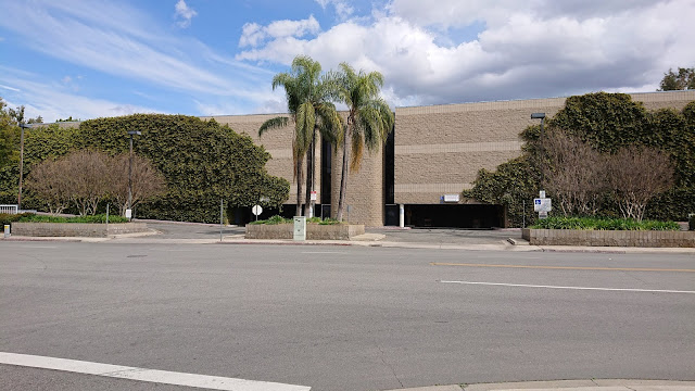
Redlands mall
The abandoned Redlands Mall
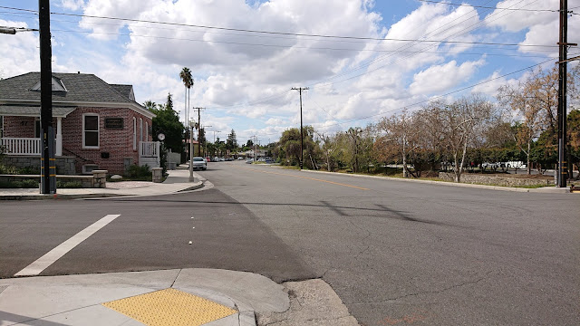
West State Street
West State St, the part cut off from downtown by the Redlands Mall, with the Chamber of Commerce on the left.
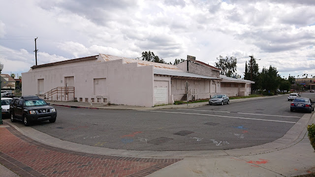
Abandoned warehouse or packinghouse
Abandoned warehouse (possibly a citrus packinghouse?) right next to downtown
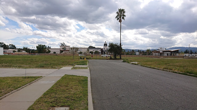
Vacant lot
Vacant lot and parking lot downtown. The backside of the abandoned warehouse is in the background.
Empty dead end
Empty dead end downtown with Studio Movie Grill (formerly the Krikorian Cinema) in the background
Abandoned house
Abandoned house abutting the highway (in the background)
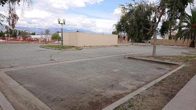
Unused parking lot
Unused parking lot currently being utilized for construction storage. This will probably become parking for the adjacent rail station. I think this is the site for the newly-planned parking garage.
Rail corridor
Empty land and the newly-graded rail corridor
Boarded-up historic trolley
Hey, I found a trolley!
The Los Angeles commuter rail system, Metrolink, is currently expanding its service out to Redlands, revitalizing the old abandoned rail corridor and the historic Santa Fe depot.  As part of this effort, the City of Redlands got a grant to develop a really great transit-oriented development plan to guide redevelopment efforts for the area around the three new rail stops, which encompasses the Redlands Mall and other vacant and abandoned areas in the downtown core.  City staff and hired consultants spent over a year developing this long-term plan for walkable, bike-friendly, mixed-use development.  They held a series of public workshops to learn what the community wanted and to solicit feedback on the plans.

The plan, called the Transit Villages Plan, lays out new zoning for the plan area, allowing buildings of 4 stories on average (with some sections of up to 5 stories allowed for architectural features) in the central part of downtown, with building heights tapering off as you get farther from downtown.  The plan also specifies various architectural requirements to maintain the character of the town and prevent ugly big square boxes from being built, etc.  It seemed like a good plan!  It would help us to redevelop the decayed areas of downtown, encourage environmentally responsible and sustainable development patterns, accommodate necessary and desirable growth in a controlled manner, and ensure that we maintained the charm and character of the city.

However, the City's vision for this new denser, mixed-use development couldn't come to fruition with the existing voter-approved slow growth restrictions in place.  So, the City put on the March 2020 ballot a new measure, Measure G, which would remove the old slow growth restrictions for the area within the Transit Villages Plan area (so, not the whole city, but just the downtown core).

Redlands went nuts!  In the month or two preceding the Measure G vote, a vigorous public debate broke out in the local newspapers and social media.  Although response to the Transit Villages Plan at the community workshops had seemed largely positive, there was immense pushback to Measure G.  NIMBYism took hold. People didn't want to encourage more development in Redlands, didn't want to welcome new apartment-dwelling neighbors, and didn't want their views of the mountains obstructed by taller buildings downtown.  But the debate was wild.  Measure G's actual text was technical and confusing, and the City did a poor job of proactively explaining what it meant in lay terms and even explaining how the urban planning process works, what zoning is, what the existing measures were, etc.  By the time the City finally released an FAQ that laid out clear information, the conspiracy theories had already made the rounds, people's emotions had already been roused, and the local Tea Party had organized in a serious way to oppose the measure.

Measure G failed miserably. About 65% of voters opposed it.

So what does this mean for the vacant lots and abandoned buildings of downtown Redlands?  It remains to be seen.  The City will have to redesign the Transit Villages Plan to conform to the old slow growth measures.  Will developers be willing to invest in these properties given the limitations?  We don't know.

Further confusing the problem is that the State of California has been aggressively pursuing legislation to increase the housing supply across the state, precisely because municipal slow growth measures like those in Redlands are driving up housing costs and encouraging sprawl.  Some state legislation actually removes municipal new housing unit limits, so even without Measure G, parts of our slow growth limits are moot.  The state is also requiring communities to provide large numbers of new housing units over the next several years.  It's unclear to me exactly how this works, but my understanding is that if a City's zoning code does not conform with state requirements on housing provision, the City has no grounds to say no to a developer proposing housing units in whatever form.  Thus, we may end up with denser high-rise development downtown anyway, but it won't be subject to the Transit Villages Plan's careful architectural guidelines. We may be stuck with whatever the developer wants to build with no local say in the matter.  We might also end up bulldozing our few remaining orange groves on the outskirts of the town and turning them into housing developments, and people will build Granny flats in their garages or backyards.  And if we don't conform to the State's requirements, we risk losing state funding for things like road construction.

So, the future of Redlands remains pretty uncertain for the moment.  The way I see it, the failure of Measure G seems fairly self-defeating.

To be clear, there is some activity happening among all the vacant lots.  The new Redlands Packing House District shopping center has been successful, Escape Brewery moved into the old Rondor building (a former trolley depot), and there's a new market-style eatery in the works in another old packinghouse.  But none of this helps the housing situation, and it's not the walkable mixed-use development we envisioned in the Transit Villages Plan.
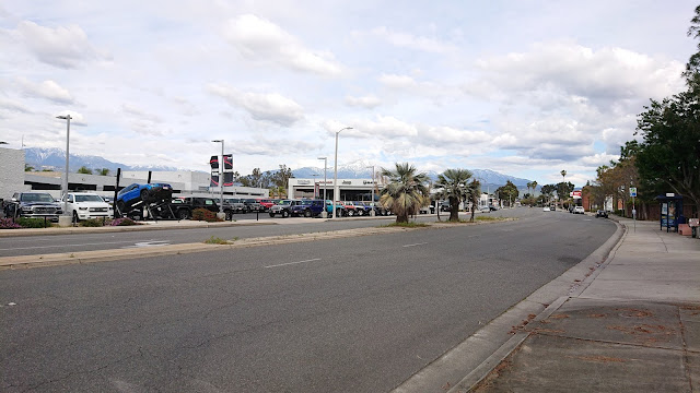
Redlands Blvd
Redlands Blvd just west of downtown. Perhaps the now-empty part of downtown will eventually look like this?
Further reading:
Because Kodachromeguy always does this: All photos in this post were taking with a Sony Xperia XZ2 Compact smartphone.  And for the record, Redlands almost never has this many clouds in the sky.

Thursday, January 18, 2018

Odd in the Desert: Salvation Mountain, Salton Sea, California


Drive southwards along the east shore of the Salton Sea in southern California, pass a U.S. Citizenship and Immigration Services (USCIS) checkpoint (yes, they have a new bureaucratic name), turn left at the sign for Slab City, and you come to a man-made mountain. This is the famous Salvation Mountain, the life work of Leonard Knight (1931–2014), who made this edifice of straw bales and adobe mud, covered with gallons (tons?) of paint. According to Wikipedia, the edifice "encompasses numerous murals and areas painted with Christian sayings and Bible verses, though its philosophy was built around the Sinner's Prayer."


There are plenty of painted artifacts here, with Love, God, and other homilies in bold colors. These remind me of the folk art at Margaret's Gro, on North Washington Street, in Vicksburg, Mississippi. That, too, was built by a preacher as his Temple to the Lord.


It surprised me that this is a popular wedding photography site. Well, why not? But the light is harsh; the couple this day needed an assistant to hold a sun diffuser.


Drive a couple of blocks through Slab City, round a corner, and you reach East Jesus. According to Wikipedia
"Slab City, also called The Slabs, is largely a snowbird community in the Sonoran Desert located in Imperial County, California, 156 miles northeast of San Diego within the California Badlands, and used by recreational vehicle owners and squatters from across North America. It took its name from concrete slabs that remained from the abandoned World War II Marine Corps barracks of Camp Dunlap." 
The marine base closed in 1956, and the land status is a bit murky but likely belongs to the State of California. The residents of Slab possibly could be classified as squatters, but they certainly are creative ones. "East Jesus is an experimental, sustainable and habitable art installation" made from recycled materials and discarded electronics. Interesting stuff; it is well worth a drive to the Salton Sea if you are passing through southern California. Well, skip mid-summer, when the temperature is well over 100° F.

I took these photographs on Fuji 200 film with my Yashica Electro 35CC compact rangefinder camera. I scanned the negatives with a Plustek 7600i film scanner using Silverfast Ai software.

Saturday, December 9, 2017

Abandoned Rocket Fuel Plant, Redlands, California


Redlands, California, is a historic town on the far east outskirts of the Los Angeles metropolitan area.  The historic core is well-represented by gorgeous Craftsman architecture houses in impeccable condition. But drive to the unincorporated town Mentone, turn north on some gravel roads towards the Santa Ana River wash, and you come across a wasteland of boulder fields, water retention pits, and hulking concrete bunkers. The bunkers are the remains of the Lockheed Propulsion Company, which developed and tested solid fuel rocket motors and propellants for use by the military and NASA between 1961 and 1975. The Grand Central Rocket Company used the site before 1961.


Southern California was, for many decades, one of the prime locations for the United States aerospace industry. After World War II, aircraft companies expanded their operations to encompass the new rocket and space technologies. This accelerated after the 1957 launch of Sputnik and in the 1960s, as we developed equipment and systems for the space race.


These were sturdy buildings, with thick reinforced concrete walls. Some semi-buried bunkers (see the fourth photograph) were made to store highly explosive materials. Bunkers like this are built with thick earthen sides and a thin roof so that an explosion will dissipate its energy vertically into the air. Note the troughs in the floor through which cables and conduits could be routed.


These rectangles contain glass at least 6 inches thick. They were designed for movie cameras to film rocket nozzle exhaust. I have seen windows like this at an old building (no longer extant) at the Waterways Experiment Station in Vicksburg, Mississippi.


According to a Wikipedia article, the Lockheed plant closed in 1975 when the last contracts for the Apollo program ended and NASA selected Thiokol to prepare solid propellant for the Space Shuttle booster rockets. Solvents and other toxic chemicals have been measured in water wells in the region. Nevertheless, Lockheed-Martin Corporation has refused to pay for the clean-up of the contamination. Is this not a familiar story?

For more articles on Redlands, please click the links:
1. Restoring the Santa Fe Depot.
2. Historic Redlands High School's Clock Auditorium.
3. A quick tour of Craftsman houses.

For an odd site in the California desert:  Salvation Mountain.

The photographs of the rocket fuel plant are from a compact Yashica Electro 35CC film camera with a fixed 35mm f/1.8 Color-Yashinon lens. My impression is that the lens may be giving slightly more coverage than 35mm, but regardless, it is a handy focal length for street and casual photography. The film was Fuji 200, purchased in Kathmandu, Nepal. I scanned the negatives on a Plustek 7600i 35mm film scanner using SilverFast Ai software.


Update January 2018
A retired rocket scientist, Mr. C.E. Juran wrote to me. He worked at the site, which was then run by Grand Central Rocket, from 1956 to 1966. He confirmed that Lockheed left a mess when it closed the site in 1974. Recall, in that era, there was minimal environmental awareness. The photograph shows Mr. Juran with a rocket being assembled; the propellant "grain" is suspended above the pressure case.


Update July 2022

A short commemoration of Mentone's 135th birthday in the Redlands Community News summarized the history of the rocket fuel facility.   

Friday, August 5, 2016

Travels on the Mother Road, Route 66 - Part 4, the Mohave Desert East

In the central Mohave Desert of California, Route 66, also known as the National Trails Highway, runs several miles south of I-40 on its way to the Arizona border. Although 66 seems to be out in the middle of nowhere, when I was there in early April, there was a steady stream of tourists cruising along. Still, be prepared, make sure your car is in good condition, and carry a lot of water, especially if you will be driving this stretch in summer.
Continue east from Amboy, and soon you reach Cadiz Summit. There is not much there other than an abandoned tourist complex.
Essex, now we are in a town. Well, maybe the ambitions of riverfront property exceeded the reality of the river. The Route 66 Adventure Handbook says General Patton's troops trained here in 1942 to prepare for the invasion of North Africa.
The National Trails Highway loops north and passes under I-40. Goffs is at the edge of the Mohave National Preserve, but there is not much left of the community. Soon you need to rejoin I-40 and drive to Needles to cross the Colorado River. The old Route 66 bridge no longer exists. We will continue our tour of the Mother Road in Arizona in the next installment.
Let's take a minor diversion. There are weird things not on Route 66. If you are driving on I-15 from Las Vegas to the Los Angeles area, the interstate passes through a lot of dry, empty country. But stop in Baker, and you can eat at the Mad Greek. Really, a little piece of the Greek Islands is out in the Mohave Desert. The owner may have been mad to build a Greek restaurant in an area where ethnically it must have been about as foreign as you could imagine, but he made an amazing success of the business.
I stayed in a modest motel, not bad at all. It was basic, clean, had hot water, and there were no bugs. And the car was ready for a quick getaway.
But thanks to the Mad Greek, for breakfast there was baklava and genuine Greek coffee - health food! Opa! (Ώπα!)