Showing posts with label California. Show all posts

Sunday, July 20, 2014

Bombay Beach and the Salton Sea

Bombay Beach - it sounds so exotic. Is it a luxurious tropic resort? A coral island in the Andaman Sea? Well, not quite; it is a decaying, seedy resort on the shores of the Salton Sea in southern California.
Look at the aerial photograph of the eastern side of the Salton Sea. Bombay Beach is the rectangle in the center right. It is only about an hour drive from Palm Springs. This was a semi-trendy resort in the 1940s, but fish kills and environmental degradation of the Salton Sea largely killed the town. Once upon a time, Hollywood celebrities came to the Salton Sea to water ski and enjoy the winter sunshine. Not any more.

The mental_floss web page is less charitable
"It's a 10-by-10-block square of squat houses and mobile homes that was somebody's idea of paradise back when the town was incorporated in 1929. A beachy getaway 150 miles from the Pacific, it was supposed to be Palm Springs with water -- but decades of hyper-saline farm runoff and other problems turned the sea into a nightmare; plagued by fish and bird die-offs and outbreaks of botulism that leave its banks littered with corpses and its beaches smelling like hell, all but the hardiest tourists and investors had fled the scene by the late 60s. Even worse, the Salton began to overflow its banks, flooding the bottom part of town repeatedly. The remains of dozens of trailers and houses that couldn't be saved still sit rotting, half-buried in salty mud, along what used to be the town's most prized few blocks of real estate." 
Even the slate.com called it a "skeleton-filled wasteland." The setting attracts visitors interested in the post-apocalypse scenery. It would be a great setting for a zombie movie. There is a 2011 documentary named, "Bombay Beach," with music by Bob Dylan???
Drive on into town on Avenue A after turning off from California Hwy 111. Oh oh, it already looks like a place for urban decay photography.
The view north is a bit bleak.
But there is a shop and mailboxes, so there are some residents still here.
But continuing west on Avenue A, you do not see much evidence of active habitation. In this photograph, I think the box contains a swamp cooler. It is an old-fashioned air conditioner in which a fan blows air through a mist of water and cools via evaporation. In this climate, the humidity feels good.
The surrounding blocks are also a bit (just a bit) bleak.
 A road leads out past the levee to the lakefront. Was this a parking lot for beach-goers?
The lakefront is really rough, just scrap from former trailers and cottages.
Hmmm, someone was buried alive...
The beach is somewhat of a mess. The pilings are coated with salt, and the beach sediment consists of pulverized fish bones.
Back in town, Fifth Street is the waterfront esplanade (all right, the levee view esplanade). The graffiti is more interesting than the view.
On Avenue G, someone collected classic Volkswagen Beetles. At least they won't rust while awaiting concours restoration.
Finally, here is the official poster from the movie. It did well at independent movie festivals.
Not all is lost. Head east into the hills, and there are a number of modest resorts that attract Canadian visitors in the winter. This is Bashford's Hot Mineral Spa in Niland. The hot spring water flows into pools, where you can sit and absorb the mineral salts. If you are soaking at dusk, you see the swallows and bats swooping about and catching insects. It is very relaxing.

2014 Update

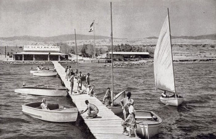
This is a late-1940s photograph from Desert Beach, from the Salton Sea Museum. The caption reads:

Skippers sail trim yachts, not subs, 40 fathoms below the Pacific on California's Salton Sea.

Desert Beach Yacht Club, 241 feet below sea level, welcomed the flyers with burning sands, 95 degree water and warm hospitality. A member of the American Power Squadron, the club holds speedboat races each fall. buoyancy of the salt-packed water makes for record-breaking runs.

Please click the link for a black and white version of Bombay Beach.

The aerial photograph was taken my my friend, Bill Birkemeier, from InTheLens.com. My daughter brought me to this great site (she knows my photographic interests). The ground-level photographs were taken with a Fuji X-E1 digital camera, with RAW files processed with Adobe Camera Raw and DxO Filmpack 3. The zombie-like atmosphere inspired me to experiment with color. The green-tone color frames were created by the cross-process emulation (i.e., E6 film processed in C41 chemicals). The red Volkswagen was faded blue, but with the Kodachrome intensity slider moved to 100%, the colors reversed. Rather cool.

Saturday, July 12, 2014

By the Sea, by the Sea, by the Salty Salton Sea

An air traveler flying east from Los Angeles International Airport flies over the smoggy urban sprawl and gradually ascends over the mountains and desert southeast of the Los Angeles Basin.  Continuing past the San Jacinto Mountains, our intrepid traveler sees to the south a broad basin with a shimmering blue lake, rimmed by mountains. This is the Salton Sea.
The basin where the Salton Sea now sits was once the northern extension of the Gulf of California. Over thousands of years, the Colorado River deposited so much sediment in its delta, it filled the basin and the Gulf retreated southwards. Native Americans occupied the basin 10,000 years ago and left archaeological remains. The Colorado River spilled over into the Salton Basin on numerous occasions over the millennia, creating intermittent lakes, one of which was Lake Cahuilla in 700 A.D.

The present lake was formed in 1901, when the California Development Company, intending to develop agricultural land, dug irrigation canals from the Colorado River. Because of heavy siltation in the canals, engineers created a cut in the western bank of the Colorado to allow more water to reach the valley. But heavy spring flood waters broke through the engineered canal and nearly all the river’s flow rushed into the valley. By the time the breach was closed, the present-day Salton Sea was formed. Historic photographs show a train being derailed by the flood, and H.B. Bell's 1911 novel, The Winning of Barbara Worth, covers this event.  The present lake is about 200 feet below sea level and covers about 380 square miles (from a May 2011 pamphlet by the US Fish & Wildlife Service).
The southern part of the sea is rimmed with dikes, most of which have a road along the top.  South of the dikes are irrigated farmlands.  In the first photograph, the factory in the distance is one of seven CalEnergy geothermal electricity plants. Water is heated by near-surface magma, and deep wells drilled in the geothermal field allow water to come to the surface and power electrical generators. CalSouthern sells the electricity to the grid. This is the same concept used by power plants in Iceland, a nation without oil or gas reserves, but with volcanism and near-surface magma.

The two photographs above were taken from Rock Hill, a volcanic plug that sticks up out of the soft sediments that make up most of the basin.  Rock Hill is in  the Sonny Bono Salton Sea National Wildlife Refuge:
"The Refuge is located within the Pacific Flyway, an important migration route for birds. The Refuge habitats and the Salton Sea are vital to these migrating birds as a resting place and wintering area. The Refuge was established as a sanctuary and breeding ground for birds and other wildlife when 32,766 acres were set aside in 1930."
The refuge was established in 1930 by a Proclamation from President Herbert Hoover. Originally, it consisted of 37,600 acres, but because of flooding by the Salton Sea, now only about 2,200 manageable acres remain (in other words, much of the refuge is under water).
This is an example of farm runoff. It is runoff from agriculture that maintains the Salton Sea, preventing it from evaporating in the hot arid climate. But, the irrigation water leaches salt out of the soil, and, over time, increases the salt content in the Salton Sea.  Currently, the salinity in the Salton Sea is about 44‰ (parts per thousand). To compare with other water bodies, the Pacific Ocean is 35‰, Utah's Great Salt Lake is 280 ‰, the Dead Sea about 210 ‰, and California's Mono Lake is 87 ‰ (from Saltonsea.ca.gov). The major ecological risk is if salinity increases too much, fish will not be able to survive, and the food source for countless migrating birds will disappear.
This is what happens to docks and concrete in contact with the water. Pilings get coated with a rind of salt, and steel is totally eaten away. These photographs were from Bombay Beach, subject of the next essay. You have never seen better urban decay until you have visited Bombay Beach.

Various web sites with scientific and ecological data:
  1. A general summary and overview of ecological problems is at this San Diego State University site.
  2. The State of California has a chronology of events at the Salton Sea
  3. The U.S. Geological Survey has a Salton Sea Science Office with publications and  LIDAR data.
  4. The US Fish & Wildlife Service has a site about the Sonny Bono Salton Sea National Wildlife Refuge.
References

Bell, H.B. 1911.  The Winning of Barbara Worth.  Kessinger Publishing LLC (2010 facsimile reprint, 518p.

The first photograph was taken by my friend, Bill Birkemeier, from InTheLens.com.  The others are with a Fuji X-E1 digital camera, with RAW files processed with PhotoNinja or DxO filmpack.

Sunday, December 15, 2013

Being Restored: the Santa Fe Depot, Redlands, California

The Santa Fe Depot, at 347 Orange Street in Redlands, has been unused for at least three decades. But the building is in reasonably good condition, and, as of 2009, there were ambitious plans to turn it into a combination restaurant and retail space. As of late 2013, I did not see any progress, but these plans typically take years to get going.
Santa Fe Depot, Redlands, California
Originally built by the Atchison, Topeka and Santa Fe Railway, the pseudo Greek revival depot was designed 1909 by architect Arthur Brown, Jr., and constructed in 1910. A nearly 300-foot long colonnade along the platform looks grand, but hides a somewhat more modest 100-foot depot building.  The depot closed in 1970.  The tracks are now owned by the State and may be revived as part of a commuter transit system.  It would make sense to develop rapid rail to connect to Ontario and LAX airports.  
1922 route map of the AT&SF railroad.
Undated photograph from abandonedrails.com.
This was an active depot decades ago, and the 1922 route map shows Redlands as one of the system's many destinations. It must have once been very lucrative to bring passenger traffic to and from southern California.
Santa Fe Depot, Redlands, California
The day I took these photographs, I saw a professional photographer taking portraits here, possibly a corporate job.  He had reflectors to bring light in to his subjects.


The old waiting and baggage rooms look reasonable.  Someone must have repainted in the last few years.  I took these photographs through some dusty windows, bracing the camera on a ledge.
Heavy-duty industrial restroom - built for the ages.
Sturdy old-fashioned restrooms were built to last in the old days. The tiles and stalls surely are original.  I hope this building gets a new life soon.

Articles on other railroad depots:


Wikipedia has a good article on the AT&SF railroad.

For information on the Redlands loop from San Bernardino to Redlands, see the abandonedrails web page.

Photographs taken with a Panasonic G3 digital camera, some RAW files processed with Photo Ninja software.

UPDATE


There train is back! The Redlands - Downtown Metrolink Station is just west of the old depot. Service began on October 24, 2022. You can take the commuter train to Los Angeles. The Metrolink web page provides schedules. 

Thursday, December 12, 2013

A Cornucopia of Preservation: Redlands, California

Regular readers of this blog know I usually record neglect and decay in our cities and towns.  In too many places in America, historic houses and commercial buildings have been neglected, torn down, and replaced with nasty, cut-rate, build-it-cheap structures. Optimize cash flow today and forget about our legacy to future generations. Have you seen the 25+ miles of cul-de-sacs and McMansion ghettos as you fly into Hartsfield Airport in Atlanta? Have you seen the ghastly typical strip outside of a small town? What happened to pride in our towns and nation?

But this time, I want to show you that the opposite is possible: urban preservation.  Redlands, California, a bedroom community about 60 miles east of Los Angeles, is the "Jewel of the Inland Empire." 
The streets in the historic district are planted with spectacular palms.  From Wikipedia, "At the turn of the 20th century, Redlands was the "Palm Springs" of the next century, with roses being planted along many city thoroughfares. Some of these plantings would survive as wild thickets into the 1970s, especially adjacent to orange groves where property management was lax. Washingtonia palms (Washingtonia robusta) were planted along many main avenues. In fact, Redlands was the first city to have center medians with trees or gardens in between roads. So beautifully kept was the area, with the dramatic mountain backdrops, that for several years the Santa Fe Railroad operated excursion trains along the loop that passed through the orange groves of Redlands and Mentone, across the Santa Ana River, and back into San Bernardino via East Highlands, Highlands and Patton…"
1908 panorama of Redlands, California
The 1908 panorama shows the rows and rows of orange and grapefruit trees. This was a major commodity in the early 20th century, made possible by an efficient railroad infrastructure and a complex water system, which allowed irrigation in this semi-arid setting.

The historic district south of Interstate 10 and the hills south of town have retained the garden city look. Unfortunately, most of the orange groves are gone, but a few small ones remain, and the town has a lush profusion of exotic plants.  Most are introduced species, of course, but cheap water makes the green lawns and beautiful flowers possible.

It is an eye-opener to visit a city like Redlands with its collection of early 20th century houses in amazing condition.  Several factors must have contributed:  

  • The climate: Redlands is dry, and wood does not rot as rapidly as in wetter areas. 
  • Residents lived in their historic houses, precluding a large-scale conversion to rentals.
  • They were wealthy enough to maintain their houses properly over the decades. 
  • The city may have been wise enough to offer incentives to maintain the historical areas.  
  • The city may have had strict zoning.
  • Somehow Redlands avoided the scourge of white flight (for an extreme example, see Detroit).
  • And most important, the residents had pride.  
Cajon Street from East Vine, view southeast.
In 1908, you would have taken the train to the Santa Fe depot (subject of a future blog article) and walked south on Orange Street. Orange turns into Cajon Street, and at the corner of East Vine, you reach the police station, library, churches, and other civic buildings. Proceed southeast, and elegant houses line the road.
215 Cajon Street. Note the arch-topped inset balcony on the third floor.
A professional office at 256 Cajon Street.
425 Cajon Street, another property with lush vegetation.
504 Cajon Street.  Cool tower sticking out of the roof, and handsome wrap-around porch.
513 Cajon Street, a bit more severe than the previous examples, but with a distinctive dormer on the third floor.
523 Cajon Street.  A handome Victorian with a wrap-around porch.
633 Cajon Street.  Note the amazing tree house.
726 Cajon Street.
734 Cajon Street. Flowers and an amazing cactus under the tree.
755 Cajon Street, Spanish style in a somewhat severe interpretation. 
928 Cajon Street, another example with a great corner tower and dormer window.  This is almost a mirror image of 504. And this one has rose trees...
1004 Cajon Street, an impressive Victorian in immaculate condition. I love the corner tower.
These are just some of the houses on Cajon Street. See the captions for the addresses.
Olive was another elegant residential street. One of the more unusual homes is at 405 West Olive. This exuberant pseudo-Moorish design was (is) a bit over the top, but it fits in the Southern California setting. It was built in 1903 for William F. Holt, a St. Louis developer and capitalist. One of its unusual features is a 1-lane bowling alley in the basement.  Many of Redlands' finer homes were built in the turn of the century by wealthy easterners, who came to southern California in the winter months to escape snow and pollution.
Olive Apartments, 24 West Olive Avenue.  Notice the repeating theme of the arches.
316 West Olive Avenue.  Elegant wood house with detail woodwork on the balcony.
533 West Olive Avenue.  Arts and crafts cottages like this are common in Redlands.
501 West Olive Avenue.
West Olive Avenue, running northeast to southwest, is a prestigious residential street.
Alvadaro Street.  I have seen handsome houses like this in Pittsburgh and other eastern cities. Note the impressive clay tile roof and the balcony-dormer.
621 Alvarado Street, surrounded by the lush vegetation.
Alvarado Street. A ranch style with immaculate garden.
Alvarado Street.  A large version of an Arts and Crafts cottage. The pillars made of river rock are seen in many houses here.
Alvarado street runs from Smiley Park at West Olive southeast to Prospect Park.
103 South Beuna Vista Street.
105 South Center Street
Close by are South Center and South Buena Vista Streets, also with nicely-maintained properties.

511 Linda Place
623 Linda Place
Linda Place has somewhat more modest cottages, many in immaculate condition.
604 Linda Place, with drought-tolerant plants instead of lawn.
604 Linda Place, with unusual river rock walls but no posts - the roof cantilevers out over the porch.
This is an amazing:sight: mahogany tongue-and-groove flooring.  

The unusual kitchen tiles that show early 20th century advertisements from the citrus packers.

A recent Redlands home-buyer documents her adventures in her Time-Axis blog. You can read about lead paint over the ages and similar topics.  Click the link to see the Santa Fe depot in Redlands. 


This is a portal for the Inland Empire, the area east of Los Angeles. It was once a lush paradise of citrus farms, but now much has been despoiled by suburban sprawl and industry.


Photographs taken with a Panasonic G3 camera, most with the 20 mm f/1.7 Lumix lens.  Raw files reprocessed with PhotoNinja.