Showing posts with label architecture. Show all posts

Tuesday, August 15, 2017

Ugly Buildings in Seoul, Korea

[Guest post by morangm]

Kodachromeguy asked me to contribute a post to his urban decay blog after my recent trip to Seoul, South Korea. Seoul isn't decaying. Very much not so!  But it's a very ugly city with a lot of very ugly buildings. Hopefully readers of this blog will enjoy my photos (which undoubtedly don't match Kodachromeguy's usual quality standards) and my descriptions of Seoul.

Today, the Seoul metropolitan area is home to about 25 million people, which is about half the population of South Korea.  (For comparison, the greater Los Angeles region, a geographic area far, far larger than Seoul, has only about 15 million.)  The Korean people picked themselves up by their bootstraps after the Korean War (1950-1953) and went from being one of the world's poorest countries to being one of the richest in just 50 years or so, transforming into a world leader in technology and culture with a very high standard of living.

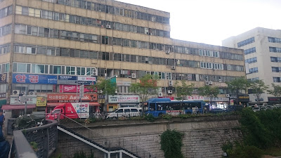
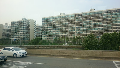
Despite this impressive development record, Seoul is a very ugly city.  The city is densely packed with nearly-identical high-rise apartment blocks and a mish-mash of other concrete rectangles, very few of which seemed to have benefited from the services of an architect.  The city seems to function very, very well, and efficiently, but it's certainly not inspiring to look upon.
View of Seoul from Inwangsan
View from the historic Seoul City Wall on Inwangsan mountain showing vast swaths of identical high-rise apartments.

Modern Seoul was built in a hurry. Some 1.2 million people died in the Korean War, a conflict which obliterated a great deal of infrastructure and left the country divided.  After the war, massive amounts of housing and other basic infrastructure were the top priority.  The following decades also saw large amounts of rural-to-urban migration, spurning on the need for still more rapid building.  It's no wonder there was little room for aesthetic considerations.

These quickly-built, now-older areas of the city have some really awful beat-up buildings, all still in use. (There's no room in Seoul for empty buildings or vacant lots.  Every inch of space is used.)
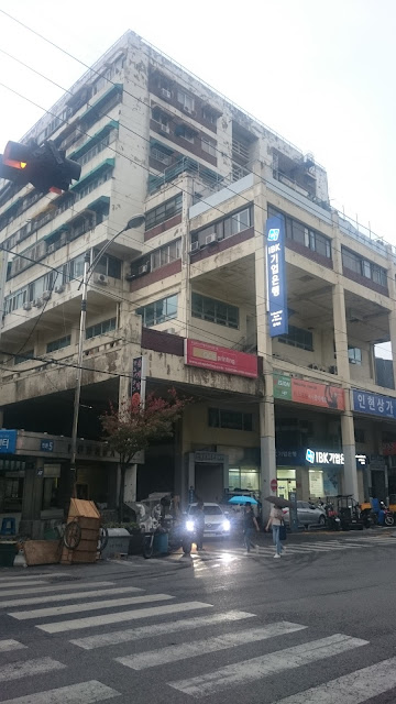
Ugly building in Myeongdong, central Seoul
Possibly the ugliest building I've ever seen (Myeongdong, central Seoul)

Ugly building near Dongdaemun
A wholesale market building down the street from the Dongdaemun Design Plaza
Older neighborhood near Digital Media City
An older neighborhood "ripe" for gentrification, across the tracks from the brand new Digital Media City development
Ugly triangle-shaped building
From the same neighborhood

Ugly apartments overlooking the Han River
Believe it or not, these lovely apartments have a gorgeous view of the Han River!
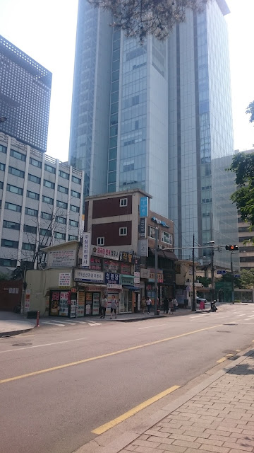
Gentrification is definitely ongoing. It's not unusual to see a new glass-and-steel skyscraper dwarfing a clump of older buildings.
Juxtaposition of old and new buildings in central Seoul
Old and new buildings, downtown Seoul
However, even now, aesthetics doesn't seem to be a priority.  I read through a summary of Seoul's master plan for a class I was taking, and there was nothing at all about aesthetics, design, or beautification.  Contrast this to, say, Toronto, another city I studied for a class.  In Toronto, a complex and very specific zoning code controls the height and setbacks of buildings to make sure that streets don't feel like crevices and to ensure that people have nice viewsheds from the upper floors of buildings.  There appear to be no such codes in Seoul.

That said, some of the newer areas do look a little nicer.  For example, Digital Media City, a government development project to put media and entertainment companies in a sparkling new neighborhood, had some buildings that looked like they had actually been designed and some top-notch public art.
Public art in Digital Media City
Public art in Digital Media City: "Square-M, Communication" by Yoo Young-ho
The Seoul government has also put a lot of effort into a couple of showcase projects, such as the restoration of the Cheonggyecheon Stream.  The stream was important in the early days of Seoul, but after the Korean War, it became very polluted and the site of lots of homeless encampments, so they covered it over with a highway.  In the early 2000s, they removed the highway and restored the stream into a very pleasant public park that spans much of the heart of the city.

The stream begins with a fountain and a little artificial waterfall right in the city center and then travels in a nicely-landscaped concrete channel for several miles before emptying into the Han River. Either the historic water source of the stream was always intermittent, or else it's been too disrupted by other construction (of the metro and such) to provide adequate water for the stream now, so Han River water is actually pumped to supply the stream water.  It's fantastic as a park, and it's beautiful, but its ecological value is debatable.  It's certainly not "natural", but it's also probably a lot better than a highway.
Cheonggyecheon Stream near Dongdaemun
The restored Cheonggyecheon Stream near Dongdaemun
Because Kodachromeguy always does this: All photos were taken with a Sony Xperia Z3 Compact smartphone with a lens cover that is a little messed up.
Thursday, December 12, 2013

A Cornucopia of Preservation: Redlands, California

Regular readers of this blog know I usually record neglect and decay in our cities and towns.  In too many places in America, historic houses and commercial buildings have been neglected, torn down, and replaced with nasty, cut-rate, build-it-cheap structures. Optimize cash flow today and forget about our legacy to future generations. Have you seen the 25+ miles of cul-de-sacs and McMansion ghettos as you fly into Hartsfield Airport in Atlanta? Have you seen the ghastly typical strip outside of a small town? What happened to pride in our towns and nation?

But this time, I want to show you that the opposite is possible: urban preservation.  Redlands, California, a bedroom community about 60 miles east of Los Angeles, is the "Jewel of the Inland Empire." 
The streets in the historic district are planted with spectacular palms.  From Wikipedia, "At the turn of the 20th century, Redlands was the "Palm Springs" of the next century, with roses being planted along many city thoroughfares. Some of these plantings would survive as wild thickets into the 1970s, especially adjacent to orange groves where property management was lax. Washingtonia palms (Washingtonia robusta) were planted along many main avenues. In fact, Redlands was the first city to have center medians with trees or gardens in between roads. So beautifully kept was the area, with the dramatic mountain backdrops, that for several years the Santa Fe Railroad operated excursion trains along the loop that passed through the orange groves of Redlands and Mentone, across the Santa Ana River, and back into San Bernardino via East Highlands, Highlands and Patton…"
1908 panorama of Redlands, California
The 1908 panorama shows the rows and rows of orange and grapefruit trees. This was a major commodity in the early 20th century, made possible by an efficient railroad infrastructure and a complex water system, which allowed irrigation in this semi-arid setting.

The historic district south of Interstate 10 and the hills south of town have retained the garden city look. Unfortunately, most of the orange groves are gone, but a few small ones remain, and the town has a lush profusion of exotic plants.  Most are introduced species, of course, but cheap water makes the green lawns and beautiful flowers possible.

It is an eye-opener to visit a city like Redlands with its collection of early 20th century houses in amazing condition.  Several factors must have contributed:  

  • The climate: Redlands is dry, and wood does not rot as rapidly as in wetter areas. 
  • Residents lived in their historic houses, precluding a large-scale conversion to rentals.
  • They were wealthy enough to maintain their houses properly over the decades. 
  • The city may have been wise enough to offer incentives to maintain the historical areas.  
  • The city may have had strict zoning.
  • Somehow Redlands avoided the scourge of white flight (for an extreme example, see Detroit).
  • And most important, the residents had pride.  
Cajon Street from East Vine, view southeast.
In 1908, you would have taken the train to the Santa Fe depot (subject of a future blog article) and walked south on Orange Street. Orange turns into Cajon Street, and at the corner of East Vine, you reach the police station, library, churches, and other civic buildings. Proceed southeast, and elegant houses line the road.
215 Cajon Street. Note the arch-topped inset balcony on the third floor.
A professional office at 256 Cajon Street.
425 Cajon Street, another property with lush vegetation.
504 Cajon Street.  Cool tower sticking out of the roof, and handsome wrap-around porch.
513 Cajon Street, a bit more severe than the previous examples, but with a distinctive dormer on the third floor.
523 Cajon Street.  A handome Victorian with a wrap-around porch.
633 Cajon Street.  Note the amazing tree house.
726 Cajon Street.
734 Cajon Street. Flowers and an amazing cactus under the tree.
755 Cajon Street, Spanish style in a somewhat severe interpretation. 
928 Cajon Street, another example with a great corner tower and dormer window.  This is almost a mirror image of 504. And this one has rose trees...
1004 Cajon Street, an impressive Victorian in immaculate condition. I love the corner tower.
These are just some of the houses on Cajon Street. See the captions for the addresses.
Olive was another elegant residential street. One of the more unusual homes is at 405 West Olive. This exuberant pseudo-Moorish design was (is) a bit over the top, but it fits in the Southern California setting. It was built in 1903 for William F. Holt, a St. Louis developer and capitalist. One of its unusual features is a 1-lane bowling alley in the basement.  Many of Redlands' finer homes were built in the turn of the century by wealthy easterners, who came to southern California in the winter months to escape snow and pollution.
Olive Apartments, 24 West Olive Avenue.  Notice the repeating theme of the arches.
316 West Olive Avenue.  Elegant wood house with detail woodwork on the balcony.
533 West Olive Avenue.  Arts and crafts cottages like this are common in Redlands.
501 West Olive Avenue.
West Olive Avenue, running northeast to southwest, is a prestigious residential street.
Alvadaro Street.  I have seen handsome houses like this in Pittsburgh and other eastern cities. Note the impressive clay tile roof and the balcony-dormer.
621 Alvarado Street, surrounded by the lush vegetation.
Alvarado Street. A ranch style with immaculate garden.
Alvarado Street.  A large version of an Arts and Crafts cottage. The pillars made of river rock are seen in many houses here.
Alvarado street runs from Smiley Park at West Olive southeast to Prospect Park.
103 South Beuna Vista Street.
105 South Center Street
Close by are South Center and South Buena Vista Streets, also with nicely-maintained properties.

511 Linda Place
623 Linda Place
Linda Place has somewhat more modest cottages, many in immaculate condition.
604 Linda Place, with drought-tolerant plants instead of lawn.
604 Linda Place, with unusual river rock walls but no posts - the roof cantilevers out over the porch.
This is an amazing:sight: mahogany tongue-and-groove flooring.  

The unusual kitchen tiles that show early 20th century advertisements from the citrus packers.

A recent Redlands home-buyer documents her adventures in her Time-Axis blog. You can read about lead paint over the ages and similar topics.  Click the link to see the Santa Fe depot in Redlands. 


This is a portal for the Inland Empire, the area east of Los Angeles. It was once a lush paradise of citrus farms, but now much has been despoiled by suburban sprawl and industry.


Photographs taken with a Panasonic G3 camera, most with the 20 mm f/1.7 Lumix lens.  Raw files reprocessed with PhotoNinja.

Saturday, December 17, 2011

Hoben's Country Store, Old Hwy. 27 and Warriors Trail, Vicksburg, MS


This traditional wood-frame country store is at the junction of Old Highway 27 and Warriors Trail, southeast of Vicksburg. A decade or two ago, it was still open for business, but I am not sure when it closed. Possibly a reader can provide some information. Somewhere in my files, I may have a Kodachrome slide of this store in operation.

At one time, small locally-owned stores like this were found along rural roads throughout the south because rural farm workers did not have cars and had to walk or ride a wagon to get supplies. Needless to say, they are a dying institution, and the remaining examples are falling down, burning, or being torn down.

The roof on the main building is still intact, and it looks like the owners have been storing miscellaneous junk for awhile. Notice the wood boards forming the interior walls. Ultimate fate: unknown.

(Photographs taken with a Panasonic G1 digital camera with 14-45 mm Lumix G Vario lens, ISO 100, December 17, 2011.)

Monday, January 25, 2010

Naval Reserve Center, 181 Jefferson Street, Jackson, MS


Just west of the Mississippi State Fairgrounds, there is a distinctive blue and white building at 181 Jefferson Street. The Reserve Center, with its ship-like façade, opened in 1949 as a training facility for the Navy and Marine Corps. According to the Mississippi Heritage Trust (which has a very interesting web page: http://www.mississippiheritage.com/list07.html ), the center was designed by architect John L. Turner.

The building was last used in 2000. It belongs to the City of Jackson and appears to be deteriorating quickly. It's sad because I think the architect was very successful at linking the building's design with its purpose and evoking a sense of the sea.