Showing posts with label New Mexico. Show all posts

Friday, July 27, 2018

Travels on the Mother Road, Route 66: Part 12, Las Vegas, New Mexico

Santa Fe was very interesting. But it is time to continue our trip on Route 66. Press the clutch, put the gear in first, and head southeast.
Bridge Street, Las Vegas, New Mexico
Las Vegas (the town in New Mexico, not the gambling mecca of Nevada) is east of Santa Fe and was not directly on the 1920s version of Route 66. But a short side trip is rewarding because of its amazing western architecture. The town of Las Vegas was founded in 1835, but the area had been inhabited for four centuries by native Americans, Anglos, Spanish conquistadores, robber barons, and gangsters. The town is an architectural treasure, and boasts more than 900 buildings on the National Register of Historic Places.
Prosperity came to Las Vegas in the late 1800s via the Atchison, Topeka, and Santa Fe Railroad, which built significant rail infrastructure in town. This included a handsome mission-style depot. This now serves as the Las Vegas-San Miguel Chamber of Commerce.
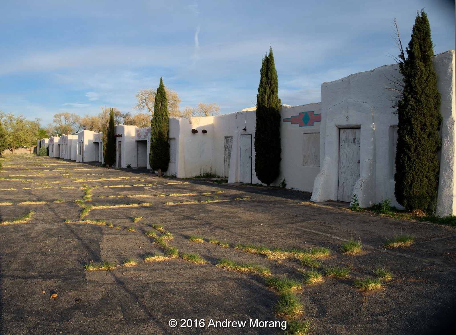
The now-closed La Castaneda is a former Harvey House (hotel). This is described as early mission revival style. The Harvey Houses were a well-respected institution along the rail lines in the US southwest. According to Wikipedia,

Before the inclusion of dining cars in passenger trains became common practice, a rail passenger's only option for meal service in transit was to patronize one of the roadhouses often located near the railroad's water stops. Fare typically consisted of nothing more than rancid meat, cold beans, and week-old coffee. Such poor conditions understandably discouraged many Americans from making the journey westward.
The subsequent growth and development of the Fred Harvey Company was closely related to that of AT&SF. Under the terms of an oral agreement, Harvey opened his first depot restaurant in Topeka, Kansas in January 1876. Railroad officials and passengers alike were impressed with Fred Harvey's strict standards for high quality food and first class service. As a result, AT&SF entered into subsequent contracts with Harvey wherein he was given unlimited funds to set up a series of what were dubbed "eating houses" along most of the route. At more prominent locations, these eating houses evolved into hotels, many of which survive today. By the late 1880s, there was a Fred Harvey dining facility located every 100 miles along the AT&SF.

Manu of the Harvey Houses featured spectacular architecture. The El Rancho in Gallup, where I stayed on my 2016 Route 66 trip, was not a Harvey House.
Many of the old stores on Bridge Street have been repainted, but I am not sure how many are occupied. 
In the southeast part of town, off US 85, also known as the CanAm Highway, I found an intact roundhouse. Many of these around the country have been town down, so it is rewarding to see an intact example. The turntable was gone. I think a trucking company used the roundhouse for truck storage.

Las Vegas was a decent overnight stop. From here, we proceeded south and then east on Route 66.

Photographs are from an Fujifilm X-E1 digital camera with various Fuji lenses.

Saturday, July 21, 2018

Travels on the Mother Road, Route 66: Part 11, Santa Fe, New Mexico

Dear Readers, let us return to the Mother Road, the famous Route 66. When it was originally mapped out in the mid-1920s, Route 66 entered Santa Fe from the south after leaving Albuquerque. It then headed east and southeast through the mountains. But in 1937, Route 66 was rerouted to bypass Santa Fe (political posturing - who would have guessed?). Today, a traveler today can choose to travel on the older original 1920s routing or just drive east-west through Albuquerque. Regardless, Santa Fe, the capital of New Mexico, is one of the oldest cities in the Unites States and is ripe with interesting architecture, the arts, a famous opera, and cultural activities. The Georgia O'keefe Museum is amazing. My pictures below are a semi-random view of town. The standard tourist sites have been photographed millions (billions?) of times; I don't need to repeat them.
New Mexico Museum of Art, West Palace Ave.
Maria's Kitchen, West Cordova Ave.
Coming from parts of the country with predominantly wood architecture, I found the adobe architecture of New Mexico to be very interesting. It is ideally suited to the hot summers because the thick clay walls keep the blazing sun at bay.
Spanish festival, Sanat Fe Plaza
There is no end to cultural activities and fun. The Santa Fe Plaza has been the social, commercial, and political center of the city since about 1610 (remember, this is one of of the oldest cities in the United States, only matched by St. Augustine in Florida). The Plaza is a National Historic Landmark.
Glass fruit at the famous 109 East Palace Ave.
Just off the Plaza is a block of 1600s adobe buildings. One of these was the security and clearing office for the Los Alamos scientists and engineers during the early phase of the Manhattan project in World War II. Newly-arrived workers entered a perfectly ordinary-looking door and met the formidable Ms. McKibbin, who issued their passes. Then they exited out the rear to a bus, which took them up into the mountains to the new Los Alamos facility. From the Atomic Heritage Foundation:
After arriving in Lamy, the scientists, SEDers, and families were directed to 109 E. Palace Avenue in Santa Fe. The building, constructed as a Spanish hacienda in the 1600s, is located just off the plaza in downtown Santa Fe. During World War II, it was the administrative hub of the Manhattan Project.  
Dorothy Scarritt McKibbin was the first reassuring face the fatigued newcomers saw. At 109 East Palace, McKibbin informed them that their journey continued another 35 miles along the winding road up to the Pajarito Plateau. In the early months, she dispatched an average of 65 people each day to “the Hill,” as Los Alamos was called. The steady stream of arrivals meant the office was often “bedlam,” as McKibbin described it. She issued passes and IDs and directed newcomers to their homes, received shipments of household items to be distributed to the Hill’s residents, and tended to personal matters as needed.  McKibbin was the perfect person for her job and quickly became indispensable as the “Gatekeeper” at 109 E. Palace Avenue and a close friend and confidante of Oppenheimer. She had a warm smile, an engaging personality and was reassuringly calm and efficient. In recognition of her contribution, McKibbin was awarded the title of “First Lady” of Los Alamos and declared a Living Treasure of Santa Fe. 
Today, 109 E. Palace houses gift shops and sells glass fruit and other artsy items.
A family friend generously let us stay in his guest cottage. He has interesting items in his yard, along with resident bunnies.
Aspen Vista trail, approx. 10,600 ft altitude, Nexus 4 frame reprocessed with DxO FilmPack 5.
Buy a hiking guidebook and try some of the trails around Santa Fe. Many are less than a hour from town.
Valles Calders National Preserve, Olympus Trip 35 exposure on Kodak BW400CN film.
Head north into the mountains to the Valles Caldera National Preserve (established by president Clinton, part of the National Park Service). The high altitude air is clear and crisp. View this ancient supervolcano and watch elk grazing in the pastures. Listen to the silence (except when some Harleys come thundering along).
The composer, Igor Stravinsky, conducted regularly at the Santa Fe Opera from 1957 to 1962. This bust is on the Stravinsky Terrace of The Santa Fe Opera. The opera, on a stunning site north of town, is a fabulous venue for top-class opera. Make a point to attend a performance!

Santa Fe and the surrounding mountains are a fantastic vacation destination, highly recommended!

The square photographs are from Tri-X 400 film in a Hasselblad camera. The rectangle frames are Kodak BW400 film from a Yashica Electro 35CC camera (a convenient travel camera with a top-quality 35mm f/1.8 Color-Yashinon lens). The view of Valles Caldera was taken with a Olympus Trip 35 camera with a polarizer to emphasize the clouds. You can click any frame to see the larger photograph.

Monday, October 16, 2017

Travels on the Mother Road, Route 66: Part 10a, Return to Kasha-Katuwe Tent Rocks National Monument, New Mexico

Dear Readers, I drove another piece of Route 66 in 2017, from Santa Fe, New Mexico, to Tulsa, Oklahoma. We will continue our tour of the Mother Road with a short return hike in the amazing Kasha-Katuwe Tent Rocks National Monument. Archaeologists have documented evidence of 4000 years of human habitation in the region. This implies a dependable water supply throughout the year. The Peublo de Cochiti people still inhabit the surrounding area. My trip was in July, the "monsoon" season in New Mexico, and the skies were amazing with towering thunderheads. Also, this time, I used black and white film instead of digital.
The Slot Canyon Trail is an easy way to get the feel of the desert, rock formations, and views. From a parking at about 5,200 ft altitude, you gradually ascend across dusty desert and enter a narrow slot canyon. You wind your way through the narrow canyon with vertical walls, and then ascend to the plateau at about 6,300 ft. The last part is steep but well-marked. The trail ends at an overlook of the Monument’s teepee (or tent) shaped rock formations.
As I wrote before, these teepees remind me of the cones of tuffa in Cappadocia, in central Anatolia (Turkey). Read more about the geology at the New Mexico Bureau of Geology & Mineral Resources.
The bent-over and weathered trees are especially interesting.
Late afternoon, and the lightning crackles in the distance, and the thunders rumbles. The signs warn you about flash floods. But the tourists were still coming in and heading to the slot canyon.

I took these photographs with my Yashica Electro 35CC camera (with 35mm f/1.8 Color-Yashinon lens) using Kodak BW400CN film. I scanned the negatives with a Plustek 7600i scanner. Note, in the 1970s, the word "color" was applied to all sorts of optics to demonstrate that they were so superior, you could use them for color film. Brilliant. Today, the marketers would use the word "digital" instead. Or maybe they would use "nano."

Thursday, May 18, 2017

Travels on the Mother Road, Route 66: Part 10, the Kasha-Katuwe Tent Rocks National Monument

At one time, Route 66 extended between Santa Fe and Albuquerque. As far as I can tell, today there are few 66 remains between the two cities. But my Santa Fe friends told me about a spectacular geological place to visit. A short distance northwest of I-25 (which gobbled up much of Route 66) is the Kasha-Katuwe Tent Rocks National Monument, an terrain of rock pinnacles, cones, and narrow canyons. President Bill Clinton established the Monument in January, 2001. It is operated by the Bureau of Land Management (BLM), and if you have a National Parks pass, you can access the rocks without additional fee. According to Wikipedia, "Kasha-Katuwe means "white cliffs" in the Pueblo language."
This rugged terrain of weathered spires and pinnacles was created by layers of volcanic rock and ash deposited by pyroclastic flow ("a dense, destructive mass of very hot ash, lava fragments, and gases ejected explosively from a volcano and typically flowing downslope at great speed") from an explosion about 6 or 7 million years ago from the Jemez volcanic field. Since then, weathering (chemical or mechanical deterioration of rock material) and erosion (movement of rock material by water, wind, or ice) of these relatively soft layers has created the canyons and tent rocks. The tent rocks are cones of pumice or tuff upon which a cap of harder rock has remained, almost looking like some giant hand must have balanced it on the cone below.
The pines cling to the rocks with roots reaching down into cracks to find water.
Yes, the Slot Canyon trail goes through this slot.
There are a number of hiking trails. They are not too rugged: you can do them with running shoes. But better not use flip-flops, as some tourists demonstrate (hint: there are rattlesnakes). Wear a wide-brimmed hat and take water. The Slot Canyon trail makes for a nice 3 or 4 hour outing.
 Uchisar, Cappadocia, Turkey (Rolleiflex 3.5E film photograph)
The only other place I know of with similar cones and spires of volcanic tuff and ash is in Cappadocia, in central Anatolia, Turkey. The Goreme area of Cappadocia was settled by early Christians, who carved homes, churches, and entire towns into the soft rock. First visit Kasha-Katuwe, then go to Cappadocia (but I will admit, I did it in the opposite order). Both are astonishing scenic and cultural wonders.

Dear Readers, this is the last of my 2016 Route 66 posts. Thank you for riding along.

Thursday, May 11, 2017

Travels on the Mother Road, Route 66: Part 9, Albuquerque, New Mexico

Dear readers, it is time to complete the story of my 2016 west-to-east excursion on the Mother Road. 

Albuquerque, New Mexico, was always a major stopping point for travelers on Route 66. It was the "big city," with motels, movies, entertainment, groceries, and repair services. Coming in from the west from the Pecos River crossing, Route 66 merged with or became Central Avenue, a major east-west corridor through town. The western outskirts were lined with motels to serve the weary 66 traveler. 


Entering town on Central Avenue, the El Vado was ready to welcome visitors with a comfortable room and a place to park their car. Open since 1936, it had recently closed when I drove by in April of 2016. Had millions really stayed there as per the sign? Regardless, the units looked to be in good condition, so I do not know why they closed. Many of these Route 66 motels were built in Mission Style with tile roofs, protruding timbers, and white painted stucco walls. They were clearly meant to evoke the the "old west" as well as emulate the popular Alamo Plazas, which were America's first motel chain, founded by a Waco, Texas hotelier, Mr. Edgar Lee Torrance. The Mission Revival Style was an architectural movement which was inspired by the late 18th and early 19th century Spanish missions in California.


Other lodgings, like this 21 Motel at 2411 Central Avenue, were still in business, but had a distinctly dive ambience (I passed). 
 

Route 66 continued east into downtown, In my short stopover, it looked like much of the inner core of the city is pretty dumpy, but Central Avenue has been partly revived and gentrified. The merchants were certainly capitalizing on the Route 66 theme.


Some of the stores have spectacular examples of western art (OK, western kitsch) in their architecture.


The famous KiMo Theatre at 423 Central Ave. NW is restored and operational. It was built in 1927 in an extravagant "Art Deco-Pueblo Revival Style" (I did not know such a style existed). As an example of the decorative elements, look at the handsome door handles. The KiMo is a popular site for paranormal investigators. The KiMo is reputed to have a ghost.


Near the KiMo, you see traditional 1920s office blocks interspersed with newer construction. Along Central Ave., they have been cheerfully painted and adorned with plenty of Route 66 signs.

Dear Readers, we will have one more article, and then that will be it for my 2016 trip on the Mother Road. Thank you for reading along. Next road trip: the Mother Road in the Great Plains. And next time, I will use black and white film.

Sunday, January 8, 2017

Travels on the Mother Road, Route 66 - Part 8, Western New Mexico

Let's continue our drive along The Mother Road, Route 66, into New Mexico, the "Land of Enchantment." Crossing the border from Arizona to New Mexico, I was running short on time and could not follow all sections of old 66. In many areas, 66 followed the frontage road paralleling Interstate 40 - I think the original pavement is gone. I headed to Gallup to find a hotel.
The famous El Rancho Hotel is still in business. The western motif is possibly a bit over-the-top, but this is Route 66, and the El Rancho really does ooze the ambiance of the old west, glamour, and movie stars. Numerous stars stayed here while filming classic westerns during the 1930s and 1940s, and guest rooms are labeled with their names rather than numbers. Today, European and Asian tourists love the place.
It would be hard to find a more exuberant lobby than this amazing timber and portrait-filled space with two stately curving wood stairs leading up to the rooms. There is a tiny elevator off to one side, and the desk clerk needs to operate it with a manual lever. I wonder if they once had a fellow dressed as an Indian Chief run the lift?
They assigned me to the Lorraine Day room, which was cosy. The compact bathroom had a tub and plumbing fittings similar to the ones in our 1920s house. The restaurant in the El Rancho is not very inspiring.
Unfortunately, the rest of Gallup is uninspiring, as well. Other than the El Rancho, the other lodgings looked rough. In the morning, I packed up and departed.
I had to push on and continued east. Wow, many people drive 90 mph along Interstate 40. At high altitude, I had to push the old Volvo hard - pedal to the metal. Fortunately, I was able to find gasoline stations with 100% gasoline (meaning no ethanol), which runs better in European cars that predate the ethanol boondogle.
The "top of the world" is the North American Continental Divide, here at an elevation of 7,245 ft (2,208 m).
This map shows the western continental divide, generated from various data sources at ArcGIS.com (hosted by Esri  (a.k.a. Environmental Systems Research Institute)). West of this dividing line, rainfall flows to the Gulf of California or Pacific Ocean, while rainfall to the east makes its way into the Mississippi River basin and, eventually, to the Gulf of Mexico. In Arizona and west New Mexico, although water flows into the Colorado River, very little reaches the Gulf of California because most is diverted along the way for agriculture and urban use.
Continuing east, I reached Grants, a town in Cibola County, about 80 miles west of Albuquerque. The old Swap Meet had not been swapping for many years.
The pawn shop was a bit more active, with plenty of "old-fashioned" stuff to give it the antique look. The Continental Divide Trail passes near here, and many through hikers pick up supplies or rest in Grants.
The historic Rio Puerco bridge, crossing the Rio Puerco, was built in the 1930s under a program funded by President Roosevelt's administration. It is a Parker truss design bridge, common in the 1920s and 1930s. Interstate 40 now carries traffic across the valley, and this old bridge is for pedestrian use only.

Next stop: Albuquerque.

Photographs taken with a Fuji X-E1 digital camera with various lenses. I broke my Fuji film camera earlier in the trip and therefore could not take real photographs with black and white film.