Showing posts with label shotgun shack. Show all posts

Tuesday, March 18, 2014

More Pearl Street Cottages, Vicksburg, Mississippi: 2014

Long-term readers may remember my 2010 essay on cottages of Pearl Street, Vicksburg. A notice in the Vicksburg Post about a house that had been condemned inspired me to revisit Pearl Street. The news is bad: many houses have been razed, and many of the remaining are in poor condition. This once-vibrant community is simply crumbling away.  Let's start at the north and work our way south, with house numbers increasing. This is a long article with plenty of houses to cover. You will see recent photographs along with scans of Kodachrome slides from the 1980s and 1990s.
The railroad has always run parallel to Pearl Street, at least since the Civil War. This is the main line to Jackson. The 2005 photograph is from the new embankment, which cuts across land once owned by Vicksburg Lumber Company. The railroad bought it to reduce the radius of the curve as the trains turn east to go under the Washington Street tunnel.
2000 Pearl Street, 2004 (Kodachrome slide).
The first house on our tour is No. 2000.  This is the west side of the street, where the land drops off steeply down to the railroad yard a few hundred meters further west.  Therefore, the rear of most of these west houses are supported on stilts.

The little house at 2004 was condemned, according to a January 7 article in the Vicksburg Post. The City had been unable to locate the owner, and the inspector deemed it a hazard. Notice in the third photograph, the far wall beyond the door has been totally eaten by termites. By February 22 (2014), the house was gone.This is how we have lost so much housing over the last two to three decades: the place deteriorates, the owner is gone and cannot be located, and the city is forced to raze the unit and take ownership of the parcel. Then the property no longer generates tax revenue.
Next on our tour is this house at 2014. As of February 2014, it was still standing.
This is no. 2114, with an awning and asphalt siding shingles. This house also was standing in 2014.
No. 2118 is occupied and in fair condition.
2123 Pearl Street
A bit further south on the east (opposite) side of the tracks is 2123. It is empty, status unknown.
This big mansion is at 500 Klein Street. It was once a tour home but may be for sale now.
Also on the east side, a set of small cottages. This is No. 2213.
The little yellow shotgun is No. 2215.
No. 2217 is almost identical, except for the porch having siding.
The last of the group is No. 2219.  All of these were occupied as of February, 2014.

Moving on to the 2300 block, this little store was at 2328 Pearl. Now it is a dull brown paint and unused.
Located across the street from 2328, this pink unit at 2410 may have also been a store. As I recall, it has been empty for years but is in reasonable condition. It is interesting to consider that there were once enough residents to support two neighborhood groceries.
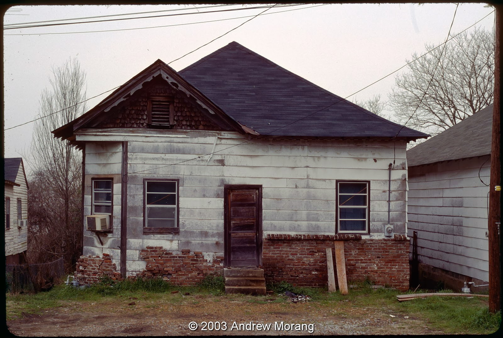
 No. 2414 is a cottage, occupied in 2003.
No. 2416 had a home-made brick half facade.
No. 2418 was in poor condition in 2003, and is gone now.
No. 2420 was a duplex. I think it is also gone now.
Up on the east side was no. 2421, in poor condition in 2003, and demolished soon after.
The next house on the east side, 2423, was also in poor condition in 2003.  It, too, is gone.
Back on the west side, no. 2424 was painted and sound.
No. 2426 was a cheerful little place with a couch out front.
No. 2428 was another blue house (at least in 2003). Notice that in the 1993 photograph above, it was pink.
The house at 2430 was the last on the west side of the tracks. Further south (to the left in the photograph), the land drops off steeply. Possibly years ago there were more houses on stilts, but I do not remember them.
These were my basketball buddies from 2002. I wonder where they live now?
This yellow house at 2504 is unusual in that it is made of cinder-block. It is empty now.
No. 2508 was on the west side and was condemned as of 2003.
Across the street on the east side was No. 2509, one of many cottages formerly on the hillside.
Just a bit south, no. 2521 soldiers on, usually in rather rough shape. Several other houses nearby have been demolished, ones that I did not photograph.
No. 2529 and a matching unit next are still occupied.
This is no. 2531, almost identical to the former.
This is no. 3513 up on a hill. In 2006, when I took the photograph, it had just been repainted and fixed..
The small cottage at no. 3607 is the last house on this Pearl Street tour.

So many of the houses have been demolished, it is hard to tell exactly where they once stood. The lots are covered with grass or brush. To think, once this was a vibrant mixed neighborhood with hundreds of residents, but is rapidly depopulating. This is the fate of so many small American towns.

I took most 1980s and 1990s frames on Kodachrome 25 film with a Leica M3 camera and the 50 mm ƒ/2.8 Elmar lens (the post WWII version with lanthanum glass). The 2014 images are digital files from a Fujifilm X-E1 digital camera.

Thursday, April 18, 2013

The Mississippi Delta 16: Highway 1

Highway 1 is the westernmost highway in the Mississippi Delta, running along the mainline levee in some places and connecting small farming towns as it traces its lonely path from a junction with US 49 south of Tunica through Greenville and south on towards Onward. This will be a short tour going from north to south.
It is quiet near Rena Lara, about an hour north of Greenville.  Even on a Saturday evening, there is little traffic.  Summer must be blazing hot.
The day had been gloomy and overcast, with snow flurries.  But just at dusk, the sun burst through and illuminated this odd little taco stand with an burst of  brilliance.  This was at the junction with Alligator-Hillhouse Road.
Proceed south, and you reach Beulah.  It is really quiet there, and this handsome St. Peters MB Church is on a side road.  The day I stopped, a gent told me the bell came from an old steamboat. This photograph is a scan of a Kodachrome 25 slide taken with a Leica camera.
We will stop in Benoit in a future article.  Just a bit north of Greenville is a cluster of houses called Lamont. This small church was on the east side of Hwy 1.
We will also leave Greenville for a future article.  Highway 1 leading south out of town is the "strip," with gasoline stations, shops, fast food poison emporiums, and miscellaneous buildings. There is really not much of interest to see except for the occasional shed.
About 10 miles south of Greenville, some deserted farm worker houses still stand. This one has the classic shotgun shack proportions.
This cottage must have been in use within a decade before I photographed it in 2005.  Was the child who owned this bicycle sad to lose it?
Finally, just off 1 on Hwy 14, west of Rolling Fork, is this old store. It has been empty since the mid-1990s, when  I first started driving this way. This temporarily ends our tour of the Delta. Greenville and Rolling Fork will be the subjects of future articles. (March 2014 update: the store is gone.)

The black and white photographs were scans of Kodak Panatomic-X film, shot through a Fuji GW690II 6x9 medium format camera.  I developed the Panatomic film in Agfa Rodinol developer at 1:50 dilution.  I processed the 2013 digital images with Photo Ninja software.