Tuesday, August 5, 2014

Black and White in Chicago

In March of 1914, Carl Sandburg penned a famous poem in Poetry about Chicago:

Hog Butcher for the World,
   Tool Maker, Stacker of Wheat,
   Player with Railroads and the Nation's Freight Handler;
   Stormy, husky, brawling,
   City of the Big Shoulders:

Chicago today is no longer the world's hog butcher, but it still is the nation's freight handler and a city of big shoulders, with a stunning lakefront and ambitious proud architecture. Let us take a short tour from east to west, starting at the sophisticated shore of Lake Michigan and proceeding to the northwest suburbs.

First, a gorgeous sunset view of the skyline, taken from the Shedd Aquarium, where I was attending a private reception. You can rent the aquarium if you want to host an event. They will feed the otters for you (totally adorable. The park in the distance beyond the marina is Millennium Park.
Millennium Park is an oasis of grass, trees, and breezes when you emerge from the skyscraper jungle. The silver tubes are part of the Pritzker Pavilion, where concerts are held throughout the summer.
Much of this land along the lake is fill, built during the grand reconstruction of the lakefront from the 1920s through the 1940s. This was part of the implementation of the Burnham Plan, the popular name for the ambitious 1909 Plan of Chicago, co-authored by Daniel Burnham and Edward H. Bennett. This 1929 aerial photograph shows construction of Northerly Island, with Grant Park in the upper right (photograph from U.S. Army Corps of Engineers). All the flat land is mechanically-placed fill. The Shedd Aquarium is the domed building in the center, the location from where I took the first photograph in this article.
I wrote earlier how Chicago is a rail hub. These are the Metra commuter tracks running literally next to the Art Institute of Chicago. These trains run south and east into Indiana.
These are the Divvy bicycles that you rent at one station and can deposit at another location. The Mayor got the idea during a visit to Paris. The Divvy plan started in Chicago in 2013.
Look west towards the city, and you see the thin lady statue.
She resembles the thin lady I saw in Venice last summer - possibly the same artist?
Start walking west on East Adams, and you see interesting geometric patterns in the fire escapes.
This escape was directly across West Quincy Street (really just an alley) from my hotel window. So I did have a view.
The city has plenty of trendy young people - all checking with their phones. Isn't the activity of the city enough?
Continue west on West Adams and you cross the Chicago River. This is a Federal navigation project and there is still some barge traffic on it. During the day, tourist excursion boats and water taxis ferry people about.
Continue a block west and you reach the monumental Chicago Union Station. This huge Beaux-Arts-style building with massive Corinthian columns opened in 1925, replacing an 1881 station at the same site. This was built near the end of the era when railroads were the most powerful and rich corporations in America. But even then, automobiles were carrying more and more people, and by the opening of World War II, most US passenger railroads were running at a loss. The Chicago Union Station is still the 3rd busiest rail terminal in the United States, and, according to Wikipedia, handles about 120,000 passengers on an average weekday.
The monumental Great Hall is a 110-foot (34 m)-high atrium capped by a large barrel-vaulted skylight. Once, thousands of commuters and long-distance travelers passed through this hall daily. Smaller spaces contain restaurants and services, and various passageways lead off the Hall.
 One of the subterranean buffets might have been lifted from a 1940s movie set.
Walk way down and you reach the tracks. They parallel the Chicago River. Years ago, I took the Amtrak sleeper to Mississippi, and it pulled out of Union Station and took a convoluted route, following the Metra lines south past Hyde Park. The complicated route underscored how much train infrastructure exists in Chicago.
Let's take the subway to O'Hare Airport. This is the Blue Line station on Monroe. It is called the "L", but is underground here.
As the L reaches the suburbs, it is elevated. This is the Damen station.
 And this is the California station.
The view from the L shows the nature of many of the inner suburbs: 2- and 3-floor row houses built in the 1920s-1940s at modest cost - designed to house workers in a growing industrial city. My 2012 article on South Chicago shows another working-class neighborhood. Triple-deckers in Chelsea and other suburbs of Boston are similar.
Finally we reach O'Hare Airport, one of the busiest in the world. It is much nicer than I remember from a couple of decades ago, but it is still a hassle to travel by air nowadays. Anything flies nowadays, and some of them behave like savages. At least you can catch a non-stop to Europe or Asia.

I took most of the photographs with a FujiFilm X-E1 digital camera with a Fuji 18-55mm zoom lens, opened the RAW files with Adobe Camera Raw, and processed the files with DxO Filmpack 3. For most, I used the Kodak Tri-X emulation, with slightly reduced grain and mild toning. Next time, I will use real Tri-X.

Thursday, July 31, 2014

Bombay Beach - Crumbling in Monochrome at the Salton Sea

Dear Readers, one of my readers suggested that the cross-processed photographs of Bombay Beach in my previous article looked a bit odd and that the Bombay really should be black and white. So let us try again. I did not have a real (film) camera with me, but I reprocessed many of the RAW files with DxO Filmpack 3 to simulate Kodak's famous Tri-X film.
Bombay Beach is a former resort/trailer court on the eastern shore of the Salton Sea, in Imperial county, California. To reach it, drive on California Highway 111 along the barren desert east of the Sea, and turn west on Avenue A.  
Well, it does not look too bad. There is a store and mailboxes. Human habitation, perhaps?
Oops, the view from Avenue A becomes a bit grim. To the north, beyond the one bush, is a dry and featureless plain.
To the south, well, it was trailer heaven once upon a time.
The gate leads to a sizable deserted parking lot at the plage. They were optimistic.
Continue to the end of Avenue A, and the levee protects the town from flooding. Drive up onto the levee, and the land beyond is a mess of twisted trailer and collapsed sheds. It looks like the debris I saw along the Mississippi coast after Hurricane Katrina, but the Salton Sea does not have hurricanes.  Very odd.
In the water, the pilings are encrusted with salt, and the beach sediment consists of fish bone rubble. 
At least someone had fun with this old chimney.
Back in town, Fifth Street was the waterfront (levee-front?) corniche. Maybe the graffiti is more interesting.

Turn back inland along Avenue G. Someone collected classic Volkswagen Beetles. Rather cool. Someone else collected classic tires. Less cool. 

The well-known western author, Harold Bell Wright, wrote a novel about the formation of the present Salton Sea, The Winning of Barbara Worth. My daughter borrowed it from her local library. Her opinion was that it is one of those novels that does not age well. It lacks the pace or writing style that modern readers find interesting, but it does give an interesting window into the attitudes of the day. The primary assumption of the characters in the book is that by "reclaiming" the desert and making it fertile and lush, they are somehow doing a great work for the world or for God. The desert was something that was "broken" and had to be fixed. It is rather shocking to think that this was the attitude that caused us to make huge alterations to the West, and that a mere 100 years can shift attitudes so drastically.

Also, Barbara inspires all the desert reclamation workers by her "pure essence of womanhood." Well, times have changed...

Harold Bell Wright wrote The Winning of Barbara Worth while living in the tower at the Holt House, on Olive Avenue in Redlands, California. He modeled the protagonist on his host, Mr. Holt. Wright was a pastor, and possibly when the church could no longer afford his services, Mr. Holt provided him a place to stay.

My daughter drove me to Bombay Beach, as she knows my photographic interests. The ground-level photographs were taken with a Fuji X-E1 digital camera, with RAW files processed with Adobe Camera Raw and DxO Filmpack 3.

Sunday, July 20, 2014

Bombay Beach and the Salton Sea

Bombay Beach - it sounds so exotic. Is it a luxurious tropic resort? A coral island in the Andaman Sea? Well, not quite; it is a decaying, seedy resort on the shores of the Salton Sea in southern California.
Look at the aerial photograph of the eastern side of the Salton Sea. Bombay Beach is the rectangle in the center right. It is only about an hour drive from Palm Springs. This was a semi-trendy resort in the 1940s, but fish kills and environmental degradation of the Salton Sea largely killed the town. Once upon a time, Hollywood celebrities came to the Salton Sea to water ski and enjoy the winter sunshine. Not any more.

The mental_floss web page is less charitable
"It's a 10-by-10-block square of squat houses and mobile homes that was somebody's idea of paradise back when the town was incorporated in 1929. A beachy getaway 150 miles from the Pacific, it was supposed to be Palm Springs with water -- but decades of hyper-saline farm runoff and other problems turned the sea into a nightmare; plagued by fish and bird die-offs and outbreaks of botulism that leave its banks littered with corpses and its beaches smelling like hell, all but the hardiest tourists and investors had fled the scene by the late 60s. Even worse, the Salton began to overflow its banks, flooding the bottom part of town repeatedly. The remains of dozens of trailers and houses that couldn't be saved still sit rotting, half-buried in salty mud, along what used to be the town's most prized few blocks of real estate." 
Even the slate.com called it a "skeleton-filled wasteland." The setting attracts visitors interested in the post-apocalypse scenery. It would be a great setting for a zombie movie. There is a 2011 documentary named, "Bombay Beach," with music by Bob Dylan???
Drive on into town on Avenue A after turning off from California Hwy 111. Oh oh, it already looks like a place for urban decay photography.
The view north is a bit bleak.
But there is a shop and mailboxes, so there are some residents still here.
But continuing west on Avenue A, you do not see much evidence of active habitation. In this photograph, I think the box contains a swamp cooler. It is an old-fashioned air conditioner in which a fan blows air through a mist of water and cools via evaporation. In this climate, the humidity feels good.
The surrounding blocks are also a bit (just a bit) bleak.
 A road leads out past the levee to the lakefront. Was this a parking lot for beach-goers?
The lakefront is really rough, just scrap from former trailers and cottages.
Hmmm, someone was buried alive...
The beach is somewhat of a mess. The pilings are coated with salt, and the beach sediment consists of pulverized fish bones.
Back in town, Fifth Street is the waterfront esplanade (all right, the levee view esplanade). The graffiti is more interesting than the view.
On Avenue G, someone collected classic Volkswagen Beetles. At least they won't rust while awaiting concours restoration.
Finally, here is the official poster from the movie. It did well at independent movie festivals.
Not all is lost. Head east into the hills, and there are a number of modest resorts that attract Canadian visitors in the winter. This is Bashford's Hot Mineral Spa in Niland. The hot spring water flows into pools, where you can sit and absorb the mineral salts. If you are soaking at dusk, you see the swallows and bats swooping about and catching insects. It is very relaxing.

2014 Update

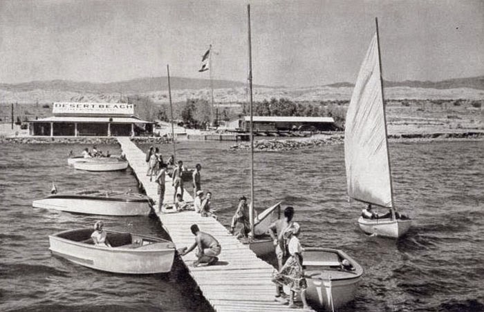
This is a late-1940s photograph from Desert Beach, from the Salton Sea Museum. The caption reads:

Skippers sail trim yachts, not subs, 40 fathoms below the Pacific on California's Salton Sea.

Desert Beach Yacht Club, 241 feet below sea level, welcomed the flyers with burning sands, 95 degree water and warm hospitality. A member of the American Power Squadron, the club holds speedboat races each fall. buoyancy of the salt-packed water makes for record-breaking runs.

Please click the link for a black and white version of Bombay Beach.

The aerial photograph was taken my my friend, Bill Birkemeier, from InTheLens.com. My daughter brought me to this great site (she knows my photographic interests). The ground-level photographs were taken with a Fuji X-E1 digital camera, with RAW files processed with Adobe Camera Raw and DxO Filmpack 3. The zombie-like atmosphere inspired me to experiment with color. The green-tone color frames were created by the cross-process emulation (i.e., E6 film processed in C41 chemicals). The red Volkswagen was faded blue, but with the Kodachrome intensity slider moved to 100%, the colors reversed. Rather cool.