Showing posts with label Beach erosion. Show all posts

Saturday, September 2, 2023

From the Archives: Summer on the Beach in Calabria (Italy)

Cosenza study area

In mid-2000, two of my coworkers and I conducted a study of beach processes and structures along the west coast of the Province of Cosenza. The Provincial Government of Cosenza asked us to examine coastal structures and beach erosion. The beaches had suffered serious retreat over the years, and various types of seawalls, beach armoring, and detached breakwaters had not stabilized the coast. 

This is the rugged and mountainous part of Calabria in southern mainland Italy facing the Tyrrhenian Sea. The first major landforms to the west are Corsica and Sardinia. The Aeolian Islands, including the active volcano of Stromboli, are also west near the north coast of Sicily. I had never been to Calabria, so this was a geological, cultural, and culinary treat. 

Our hosts were fantastically generous. They provided some superb meals (Calabria has a distinctive cuisine), a helicopter, boats, and a van with a driver. He was a burly, friendly fellow. When he wore his sport jacket on certain days, he had a mysterious bulge under his left armpit. Hmmm...  But seriously, there were no security issues of any sort. Everyone we met was friendly and curious. 

Here are a few Kodachrome slides from our project, organized from north to south. There were many more slides, but I sent them to the American Shore & Beach Preservation Association along with thousands of other beach and marine photographs


Beaches and coasts


Marina di Belvedere view south

This aerial view of Belvedere Marittimo shows the complicated topography and modified coast in this part of Cosenza. In the foreground, the beach was massively armored with detached breakwaters but this did not result in an attractive recreation beach. One major failing: the engineers did not artificially add sand on the landward side of the breakwaters after initial construction. All of these types of structures need sand to be mechanically added.


Eroded sandstone and poorly consolidated riverine sediments south of Diamante

Near Diamante, the geology is a challenge. The rail line is perched between an eroding upland and a retreating coast. To prevent mud- and rockslides from disrupting the railroad, the engineers built concrete protective walls. But then sediment no longer enters the marine littoral system, contributing to sediment starvation on the beaches. But storm waves cause the shore to retreat. So, to protect the railroad, construction companies added huge rocks along the shore. The result: no beach and a vulnerable railroad.


Recreation beach at Guardia Piedmontese Marina

Here, you can see a sand and gravel beach, with the railroad embankment immediately behind. During especially rough winter storms, salt spray reaches the rail line and causes arcing across the electric lines. This is the main north-south rail line along western Italy, and service disruption has major economic consequences. 

 
On the way it to the beach, Guardia Piedmontese Marina

  Here, the rail line is reasonably safe because it is well above the level of the parking lot.


Historic houses, Marina di Fuscaldo

Marina di Fuscaldo is a resort village with a number of pre-1900 houses clustered next to the beach. Fishermen pull their boats up across the gravel beach. The road runs above a concrete seawall.  


Former railroad bridge near Marina di Paola

This railroad bridge is an example of the beautiful stonework by master craftsmen during the original construction of the railroad in the late-1800s. The original rail was run along the landward edge of a formerly broad coastal plain. In this area, the coast retreated almost a kilometer in a century. The new railroad bridge is a short distance behind the historic bridge. There is no more room for the railroad to relocate further landward. 


San Lucida, south of Paola

These monumental T-shaped groins near San Lucida are in too deep water, the gap is too wide, and the builders did not add sand. This section of coast is sediment-starved. 

San Lucida
Checking the catch at San Lucida
Reviewing beach measurements in San Lucida

The old town of San Lucida is up on the bluff. The plaza was secured with a monumental concrete buttress and wall. 


Typical Calabrian lunch

What do you do after a morning of surveying the beaches, riding boats, or flying in a helicopter? Well, of course, you eat a giant Calabrian lunch. Add a bottle or two of wine.....


Little Cars


Ready for a ride, San Lucido
On the beach, Guardia Piedmontese


We were surprised that the tiny Fiat 500 cars (the Cinquecento) are popular again and are being restored. Fiat produced them in various models from 1957-1976. These were a brilliant way to help Italians motorize in the post-war era, and they remained in production into the 1970s. Nice! 


Motoring in Cetraro

Addendum


If you are interested in more technical details, here is the Coastal Sediments '03 conference proceeding. It is a .pdf file that the link will open. 


Sunday, July 3, 2022

When We Were Young: Beach Surveys in Rhode Island

Introduction


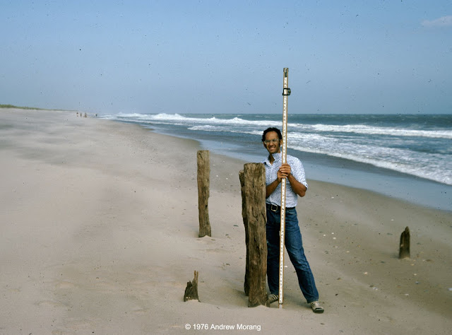
Once upon a time, during a previous life, I conducted beach profile surveys for the State of Rhode Island and Providence Plantations (the long official name, as printed on my pay checks). A technician or other graduate student and I would drive to the beaches every two weeks and survey the shape of the foreshore as far as the water line. We would survey from eight monuments (posts) that had been driven into the sand on the backshore in the dunes. In summer, we waded a distance offshore. It was a lot of fun. Summers were sunny and easy, and we mysteriously needed a full day to complete the surveys. We became dark bronze from the sun. In winter, we bundled up and sometimes slipped on the sand if it was frozen. 

Rhode Island's south shore is less developed than the coasts of many other states. This is an offshoot of the damage wrought by the Great New England Hurricane of 1938. Waves and surge from the hurricane destroyed entire communities on the south shore. Afterwards, the state wisely zoned large stretches of the barrier islands and salt ponds to be preserved as nature reserves or wildlife sanctuaries. As a result, Rhode Island's beaches today are surprisingly clean and traditional. Developers were not able to rape the environment by building multi-floor condominiums or vast McMansion tracts (in contrast, see the horrors of coastal Florida, New Jersey, Alabama, and other states). 


At the beach


Peat chunks on Charlestown Beach, August, 1976 (Kodachrome 25 slide)

After a storm, pieces of peat sometimes get washed onto the beach. The peat formed in the quiescent salt ponds, which were protected from ocean waves by barrier islands. As the barrier islands and spits retreat, the peat gets exposed on the open ocean side and is vulnerable to being broken up into chunks. This is proof of the barrier island rollover mechanism by which rising sea level causes the barriers to retreat landward. 

Yes, we had rising sea level back in 1976. We still have it, despite denials by scumbag politicians (you guess the party). We also were beginning to study the effects of greenhouse gasses on heat trapping in the atmosphere and reflectivity of solar radiation.


House remnants from before 1938 hurricane, Charlestown Beach, August 1976
Mr. Michael Schneck at old pilings, Charlestown Beach, August 1976 

When I was a student in Rhode Island in the late 1970s, I talked to people who lived through the 1938 hurricane. The memories seared them. They told me that old-timers always knew that any house at the coast should be little more than a vacation cottage with the cast-off furniture from the city house. If the storm knocked it off its posts, move it back on some new posts and re-furnish it with new castoff fittings. They scoffed at rich city slickers who built grand permanent houses next to the beach. That was the 1970s! Just visit the Outer Banks, coastal Florida, parts of Alabama, and numerous other beaches to see the monstrosities erected by developers since then.

Dr. Dan Urish enjoying the view and lunch, East Beach, August 1976

What wonderful summer days. At campus, I swam every day at lunch out to the buoys in Narragansett Bay. 

Barge formerly buried for 85 years, Charlestown Beach, December 1976
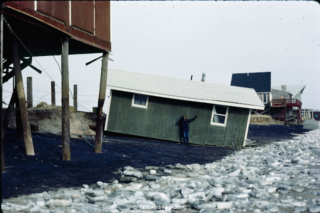
Oops. No sun bathing this day, Charlestown Beach, January 1977
Semi-exposed barge, Charlestown Breachway, Charlestown Beach, January 1977

Winter at the shore is usually quiet. Bathhouses are forlorn, as if they are waiting for their cheerful summer visitors. I wrote about Rhode Island bathhouses in 2010. 

Mr. Steve Yokubaitis, Weekapaug Beach, January 1977

On this fresh scarp, you can see roots and rhizomes throughout the sand. This shows that this dune had been mature and stable for many years before storm waves removed the seaward section. The shore face (to the very right) is covered with cobble, which is common on this formerly glaciated terrain.  

Charlestown Beach, January 30, 1977

Homeowners often hired contractors with bulldozers to push sand up to the houses. I think this was technically illegal, but do not recall if there was any legal action. 

Different states use different criteria to define private property versus public land. Public sand does not belong to private landowners, even if they think it is theirs to use. In effect, what is the definition of shoreline? Geographers and politicians have argued about this for over two centuries. If you are interested in the topic, NOAA has posted a list of shoreline references. Shalowitz' Shore and Sea Boundaries is a defining reference and summarizes technical and legal aspects of determining maritime boundaries in the United States. We will see more controversy related to shoreline definition as beaches retreat on most US coasts in the face of rising sea level (as a result of the climate change that millions of delusional Americans deny is underway).

In the next article, I will write about the Great New England Hurricane of 1938

Oops, sometimes we had to shovel the car out of the snow to get to the beach
Beginning of the great Northeastern Blizzard of '78 (flash photograph)

The Northeastern United States Blizzard of 1978 dropped record amounts of snow throughout New England. The Boston area was closed to outsiders for almost two weeks. We did not fare too badly in southern Rhode Island. We lost electricity, but we had down sleeping bags and did not have any issues. We cooked on a Bleuet GAZ camping stove. Those were the days.

The photographs above were all Kodachrome 25 or 64 slides, most from my Nikkormat FTn camera or my Leica IIIC, which I still use. I scanned them with a Plustek 7600i scanner operated with Silverfast Ai software.


Saturday, June 23, 2012

Condemned Beach Houses at South Nags Head, North Carolina

Long-term readers may remember my 2010 article on the group of condemned beach houses at South Nags Head, North Carolina. In 2010, the surf zone was literally under the piles that supported the houses, and everyone assumed they would soon collapse. The City had condemned them because of exposed septic tanks.
To everyone's surprise, the houses are still standing. And now they are perched on a beautiful wide beach, courtesy of the recently-completed beach fill. I do not understand all the details, but the owners are suing the city to be allowed to re-access their properties so that they can fix them up and un-condemn them. Only in America....

The beach nourishment project was conducted between May 24 and October 27 of 2011. Hurricane Irene on August 27 interrupted the work. For safety, the dredging company moved their equipment to Norfolk, Virginia. Storm waves caused extensive adjustment of the nourished beach profile, but no loss of sand within the project area (Kana et al., 2012).  Adjustment means sand moved deeper on the profile and morphologic features like sand bars formed, but the overall volume of sand remained within the project boundaries. Because of delays in securing federal funds for a comprehensive Dare County beach nourishment project, the Town of Nags Head elected to fund an "interim" beach nourishment locally. Total sand placement amounted to 4,600,000 cubic yards. This may be the largest locally-funded beach nourishment project completed in the United States.
Some notes on beach projects:

When confronted with severe beach erosion, local, county, and Federal authorities can choose four broad classes of technical and management alternatives (Coastal Engineering Manual, 2008, Part V.3):
  1. No action
  2. Controlled and strategic retreat
  3. Hold the line and refuse to retreat
  4. Replicate or augment the natural sediment supply to the region with artificial beach nourishment.
1. The first option is often followed on undeveloped coasts, such as in National Seashores. But even the National Park Service is now selecting to add sand to some of their eroding parks.

2. The second option, strategic retreat, is politically difficult because property owners lobby their politicians to "do something" to protect their valuable beach-front property. And, towns and municipalities derive major tax revenue from beach property, whose owners are often wealthy and often only occupy the premises temporarily.

Nevertheless, in the face of rising sea level, many communities are confronting the previously unthinkable fact that some areas will be impossible to protect and maintain. Also, taxpayers from inland areas complain that wealthy beach residents voluntarily purchased their properties in hazardous geographic locations. Why should general taxpayer revenues pay for storm recovery to let wealthy people live at the beach and profit from the appreciation of their houses (i.e., capitalism for the profit, but socialize the risk)?

3. The third option, "hold the line," was popular in the early-mid 20th century. It consists of building massive sea walls or shore-front stone revetments to mark the permanent position of the shoreline. One side is ocean, the other is city. The 1900-vintage Galveston Seawall is an example of this type of project. Seawalls have many disadvantages. They:
  • Are difficult to design and expensive to construct.
  • Have aesthetic issues
  • Require maintenance and are vulnerable to major storms.
  • Are environmentally troublesome (there is little habitat in front of a concrete wall).
  • Offer only limited recreational opportunities.
Because of cost, environmental, and permitting issues, we will probably not see new major seawall construction in the United States.

4. The fourth option is more and more popular around the world. A beach nourishment project has as its intent to replace sand onto a shoreface from where sand was lost over the years due to natural and man-made reasons. Most beaches around the United States are far from "natural" any more, and most are sediment-deficient because of various man-made reasons. These include:
  • Dam-construction on rivers
  • Sediment trapping by jetties at inlets
  • Sand lost offshore due to harbor and channel dredging, followed by deep-water disposal.
  • Sand-mining from beaches
  • Loss of sand sources due to paving and urbanization
  • Armoring of bluffs and banks
The concept of a beach fill is to pump sand onto the beach from an offshore deposit or bring in sand using trucks. The South Nags Head project is an example of hydraulic pumping from an offshore deposit.

Many critics state that a beach fill is fundamentally a failure because eventually the sand will wash away. Of course it will - that is the function of a beach! The beach serves as a flexible and sacrificial buffer to dissipate storm wave energy and protect upland development. Regular maintenance is one of the costs of living at the beach. The cost of periodic renourishment is low compared to the economic activity generated by wide recreation beaches. Think of the alternative: who comes to the coast to look at a seawall?
This is a view of the barrier island at Duck, about 25 miles north of South Nags Head. Unlike Nags Head, Duck has been relatively stable and has not suffered net beach erosion over the last half century. In this view, the Atlantic ocean is to the left and Currituck Sound to the right. The undeveloped land in the foreground belongs to the U.S. Army Corps of Engineers and is used for their Field Research Facility. It was originally a bombing range in World War II and reverted to the Corps of Engineers in the late 1960s. It is obvious where commercial property begins beyond the Army property. Much of the island has been so thickly developed, it is essentially urban.

On the Federal land, the first row of sand dunes is thickly vegetated. The frontal dune all along the Outer Banks was built by the Civilian Conservation Corps during the 1930s - another example that the beaches are not "natural." This is a photograph from the 43-m (120 ft) observation tower, which is used for experiments and continuous video imaging.
This is a view of the research pier.  Long-period swells are approaching almost perpendicular to the shore. This is the best view in Duck other than from an airplane!
The view north from the tower shows some palatial vacation "bungalows."
This photograph shows workers planting grass on a beach restoration project. The date and location were not recorded, but the scene is likely the Outer Banks. The National Park Service and other Federal agencies sponsored many dune and beach restoration during the late 1930s. These also served as work relief efforts during the Great Depression. Photograph from the Beach Erosion Board Archives, U.S. Army Corps of Engineers (from the Coastal Engineering Manual, Part I, Chapter 3).  For more information on dune construction, see Schroeder, Dolan, and Haden (1976).

References:

Coastal Engineering Manual. 2008. Shore Protection Projects, Part V, Chapter 3. Engineer Manual EM-1110-2-1100, US Army Corps of Engineers, Washington, DC (avail. online, http://publications.usace.army.mil/publications/eng-manuals/EM_1110-2-1100_vol/PartV/Part_V-Chap_3.pdf, accessed 22 June 2012).

Kana, T.W., Kaczkowski, H.L., Traynum, S.B., and McKee, P.A. 2012. Impact of Hurricane Irene during the Nags Head Beach Nourishment Project. Shore & Beach, Vol. 80, No. 2, pp. 6-18.

Schroeder, P.M., Dolan, R., and Hayden, B.P.  1976.  Barrier-dune construction on the Outer Banks of North Carolina.  Environmental Management, Vol. 1, No. 2, pp. 105-114.

Saturday, September 4, 2010

On the Beach, South Nags Head, North Carolina - 2010

East Seagull Drive, South Nags Head, North Carolina
South Nags Head is a summer playground of sun, surf, beer, and jolly good times. It's also an area of uncontrolled overbuilding on the rapidly eroding barrier island. These cottages on East Seagull Drive have been condemned because they are in imminent danger of collapsing into the surf. The view above is looking to the north, with the Atlantic Ocean to the right.The dune line is well landwards of the cottages.
The cottages were originally built on piles because in this environment, occasional flooding is inevitable. But as you can see in the photograph above, the beach has eroded so severely, the original piles were undermined. To keep the houses from collapsing, extension piles were added below the original ones. The bags are geotubes filled with sand to protect the houses. North Carolina law only allows such bags when a house is threatened. Also, North Carolina no longer allows any hard structures like rock seawalls to be erected as shore protection devices (Update: this may no longer be true as of 2020). I wish other states would follow this example.
Exposed septic tanks, South Nags Head, North Carolina

When the septic tanks are exposed (the concrete tubs above), the town or county condemns property. But then a major problem arises: what to do with the structures? FEMA formerly funded removal of houses, but I was told that the program ended. The town is taking legal action against the homeowners to remove them, but the town will not pay any of the costs. If the owners walk away and the structures collapse, the town would have to foot the bill for hazardous debris removal, not a trivial issue in the marine environment. Consider also that taking over the properties would not yield a salable commodity for the town. The town might do a beach nourishment to add enough sand to un-condemn the houses. Then they would be back on the tax rolls and generate revenue. It is an odd twist of logic.

Notice that even though only five years have passed since the disaster of Hurricane Katrina, we still are politically too cowardly to ask serious questions about whether people should live in hazardous locations, and whether municipalities have a responsibility to provide protection and services to residents of these hazardous areas. 

  • Should developers be restricted by means of setback lines? 
  • Why don't building codes require highly robust construction, thereby thwarting the quick buck artists who build shoddy homes and move on after selling to naive buyers? 
  • Should the buyer beware? 
  • Is uncontrolled building "capitalism," while spreading the rebuilding risk throughout the town/county is not considered "socialism"? 

These are all troubling questions.
The scene above shows swells from Hurricane Danielle on August 29, 2010. I took this photograph from the U.S Army Corps of Engineers' Field Research Facility (FRF) pier at Duck, NC. They are about 9-10 second period and approaching the coast at an unusually steep angle. The FRF has an excellent web page with live cameras, wave statistics, and other oceanographic data:

http://www.frf.usace.army.mil/