Showing posts with label Peloponnese. Show all posts

Friday, June 1, 2012

Nafplio, Greece: The Lower Town

This is the second part of our tour of historic Nafplio. The commercial town is built on a peninsula below the limestone hill on which the Venetian Palamidi fortress is situated. Unlike Athens and many other Greek towns, Nafplio was spared the worst of the post-World War II building boom, when characteristic and elegant late-1800s buildings were torn down and replaced with mass-produced concrete boxes.


The touristic center town is Plateia Syntagmatos (Constitution Square). I remember years ago when it was asphalt and rather grungy, with traffic. Then, about 15 years ago, an energetic major cleaned it up and paved it with marble. Now it is rimmed with cafés, restaurants, and boutiques. When it is wet, the surface is slick. (The photographs above are scans of Kodachrome 25 film, taken through a 20 mm Russar lens on a Leica M3 rangefinder camera).

The side streets are pretty interesting. This one leads west away from the Plateia. The shops on the right are built into a former mosque.

They squeeze some pretty small shops into odd corners.

This narrow lane is west of the Plateia. The restaurants here are cheaper and better than the ones along the waterfront.

The scene above was taken from a rather basic hotel where the family and I stayed in 1992. The view down the street was interesting, but one night was enough. (Scanned from a Kodachrome slide exposed through a 135 mm Tele-Elmar Leica lens).

The view directly down included this genuine Mini - a perfect car for narrow Greek streets.

On another street, an old Austin or Morris car. The body shop in town must have had a sale on yellow paint.

A surprising number of buildings are deserted or have absentee owners.

An abandoned shop, which once would have been a typical neighborhood store with groceries and odds and ends.

Near the store in the previous scene was this abandoned swimming pool.

I would think swimming in the sea would be more fun, but one day in 2005, we saw these things bobbing in the bay. No swim that day.

Sunday, May 27, 2012

Decay and Recovery: Nafplio, Greece (the Upper Town)


Nafplio (Modern Greek: Ναύπλιο, Nafplio) is an ancient city that has been occupied, decayed, and revitalized many times. It is located in the Peloponnese region of Greece at the head of the Argolic Gulf. As described in the Blue Guide Greece, "Its delightful situation near the head of the Argolic Gulf and its splendid examples of late-medieval military architecture make it one of the most attractive in Greece. Originally walled, the quiet city huddles along the north slopes of a small rocky peninsula, crowned by the citadel of Its-Kale (279 ft), towards which narrow streets, lined with old houses attractively balconied and shuttered, rise from the quay." Nafplio is about 4 hours drive from Athens and is a quiet alternative if you want to avoid the frantic city.


For a first-time visitor, I suggest you forego the cafes and whiskey bars along the trendy waterfront and tour the upper city, built on the slopes below the Venetian Palamidi fortress. The ancient houses cling to the hillside, overgrown with luxurious grape vines and orange trees.

This is one of the earliest maps of Nafplio, showing the city before 1540, when still in Venetian possession (map dated ca. 1571-75, Venice; from the Wikimedia Commons).

Following the Venetian era, the Peloponnese was part of the Ottoman empire. An occasional old Turkish fountain provides evidence of the centuries of Turkish rule.


The view into the city is a melange of clay roofs, gables, church towers, private terraces, ancient trees, antennas, and solar panels.

This large dome was once part of a mosque, but was converted to a church after Greek Independence in 1821. You can see where one of the minarets emerged from the corner.

Continuing the walk of the upper town, look at this amazing wall. The massive cut stones are Cycladic in origin (early-mid Bronze age, or older than 2000 years BCE). The crude smaller stones are much newer, clearly evidence of how old construction has been included in the modern. Notice how the Cycladic stones do not have any mortar and were fit with amazing precision. Imagine if here in USA we could casually include 4000-year-old walls into the edge of a lane.

In the next blog entry, we will explore the lower city.

Photographs taken with an Olympus E-330 digital camera with Olympus 14-54 mm f/2.8-3.5 lens (superb optic).

Thursday, May 10, 2012

Farmers' Market in Vrachati, Greece


This topic does not cover decay but the opposite: the agricultural wealth of spring. Spring in the Peloponnese is just gorgeous. The mountains still have snow, the streams are still running, and the fields are bursting with new growth. Vrachati is an agricultural town on the coastal plain facing the Gulf of Corinth, about 20 km west of the city of Corinth. Every Friday, a regional farmers market is held in the central street and plaza. Quite a mixture of vendors show up: farmers, artists with the standard nick knacks, gypsies with plastic furniture, and importers of cheap socks and underwear.


You see a variety of shoppers, including locals and city dwellers buying supplies before heading home to the city (this usually means Athens).


Of course, the produce looks really good. Once could easily become a vegetarian in Greece and live happily.


Winter is also scenic. The vineyards in the photographs above are near Halki, about an hour drive south (inland) from Vrachati.

Food everywhere is Greece is great. The ultimate farmers' market is the famous Central Market in Athens, featured in my 2011 article. Want some cheese? Plenty to select.

Nuts and figs? You can find the best here, including the figs from Kimi, a town on eastern Euboea (Greek: Εύβοια, Évia). The Kimi figs are reputed to be the best on earth - why would I disagree?

Even a regular commercial supermarket in Athens (this one in the suburb of Halandri) has great produce - hmmm, maybe better than one of our Krogers or Safeways?

And for readers with a sweet tooth, any sweet shop in Athens will fill you with nuts, honey, chocolate, espresso, and kilocalories. Back in USA, you will wonder how we can eat the offal that pass for cakes and pastries.

I took the Vrahati frames with an Olympus E-330 digital camera with 14-54mm lens. The background map is from ESRI® ArcMap™ software using ESRI maps and data.

Friday, February 24, 2012

The Kalávryta Narrow-Gauge Rack Railroad, Peloponnese, Greece


The Kálavrita (Καλάβρυτα) Railway was engineered by an Italian company in 1885-1895 in the fantastic gorge of the Vouraikós River. The original steam locomotives are long gone and have been replaced with modern diesel-electric cars, but nothing detracts from the magnificent scenery or from the achievement of the engineers some 120 years ago. The route starts in the coastal town of Dhiakftó and proceeds south (uphill) through the gorge to a high fertile plateau. Kalávryta is in the East Central part of the prefecture of Achaea. You can drive there through the mountainous and scenic Peloponnese, but many people opt to park their car at Dhiakftó and take the famous train for a day-long excursion.

This is the station in Kalávryta (2480 ft altitude). Although in use on weekends, it is pretty quiet and has a lost-in-time look to it. The town is historically noteworthy for two events. First, at the nearby Monastery of Ayia Lávra, Germanos, the Bishop of Patras, raised the flag of revolution against the occupying Turks on March 21, 1821. This eventually led to Greek Independence. The second event is more tragic. On December 13, 1943, German occupying troops massacred 1436 males over the age of 15 and burnt the town (from Blue Guide Greece, 1973 edition). (This photograph is a scan of a Kodachrome slide.)
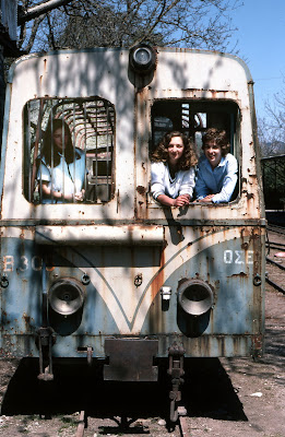
Here are the young beauties in the old rail car.


Zachloroú is the first stop north of Kalávryta, where many people get off the train and hike downhill through the gorge. In my case, I took a taxi from the coast to this station to begin the hike. The route is part of the E4 European long distance hiking path (if you are really energetic, you can walk the E4 from Tarifa, the southernmost point of mainland Spain, to Crete!). There are two tavernas right at the edge of the rail line. One of them specializes in delicious roasted rooster and local retsina, where you can fortify yourself with calories in preparation for the 4-hr trek. One of the nice things about travel in Greece is that even small rural places prepare amazingly good food. There is also a nice little hotel if you want to stay the night (perhaps you had too much retsina...).


As you proceed downhill, you pass stone work sheds and water tanks, which have been restored and painted. The Ο.Σ.Ε. must have put a lot of money into the project.

All the track was replaced in 2008-2010. From Wikipedia: "The railway is single line with 750 mm (2 ft 5½ in) gauge. It climbs from sea level to 720 m in 22.3 km with a maximum gradient of 17.5%. There are three sections with Abt system rack for a total of 3.8 km. Maximum speed is 40 km/h for adhesion sections and 12 km/h for rack sections." The total route is 33 km.


The gorge gets more and more rugged, and you wonder how the engineers managed to tunnel and bridge their way up this valley. What ambition. The tunnels are interesting because you need to be sure you are not in one when the train comes. The first time I walked the route in 2008, the system was closed while the tracks were being replaced, but the next time, I had to remember to look for the train. It's really not a problem except for the bridges and tunnels.

Finally, as you approach the coastal plain, the gradient levels out and you have an easy walk to the depot in Dhiakftó. The geology is also fascinating, and you pass through regions of conglomerate, sandstone, limestone, and alluvial outwash.


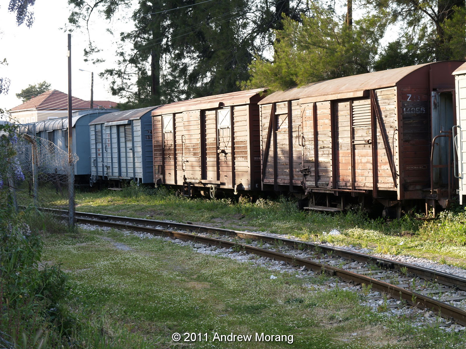
At Dhiakftó, the excursion train meets the main Athens-Peloponnese line (also narrow-gauge). A new full-gauge rail is being built to connect to Patras, but I do not know if the new line will come to this rail yard or be routed further inland.

This is the train barn. I wish I could have gone in and explored, but I was with relatives who wanted to move on to lunch.

For more information: http://www.odontotos.com/index-en.htm (accessed 11 July 2016).

The 2011 photographs were taken with an Olympus E-330 digital camera. Older frames are from film.