Showing posts with label Leica M3. Show all posts

Saturday, May 5, 2018

Small Towns in Mississippi: Bolton

Madison St. (Old US 80), Bolton, Mississippi
Bolton is an old agricultural town in Hinds County on the east-west Kansas City Southern railroad line between Jackson and Vicksburg. Many Vicksburgers who go to school in Raymond take the exit from I-20 and pass through Bolton in a hurry, likely not paying much attention. Like many other small towns, Bolton has faded. The small commercial strip is mostly empty, the shops and nearby houses rather run-down. It is sad.
The gas station at the corner of Old US 80 and Bolton-Raymond Road is now a fast food joint.
I do not know if Bolton ever had a passenger depot. This old railroad warehouse or shed is at the crossing of the Bolton-Raymond Road. I have photographed it several times over the years. The tracks and bedding are in good maintenance because this is the main Kansas City Southern east-west line.
Jackie's Beauty Boutique is just a few steps from the railroad warehouse. On January 9, 2014, the Hon. Bennie G. Thompson in the House of Representatives asked his colleagues to recognize Ms. Jackie Bailey for her contributions to the community (Congressional Record, 113th Congress, Second Session, Volume 160-Part 1) 
East of Bolton, Old US 80 runs through woods interspersed with farm fields. I am not sure how much of the route is the real 80, the former Dixie Overland Highway, and how much is 1970s-vintage frontage road.
Proceed west on Madison Street, which is also Old US 80, and you reach the police station in a tiny modern office. Across the street is a closed gas station.
Continue west, and we have cottages and shotgun houses in various states of habitation and maintenance. I like the symmetry of these older cottages. Unfortunately, there is not much more to see in Bolton.

I took most of the black and white photographs with an Olympus Trip 35 compact 35mm camera on Kodak film. I wrote about the Trip 35 in January. I also wrote about the Trip 35 on the 35MMC blog.

Update: I found a 1996 Kodachrome slide of Bolton.
Madison St., Bolton (Kodachrome 25 film, Leica M3, 90mm ƒ/2.8 Tele-Elmarit lens)


Thursday, December 14, 2017

On the Boardwalk: Coney Island 1999

Coney Island has been the summer beach playground for New Yorkers for over a century. America’s first large engineered beach fill was the boardwalk and recreational beach on Coney Island in 1922 - 1923 (Farley 1923). With the completion of the project, immigrants and factory workers could escape the sweatshops of the sweltering city and enjoy a (crowded) Sunday at the beach for only a nickel subway ride (Stanton 1999). "The Improvement helped convert nearly 2 miles of shoreline characterized by ramshackle development and narrow to non-existent beaches from which the general public was excluded, to a world famous resort that was accessible to all for no more than the cost of a subway fare." (Dornhelm 2012). Coney Island is part of the borough of Brooklyn.

In the photograph above, the odd mushroom-shaped frame was once a parachute jump, where guests would hop off and float to the ground. The boardwalk has been rebuilt many times.
Coney Island beach pumping in 1922.
Coney Island 1941. From the archives of the Beach Erosion Board, now at the Coastal and Hydraulics Laboratory, US Army Corps of Engineers.
Parachute jump,1941 or 1942 (from Library of Congress, intermediary roll film) fsa 8b00812 http://hdl.loc.gov/loc.pnp/fsa.8b00812)
This was the scene at Coney Island on a summer day in 1941 at the eve of World War II. The subway was still a nickel then.
Despite being refurbished and "urban renewed," there are still old structures and remnants of Coney Island's exuberant past.
 There is still an amusement park, but it is small compared to the ones in the 1950s.
Notice the rocket architecture, likely something from the Sputnik era when rockets were modern and trendy.
The famous hotdog stands are still there and thriving. The fries look great, but I may pass on the mystery-meat hotdogs.
This stone structure is known as a terminal groin and was built by the US Army Corps of Engineers at W 37th Street. The reason is convoluted. The community at the west tip of Coney Island is known as Seagate and is closed to the public. By law, beaches which are nourished with Federal funds must be accessible to the general public. Therefore, when the Corps of Engineers performed beach nourishments on Coney Island, the sand had to be restricted to the part of the beach east of W 37th Street (to the right in the photograph).
View across Gravesend Bay to the Verrazano Narrows Bridge from Seagate, Coney Island.
Along this shore, longshore transport is from east to west. Thanks to numerous beach fill projects, sand has filled the project to the seaward end of the 37th Street terminal groin and moves around the tip and to the shore at Seagate. The sand moves around the west end of Coney, past the Coney Island Lighthouse, and into Coney Island Creek. Some residents complained that the beach on the north side of Seagate was too wide (after decades of complaining they were suffering from beach erosion).
Rockaway Beach also has a wide boardwalk and the beach has also been nourished many times to provide storm and flood protection as well as recreation benefits.

I took these photographs with a Leica M3 rangefinder camera with 35mm Summicron-RF (the superb 8-element) and 50mm Summicron (type 4) lenses on Kodak Kodachrome 25 film. I scanned the frames on a Plustek 7600i film scanner using Silverfast Ai software.


References


Dornhelm, R.B., 2012. The Coney Island Public Beach and Boardwalk Improvement of 1923. Fourth Annual Northeast Shore and Beach Preservation Association Conference (NSBPA), October 24-26, 2001 | Stevens Institute of Technology, Hoboken, NJ.

Farley, P. P. 1923. Coney Island public beach and boardwalk improvement. The Municipal Engineers
Journal, Vol. 9, Paper 136, pp 136.1-136.32.

Stanton, J. 1999. “Coney Island - Nickel Empire (1920's-1930's).” (https://www.westland.net/coneyisland/articles/nickelempire.htm, accessed 09/27/2017)

Update, Jan. 19, 2018:  A friend sent me this interesting picture of Coney Island during Hurricane Donna in 1960. The photograph was on Facebook in the "Old Images of Brooklyn" group. Original source is unknown. It looks like it might have been a 4×5 original, so possibly from a press photographer.

Saturday, November 17, 2012

Jackson Street Branch YMCA, Vicksburg, Mississippi

Long-time residents of Vicksburg will remember that the YMCA once had two branches in town. The main facility was the handsome brick building at 821 Clay Street (see the 2010 article for interior photographs). A prominent local citizen, Mrs. Junius Ward, provided funds for this structure as a memorial to her husband.  But this was the era of segregation, so Mrs. Ward generously provided funds for a separate YMCA building on Jackson Street for African-American men. The Jackson Street Branch opened in 1924 and remained in service until the early 1990s. It was demolished in 1995 to make way for a new community center (the formal address is 923 Walnut Street).
As the photographs show, the Jackson Street branch was a handsome and formal 2-floor brick building with "1924" engraved in the panel above the entry door. It contained some residence rooms like the ones in the Clay Street branch.
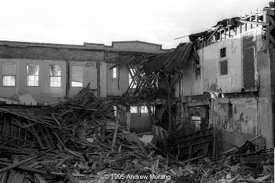
I never went inside while it was in operation, but took photographs when it was being demolished.
Interior view of auditorium, taken during demolition.  Leica M3 with 135mm Tele-Elmar lens.
Photograph taken with a Leica M3 and the 8-element 35 mm f/2 Summicron-RF lens.
The gymnasium once occupied a big section of the building. Up through the 1970s, the famous Red Tops held rehearsals every Monday evening at the Jackson Street Y, possibly in this space. As you can see, construction was substantial. I often wonder why the wood beams and bricks were not recycled rather than just crushed and trucked away.
Finally, here is another interesting structure, a remnant of the architecture that once dominated Vicksburg. This Queen Anne-style building is at 916 Walnut Street. In 1992, it was used by the Elks Club, but another fraternal organization occupies it now. As of 2013, it is on the City's condemned list. Notice the roof, covered with zinc or galvanized roof shingles.

The first photograph was taken with a Pentax Spotmatic camera with 150 mm Super-Takumar lens on Kodachrome 25 film. Black and white photographs taken with a Leica M3 rangefinder camera with 35mm f/2.0 Summicron-RF lens (the famous first generation 8-element version) and 135mm Tele-Elmar lens on Kodak Tri-X film. The square frames were taken with a Rolleiflex 3.5E camera on Kodak VPS HC film (another great emulsion that is now discontinued).