Everett is an industrial city on east-central Puget Sound, about 40 km north of Seattle and 90 km south of Bellingham. Everett was first permanently inhabited by European descendants in 1861, when a Dennis Brigham built a cabin on the shore of Port Gardner Bay. Other settlers followed, and the city was platted in 1890 when the Everett Land Company was incorporated. By the end of 1892, Everett had a population of several thousand, and its four major businesses consisted of a nail works, a shipyard, a smelter, and a pulp and paper mill (O’Donnell and O’Donnell 2010). Everett was officially incorporated on May 4, 1893, the year when the Great Northern Railway reached town. The Port of Everett was established in 1918. It thrived during the 20th century, especially as a shipping point for wood and paper products. Today, it includes both deep-water commercial docks along with an extensive marina and Naval Station Everett, a homeport for a nuclear aircraft carrier task group.
 |
| 1912 photograph of Everett waterfront (from NOAA archives). |
Lumber has always played a major role in Everett’s commerce, as shown in a 1912 historical photograph. The photograph, from NOAA archives, has a label: "The Weyerhaeuser Lumber Mill, on the Waterfront at Everett". In: "Puget Sound and Western Washington Cities-Towns Scenery", by Robert A. Reid, Robert A. Reid Publisher, Seattle, 1912. P. 92.” This and the other waterfront mills were built on landfill west of the city and west of the railroad right-of-way. Gardner Bay was filled in stages early in the 20th century.
The lumber and paper industry experienced a major downturn in the 1980s and 1990s as a result of changing economics and more strict environmental rules (Riddle 2011). As a result, Everett’s waterfront is less heavily concentrated with heavy industry and now has a more diverse mixture of industry, international shipping, recreational boating, and the U.S. Navy.
 |
| 1946 aerial photograph of Naval Station Puget Sound Everett Homeport (courtesy U.S. Navy) |
 |
| Naval Station Everett, 2005 (courtesy U.S. Navy) |
The U.S. Navy previously had a presence in Everett during World Wars I and II. During World War II, Naval Station Puget Sound Everett Homeport was located in the same basin as the present Naval Station Everett. The 1946 photograph above shows an aircraft carrier moored at a dock approximately at the present Pier Delta, and submarines are moored in the lower left.
In the 1946 photograph, the land on the upper left is Jetty Island. It consists of sand dredged from the harbor, which is brought down from the Cascades mountains by the Snohomish River. The large bulge of sand on the outer side of the jetty is the result of World-War II dredging of the naval base. The southern part of Jetty Island is narrower today. In the 2005 photograph, the sand from the south has moved north because of wave transport, and only the remnant of the 1890s jetty is visible.
Jetty Island began as a wood jetty constructed in the late 1800s. The original purpose was to enclose Everett’s waterfront and, by channeling Snohomish River water into the restricted basin, create a fresh-water port. Originally, the basin would have requires locks or gates. The benefit of the fresh-water basin was to rid wood-hulled sailing vessels of the naval shipworm (
Teredo navalis). The fresh-water port never came to fruition, but the jetty sheltered Gardner Bay from wave action, and over time, sand dredged from the Bay was placed on the outward (west) side of the jetty, creating an island. At present, much of the sand dredged from the Port of Everett by the U.S. Army Corps of Engineers is placed on the island. The island is a valuable recreation resource in summer (a swimming beach) and a small sheltered bay is a habitat for juvenile salmon, waterfowl, and bald eagles.
 |
| Priest Point |
Drive across the mouth of the Snohomish River on the I-5 or Rte 529 causeways, and you reach the Tulalip (pronounced Tuh’-lay-lup) Reservation. Proceed west and then south, and you get to Priest Point. Originally, this was a sand spit formed by sand transported from the glacial till bluffs in an eastward direction. The spit curved to the north and re-attached to the mainland. The small cottages on the spit have a classic beach look and could be in New England or Maryland. The Everett newspaper reported on a controversy regarding property leases. Many of the cottages are on land with 100-year leases. The Tribe has been unwilling to renew some of the leases, so people whose families owned some of the cottages for decades were forced to vacate. This also applies to other areas on the reservation, where expensive vacation homes (vacation McMansions?) were built on the bluffs overlooking Puget Sound.
 |
Digital elevation model (DEM) of central Puget Sound physiography, with steep bluffs and deep-water channels (developed at University
of Washington, courtesy of Washington Department of Ecology). Note the broad
delta of the Snohomish River east of Everett.
|
 |
| Ebey Island, Snohomish River delta |
 |
| Ebey Island, Snohomish River delta |
Drive up the Snohomish to the flat alluvial valley east of Everett, and you reach farms and pastures. Most of this area was drained with the help of dikes over 100 years ago. Part of the area is the Snoqualmie Wildlife Area Ebey Island Unit. The forested portion was logged in the 1890’s and has become reforested naturally into one of the few remaining sitka spruce swamps.
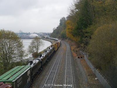 |
| BNSF railroad, photograph taken at Howarth Park. The Port of Everett is in the distance. |
South of Everett, the coast consists of glacial till bluffs, extending as far as Seattle. The waters' edge has only limited access because the Burlington Northern Santa Fe (BNSF) railroad revetment hugs the shore.
In 1891, the Great Northern Railroad completed its line along the shore of Puget Sound between Seattle and Vancouver, British Columbia. South of Everett, the rail bed was built on the upper beach at the base of the bluffs. Along much of the 53-km stretch between Seattle and Everett, a rock revetment was built to protect the tracks from storm waves. Much of the excellent stonework was performed by Chinese laborers, working under harsh and dangerous conditions (Huang 2006).
 |
| Howarth Park path to the railroad pedestrian overpass (November 2013). |
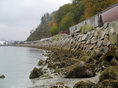 |
| BNSF railroad revetment (seawall) at Howarth Park |
One of the few public beach access points is at Howarth Park, where a steel pedestrian bridge crosses the tracks. As you can see from the algae line, at high tide, the water is about 1 m up the revetment and the beach is totally underwater. Before the armoring provided by the railroad
revetment, the bluffs
would have supplied sediment to the beaches. Wave action would have moved beach sediment to the northeast. But this geomorphic process is now essentially stopped.
 |
| Former mass-wasting scarp, Howarth Park. |
Retreat of coastal bluffs is a complex process driven by wave-induced toe erosion and hilltop mass-wasting. Wave erosion is episodic, driven by combinations of unusually severe storms and high tides or (or possibly during temporarily elevated sea levels during El Niño cycles) (Shipman 2004). Mass-wasting is typically triggered by heavy rainfall, elevated groundwater levels, and freeze-thaw cycles (which are usually a minor factor in Puget Sound).
In some areas, animals (goats), trees, and man-made manipulation contribute to slope failures. In Puget Sound, bluff erosion typically occurs in pulses, where a bluff is stable for years or decades and then experiences a major landslide as a result of a major rain event or storm during high tide. Retreat rates vary greatly spatially, but typical rates for Puget Sound beaches are around 2.5 cm/year. The relatively low retreat rate may partly account for the narrow beaches in the Puget region. Bluff retreat rates vary greatly around the country. As an example of a high rate, glacial till bluff retreat on Lake Erie in western Pennsylvania during the 20th century averaged 1 m/year (Morang, Mohr, and Forgette 2011).
In the photograph above, taken at Howarth Park, a former slide scarp is in the process of re-vegetating. The trees have grown straight, indicating that the slope has been stable for some years.
Although construction
of revetments and bulkheads may effectively protect upland areas and infrastructure from wave
attack, it does not fully prevent mass-wasting due to rain events. The railroad regularly needed to clear off
debris from landslides over the last century. We assume most of the material was disposed on the beach, therefore at least partly restoring sediment supply. In addition, a revetment did not prevent
continued retreat of the beach itself, with the result of a gradual narrowing
of the remnant upper beach and loss of upper intertidal habitats (Shipman 2008; 2010). Another effect of structures is to alter
natural patterns of drainage to the beach because streams and runoff are
concentrated in culverts and under bridges. The ecological effects of armoring may be especially profound because of
the loss of nutrients to the coastal zone and loss of habitat associated with
beaches
 |
| Mukilteo Point, view west, circa. 1910. The Superior Shingle Co. mill was in the foreground and the Crown Lumber Mill in the background. (Photograph no. 200.201.036, courtesy of the Mukilteo Historical Society). |
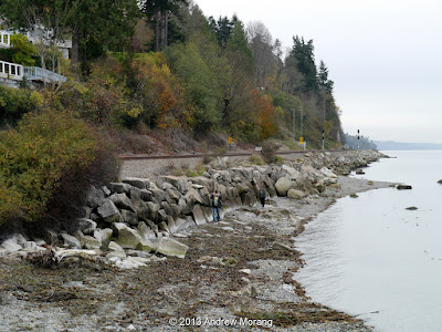 |
| BNSF Railroad revetment from Mukilteo Point (south of the ferry landing). |
Another beach access is at Mukilteo Point, where the ferry boat crosses to Whidbey Island. The 1910 photograph demonstrates how active the lumber industry was in this area. Looking south, the railroad revetment continues south with a remnant of gravel beach in the foreground.
Snohomish County has proposed placing sand dredged from
Everett harbor on the beaches along the BNSF revetment. Numerous
logistic and regulatory problems would have to be overcome. Also, medium-coarse sand is not the
native beach material on these beaches, which normally include a high
percentage of gravel derived from the till bluffs. We do not know how a sand beach would respond
over time. Unlike open ocean coasts,
Puget Sound does not have swell waves to rebuild beaches when storm waves move
sand offshore. Also, most beaches have a
low-tide terrace, which abruptly drops off into deep water. Sand moved beyond the edge of the terrace
would be lost from the littoral system. Prototype tests will be needed to assess
whether beach nourishment using harbor sand is viable in this area. Potential beach placements will also have to be adapted to future sea level rise scenarios.
As you can see, man-made modification of the natural environment can have profound effects, often lingering for centuries.
For a much more comprehensive view of Puget Sound beaches and estuaries, see Hugh Shipman's blog,
Gravel Beach. Department of Ecology has a web page on their
Puget Sound Initiative. I thank my friends Hugh Shipman and Ashley Frey for their companionship and their help interpreting coastal morphology.
References
Huang, A (ed.). 2006.
Silent Spikes, Chinese Laborers and the Construction of North American Railroads. Translated by Zhang Juguo. China Intercontinental Press, Beijing, China, 177 p.
Morang, A., Mohr, M.C., and Forgette, C.M. 2011.
Longshore sediment movement and supply along the United States shoreline
of Lake Erie. Journal of Coastal Research, Vol. 27, No. 4, pp. 619-635.
O’Donnell, L., and O’Donnell. J. 2010.
The
Evolution of a Vibrant Everett Waterfront, A Story of Sawdust, Salmon & Speedboats. Port of Everett,
Everett, WA. (available online:
http://www.portofeverett.com/docs/nmr_introduction.pdf
, accessed October 28, 2013).
Riddle, M. 2011.
Port of Everett Commissioners approve the sale of land to the U.S. Navy
for an aircraft carrier base on May 5, 1987.
HistoryLink.org Essay 9889 (available online,
http://www.historylink.org/index.cfm?DisplayPage=output.cfm&file_id=9889
, accessed November 1, 2013).
Shipman, H. 2004. Coastal Bluffs and Sea Cliffs on Puget Sound, Washington, In: Hampton, M.A., and Griggs, G.B. (eds.), Formation, Evolution, and Stability of Coastal Cliffs— Status and Trends, U.S. Geological Survey Professional Paper 1693, 81-94.
Shipman, H., 2008, A geomorphic classification of Puget Sound nearshore landforms. Puget Sound Nearshore Partnership Report 2008-01. Washington Sea Grant Program, University of Washington, Seattle, WA, 37 p. (available online,
http://www.pugetsoundnearshore.org/technical_papers/geomorphic_classification.pdf, accessed November 18, 2013)
Shipman, H. 2010. The geomorphic setting of Puget Sound: Implications for shoreline erosion and the impacts of erosion control structures, In: Shipman, H., Dethier, M.N., Gelfenbaum, G., Fresh, K.L., and Dinicola, R.S. (eds.),
Puget Sound Shorelines and the Impacts of Armoring—Proceedings of a State of the Science Workshop, May 2009. U.S. Geological Survey Scientific Investigations Report 2010–5254, pp 19-34 (available online,
http://pubs.usgs.gov/sir/2010/5254/pdf/sir20105254_chap2.pdf, accessed November 18, 2013).