Showing posts with label shotgun shack. Show all posts

Saturday, January 13, 2018

More Long-term Decline: Tallulah, Louisiana

Snyder Street, Tallulah, Louisiana
Tallulah, the parish seat of Madison Parish, Louisiana, is a small town in northeast Louisiana just off Interstate 20. I remember going there about 25 years ago with some other photographers to take pictures. It was rather forlorn then, and is even rougher today. The main businesses are the parish government and the large state prison on Green Street, with agriculture in the surrounding farm fields.
220 Snyder Street, Tallulah, LA, Dec., 2016.
Depot Street, Tallulah (digital file from 2013)
Snyder Street, facing the railroad tracks, was once the thriving commercial strip. Today, most of the store fronts are empty, and a couple of roofs have collapsed. Several times a day, a Kansas City Southern freight rumbles by, often with four locomotives pulling container carriers. This is the new global commerce that has left towns like Tallulah behind.
East Green Street is also U.S. Highway 80, which runs east-west through town. A number of old commercial buildings are in various states of use and abandonment. Before the 1970s, U.S. 80 was the only major highway, and all through traffic drove right through town. But I-20 was routed south of town, and today, most travelers ignore the city unless they specifically have a need to pull off at the Tallulah exit (and many of them just go to the truck stops and then continue on the interstate).
The Madison Parish Court House was cheerful and crowded during the 2013 Teddy Bearfest. I wrote about the 2013 Teddy Bearfest in a previous article.
This is one of the many abandoned stores, this one on Chestnut Street, facing the courthouse.
East of town, Louisiana Route 602 takes a U-shaped path south of the interstate. It makes an excellent bicycle route as you pass farm fields, silos, and patches of woodland.
Former restaurant, 314 West Green St., Tallulah
Former teen center, 407 West Green St., Tallulah
Abandoned house, 522 West Green St. This structure is no longer extant.
Closed store, 800 West Green Street, Tallulah
Heading west on Green Street, which is U.S. 80, you pass some rather rough neighborhoods, then pass the prison, and eventually get to farmfields. The main attraction to the west is the Tensas River National Wildlife Refuge, which has a large resident bear population.
Shotgun houses across the street from the prison, U.S. 80.
The rectangle black and white photographs are from a medium format Fuji GW690II camera with 90mm f/3.5 lens. The film was either Kodak Panatomic-X or Kodak Tri-X 400. The 2017 view of shotgun houses is from a Hasselblad 501CM camera. I scanned the negatives on a Minolta Scan Multi film scanner using Silverfast Ai software.

Sunday, July 2, 2017

Shotgun Houses and Grayson Court, Jackson, Mississippi - 2004

Grayson Court was an old-fashioned alley running south from East Fortification Street and just west of North Lamar Street in Jackson.
I do not know much about the history of these types of "courts," but I assume they were built in the early 20th century to house industrial workers. The men from Grayson likely went to Mill Street to the railroad or various industrial concerns, while the women worked as domestics around town.
By the early 2000s, the little houses at Grayson Court were in poor condition. But some had been recently refurbished.
I met a gent with painting equipment and tools at one house. He said he had been fixing the houses and was mad that they had been condemned. Then another fellow came up and the painter chased him away with a hammer. The carpenter said he was a drug-dealer.
Some of the houses had been secured to prevent vandalism. But in the mid-2000s, all these houses were cleared away, and the site is now a flat empty lot.
A few blocks away, on Blair Street, rows of early 20th century cottages were also closed and secured. Notice that the porch supports are missing in this 2004 photograph. Here, too, I think most of these houses have been demolished. Possibly a reader can share some history of this area.

Photographs taken with a Fuji GW690II 6×9 medium format camera on Kodak Panatomic-X film, developed in Agfa Rodinal developer at 1:50 dilution. The camera was tripod-mounted for all of these frames.

Wednesday, October 19, 2016

From the archives: Vicksburg in 1997 with Agfa Scala film

About 20 years ago, the venerable German photographic company, Agfa, made a black and white transparency film named Scala. It was intended to be projected, meaning to be used for black and white slides that would be projected on a screen. I tried Scala several times and liked it, but did not use it regularly. The Scala was ISO 200 and needed to be processed at a laboratory with the correct Scala chemicals. Possibly you could buy the chemicals for home use, but I never checked. Recently, I rediscovered my 1997-vintage Scala 35mm slides and did a test scan with my Plustek 7600i scanner. They looked really nice and I scanned most of the roll. Here is a semi-random tour of Vicksburg, Mississippi.
In the 1990s, three river boats regularly visited Vicksburg, the Mississippi Queen, the Delta Queen and the American Queen. All three stopped service during the economic downturn of 2007-2009. The Mississippi Queen was cut up for scrap in 2011. The Delta Queen, which was made of wood, can no longer be used for passenger traffic. But the American Queen is now (as of 2016) back in service with regular stops at the Vicksburg waterfront on the Yazoo diversionary canal.
In 1997, the Harrah's Vicksburg Casino was moored in its cofferdam on the canal side of the floodwall. The hotel was on land, but the gambling facilities had to be on floating plant. The subsequent owners of the casino filed for bankruptcy, and the barge is now moored in the Yazoo River near the Ergon petroleum refinery (I assume awaiting scrapping).
Vicksburg's famous Attic Gallery was formerly at 1404 Washington Street above Michael's Jewelry. The Gallery was a great place and packed tight with sculpture, paintings, and stuff. Attic Gallery now is at 1101 Washington Street and almost as tightly packed with interesting things.
This was the steel framing for the Vicksburg Convention Center on Mulberry Street.
This photograph shows some of the earthwork done for the convention center. The Bunge Corporation grain elevator on Levee Street is in the distance, with the Yazoo Canal beyond.
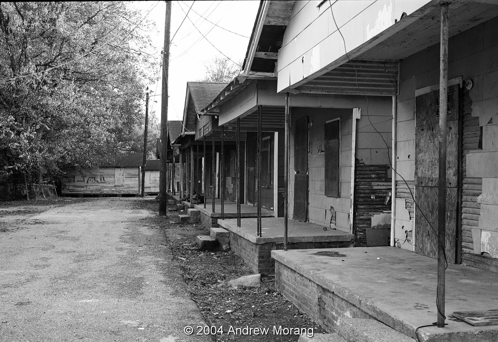
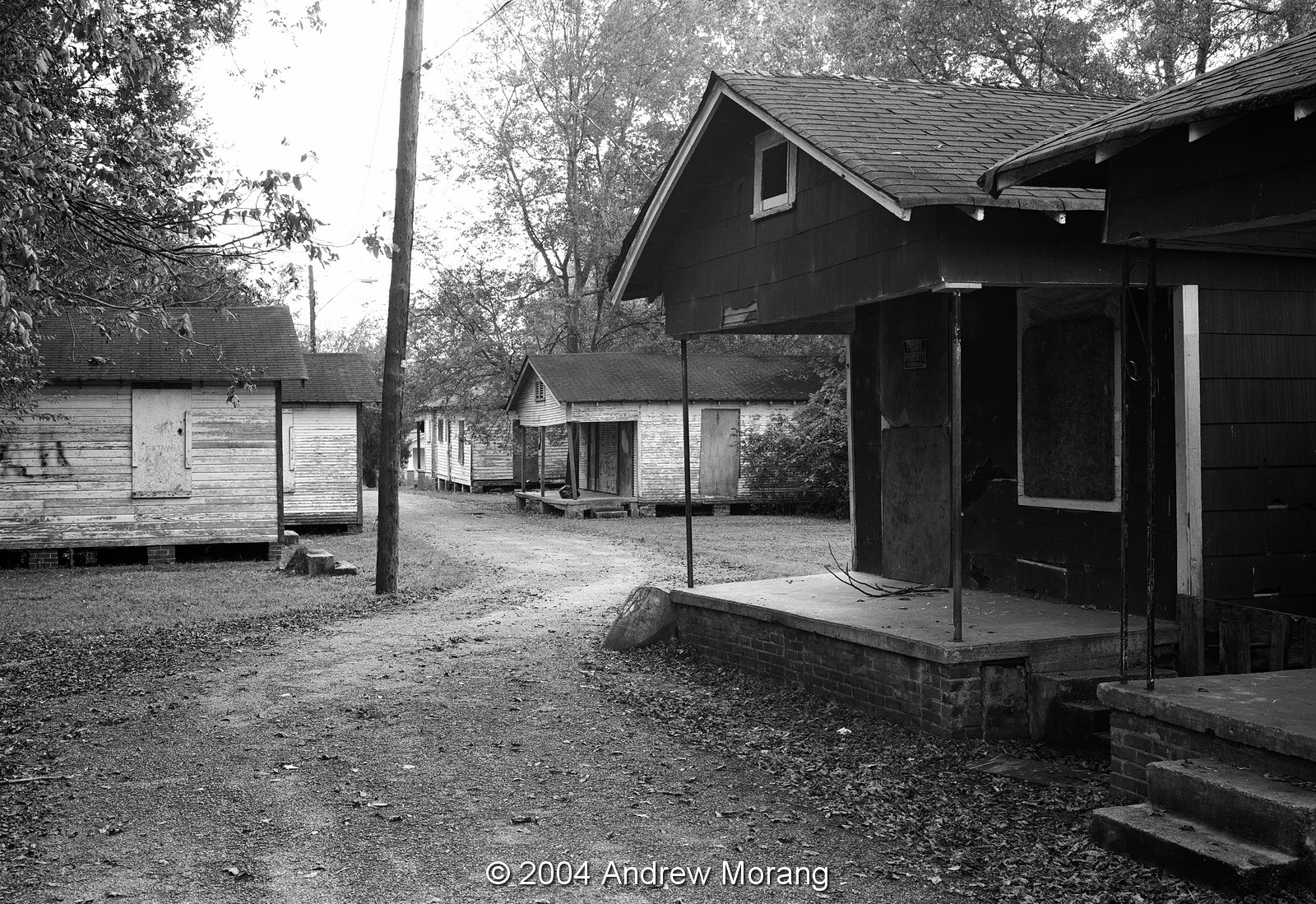
Oak Street is one of Vicksburg's older residential neighborhoods. No. 3517 is an early 20th century duplex.
Pearl Street parallels the railroad tracks. This cottage at 2521 was also a duplex and still had the characteristic split porch pillars that can be seen in many older Vicksburg houses. As of October 2016, this building is still occupied. Many other shotgun shacks and cottages that once lined Pearl Street are gone.
These almost-twin shotgun shacks are at 1300 and 1302 Harrison Street. As of 2016, they are still extant.
An old Plymouth has been parked in the garage of 920 National Street for decades. I have never seen any occupants, but someone maintains the grounds and house, so it is not abandoned.
This is the railroad cut between Belmont and West Pine Streets. I took this photograph on Feb. 3, 1997, just after an ice storm draped the kudzu and branches with ice.
This is North Fisher Street, also draped with ice.
By the time I took this picture of Letitia Street, the ice had already melted from the street.
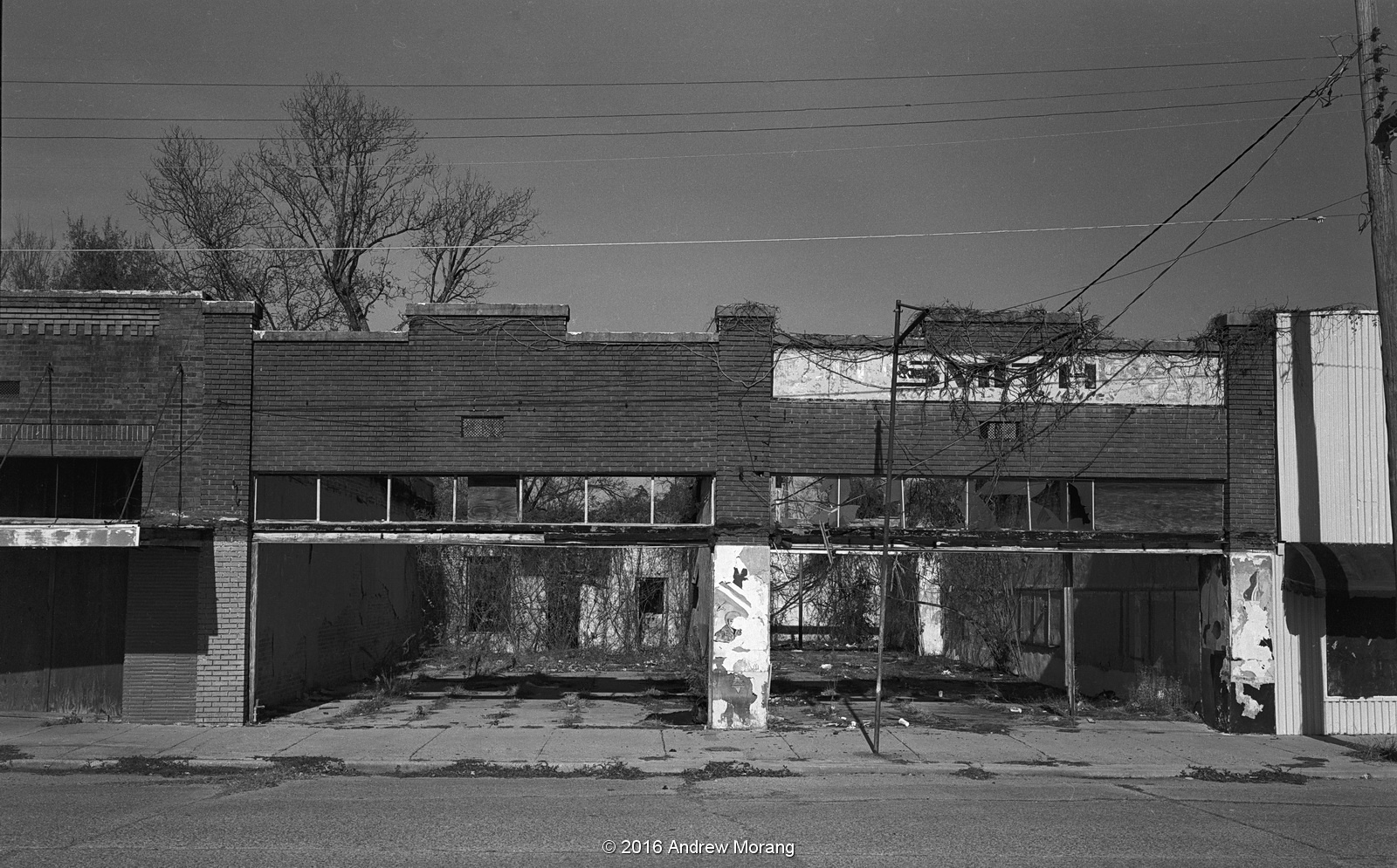
This little church on Yazoo Street was condemned and scheduled for demolition as of mid-2016.
The cottage at 1101 Stouts Street, near the Yazoo Street church, is also gone.
Finally, we have another duplex cottage at 2729 Alma Street. The house no longer exists, and the lot has reverted to jungle.

Sadly, Agfa is gone, another victim of the digital imaging era. The company was founded in 1867 as Aktiengesellschaft für Anilinfabrikation and renamed Gevaert & Co. in 1894. Once a prominent European manufacturer of film, papers, and chemicals, Agfa-Gevaert sold their consumer imaging division in 2004 to a management buyout. But within a year, the new AgfaPhoto GmbH had filed for bankruptcy, ending over a century of top-quality film and paper manufacture. I still use their Rodinal film developer, which was invented in 1891 by Dr. Momme Andresen. Fortunately, Rodinal is still made, now by Adox, another old-line photo company. How many other 120-year-old consumer products can you buy? Freestyle Photographic Supplies in Los Angeles sells Rodinal as well as Adox and other traditional black and white films, but Scala is gone forever. Shoot more film!

All of these photographs were taken with a Leica M3 rangefinder camera, most with 35mm or 50mm Summicron lenses. I wrote about Leicas in a 2014 post.
Example of a 5-pack of 120-size Scala film. 

Friday, August 26, 2016

Travels on the Mother Road, Route 66 - Part 7, eastern Arizona

We continue our trip on Route 66 through Arizona. Heading east, once you reach Seligman, Arizona, Route 66 follows I-40, with some sections of old pavement and some sections along the frontage road.
Ash Fork is a tired old railroad and quarrying town, once said to be the Flagstone Capital of the World. The town was founded in the 1880s, and the name Ash Fork may be from the ash tree where outlaws were hanged. It is at elevation 5144 ft, but my car did not yet noticeably bog down in the thin air. Route 66 splits, with the eastbound following one main road through town and the westbound on another road. Flagstones decorated the front of the Oasis Lounge on Park St., which is the eastbound path.
I was surprised to see a shotgun shack. I thought this was an style mainly used in the US southeast and did not know they were built in the west, too.
Huge flagstone form sidewalk steps, evidence of the former quarrying output.
The Emmanuel Trinity Methodist Church at 47243 N Fourth Street has a stone veneer replacing the former windows of this shop. Note the unusual bas-relief statues.
The church bus had seen better days, like most of the town.
Not a bad Chevrolet wagon. Old cars don't rust here in the dry high altitude air.
The political message on the old shipping container was a bit (well, very) obscure.
I pressed on eastward on I-40 because I was short on time. I had lunch in Flagstaff but saw nothing there of Route 66 interest. Flagstaff is touristy because of its access to Grand Canyon National Park, and much of the downtown has been rebuilt. I found a gasoline station with ethanol-free fuel and continued east. I pulled off at Joseph City, which was founded by Mormon settlers in 1876. Today, there is not much city here, and the Old Historic Route 66 Hay Sales & Feed was closed.
I processed these two in color to show the subtle colors. The painting on the teepee proves that aliens have been here.
Downtown Joseph City was rather depressing. So many of these small towns are just drying up.
My last stop in Arizona was in Houck. At one time, Fort Courage was a replica of the fort used in the doofy 1960s television show F Troop. As far as I could tell, Fort Courage was closed permanently, as was the adjoining Pancake House, with its huge teepee holding up the sign.

This is the end of my travels on the Mother Road in Arizona, and the next article will be in New Mexico. Photographs taken with a Fuji X-E1 digital camera, with some files processed in PhotoNinja software.