Tuesday, January 10, 2012

Cotton Compress, Levee Street, Vicksburg, Mississippi

For many years, a complex of brick and steel sheds stood on the west side of Levee Street close to where the historic Fairground Street bridge crosses the Kansas City Southern railroad yard. This was the cotton compress, address 2400 Levee Street (see the circle on the map).
This post card, circa. 1911, is from the Ann Rayburn Paper Americana Collection, Special Collections, University of Mississippi Libraries (originally from the International Post Card Co., New York, N.Y.).
This is a glass negative from the George Grantham Bain Collection at the Library of Congress, with title, "Louisiana Flood 1912, Cotton Compress at Vicksburg as a refuge." I am not sure if any of these buildings still stand.
According to a December 17, 2010, article in The Vicksburg Post, the compress facility dates to 1903 and formerly housed a cotton gin and 13 warehouses and sheds with about 340,000 square feet of storage space. The view above was taken from the top of the levee looking east at about the same location as the 1912 flood photograph. Vicksburg is on the hill in the distance.
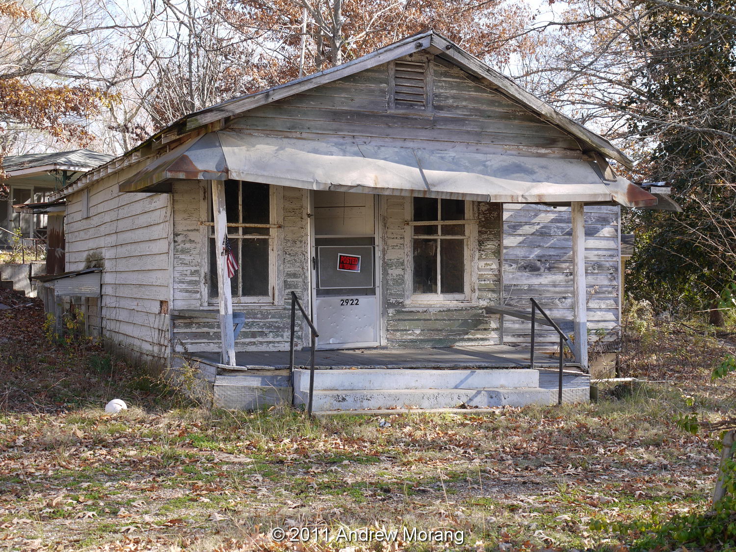
These two views show part of the complex from Levee Street. The Post did not specify how long the compress had been unused, but the buildings were in poor shape because of water damage and asbestos exposure following years of vacancy. Notice the sign on the ground with scripture.
This press was under the tower in the upper photograph. I do not know the mechanics of how it worked, but I remember seeing steam and activity in the 1980s, when this was still a going concern.
A developer told the city's Board of Architectural Review that the Vicksburg Compress company planned to use some of the buildings as a self-storage facility. Other buildings would be demolished, and the 1940s water tower would be removed because it was unsafe.
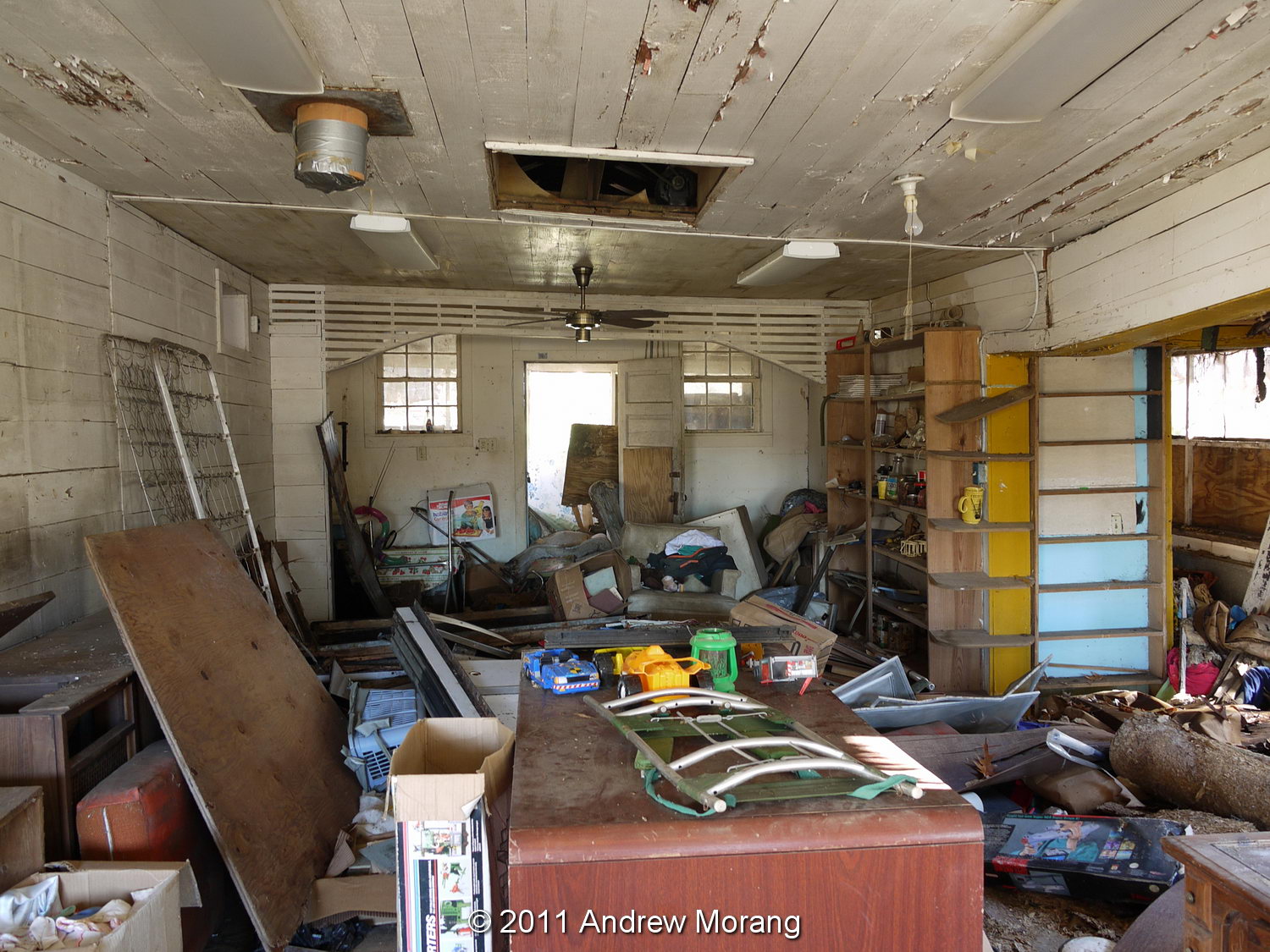
The interior had typically interesting industrial archaeology to examine (and I like exploring places like this). Notice the large wood timbers holding up the roof.
The grimy old workbenches still had tools, pipe, and cans of chemicals strewn about.
You could even wash up...maybe.
Someone had stored some old American muscle cars, but they were in no better condition than the buildings.
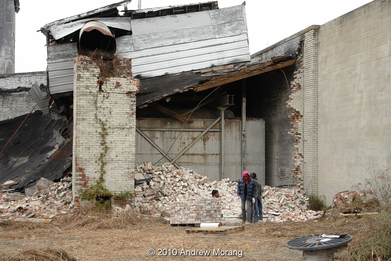
While I was exploring on a December day in 2010, a small team was cleaning up bricks and loading them on pallets.
As of December 2011, many of the brick walls are gone, and I assume the bricks have been sold. But the steel sheds are still unused, and the water tower is still standing. These projects tend to take a long time in Vicksburg.

An interesting article on cottonseed oil mills is in:  Wrenn, L. B. 1994. Cotton gins and cottonseed oil mills in the New South. Agricultural History, Vol. 68, No. 2, Eli Whitney's Cotton Gin, 1793-1993: A Symposium (Spring, 1994), pp. 232-242. (Published by: Agricultural History Society)

These are digital images from a 10 megapixel Sony R-1 digital camera, tripod-mounted. The interiors were multi-second exposures, good examples of how well-suited digital cameras are for low-light conditions. You no longer have to worry about reciprocity failure and color shifts as with film; just set the exposure and let the shutter stay open as long as needed. The R-1 has a superb Schneider lens.

Some black and white Panatomic-X film photographs of the compress are in my 2018 article (please click the link). 

Monday, January 2, 2012

Scott Field, Tallulah, Louisiana


Rural USA is dotted with small airports. Many are only used for private aircraft, but some had significance in the early years of civil air transport. Scott Field in northern Louisiana is one of these. To get there, take the Interstate-20 exit to Tallulah, turn right on US80, drive a couple of miles east and turn left (north) on a dirt road. You will see a number of steel hangars containing crop-duster aircraft and this old-fashioned Spanish-style building with a "Standard Oil Company of Louisiana" sign on the side.

In 2002, a sign provided some historical context, but the sign is now gone. Several web pages describe this as the site of an agricultural experiment station and the origins of Delta Airlines, but possibly it is a bit of a stretch. Deltamuseum.org gives a more detailed review of how the Entomology Bureau of the U.S. Department of Agriculture set up a laboratory in Tallulah in the early 1920s to conduct large-scale cotton insect research. The laboratory, which was at another site in town, conducted experiments in boll weevil eradication and dispensing calcium arsenate from the air. In 1922, the Army Air Service sent three aircraft and pilots to an airstrip near Tallulah. Later named Scott Field, this was to become the first municipal airport in Louisiana. Based on the success of these tests, C.E. Woolman operated dusting operations in Louisiana, Mexico, and Peru in the mid-1920s. He returned to Monroe, Louisiana, to set up a new new company named Delta Air Service with the support of Monroe businessmen. On June 17, 1929, Delta Air Service operated its first passenger flight over a route that stretched from Dallas, Texas, to Jackson, Mississippi. For more background, see Delta Air Lines: 75 Years of Airline Excellence by Geoff Jones.

This is Delta's terminal in Monroe, very similar in style to the Tallulah building.
Scott field terminal building (now unused)
The terminal building, dating from 1930, according to one source, is a simple but elegant structure with cheerful windows all around. Sadly, most of the window panes have been broken out, but the roof seems largely intact. I have no information about the architect. The US Marine Corps used Scott Field for training during World War II. I also have no information on what years the field provided commercial air transportation.

The interior is a mess and little or nothing is left of original fittings.


The second floor is accessed via exterior stairs, suggesting an add-on construction.

The roof is especially interesting. It looks like clay tile but is really made of zinc-coated steel units. Various companies made these metal tiles in the early 20th century. The very interesting Preservation in Mississippi web page has a 2011 article discussing use of of metal shingles.

(1991 and 2002 photographs taken with Leica rangefinder cameras with 50 mm f/2.8 Elmar lens on Kodachrome 25 film. 2012 photographs taken with a Panasonic G1 digital camera.)

Saturday, December 31, 2011

Historic Temples, Patan, Nepal

I want to follow-up on the previous post of hidden courtyards of Patan with some photographs of temples and more common tourist sights. Patan is a visual delight in every way. Most tourists are dropped off on Mangaal Bazaar in front of the ticket booth at Durbar Square and proceed north past a series of temples and the palace complex.

Note that in Nepal, temples are not just sterile monuments visited by tourists, but are used by local residents in their every day lives. Old folks sit and watch the view, younger folks play games or chat.

One of the first temples on the left is the Hari Shankar Mandir, dedicated to both Vishnu and Shiva. Note the fantastic carved doorways and lintels, and the unusual "ears" off the doors. Most of these temples needed major rebuilding after a powerful earthquake in 1934.

The young ladies are taking portraits of each other at the Jagan Narayan Mandir, built in 1565.

The next one north, with an old lady enjoying a cig, was the Bishwanath Mandir.


I did not take many photographs in the Palace, but many of the architectural details showed interesting shadows and patterns. The wall by the main entrance is a popular place for the local gents to sit and watch the local scene. The Palace was mainly constructed in the second half of the seventeenth century and substantially rebuilt after an invasion in 1769 and the 1934 earthquake


Many visitors go to the Hiranyavarna Mahavihara, popularly known as the "Golden Temple". It may be one of the most opulent small temples in Patan and occupies a cramped courtyard of the 12th century Kwa Bahal Buddhist monastery. Tourists are not allowed to take any leather inside, but modern synthetic running shoes are all right. I am not sure about the symbolism of the monkeys sitting next to the prayer wheels, or the purpose of the chains draped over one of the monkeys. Possibly a reader can enlighten me. The monastery is active, and upstairs, I saw a European gent chanting and leading a group in prayer.

Again, I want to emphasize that Patan is a living city, not some dead architectural site. People, shops, traffic, noise, and smells are everywhere. It's a bit run-down, but from constant use, not abandonment and neglect.

Another theme that impressed me about Nepal is the commerce being carried out everywhere. The jolly bald gent sells singing bowls. Amazingly (or diplomatically) he remembered me after an absence of four years. He even convinced me to buy another bowl!

The gent with the flowers threads them on long strings.

If you don't want brass bowls or flowers, why not buy a chicken?

This petite mother was taking her children to school. This was another theme that impressed me about Nepal: the strong education ethic. Families believe strongly that education will help their children achieve better lives. We in USA could learn from the Nepalis.

Photographs taken with Olympus E-330, Panasonic G1, and Fujifilm F31fd digital cameras.

Friday, December 23, 2011

Hidden Courtyards of Patan, Nepal

Patan is one of the three independent kingdoms that once flourished in the Kathmandu valley of Nepal (the others being Kathmandu and Bhaktapur). Urban sprawl now encompasses much of the valley, but Patan still feels distinct and features unique architecture and cultural institutions. The historic name is "Lalitpur," or City of Beauty. According to The Rough Guide's Nepal, legend credits Patan's founding to King Arideva in 299 AD. By the seventh century, Patan had emerged as the artistic and cultural center of Nepal and a large expanse of the Himalaya. It remained a sovereign state until 1769, when Prithvi Narayan Shah conquered the valley and chose Kathmandu as his unified capital. In many ways, the historic core is frozen in time as it was in 1769. Therefore, Patan is an architectural gem well worth a visit.


The tourist map shows Patan's location south of Kathmandu City. It is a short taxi ride there, but, depending on traffic, it may be rather time-consuming. Walking would be unpleasant with the constant cacophony of horns and stench of exhaust. Odd note: the tuk-tuks, that formerly belched terrible 2-stroke exhaust fumes, are now electric!! The electric motors and batteries were installed as a simple upgrade via a program funded by US Aid and the Asian Development Bank. The tuk-tuks retained their original transmissions, and the motors were connected to 2nd. gear. The photograph shows the normal status of a tuk-tuk: packed with customers.

Most tour groups alight from their taxis or buses in front of the historic Durbar Square, where the palace and many of the temples are located. This is a UNESCO Heritage Site. We tourists have to pay an admission fee, and there is another admission into the Palace.

In this article, I want to concentrate on streets and alleys that tourists might overlook.
Patan, like the rest of Kathmandu, is a full of tiny shops selling all sorts of goods. You can buy fabrics, pots and pans, clothing, incense, magazines, food, singing bowls, religious goods, brassware, cosmetics, and more.
Remember the Ladies of Nepal? This must be where they buy their underwear.

Once you get off the main thoroughfares, the narrow alleys are shaded and private, often only wide enough for motorbikes.
But wait, there is a hidden side to Patan: many of the houses and apartments were built around a courtyard that is accessible via narrow arched passageways. The courtyards feature a well that provided drinking water for hundreds of years, and many are still in use. I was amazed that the residents aren't using piped municipal water.
There is another world in these courtyards. Some are dingy, others joyful and full of life.
In some, individuals sit and watch the scene. In others, children play ball. The people I met were very friendly and probably wondered, "What is this odd tourist doing here? Did he lose his way to the palace or the toilet?"
Some of the houses are really old, mid-1800s I guess. Often they are intermixed with 20th century flats. The next serious earthquake will be real trouble here. Some of the old bricks had the swastika symbol baked into the surface. According to Wikipedia, the symbol was widely used in Indian religions, specifically in Hinduism, Buddhism and Jainism, as a tantric symbol to evoke 'shakti' or the sacred symbol of good luck.
The sunnier courtyards often had piles of grain with ladies carefully tending it. No mice and rats? Maybe the cat or snake population takes care of the vermin. Regardless, it's a fascinating place to explore. Highly recommended.

I took these photographs with a Panasonic G1 micro four-thirds (µ4/3) digital camera with 9-18 mm Olympus or 14-45 mm Lumix lenses, 22 October 2011.

Saturday, December 17, 2011

Hoben's Country Store, Old Hwy. 27 and Warriors Trail, Vicksburg, MS


This traditional wood-frame country store is at the junction of Old Highway 27 and Warriors Trail, southeast of Vicksburg. A decade or two ago, it was still open for business, but I am not sure when it closed. Possibly a reader can provide some information. Somewhere in my files, I may have a Kodachrome slide of this store in operation.

At one time, small locally-owned stores like this were found along rural roads throughout the south because rural farm workers did not have cars and had to walk or ride a wagon to get supplies. Needless to say, they are a dying institution, and the remaining examples are falling down, burning, or being torn down.

The roof on the main building is still intact, and it looks like the owners have been storing miscellaneous junk for awhile. Notice the wood boards forming the interior walls. Ultimate fate: unknown.

(Photographs taken with a Panasonic G1 digital camera with 14-45 mm Lumix G Vario lens, ISO 100, December 17, 2011.)