Saturday, February 18, 2012

A Ride on the Piraeus, Athens, and Peloponnese Railway

As I wrote in the previous article, the Piraeus, Athens and Peloponnese Railway was a narrow gauge (1.00-meter) line that once connected small towns in the Peleponnese area of Greece with Athens. Let's take a trip down memory lane, riding the rail from the west end of the Gulf of Corinth to Athens.

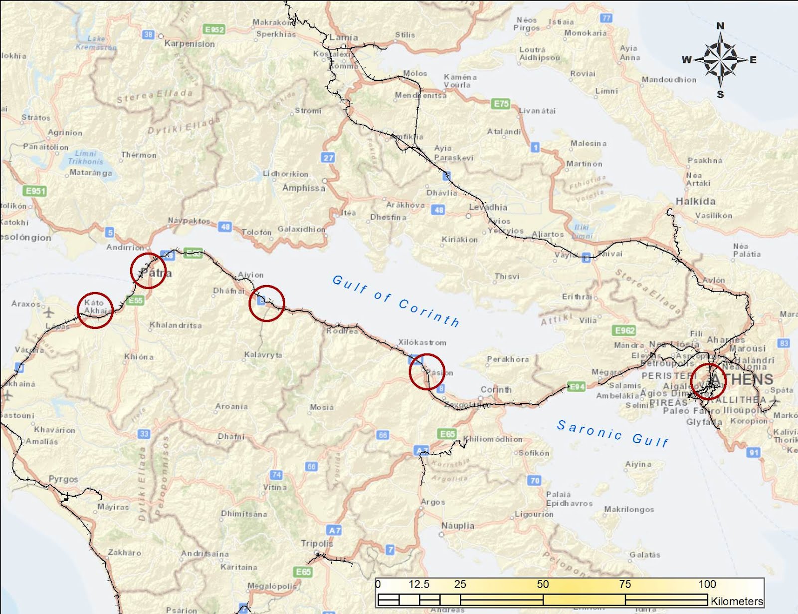
The circles show locations of photographs. Background maps from ESRI Maps and Data.

This is the station at Kato Achaia, a farming community west of Patras. It has a sleepy land-that-time-forgot look to it. The water tank for steam locomotives still stands. As I recall, the train was delayed and we sat at a café for an hour or two.

As of 1997, the train consisted of modern but well-used diesel-electric rail cars. The windows were open and the train trundled along through vineyards and orange groves.

In Patras, we had to change trains for the main line to Athens. This was a busy station because tourists from Italy disembarked from ferry boats and many boarded the train here.

You see some refugees or gypsies on a bench. A historical note: After the Communist Bloc collapsed in 1989, thousands of Greeks from Bulgaria, Romania, and other countries were finally free to return home. Some had been stranded in the Soviet Union since the 1917 revolution. In Czarist Russia, Greeks were an important part of the merchant class and traveled throughout the vast land, but when the Bolsheviks imposed Communism, the Greeks were unable to leave. Many of their descendants spoke no Greek and had not been able to worship in Orthodox churches. After 1989, Gypsies (the Roma) also were able to travel across borders that had formerly been sealed. Finally, Albania, once a forbidden dictatorship every bit as secretive as North Korea is now, collapsed, opening the borders to thousands of impoverished Albanians who desperately wanted to find work in Greece. The people on the bench may be gypsies. These refugees have caused major disruptions to Greek society and its fragile economy.

This "Splendid" hotel was across the street from the Patras rail station. It was probably clean enough but noisy; I will pass.

The next major junction was Diakopto, where tourists could take the famous rack train up the gorge to Kalavrita (subject of a future blog).


This is the station in Kiato, closed as of 2011 because the new, regular-gauge train had been extended this far west. This station looked clean and modern, and the Ο.Σ.Ε. administration must have spent money on it only a few years before it was superseded by the new line.


Further east, we see the station at Nerantza, probably not used in decades. I used to vacation near here, and from my sister's house we would hear the trains periodically rumble by. One engineer was distinctive because he tooted the horn more than other train drivers. Continuing east, the train would have stopped in the city of Korinthos, featured in the previous blog article.

Then the train crossed the narrow Corinth Canal (Διώρυγα της Κορίνθου), which connects the Gulf of Corinth (Korinthiakos Kolpos) with the Saronic Gulf (Saronikos Kolpos). The canal, dug in the 1890s, is narrow and mostly used by cruise boats. This photograph, looking down on the railroad bridge, was taken from a relative's helicopter in 1999, using Kodachrome 25 film in a Leica  M3 rangefinder camera with 50 mm f/2.0 Summicron lens.

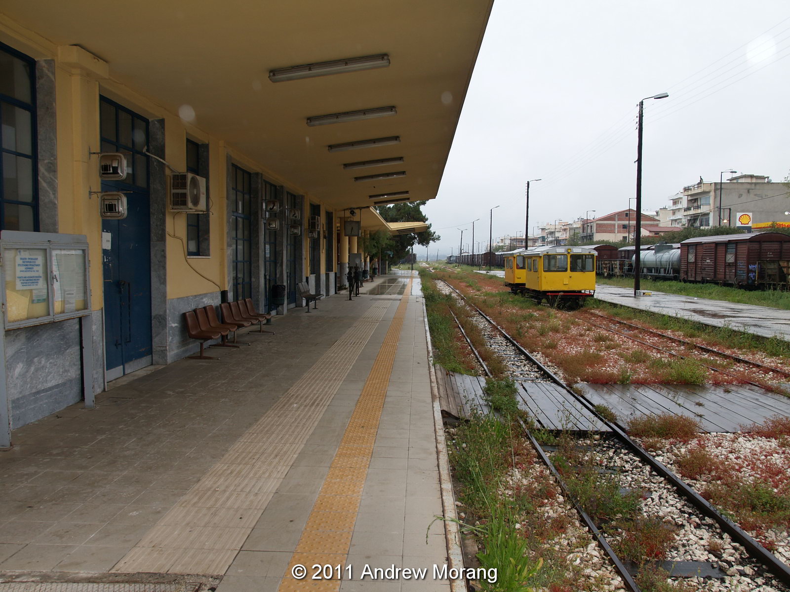
Finally, after chugging through the industrial suburbs of west Athens, we reached the Peloponnese Railroad Station on Sidirodromon Street (built in 1889). It was pretty sleepy in 1997 and some men were sitting around playing backgammon and drinking coffee (Greek gents do a lot of this). I think the station is now unused and am not sure what its fate will be.

For some photographs of abandoned steam locomotives from the Peloponnese system:
http://www.retronaut.co/2011/10/abandoned-steam-engines-argolis-greece/

Photograph notes: The square black and white frames are scans of Kodak Tri-X Professional film exposed in a Rolleiflex 3.5F camera (medium format 120-size film) with 75mm f/3.5 Zeiss Planar  (5-element) lens. I developed the film in Kodak HC-110 developer at dilution B. Tri-X has a characteristic look that has never been excelled. The Kiato photographs were from an Olympus E-330 digital camera. Digital is much easier, but film is more distinctive and requires a methodical approach.

Sunday, February 5, 2012

The Athens to Peloponnese Railroad Station, Corinth, Greece

Dear Readers, this is the first of five posts about railways in Greece.

The Piraeus, Athens and Peloponnese Railways or SPAP (in Greek: Σιδηρόδρομοι Πειραιώς-Αθηνών-Πελοποννήσου or Σ.Π.Α.Π.) was founded in 1882 to connect the port of Piraeus (Πειραιεύς) with Athens and the Peloponnese region of southern Greece. The late-1800s was the era of great railroad building throughout the world. Greece, at that time a poor nation with isolated market towns and limited roads, hoped to support economic development by building a rail system. The Peloponnese line reached Corinth in 1885 and Patras in 1887. SPAP was absorbed by the Hellenic State Railways in 1962, now called OSE (Greek: Οργανισμός Σιδηροδρόμων Ελλάδος or Ο.Σ.Ε.). The Peloponnese rail was narrow-gauge 1,000 mm (3 ft 3 ⅜ in.), in contrast to the continental-standard 1,435 mm (4 ft 8 ½ in.) used in most of mainland Greece. The line from Piraeus to Corinth was 99 km long. In the 1890s, it was the fastest way to make the journey, the alternate being a steamship trip.


The postcard, from Wikipedia, shows the old station in Corinth (or Korinthos) in 1910. The map shows the location (background street map from ESRI maps and data). During the mid-20th century, tourists arriving from Italy typically took a ferry boat from one of the Italian Adriatic ports to the city of Patras, where they disembarked. Then the SPAP train took them on a leisurely day-long ride to the old central rail station in Athens. Once the modern highway was built in the 1960s, many travelers took diesel buses instead. As a result, they rushed past the charming little market towns clustered along the shore of the Gulf of Corinth and missed the train experience.


Today, the rail station in Corinth on Dimokratias Street stands semi-abandoned. As of 2005, the modern suburban rail connects the Athens Elefthérios Venizélos (Ελευθέριος Βενιζέλος) International Airport with Corinth and, now continues further west to the town of Kiato. Eventually, the modern rail will extend all the way to Patras, and the rest of the historic 1-m gauge train will be discontinued. As part of its financial restructuring, the Greek government plans to privatize the Ο.Σ.Ε., but I do not know if there are any potential buyers.


This station looks like it is late-1940s or 1950s-vintage. Corinth was badly damaged by an earthquake in 1928, and possibly that eventually necessitated a new station. Another hypothesis: The railroad suffered extensive damage during the second World War, and maybe the original station was damaged.


In 2011, the rail yard was pretty quiet, with abandoned rolling stock sitting on sidings. The arm sticking out in front of a graffiti-covered box car is an old water tap for filling the tenders of steam locomotives.

Finally, these mechanical control units actuated track switches. Oddly, they were on the platform in front of the station waiting room. Wouldn't tourists be tempted to fiddle with them? It's strange they had never been electrified or adapted to control from a central control room. I will show more examples of the railroad in a future blog entry.

All photographs taken with an Olympus E-330 digital camera using the Olympus 14-54mm f/2.8 lens, tripod-mounted.

Thursday, January 26, 2012

Shotgun Shacks on Grammar Street, Vicksburg, Mississippi

Grammar Street is another one of those semi-hidden streets in Vicksburg that most people do not know exist unless they live there or have a specific reason to visit. There are two parts to Grammar. The east section is approximately parallel to Harrison Street and runs from Court Street to the Stout's Bayou. There is no bridge, but on the opposite side, Grammar Street picks up again and proceeds uphill to the west to Martha Street. See the circled areas on the map.
The photograph above shows the opening to Grammar street when standing on Court Street. This little house is still present but has been painted since I took the photograph in 2000.
The east part of Grammar was once a typical Southern "court," lined with identical shotgun shacks. The white house being engulfed with trees is no. 1318 and has been demolished.
Proceeding west, we come to nos. 1314 and 1312. Obviously, 1312 was a mess and ready to be demolished.
The next two were nos. 1310 and 1308. The latter is still standing.
No. 1306 had the faded green paint.
No. 1304 was already gone in the early 2000s, when I took these photographs, but 1302 was present. In the 2003 photograph, 1302 was pretty rough looking, but by 2006, it had been painted and had flowers on the front porch.
No. 1300 was the last house before you reach Stout's Bayou. I am not sure if it ever floods on this part of the street. (Update January 2021: All of these little cottages have been demolished.)
Across the street is a cottage, which may be no. 1301. All in all, this was a pretty rough street. Around the corner on First North, I met a lady who grew up on Grammar. She said she remembered when a bus would come to pick up workers to go to the cotton fields. She thought that was 30 years ago, but I think it must have been at least a decade earlier because by 1980, most cotton harvesting was mechanized.
Across the bayou to the west, the neighborhood was a bit higher grade and older, possibly late 1800s. The tall handsome house is no. 1228, and is still standing. (Update January 2021: this house is gone)
No. 1213 is more modern. Vicksburg has more hidden streets like this steeped in history.

Film note: These are all scans of Kodachrome 25 transparency film. The first photograph was taken with a Minox 35 compact camera, the rest with Leica rangefinders using Leica Summicron lenses. Kodachrome 25 was the finest-grain transparency film, and it really shone when you used the best prime focal length lenses (like Leica) to record fine details. But, its slow speed almost insured that you had to use a tripod. Some photographers disliked Kodachrome, but it had a unique color palette and rewarded deliberate workers. It also had excellent archival properties, and the colors remain vivid for decades.

Scanning Note: I scanned these on a Nikon Coolscan 4000 at 3000 dpi and saved them as TIFF files. It is difficult to scan K25, especially if the frames contain dark areas. With a Nikon unit, you have to manually increase the gain significantly. Also, the color balance is difficult to correct at dusk. Unlike modern digital camera, color film recorded the color as it was. If the day was overcast and the light was cool (blue), the pictures looked blue. Commercial photographers used color-correcting filters, but most documentary photographers did not bother.

Tuesday, January 17, 2012

1923-vintage Bungalows on First North, Vicksburg, Mississippi

First North is one of Vicksburg's historic streets, running north-south in the eastern part of the city. At the junction with Harrison Street, it continues south with a new name, Court Street.
On the east side of First North, the line of bungalows at 1511-1517 have a common ancestry. (They are outlined by the circle on the map.) A friend at Mississippi Department of Archives and History sent me this text from the Vicksburg Evening Post, June 13, 1923, about these homes:

MODERN HOMES AT MODERATE PRICES THROUGH SWITZER
Something About Bungalows in First North Street

Within about four weeks, perhaps the first of the modern, moderate priced bungalows being constructed by Louis Switzer, First North Street, between Harrison and South will be completed and placed on the market.

Mr. Switzer is to build five of these houses--six room bungalows. Each home will include a living room, dining room and a kitchen, two bed rooms, bathroom, hall and sleeping porch.

There will be gas, electricity, water, and all the sanitary conveniences.

Mr. Switzer is planning to sell these homes for a price between $1,000 and $5,000, and he will sell on an easy payment basis.

Lumber for the houses is being secured by Mr. Switzer from his own mill at Oak Ridge, high grade poplar and gum being used for the framing.

Purchases Truck

For hauling the lumber from Oak Ridge to Vicksburg, Mr. Switzer has just purchased a truck. Owning his own sawmill and getting his lumber at cost will enable Mr. Switzer to build the new homes at a cheaper figure than would otherwise be the case.

"I am building these homes for the average man," Mr. Switzer said commenting on his plans. "Every man, of course, ought to own his own home, and I will make it possible for this average man to secure a cozy, comfortable home at a price that will be within his reach."

J.W. Sacks is the contractor building the bungalows for Mr. Switzer.

Mr. Switzer announces that his First North street bungalow proposition is to be something new in Vicksburg. It will be a complete "move in" affair. His new homes are to be completely furnished--furniture, fixtures, stove, everything set up ready for occupancy.

After a man buys one of these homes all he will have to do to feel at home is to enter the bungalow and hang up his hat.


Now only four of the bungalows still stand, The southernmost one, at the corner of First North and Harrison was torn down at least a decade ago. The lot is now a garden. The photograph above shows no. 1517, presently the southernmost unit.
Moving north, the second house is 1515, with a cheerful paint job.
The third house is 1513, still with its original porch but with modified posts.
Finally, the northernmost unit is 1511. It has been renovated and has a larger attic than the other bungalows. I talked to a lady who lived in this house and she told me she grew up in the neighborhood. She formerly lived on Grammar Street, which is a block away and will be the subject of a future blog entry.

(Digital images taken with a Panasonic G1 digital camera with a Lumix 14-45 mm lens.)

Tuesday, January 10, 2012

Cotton Compress, Levee Street, Vicksburg, Mississippi

For many years, a complex of brick and steel sheds stood on the west side of Levee Street close to where the historic Fairground Street bridge crosses the Kansas City Southern railroad yard. This was the cotton compress, address 2400 Levee Street (see the circle on the map).
This post card, circa. 1911, is from the Ann Rayburn Paper Americana Collection, Special Collections, University of Mississippi Libraries (originally from the International Post Card Co., New York, N.Y.).
This is a glass negative from the George Grantham Bain Collection at the Library of Congress, with title, "Louisiana Flood 1912, Cotton Compress at Vicksburg as a refuge." I am not sure if any of these buildings still stand.
According to a December 17, 2010, article in The Vicksburg Post, the compress facility dates to 1903 and formerly housed a cotton gin and 13 warehouses and sheds with about 340,000 square feet of storage space. The view above was taken from the top of the levee looking east at about the same location as the 1912 flood photograph. Vicksburg is on the hill in the distance.
These two views show part of the complex from Levee Street. The Post did not specify how long the compress had been unused, but the buildings were in poor shape because of water damage and asbestos exposure following years of vacancy. Notice the sign on the ground with scripture.
This press was under the tower in the upper photograph. I do not know the mechanics of how it worked, but I remember seeing steam and activity in the 1980s, when this was still a going concern.
A developer told the city's Board of Architectural Review that the Vicksburg Compress company planned to use some of the buildings as a self-storage facility. Other buildings would be demolished, and the 1940s water tower would be removed because it was unsafe.
The interior had typically interesting industrial archaeology to examine (and I like exploring places like this). Notice the large wood timbers holding up the roof.
The grimy old workbenches still had tools, pipe, and cans of chemicals strewn about.
You could even wash up...maybe.
Someone had stored some old American muscle cars, but they were in no better condition than the buildings.
While I was exploring on a December day in 2010, a small team was cleaning up bricks and loading them on pallets.
As of December 2011, many of the brick walls are gone, and I assume the bricks have been sold. But the steel sheds are still unused, and the water tower is still standing. These projects tend to take a long time in Vicksburg.

An interesting article on cottonseed oil mills is in:  Wrenn, L. B. 1994. Cotton gins and cottonseed oil mills in the New South. Agricultural History, Vol. 68, No. 2, Eli Whitney's Cotton Gin, 1793-1993: A Symposium (Spring, 1994), pp. 232-242. (Published by: Agricultural History Society)

These are digital images from a 10 megapixel Sony R-1 digital camera, tripod-mounted. The interiors were multi-second exposures, good examples of how well-suited digital cameras are for low-light conditions. You no longer have to worry about reciprocity failure and color shifts as with film; just set the exposure and let the shutter stay open as long as needed. The R-1 has a superb Schneider lens.

Some black and white Panatomic-X film photographs of the compress are in my 2018 article (please click the link).