Monday, July 4, 2016

Burmese Days 21: NaPyar, the Odoriferous Fish Village

While driving from Rangoon eastwards towards the Golden Rock, our driver took us along a short stretch of the Yangon-Mandalay Highway, then turned right on the Maylamyaing Highway (NH8).

Historical note: the Yangon-Mandalay highway was originally surveyed and laid out by an American engineering company, Louis Berger & Associates, in 1961, under the sponsorship of the U.S. Army Corps of Engineers (Moorhus and Grathwol, 1992). Initially, conditions seemed to be in place for construction bids to be let, but planning and economic assistance for the project ended in 1963, a victim of deteriorating domestic politics in Burma and worsening relations between the United States and Burmese government. The expressway was finally built by the Burmese between 2005 and 2010, with some funds generated by exporting natural gas to Thailand.
At Waw Village, we stopped for a rail crossing. The train trundles along at a leisure pace because of the rough condition of the track bed. We could see the cars swaying back and forth, I suppose likely to generate cases of mal de mer (or mal de chemin de fer?).
A short distance east of Waw, our driver stopped at NaPyar Village. This is low terrain, crisscrossed by canals and rivers. It reminded me of southern Louisiana. On the barge just off the bank, piles of fish were drying in the sun.
The aromatic dry fish are neatly piled on tables at roadside stands. In the photograph above, the leaves are used to wrap betel nut (chewed by ladies and gents alike).
The lady even uses a pole with hook to neatly organize the fish curls on hooks.
I was impressed by the amount of business these stands attracted. Maybe the Vicksburg farmers' market needs a dried fish stand.
This sturdy gent was mashing up fish remnants in a giant pestle. Afterwards, the mush was poured into a clay pot, sealed, and left to ferment for an unknown amount of time. The resulting fish sauce (juice) was sold in gallon-size glass jugs at the roadside stands. Think of this the next time you buy oriental fish sauce at the supermarket.

Photographs taken with a Fuji X-E1 digital camera.

References
Moorhus, D.M. and Grathwol, R.P. 1992. Bricks, Sand, and Marble: U.S. Army Corps of Engineers Construction in the Mediterranean and Middle East, 1947-1991. Washington DC: US Government Printing Office, 660 p. (available online, http://www.history.army.mil/html/books/bricks_sand_and_marble/CMH_45-2-1.pdf)

Blogger note:
I am trying to overcome the problem with photographs not uploading into the blog. Based on suggestions from other bloggers around the world, I removed all the EXIF data from the photographs. For now, the photographs are all appearing, but there is still some issue with the Google servers because for five years, all jpeg files uploaded successfully.

Wednesday, June 29, 2016

Blogger is Temporarily Sick - Now is OK again

Dear Readers,

Blogger is ill. No, not me, I'm fine other than being old. But the servers that serve the blog articles are failing to upload some of the photographs. It may have something to do with Google's migrating their Picasa Web Albums to Google Photos. The photographs that you see in these posts are stored in Picasa Web Albums, up to 2000 photos per album. But when I open my albums, I see that some photographs no longer appear but have a placeholder instead with a small question mark (?) in a box. Google is, hopefully, working on the problem. In the meantime, sorry for the inconvenience.

July 9 update: By removing the copyright symbol © from the EXIF data in each photograph, the photograph will upload and display properly. I have been re-uploading photographs from some of my older posts. 

July 21 update: All photographs appear again. Google did some change to their software, and photographs with odd characters in the EXIF fields display properly, just as they did before.

Saturday, June 25, 2016

Burmese Days 20: The Golden Rock of Kyaiktiyo

One of the pilgrimage sites of profound importance to Buddhists is the Kyaiktiyo Pagoda (Burmese: ကျိုက်ထီးရိုးဘုရား) in Mon State of southeast Burma. Most westerners know it as the Golden Rock because the actual pagoda is a small structure perched on the top of a granite boulder. The boulder has been covered with layers of gold leaf over hundreds of years by devotees, and it glows gold in the setting sun. According to legends, the Golden Rock itself is perched on a strand of the Buddha's hair, and indeed, the rock is said to rock very slightly. Considering that Burma is in an earthquake zone, I can't understand why it has not rolled down from its precarious perch.

The lower photograph is half of a stereo frame from Wikimedia Commons, "Kyaitteyo Pagoda, miraculously balanced by a hair of Buddha, on Kelasa hills, Burma", Date: 1900, Author:  Underwood and Underwood (in the public domain).
The rock and the pagoda are at the top of Mt. Kyaiktiyo. To reach the mountain, you drive to the town of Kin Pun Sakhan and board a lorry which has been outfitted with benchseats in the bed. Then the lorry grinds up the Golden Rock Mountain Road in caravan with other lorries. Much of the road is single-lane, so the lorries wait at sidings for other trucks going the other way. Finally, you reach the plateau area and disembark. The first impression is not very auspicious - sheds for the trucks, vendors of food and souvenirs, trash. Hmmm...
The vendors sell some strange food. Centipedes? Fish and cakes of unknown grain(?) or protein(?).

The upper reaches are accessed by steps after you pay an entry fee. Two large lions guard the entrance to Kyaiktiyo Pagoda, and from here on, you must be barefoot, which was difficult for my wife.
Families camp up on the marble platform. We met some adorable children. They look healthy, intelligent, and alert.
Monks discuss and smoke.
Models pose for photographers. This is an interesting place; like the Swedagon in Rangoon, almost a merger of religious site and country fair.
At dawn, families wait for the sun to cast on the Golden Rock.
Pilgrams donate food and lay it out neatly along the railing next to the rock. It makes quite a mess, and I am not sure if the food is for monks or if it is cleaned up and discarded daily.
Looking north, you can see that the entire mountain top is covered with restaurants and guesthouses. I think these are mostly for Burmese visitors, while Western tourists stay in a couple of hotels on the south side. We stayed at the Mountain Top Hotel, which was decent and had rooms with private bath. The setting with view to the east was sublime.
Finally the ride back downhill in the lorry, squashed in with as many people as they can fit. Truly, the Golden Rock is unique, and if you visit Burma, take a side trip to Kyaiktiyo. It takes about 4 or 5 hours to drive from Rangoon, and you need to charter a car and driver and pay for hotel and food. But just do it.

Photographs taken with a Fuji X-E1 digital camera, Nexus 4 phone, and on Tri-X film with a Leica M2 camera.

Thursday, June 16, 2016

Condemned in Vicksburg, Mississippi

On May 28, a short article in the Vicksburg Post listed six houses that would be razed. The article (quoted below) said these would be the first houses demolished since 2014. I took a quick trip around town to check on the properties and record them before they were gone and forgotten. I have also included photographs of other houses torn down recently.
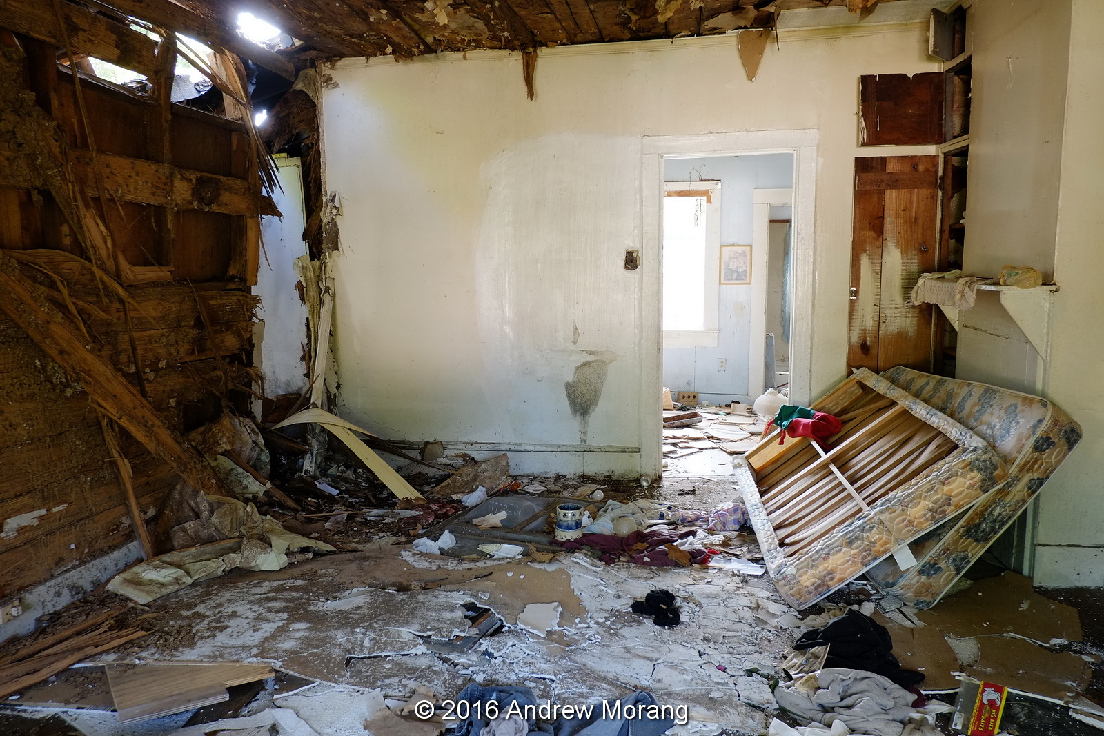
No. 2511 Cedar Street is a cottage at the corner of Military Ave. and Cedar Street. Part of the building suffered a fire.
The inside was a mess with papers strewn about and an abandoned mattress.
Bridge Street is one of Vicksburg's oldest neighborhoods. It is on a hill just north of the Kansas City Southern railroad cut and south of the hill that one held a water tank, now replaced with a cell tower. Most of the cottages appear to be late-1800s. No. 809 was a cottage made of concrete blocks cast in the form of limestone blocks. The vines were taking over. I spoke to the lady who lived to the left, and she complained about the jungle infringing on her lot.
The inside was a mess, there had been a fire, and some of the roof collapsed. Note the beautiful fireplace tiles. These should be recycled. And notice the lath under the plaster walls. As of June 14, the house is gone.
This is an example of the concrete blocks with a rough texture pattern like limestone. Note that this was hand-mixed concrete that used rounded river rock in the aggregate.
On the lot to the right (east), the cheerful yellow wood house at 815 Bridge burned in 2013 and was torn down.
Heading northeast, 605 Howard Street is a bit hard to find, at the junction of Howard and East Main Streets. This is another example of a condemned house where the former inhabitants may have left in a hurry, leaving possessions behind.
The inside looked reasonably intact.
No. 1633 Jackson Street was a trailer. These are common in the county but rare within the city limits.
Next door, 1617 Jackson Street was almost covered with vines but was not on the demolish list in the Vicksburg Post article.
This is a 2012 photograph of Jackson Street looking west with the cottage at 1617 on the right, not yet engulfed by vines.
Stouts Bayou crosses under Jackson Street here, passing through a 1920-vintage brick arch. Much of the riverbed in the bayou needs cleaning and re-concreting, but the City has been unable (or unwilling) to obtain right-of-way for access.
Jumping back to 2014, this was a derelict store at 2728 Drummond, also right next to Stouts Bayou.
In 2015, an old house at 1520 Marcus Street burned. It is another historic Vicksburg neighborhood that has lost numerous houses in the last 15 years.
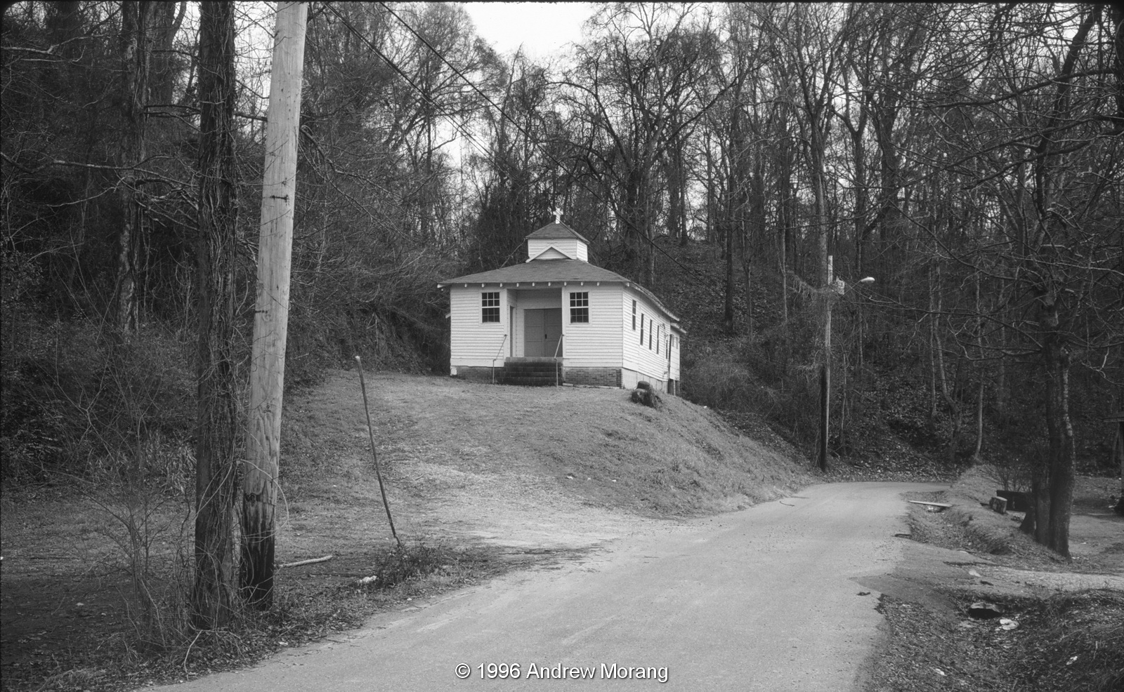
This church has been at 906 Yazoo Street for many years.
This is the same church in 1996 (from an Agfa Scala slide taken with a Leica M3 camera). This neighborhood is south of Army-Navy Drive, beyond the City of Vicksburg's shops and garages. Many of the houses have been demolished and there simply are fewer residents in this area than there were decades ago.
No. 840 Buck Street is also gone. This is a 2010 photograph taken on Kodak Panatomic-X film with a Fuji GW690II camera.
As I wrote in a previous article, all these cottages on Marys Alley have been demolished. They were in a flood zone and were inundated whenever the Mississippi River rose above approx. 47 ft on the Vicksburg gauge. This is also Panatomic-X film.
No. 1412 Jackson Street was a nice Victorian cottage in another one of Vicksburg's historical neighborhoods.
Finally, I did find one 2015 demolition in my photographs. This was a brick-fronted cottage at 816 Walnut Street. My friends and I saw the tractor at work on a Sunday when we rode by on bicycles.

Among the recent group of demolitions listed in the Post, I missed the house at 1216 Fayette Street before it was razed.

The 2012 and 2016 photographs were taken with a Fuji X-E1 digital camera; the older black and white photographs on film. A few others were from a Nexus 4 phone.


Board votes to raze six buildings
Published 10:27 pm Friday, May 27, 2016

Six vacant and derelict buildings in the city will soon be going down.


The Board of Mayor and Aldermen Wednesday approved contracts with two construction companies totaling $23,150 to raze the houses, which city officials have said are a threat to the health and safety of their neighborhoods.


“All of these houses have been approved by the board for demolition,” said Community Development Director Victor Gray-Lewis.


The six buildings, at 605 Howard St., 1633 Jackson St., 809 Bridge Street, 2511 Cedar St., 906 Yazoo St. and 1216 Fayette Street, are the first to be taken down since 2014.


The board has been hiring private contractors for several years to raze houses targeted by the city for demolition. The companies submit bids on the projects and the lowest bids for each project are selected.


The city at one time used public works employees to take the structures down, and charged property owners a fee based on a combination of the employees’ hourly rate and the cost of using the equipment. The equipment charge was based on a fee scale used by the Federal Emergency Management Agency to reimburse local governments for using equipment to clean up after disasters.


The practice stopped because of an increase of project involving city infrastructure.

Sunday, June 12, 2016

Abandoned Sears Roebuck Warehouse, Vicksburg

Long-term Vicksburg residents remember when Battlefield Mall was the first mall in town. Sears Roebuck anchored the west end of the building, while other stores occupied the east end. When I moved here in 1985, only an ice cream shop and a drug store were left in the east section because the new Pemberton Mall had opened and most companies moved to the new location. But Sears was a full-line store and remained in its Battlefield location until about 1993 or 1994. The mall remained empty for a few years until the US Army Corps of Engineers Vicksburg District rented it, using it for office space.
If you were on Wisconsin Avenue, you could reach the Battlefield Mall by driving down a steep, narrow road called Battlefield Road (imaginative). The concrete building on the right was the Sears repair and parts center.
The parts and repair center was a rather severe brick and concrete building. For decades, it was one of the strengths of Sears that you could have their appliances and equipment repaired all over the USA and Canada. Their parts depots were amazingly well-equipped. And if you needed an item that was not in stock, it would be shipped to your local repair center at no additional shipping cost.
The building is closed and locked - fate unknown. And it has not been vandalized from what I could tell. Can anyone use such a warehouse in a town that is de-constructing?
Surprise: the old Battlefield Road has been dug up, as part of a project to make a connector road between Wisconsin Avenue and North Frontage Road (from the Vicksburg Post).

Most photographs taken with a Fuji X-E1 digital camera, except for the last frame, which is from a Nexus 4 phone.