Monday, October 18, 2021

Southern Utah Road Trip - the Road West

Good-bye to Moab: La Sal Mountains (Manti-La Sal National Forest)

Long-term readers may recall that I took a long western USA road trip in 2016. I started in Redlands, California, where I imposed on my daughter and borrowed her station wagon for this trip (over 3,500 miles total). I followed Route 66 eastward as far as Albuquerque and Santa Fe and then joined friends in Moab. I wrote about Arches National Park, Canyonlands National Park, the Syncline Loop in Canyonlands, and the Volkswagen disposal yard/museum. After two weeks of hiking, good food, and fine companionship, I headed west and returned to California. 

This article will continue the road trip back to southern California through Utah and Nevada. 

Southern Utah is a wonderland of geology, spectacular vistas, mountains, and long miles between towns. Signs on I-70 warn you, "No services for the next xxx miles." Be sure you have plenty of fuel in your car as well as emergency supplies. 


Dawn on the Green River, Green River, Utah (2019 Tri-X photograph)
Fremont River, Capitol Reef National Park (2019 Tri-X photograph, Hasselblad camera)

For the first day, I drove west on I-70 and then on Utah 24 to Capitol Reef National Park, a fabulous location. Driving at 90 miles per hour at 7,000+ feet elevation pushed the little engine. After some hiking and a night near Capitol, I said good-bye to my friends and headed south on Utah's Hwy. 12 through the Dixie National Forest.


Dixie National Forest, Utah Rte. 12, approx. 9,000 ft elevation

Utah's Scenic Byway 12 is a fantastic drive. My car's little 5-cylinder engine worked hard at 9,000 ft elevation as I crossed a ridge in the Dixie National Forest. 

Grand Staircase–Escalante National Monument

Byway 12 then drops down into the Grand Staircase–Escalante National Monument. This is one of the nation's phenomenal visual treats, a remote landscape covering 1,880,000 acres where dinosaurs roamed and Native Americans drew art on rock faces. President Clinton designated this region as a national monument in 1996 to preserve cultural and scenic resources. The Trump administration reduced the area of the monument by over a half in a scummy attempt to spur a mining and coal boom, although the Utah Geological Survey concluded that the prospects of profitable minerals, tar sands, coal, oil, and gas were very limited (essentially non-existent). On October 8, 2021, President Biden restored the original boundaries of the monument.


The little town of Escalante, in the Potato Valley, is a center for recreation. Route 12 passes right through town, and it is one of the few locations to buy some food or gasoline. The Peoples Exchange on 115 North Center Street is an early-20th century general merchandise store. The building may house occasional art exhibits.


Too pooped on Main Street, Cannonville, Utah

Keep driving west on 12 and you reach Cannonville. It's tiny, with not much there. But turn south on Kodachrome Road and head south through a rugged landscape to Kodachrome Basin State Park.


Kodachrome Road, Utah
Near Kodachrome Basin State Park

Kodachrome Basin State Park is a wonderland of rock spires and canyons revealing 180 million years of geological history. In 1948, a National Geographic Society expedition gave the name Kodachrome to this area after the popular color film.


I returned to Rte. 12 and then went south on 63 to Bryce Canyon National Park. What an amazing terrain of rock pinnacles and spires.  Beware, it is crowded during the peak tourist season.


Route 9, the Zion-Mount Carmel Highway
Court of the Patriarchs (sandstone monoliths), Zion National Park

Continuing west, I drove on the historic Zion-Mount Carmel Highway into Zion National Park. CCC workers in the 1930s cut many of the tunnels along this twisty mountain road. The park is another geological wonder, very popular with international tourists. If you want to visit the main canyon, you must park in one of several lots near the entrance and take a shuttle bus. I took the bus up into the canyon and walked much of the way back to the parking lot. I stayed in the nearby town of Springdale in a funny little cabin, like a remnant of an old-fashioned motor court.


"I am a citizen, not of Athens or Greece, but of the desert...." 
The Mad Greek, Baker Blvd., Baker, California

Heading west out of Zion, the next stop is the city of Las Vegas. I had not been there before and was singularly unimpressed. Much of the city is dumpy and dirty but may have some decent urban decay topics. However, I needed a restroom and used a very elegant one at a casino. And they gave me some iced sparkling water. 

Continuing southwest out of Las Vegas on I-15, the terrain is rather dull desert. But stop! Quick, take the exit at Baker. There are Greeks in the desert! And they will serve you Greek coffee and baklava or a giant sandwich. Ahhh...

I have written before about some of the remnants of Route 66 in eastern California (click the links):

This ended my 2016 road trip. I can't wait to head out west again.

Wednesday, October 13, 2021

Ultimate and Massive Urban Decay: Angkor, Cambodia (Part 2)

Angkor Wat


The monumental temple of Angkor Wat is huge in every possible dimension. The central towers were taller than the steeples of Notre Dame. Angkor Wat defies the imagination. How did they build this? How did the emperors pay for it? How much of the city-state's annual GDP went to construction and maintenance? From Wikipedia,

Angkor Wat (/ˌæŋkɔːr ˈwɒt/; Khmer: អង្គរវត្ត, lit. 'temple city / city of temples', located in northwest Cambodia, is the largest religious structure (temple complex) in the world by land area, measuring 162.6 hectares (401+3⁄4 acres). At the centre of the temple stands a quincunx of four towers surrounding a central spire that rises to a height of 65 m (213 ft) above the ground. The temple has three rectangular galleries, each raised above the next. It lies within an outer wall 3.6 kilometres (2+1⁄4 miles) long and a moat more than five kilometres (three miles) long.

The temple was built at the behest of Suryavarman II in the early 12th century in Yaśodharapura (យសោធរបុរៈ, present-day Angkor), the capital of the Khmer Empire, as the state temple for the empire. Originally constructed as a personal mausoleum for Suryavarman, dedicated to the Hindu god Vishnu in the early 12th century, it was converted to a Buddhist temple towards the end of the 12th century.

Moat at Angkor Wat
Monumental guard lions at Angkor Wat. Do these look like Egyptian sculptures?

The carved lions guarded the monumental entryways. It is not hard to understand how the regal lion was used as a symbol of royalty and power from Egypt to Mesopotamia to Angkor to China.  

Celestial dancers, second level gallery

Thousands of these bas relief maidens line the halls. Every one is individual, but the feet are always sideways. According to the excellent and readable description of Angkor Was in tourismcambodia,

The starkness of the exterior of the second level gallery is offset by the decoration of the interior. Over 1,500 Apsaras (celestial dancers) line the walls of the gallery offering endless visual and spiritual enchantment. These graceful and beautiful females delight all visitors. They were crated by the Churning of the Ocean of Milk.

When one first walks into the courtyard the multitude of female figures on the walls and in the niches may seem repetitive but as one moves closer and looks carefully one sees that every one of these celestial nymphs is different, the elaborate coiffures, headdresses and jewellery befit, yet never overpower, these 'ethereal inhabitants of the heavens' Apsaras appear at Angkor Wat for the first time in twos and threes. These groups break with the traditional of decoration kin other part of the temple by standing with arms linked in coquettish postures and always in frontal view except for the feet, which appear in profile.

Note the amazing snake motif hairstyles. Also note that the big toe on the left foot is raised. I wonder what the symbolism is for the toe?

Waiting for the selfie, Angkor Wat
le coq sportif and the Celestial Dancers
Ah, the contemporary lovelies. But the big toes are not pointing up. And the hair is a bit boring.

Siem Reap


Siem Reap is the main urban area south of the temple complexes and is the location for most (or all ) hotels. It has an international airport to support the tourist trade.


Wait a minute. There is a temple with a pool in Siem Reap? Oh, no, this is just the Sokha Angkor Resort. It looks like the Cambodians still believe in monumental architecture. 

Dorky Americans in Siam Reap
Typical lunch

Extensive breakfast buffets, attentive and utterly polite staff, immaculate cleanliness - this is the life. Many of the other hotels in Siem are similarly spectacular. They put to shame what we call "luxury" hotels here in USA, let alone the quality of the cuisine.

The black and white scenes are digital images from an Olympus E-330 4/3 camera. I applied a pseudo Ektachrome simulation using DxO 5 software, which created the subtle selenium/purple tone.  

Thursday, October 7, 2021

Ultimate and Massive Urban Decay: Angkor, Cambodia (Part 1)

Ankor temples from tourismcambodia.com

Introduction

One of the most total and overwhelming examples of the collapse and disappearance of a civilization is the Khmer Empire (Khmer: ចក្រភពខ្មែរ) or the Angkor Empire (Khmer: ចក្រភពអង្គរ), whose remains are in present-day Cambodia. The empire thrived from the 9th - 15th centuries, during which the emperors developed a society of immense wealth and sophistication. At its peak, the capital, Angkor, covered 1000 square miles. The empire depended on a highly sophisticated water supply system consisting of reservoirs and canals. The reservoirs stored water during the monsoon and distributed it in the dry season. Some evidence shows that the large ponds surrounding the palaces had fish aquaculture. The city state grew in population until it exceeded 1 million, far exceeding any European city at the time.


Moat at Ankor Wat. Was this once used for fish aquaculture? Note the perfect linear steps.

As written in Wikipedia

"Its greatest legacy is Angkor, in present-day Cambodia, which was the site of the capital city during the empire's zenith. The majestic monuments of Angkor — such as Angkor Wat and Bayon — bear testimony to the Khmer empire's immense power and wealth, impressive art and culture, architectural technique and aesthetics achievements, as well as the variety of belief systems that it patronised over time. Recently satellite imaging has revealed Angkor to be the largest pre-industrial urban center in the world."
What caused the collapse? Common hypotheses include:
  1. Warfare (as an example, the destruction the Inca and Aztecs)
  2. Environmental degradation and collapse (Easter Island)
  3. Political decay and inability to maintain the colossal infrastructure
  4. Disease or a pandemic
  5. Demographic changes (i.e., low birthrates or mass migration)
Does possibility 3 sound like the path down which we are heading in USA? We have:
  • Political paralysis
  • Massive crumbling infrastructure
  • Money squandered on foreign wars and transfer payments
  • Corruption in the highest offices of the government as well as local governments
  • Looming water shortages in areas that are over-populated considering their natural resources (i.e., much of the US West)
  • A portion of the population in open revolt against the central government
Other major city-state complexes around the world collapsed, sometimes in a surprisingly short time (only years or decades). The Olmecs of Mesoamerica - little is known of them. The Maya abandoned their homes and just disappeared. The Inca collapsed in a few years in the face of Spanish invasion and the subsequent disease. The Nazca disappeared; there is no sign of them other than their colossal patterns in the desert. The Indus or Harappan civilization is gone. Cairo and the lower Nile valley may be the lone survivor of long-term habitation. Possibly sophisticated city life is just a temporary phase in human development - it starts and thrives for a period with great ambition and energy and then crumbles apart catastrophically. The Wikipedia article on Societal collapse makes for good reading. 

The incredible complex of temples, ruins, and giant smothering trees at Ankor is one of the world's great photographic topics. The stones, rocks, carved faces, and encroaching jungle are endlessly fascinating. Lara Croft: Tomb Raider and Indiana Jones and the Temple of Doom include scenes filmed here.
 

Temple of Ta Prohm

 
Local man climbing spire at Ta Prohm
Stone columns, Ta Prohm

From Wikipedia
"In 1186 A.D., Jayavarman VII embarked on a massive program of construction and public works. Rajavihara ("monastery of the king"), today known as Ta Prohm ("ancestor Brahma"), was one of the first temples founded pursuant to that program. The stele commemorating the foundation gives a date of 1186 A.D." 
After the Khmer Empire collapsed in the 15th century, Ta Phohm was neglected and the jungle slowly engulfed the complex. What happened to the priests and the 100,000 villagers who at one time served the temple complex? Archaeologists have left this temple largely unrestored, although some walls have been stabilized to prevent further collapse.


As you can see, the roots of these huge trees have engulfed the ancient walls, like some fantastic giant octopus crawling over the walls. From Wikipedia,
"The trees growing out of the ruins are perhaps the most distinctive feature of Ta Prohm, and "have prompted more writers to descriptive excess than any other feature of Angkor." Two species predominate, but sources disagree on their identification: the larger is either the silk-cotton tree (Ceiba pentandra) or thitpok Tetrameles nudiflora, and the smaller is either the strangler fig (Ficus gibbosa) or gold apple (Diospyros decandra). Angkor scholar Maurice Glaize observed, "On every side, in fantastic over-scale, the trunks of the silk-cotton trees soar skywards under a shadowy green canopy, their long spreading skirts trailing the ground and their endless roots coiling more like reptiles than plants."
 No wonder filmmakers like to shoot scenes here! Think of these tentacles in your sleep.
 

Temple of Banteay Srei

 
Detail of carved sandstone, Banteay Srei
Door ornamentation at Banteay Srei. Note the sophisticated figurine carving.

From Wikipedia
"Banteay Srei or Banteay Srey (Khmer: ប្រាសាទបន្ទាយស្រី) is a 10th-century Cambodian temple dedicated to the Hindu god Shiva. Located in the area of Angkor, it lies near the hill of Phnom Dei, 25 km (16 mi) north-east of the main group of temples that once belonged to the medieval capitals of Yasodharapura and Angkor Thom. Banteay Srei is built largely of red sandstone, a medium that lends itself to the elaborate decorative wall carvings which are still observable today. The buildings themselves are miniature in scale, unusually so when measured by the standards of Angkorian construction. These factors have made the temple extremely popular with tourists, and have led to its being widely praised as a "precious gem", or the "jewel of Khmer art."


Monumental entry hall, Banteay Srei
Guardian lions, entry hall, Banteai Srei. Do these look Egyptian to you?

Just imagine the monumental cost of mining, transporting, carving, and erecting all this stone. And look at the astonishing quality of the rock carving. Did the workers have early-technology steel tools for this work? How did the Khmer emperors/kings afford these projects? 

To be continued.....

Appendix - Background information from BBC

Beyond Angkor: How lasers revealed a lost city

By Ben Lawrie
Documentary film-maker

  • Published
  • Deep in the Cambodian jungle lie the remains of a vast medieval city, which was hidden for centuries. New archaeological techniques are now revealing its secrets - including an elaborate network of temples and boulevards, and sophisticated engineering.

    In April 1858 a young French explorer, Henri Mouhot, sailed from London to south-east Asia. For the next three years he travelled widely, discovering exotic jungle insects that still bear his name.

    Today he would be all but forgotten were it not for his journal, published in 1863, two years after he died of fever in Laos, aged just 35.

    Mouhot's account captured the public imagination, but not because of the beetles and spiders he found.

    Readers were gripped by his vivid descriptions of vast temples consumed by the jungle: Mouhot introduced the world to the lost medieval city of Angkor in Cambodia and its romantic, awe-inspiring splendour.

    "One of these temples, a rival to that of Solomon, and erected by some ancient Michelangelo, might take an honourable place beside our most beautiful buildings. It is grander than anything left to us by Greece or Rome," he wrote.

    His descriptions firmly established in popular culture the beguiling fantasy of swashbuckling explorers finding forgotten temples.

    Today Cambodia is famous for these buildings. The largest, Angkor Wat, constructed around 1150, remains the biggest religious complex on Earth, covering an area four times larger than Vatican City.

    It attracts two million tourists a year and takes pride of place on Cambodia's flag.

    But back in the 1860s Angkor Wat was virtually unheard of beyond local monks and villagers. The notion that this great temple was once surrounded by a city of nearly a million people was entirely unknown.

    It took over a century of gruelling archaeological fieldwork to fill in the map. The lost city of Angkor slowly began to reappear, street by street. But even then significant blanks remained.

    Then, last year, archaeologists announced a series of new discoveries - about Angkor, and an even older city hidden deep in the jungle beyond.

    An international team, led by the University of Sydney's Dr Damian Evans, had mapped 370 sq km around Angkor in unprecedented detail - no mean feat given the density of the jungle and the prevalence of landmines from Cambodia's civil war. Yet the entire survey took less than two weeks.

    Their secret?

    Lidar - a sophisticated remote sensing technology that is revolutionising archaeology, especially in the tropics.

    Mounted on a helicopter criss-crossing the countryside, the team's lidar device fired a million laser beams every four seconds through the jungle canopy, recording minute variations in ground surface topography.

    The findings were staggering.

    The archaeologists found undocumented cityscapes etched on to the forest floor, with temples, highways and elaborate waterways spreading across the landscape.

    "You have this kind of sudden eureka moment where you bring the data up on screen the first time and there it is - this ancient city very clearly in front of you," says Dr Evans.

    These new discoveries have profoundly transformed our understanding of Angkor, the greatest medieval city on Earth.

    At its peak, in the late 12th Century, Angkor was a bustling metropolis covering 1,000 sq km. (It would be another 700 years before London reached a similar size.)

    Angkor was once the capital of the mighty Khmer empire which, ruled by warrior kings, dominated the region for centuries - covering all of present-day Cambodia and much of Vietnam, Laos, Thailand and Myanmar. But its origins and birthplace have long been shrouded in mystery.

    A few meagre inscriptions suggested the empire was founded in the early 9th Century by a great king, Jayavarman II, and that his original capital, Mahendraparvata, was somewhere in the Kulen hills, a forested plateau north-east of the site on which Angkor would later be built.

    But no-one knew for sure - until the lidar team arrived.

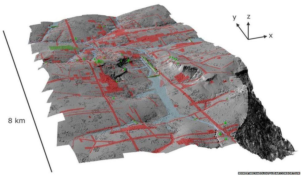
    The lidar survey of the hills revealed ghostly outlines on the forest floor of unknown temples and an elaborate and utterly unexpected grid of ceremonial boulevards, dykes and man-made ponds - a lost city, found.

    Relief map of MahendraparvataLidar technology has revealed the original city of Angkor - red lines indicate modern features including roads and canals. Image copyright Khmer Archaeology LiDAR Consortium

    Most striking of all was evidence of large-scale hydraulic engineering, the defining signature of the Khmer empire.

    By the time the royal capital moved south to Angkor around the end of the 9th Century, Khmer engineers were storing and distributing vast quantities of precious seasonal monsoon water using a complex network of huge canals and reservoirs.

    Harnessing the monsoon provided food security - and made the ruling elite fantastically rich. For the next three centuries they channelled their wealth into the greatest concentration of temples on Earth.

    One temple, Preah Khan, constructed in 1191, contained 60t of gold. Its value today would be about £2bn ($3.3bn).

    But despite the city's immense wealth, trouble was brewing.

    At the same time that Angkor's temple-building programme peaked, its vital hydraulic network was falling into disrepair - at the worst possible moment.

    The end of the medieval period saw dramatic shifts in climate across south-east Asia.

    Tree ring samples record sudden fluctuations between extreme dry and wet conditions - and the lidar map reveals catastrophic flood damage to the city's vital water network.

    With this lifeline in tatters, Angkor entered a spiral of decline from which it never recovered.

    In the 15th Century, the Khmer kings abandoned their city and moved to the coast. They built a new city, Phnom Penh, the present-day capital of Cambodia.

    Life in Angkor slowly ebbed away.

    When Mouhot arrived he found only the great stone temples, many of them in a perilous state of disrepair.

    Nearly everything else - from common houses to royal palaces, all of which were constructed of wood - had rotted away.

    The vast metropolis that once surrounded the temples had been all but devoured by the jungle.


    Friday, October 1, 2021

    Before the Crisis: Ciudad Acuña, Mexico, in 1982

    The Texas border city of Del Rio was in the news in September of 2021 because of the thousands of Haitian refugees who were hoping to enter the United States. Del Rio is in south central Texas on the Rio Grande. Across the river in northern Coahuila estado is Ciudad Acuña. The news stories reminded me that I spent a day in Ciudad Acuña in 1982 during a long road trip to Big Bend National Park. 

    Wash day in the Rio Grande, Ciudad Acuña, Mexico (Agfapan 25 film, Leica M3)

    Looking back, it felt like a simpler and more innocent time. We had no issues crossing into Mexico and then returning to USA. No one checked the car or asked us to open the trunk. We had our passports, but I cannot recall if the agent looked at them. I was surprised that there were no fences on the US side of the river, and, at least in July of 1982, anyone could easily cross the river. Ciudad Acuña looked rather sleepy. 


    Everyone we met was very friendly. Mexican families were washing their cars in the river, and the local kids were swimming and having a great time. I did not write down the location (my photo note-keeping was haphazard in those days), but I think this was at the Braulio Fernandez Ecological Park.

    Where is the traffic? Near Alpine, Texas.

    West Texas is big, lonely, and arid. You drive for hours and hours and see cacti and dry brush. Winter might be very scenic when snow drapes the terrain. It might be a bit cold, too.

    Big Bend National Park, Texas
    In or near Big Bend National Park

    Somewhere I have more negatives or slides of west Texas. Scanning them will wait for another day. 

    I took these photographs on Agfapan 25 film with a Leica M3 camera with 50mm ƒ/2.8 Elmar lens (Mexico scenes) or a Nikon F camera. Click any photo to enlarge it. I bought the M3 the year before in Buenos Aires, Argentina. It was a beater but served me for 25 years.