Thursday, April 6, 2017

Bikinis at the Bay of Pigs (Cuba)

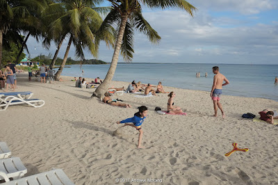
Checking out the scene, Playa Larga, Cuba
The US-sponsored invasion Bay of Pigs plays a large role in the history and mythology of the Cuban Revolution.
After reading about how the invading force flubbed up just about everything and how Cuban soldiers under the direction of Fidel Castro rounded up and arrested the demoralized invading force, I expected to see rusting military equipment and debris on the beaches at Playa Larga. Oops, now there are Europeans lounging around in small swim suits enjoying rum mojitos. Yes, I suppose even the Revolution must slowly adapt to the new economic reality.

The little town of Playa Larga, at the northwest tip of the Bahía de Cochinos or Batalla de Girón, was the Red Beach landing site for the CIA-trained paramilitary group Brigade 2506 on April 17, 1961. The beach proved to be floodlit, the boats grounded on coral reefs, and within three days, the Brigade 2506 was defeated by Cuban Army and militia forces. It was a tremendous embarrassment for President Kennedy, although the operation was hatched by the CIA and approved by President Eisenhower long before Kennedy began his term.
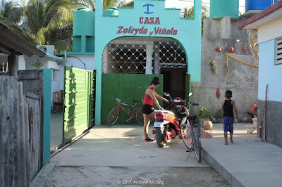
Then Playa slumbered, but is slowly transforming itself into a tourist destination. I am not sure if there are any hotels, but there are numerous casas particulares, which means private houses that have been certified to take in tourists. The one we stayed in was really more like a small inn rather than a private house, but someone on the staff did sleep in a tiny interior room. The staff was very courteous, the water was hot, towels clean, and our room faced the sea.
Despite the new tourists, much of Playa Larga looks like a place left in a previous time. The streets are sort-of paved. Local folks walk or take tricycle taxis. The rooster sings every morning (and much of the day and night, as well).
We walked around and came across a shop where the gents were restoring an old car. The next day it was gone, so I assume it ran on its own power. Cuban mechanics are pretty innovative considering the embargo for the last 50 years.
We were surprised that there was not much of a fishing fleet, just small open boats with outboards.
Propaganda in visitor's center at entrance to Playa Larga.
Victory billboard in Bermeyas, near the Bay of Pigs military museum.
Capitalist transportation in Playa Jardin 
Non-Capitalist transport in Playa Jardin
Playa Larga is fun enough, and we had wonderful weather without mosquitos. We were on a birding group, and the Zapata Peninsula is fabulous for bird-watching. But I'm not sure if I would go to Playa for a beach vacation.

These are digital images from a Fuji X-E1 digital camera.
Monday, April 3, 2017

Our Man in Havana 10: Nuevo Vedado (B&W film)

1950s flying saucer petrol station
The modern suburb west of Habana Centro is known as Nuevo Vedado. We stayed in a Casas Particulares, meaning a house in which the owner rents rooms to tourists. The one we were in was really nice, of modern 1950s modernist architecture with huge glass walls, It resembled a merging of a Mies van der Rohe glass house and one of Joseph Eichler's "California Modern" homes. In contrast to our challenging Park View Hotel downtown, we had immaculate modern US bathroom fixtures, hot water, clean towels, and excellent food. There were framed photographs of musicians and artists, who gather at the house.
There was even a hair service! Disadvantage: the house was a long way from downtown and we needed to use taxis.
As in downtown, there was a dearth of stores, at least on USA or European standards. I saw a pharmacy and a few restaurants, including the pollo snack bar on 26 Calle in the photograph above. I don't know if this was an example of the small-scale private industry that is now allowed now in Cuba, but it was busy.
Some of the apartment blocks reminded me of ones in Rangoon: lots of mildew creeping over the facade. I assume these were pre-revolution, meaning pre-1959. Despite some decay, this is a nice area. One taxi driver pointed out a house to us and said it is where Fulgencio Batista Zaldívar (the U.S.-backed dictator from 1952 - 1959) lived.
The playground on 41 Calle was pretty rough.

Dear Readers, we are done with our short tour of Havana and will proceed to other parts of Cuba. Stay tuned...

Tuesday, March 28, 2017

Our Man in Havana 9: the Cementerio de Cristóbal Colón

The Cementerio de Cristóbal Colón was founded in 1876 in the western suburbs of Havana, now known as the Vedado neighbourhood. Arellano de Loira y Cardoso, a Galician architect, built the cemetery and was also the first occupant when he died before his ambitious project was completed. Acording to Wikipedia, "Colon Cemetery is one of the great historical cemeteries of the world, and is generally held to be the most important in Latin America in historical and architectural terms, second only to La Recoleta in Buenos Aires."
The cemetery is full of ornate statuary and superb marble-work, similar to what I have seen in New Orleans, Louisiana.
There are also examples of 20th century Communist realism-style sculpture; workers toiling for the state type of symbolism. In this example, the man on the very left is carrying sugar cane, while the next man has bananas.
The man in this tomb is the Afro-Cuban singer and musician Ibrahim Ferrer Planas, who died on August 6th, 2005, at age 78. An Economist essay described his life and the revival of Cuban music around the world. Ferrer was one of the musicians in the “Buena Vista Social Club,” which sold 4 million copies worldwide and won a Grammy. In 2004, when Ferrer won the Grammy, the United States government denied permission for him to enter the U.S. to receive his award.

Photographs taken with a Leica M2 rangefinder camera on Kodak tri-X film. I developed the film in Kodak HC-110 developer and scanned the negatives with a Plustek 7600i scanner.

Tuesday, March 21, 2017

Our Man in Havana 8: The Central Railway Station

The Central Station in 1939, from the New York Times (http://www.nytimes.com/2012/03/18/realestate/cuba-streetscapes-the-new-york-accented-architecture-of-havana.html)
When I visit new cities, I like to check out the railroad station and train infrastructure. The main railway terminal in Havana is the Havana Central Station (Estación Central de Ferrocarriles) in the southern part of Habana Viejo. This handsome building was built in 1912 by the Frederick Snare Company of New York. Recall that in that era, big American companies dominated the Cuban economy and were improving the infrastructure to allow efficient movement of sugar cane and sugar products. After the 1958 revolution, the rail system was nationalized, and little or no funding was provided for upkeep or improvements to the system. In recent years, ridership had dropped rapidly, especially once new air-conditioned long distance busses started running on rural routes. The train is infamous for delays or breakdowns.
As of January 2017, the Central Station was undergoing massive rebuilding. I was not able to find out how this is being funded - by the Cuban government, the UN, or a grant from the Chinese government? Regardless, it was a closed construction site and I was disappointed to not see the interior.
The platforms are in the back (the west side of the building) and are still in use.
I tried to enter and take pictures, but a lady security guard tossed me out. But once I was outside the fence, she did not seem to care, or didn't pay any more attention (she was doing something with her phone).
The houses across the Avenida Bélgica face the station - it must have been a noisy spot.
We saw some rail infrastructure in rural area of Cuba. These tracks were in the village of Guasimal. The tops were not completely rusted, suggesting occasional use.

Photographs taken with a Fuji X-E1 digital camera. 

Friday, March 17, 2017

From the Archives: Sugar Land, Texas, in 1984 with Kodak Technical Pan Film

Sugar Land is a city southwest of Houston, Texas. Although Houston was inexorably sprawling in that direction in the 1980s, you still had a sense of countryside in Sugar Land. The town was surrounded by farmland and was known for the giant Imperial Sugar factory that occupied a multi-story complex of buildings and railroad tracks.


The Southern Pacific Railroad built the mission-style depot in 1927. It looked unused in 1984. I am glad to report that the depot was moved to 445 Commerce Green Blvd. and now houses the Chamber of Commerce. Good for them to reuse such a nice historic building.

Commemorative medal from the Sugar Land Heritage Foundation

This is a postcard of the Sugar Land sugar mill and nearby railroad lines in 1909. The depot was built to the left of where the men are standing on a locomotive. (From: (texashistory.unt.edu/ark:/67531/metapth1717/m1/1/: accessed March 2, 2017), University of North Texas Libraries, The Portal to Texas History, texashistory.unt.edu; crediting Fort Bend Museum).


I liked the old-fashioned farmhouses. Back then I did not take careful photo notes, so the exact location is unknown.


This old farm had asphalt shingle sheets for siding ("tar-paper shack").


More tracks and warehouses. I tried to identify the trailer company in the warehouse, but it may no longer exist.

I took these photographs in 1984 with a Honeywell Pentax Spotmatic camera with 55mm ƒ/1.8 Super-Takumar and 28mm ƒ/3.5 Super-Multi-Coated Takumar lenses. The 55mm lens is one of the late-1960s versions with a thorium element, which has turned slightly yellow with time. The film was the ultra-fine-grained Kodak Technical Pan film, which I exposed at EI 25. This was an emulsion developed for the military or for microfilming use. It was very contrasty unless you used the special Kodak Technidol developer, and even then it was hard to use. I only experimented with Technical Pan one more time, in Athens, Greece.

I scanned the negatives with a Plustek 7600i film scanner using Silverfast Ai software.

The Spotmatic is still in good condition, and I recently used it in Vicksburg with Tri-X film. As always, I am amazed at the superb quality of these mid-century optics.

Monday, March 13, 2017

Our Man in Havana 7: Courtyards and Entry Halls of Vieja

Walking along the streets in Havana, I noticed that many entryways led either into an inner courtyard or to a dingy mysterious common area and stairwell. They reminded me of entry halls in old apartment blocks in Poland. Kathmandu had hidden courtyards, as well. Let's take a short tour of Habana Viejo and Centro.
261 Aguiar in Habana Viejo. Questionable electrical wiring on the wall. What's beyond to the right?
Courtyard in 261 Aguiar. I don't understand the barrels - for rainwater?
Hall and stair at 512 Aguiar. Note that modern digital electrical meters have been installed on the left wall.
515 Cuba Street, with more of the modern digital electrical meters. The mess of wires strung above the meters is slightly non-code. Notice the complicated stairway going through the arch and then ascending behind it. 
507A Cuba, with a courtyard beyond.
265 San Miguel. Whatever building was once here has been cleared out.
Marble stairs at 212 Campanario. This was originally expensive construction. 
Entry hall at 202 Campanario. Note the tiles on the wall, similar to ones in subway stations (durable and washable).

I took these photographs with a Fuji X-E1 digital camera, with some RAW files processed in PhotoNinja software.

Wednesday, March 8, 2017

Our Man in Havana 6: the Paseo del Prado

Detroit Publishing Co., Publisher. [Hotel Pasaje and Prado, Havana, Cuba]. Cuba Havana, None. [Between 1900 and 1915] Photograph. Retrieved from the Library of Congress, https://www.loc.gov/item/det1994023933/PP/. (Accessed March 19, 2017.)
The Paseo del Prado, also known as the Paseo de Martí, is a boulevard with a tree-lined marble promenade running along the center. The Paseo divides Habana Viejo from Centro, and runs from the seaside Malecón south to the Capitolio. In the afternoon, the Paseo is the place to be seen, and a broad cross-section of Havana society congregates under the trees to walk, talk, sing, play music, skateboard, eat and generally foregather. According to Wikipedia, the Paseo was laid out in 1772. In 1925, Jean-Claude Nicolas Forestier, a French landscape architect, redesigned the it, lining it with trees and marble benches (Forestier? What a splendid name for a landscape architect.)
The Prado, circa 1921-1939, E.C. Kropp Co., Milwaukee, Wisconsin. In the Public Domain, Courtesy of Special Collections, University of Houston Libraries.
The chess champions, Paseo del Prado (Tri-X film)
As for fading architecture, you see some splendid examples along the Prado. Moorish architecture? In the Caribbean?
Neptuno view west.
Another view of Neptuno looking west
San Miguel
A street market on San Miguel. I assume this is an example of the small-scale capitalism that is now allowed. Some of the goods were for the tourist trade.
The side streets looking west into Habana Centro are pretty interesting. Really, you could spend an entire day along the Prado watching the people and exploring the side streets.

I took these photographs with a Fuji X-E1 digital camera, most with a Leica 50mm f/2.0 Summicron lens.

For a view inside some of these fading mansions, look at this January 2017 article titled "Inside Old Havana" in American Airlines' magazine, American Way. A German photographer, Bernhard Hartmann, met families who lived in these old houses and gained permission to photograph inside.