Showing posts with label Kodachrome. Show all posts

Tuesday, July 4, 2023

Abandoned Early Digital Technology: the Kodak Photo CD

Background


The great Eastman Kodak Company was an early pioneer in the technology and science behind digital imaging. Kodak scientists and mathematicians developed many of the early patents pertaining to digital imaging chips, data processing, and color management. The Department of Defense funded some of this early work. The popular press and photo "experts" in internet fantasy-land love to curse at Kodak and say how it totally missed the digital revolution. As usual, most of them have an agenda and the story is more complicated.

Kodak's managers, scientists, and engineers were fully aware of how digital imaging would eventually destroy their immense profit machine. Kodak made money from film production and selling supplies to photo-finishing companies around the world. These were high-margin disposable supplies that needed constant replenishing. Digital was totally different. It was based on the manufacture of cameras and peripherals (memory cards and software), a different economic model from Kodak's. 


Three Photo CDs from 1995. Note the handy index sheets.

What is a Photo CD?


During the transition period of the 1990s, Kodak tried to bridge both worlds with their Photo CD. From Wikipedia

Photo CD is a system designed by Kodak for digitizing and saving photos onto a CD. Launched in 1991, the discs were designed to hold nearly 100 high quality images, scanned prints and slides using special proprietary encoding. Photo CDs are defined in the Beige Book and conform to the CD-ROM XA and CD-i Bridge specifications as well. They were intended to play on CD-i players, Photo CD players (Apple's PowerCD for example), and any computer with a suitable software (LaserSoft Imaging's SilverFast DC or HDR for example).

You can read more details on this site.

To buy a Photo CD, you first had Kodak (or select laboratories) develop your film. Then they scanned your frames with proprietary Kodak scanners to a compact disk (CD). 

From Linotype-Hell Company technical note:

The Kodak Photo CD scanner uses a stationary tri-linear array (three linear arrays with a R,G, or B filter) of 2048 elements. It is designed exclusively for 35mm film. During scanning, the film is moved parallel to the long dimension of the frame. This results in a scanned data file of 2048 by 3072 pixels in R, G, and B per frame of 35mm film. Before this data is quantized for storage, several transformations are made to optimize the encoding of the data for various applications and to achieve data compression.

The primary consumer application for Photo CD is television display. Kodak therefore has chosen to refer to the TV display resolution as the Base image. This resolution is achieved by averaging 16 pixels in the original high resolution 16 Base image to create each single pixel at Base resolution. This averaging is done in a two-step process so that an intermediate resolution HDTV image (4 Base) is also available. In addition, since TV uses luminance/chrominance data, the scanner RGB data is mathematically transformed into a single luminance and two chrominance components before processing. Kodak identifies the particular luminance and chrominance that they use as PhotoYCCTM (or YCC for short).


Kodak PCD-860 player (by permission from an eBay listing by 68ra-53)

Kodak designed the system to allow customers to see their photographs on a television screen. Kodak sold several Photo CD playback readers that you connected to your television. But American analog NTSC (National Television Standards Committee) televisions in the 1990s had poor (OK miserable) color and dynamic range. To make the photographs look good on a television screen, Kodak's software expanded the color and dynamic range. I am not sure how the CDs were encoded to play back correctly on PAL or SECAM televisions. Possibly, the playback units for those markets did some software processing internally. 

I do not know if these players will work on current Digital Terrestrial Television (DTT) units that use the ATSC (Advanced Television Systems Committee) standards. 


Reading Photo CD Files


Many software packages, like Ifranview, will still open the .PCD files on the PhotoCD. But images often look washed out because of the exaggerated dynamic range. I think Kodak planned to offer a software to open the files on 1990s computers, but I have not been able to find a copy. Maybe this software was never offered to the public. Kodak recommended that applications use a Lookup Table (LUT) after converting the PhotoYCC data from the Photo CD into RGB. 

The problem lies in the fact that most modern programs do not have access to these Kodak lookup tables. Most software companies have long discontinued their packages that opened Photo CD files and properly corrected the color and dynamic range. LaserSoft no longer sells their SilverFast PhotoCD. pcdMagic may be the only currently-marketed software that runs on contemporary computers.  

An alternative: a Photrio reader wrote that Digital Light & Color Picture Window Pro 7 correctly opened the Photo CD format. Version 7 is now a free package. But only the 32-bit Windows Version 7 opens the Photo CD. I downloaded it onto a 64-bit computer running Windows 7 Pro, and Picture Window opened correctly. 

A minor issue: Picture Window needs the index files that are on the Photo CD. If you downloaded just the .PCD files to a hard drive, I think you cannot access them. Therefore, you need the original CD as well as a CD reader. If your computer does not have a CD drive, you must find/buy a portable unit or need to revive an older computer. (Hint: do not discard your legacy computers; you never know when you might need some of the old hardware or software). 


Skopelos, Greece


Hora (main town), Skopelos, Greece (Kodachrome 25, Leica M3, 50mm Summicron lens)
Hora, Skopelos (90mm ƒ/2.8 Tele-Elmarit lens)
How does my garden grow? Skopelos town (135mm ƒ/4 Tele-Elmarit lens)
My croissant is too small; Skopelos


Skiathos


Hangin' out in the sun, Skiathos
Waiting for departure, Hora, Skiathos
Kastro, Malaria Beach, Skiathos

The Kastro was the medieval fortified town on the very northern tip of Skiathos. It was settled in the 1300s when the islanders fled from the raids of Turkish pirates.

Morning in Skiathos


Mainland, Attica


Abandoned loading dock for minerals, Grammatikó (near Marathonas) (50mm Summicron, polarizer)


Summary


My experience with the Photo CD process was mixed. You can see that on many of these frames, the colors are exaggerated or a bit off. Some have a subtle color cast. For some Kodachrome rolls, the files on the CD were very good quality. But other CDs had poor exposures and colors. I think the Kodak automated scanner may have set color and gain for the whole roll based on the first slide. But if that slide was poorly exposed, and no technician inspected the process, the .PCD file for that first frame ended up looking good, but the rest of the roll looked poor.

Dark Kodachrome slides did not scan well. The dark areas were noisy and had a purple color cast. It is possible that the Picture Window Pro 7 software did not correct the colors quite right. And it is possible that being designed as a display media for NTSC televisions, the colors will never be "correct". I could do more adjustments with Photoshop, but that ends up taking a lot of time. It may be better to just scan from scratch with a film scanner.

I expect that C-41 negative film, such as Gold 100, would have transferred more successfully on the Kodak CD system. 

I did not use Photo-CD scanning after the late-1990s. And I never bought one of the viewing units for the television. Still, it was a clever interim technology. Eastman Kodak deserved credit for trying to integrate traditional film with the digital future.

Saturday, May 20, 2023

From the Kodachrome Archives: Athens and Central Greece in 1951

Background


My father moved to Athens, Greece in February 1951. He had just returned to USA from an overseas position in the Pacific, spent a week job-hunting in New York City and was offered this posting. He visited relatives in Boston and Orlando, bought a few supplies and clothes, boarded Pan Am, and left for Greece. He traveled light and efficiently (unlike his son).

Greece must have seemed exotic. But he had read classical literature, and Greek architectural features were popular in early 20th century American buildings. On weekends, he had time to explore. He sometimes had access to the company car and by mid-year, bought a new Chevrolet. 

He and other American engineers lived in hotels for a few months and then found apartments. He co-rented a flat near Kolonaki Square with two other Americans within easy walking distance to the office on Merlin Street. The flat came with a man-servant who did laundry and cooking. 

Here are some examples from approximately 1951 and 1952 (plus one from 1957). My dad did not label his slides, so I am guessing the dates based on his diaries. For some frames, I know the exact date because he wrote a detail like "went to the market with two cameras." At that time, Kodak did not print the processing date on the cardboard slide mount. He used his 1949 Leica IIIC camera with its 5cm ƒ/2 Summitar lens (both of which I still use 70 years later). 


Athens


Hadrian's Arch and the Acropolis
East side of the Parthenon. 
The Parthenon (built 447 to 432 BC).  

I remember when you could walk all over the Acropolis site and climb up into the massive temple. Today, visitors must walk on wooden boardwalks. The millions of tourists were literally wearing out the stone. 

Think of the awesome passage of history during which this temple has stood. Aristotle may have walked among the columns. More recent visitors have included Lord Byron, Winston Churchill, Harry Truman, Dwight Eisenhower, Princess Elizabeth, Agatha Christie, Vladimir Putin, Elizabeth Taylor, Margaret Thatcher, Barack Obama, and Bill Clinton. 


Checking out the Cariadids on the Maiden Porch of the Erechtheion.


As of 1957, these Cariadids were originals. But in subsequent decades, air pollution disfigured them and Greek authorities removed for safe-keeping, They are now in the Acropolis Museum. In their place are replicas based on an example in the British Museum. The one in London, taken to Britain by Lord Elgin, had been preserved indoors are was largely intact. 


Temple of Olympian Zeus (construction 6th century BC to 2nd century AD)


This scene has not changed much over the decades. There may be some tall building in the background now.


1994 view of the Acropolis and Phaleron Bay from Lycavitos mountain (Kodachrome 25, Leica M3 camera, 135mm Tele-Elmar lens)

This is a modern view of the Acropolis taken at dusk. 

Central Greece


According to my dad's diary, this was a 1951 4-door Chevrolet Sedan Skyline Deluxe. He ordered it from a Chevrolet dealer in Athens but paid by sending a check to General Motors in USA. It cost $1629 plus some extra for hubcaps and a spare tire. A ship delivered it, along with cars that other American engineers had ordered, to Piraeus. He got it out of customs on August 6, 1951.

I vaguely remember this Chevrolet. I used to stand up in the back (this was the era before we worried about car safety). I recall him telling me that in the early 1950s, only diplomats and Americans could afford to own cars. Recall, Greece was very poor because it had been looted by the Nazis during World War II and then suffered three years of brutal civil war. An automobile was a luxury item. Petrol was a luxury.

Somewhere in central Greece near Volos

Once, tourists dressed properly. Today, Americans look like homeless people.


View of Volos looking west

Pelion


Plateîa with Platanos trees, Zagora, Greece

Zagora is a cheerful mountain town perched on the Pelion Peninsula facing east towards the Aegean Sea. My grandfather's family came from Zagora, and the municipal office has records dating to the late-1800s. 


Lady of the Lake (stream), near Zagora, Pelion, Greece


Closing notes


Consider what an amazing amount of information is stored in these 70-year-old slides. And it is accessible! All you need to do is look at the slide with a magnifier. It is a time machine into the past. As long as the slides are not damaged by fire, flood, or fungus, some sort of optical device, like a camera with a macro lens, will be able to retrieve this image data for decades to come. Will our hard drives loaded with digital jpeg files be readable in 70 years? Will people look at a billion cell phone dump Instagram uploads on the "cloud" in 70 years? 

In those days, it was a challenge to get the Kodachrome processed. In that era, Kodak included processing with the purchase of the film. I remember my dad  telling me that he would give an exposed roll to an American who was returning to USA. The colleague would send the film to Kodak when he was back in USA. Then he would take the slides back to Greece or give the package to another American heading to Athens. He would also deliver fresh rolls of film. Turnaround must have been months. This would certainly not suit the modern Instagram generation. Greece is dry, which helped preserve these slides and retard growth of fungus.

I scanned these Kodachrome slides with a Plustek 7600i film scanner operated by SilverFast software. Most frames were almost perfect with the Auto CCR setting. On a few frames, I used the neutral grey dropper to correct the color. Afterwards, on some frames, I cleaned lint and splotches with the heal tool in Photoshop CS5. I resized for web display with XnViewMP. Please click any frame to see it magnified.


Saturday, February 18, 2023

From the Archives: Iraq in 1956

In the post-WWII era, Iraq looked like a progressive and advancing country, with active foreign trade, factories, major agricultural output, and (most important) oil. My dad worked on water supply projects there in 1956 for an American engineering company. I assume the work was funded by US-AID, as were infrastructure and water supply projects around the world. This was the short period when the USA was still seen as one of the victors and heroes of the war in Europe and Asia. We funded development projects around the world, fed a starving Europe, and shared scientific knowledge. These efforts led to the green resolution and the virtual elimination of small pox, tuberculosis, and polio. These were the good years before we ruined our reputation with the misguided interference in Latin America, the Bay of Pigs, and the disaster in Vietnam. 

In the 1950s, Iraq was awash with oil money. The government even commissioned Frank Lloyd Wright to develop a Master Plan for Baghdad. None of it was ever built, so my dad did not enjoy any of Wright's extravagant architecture (such as the opera house on an island in the Tigris!).


Tigris River from Zia Hotel

This is the view from the Zia Hotel, where my dad stayed. 


Agatha Christie lived in the Zia in 1928 and used it as a model for her Tia Hotel. 

Haydar Khana Mosque, Baghdad 
Super stewpot, probably the Souk al-Safafeer, Baghdad

Souk al-Safafeer was Baghdad’s ancient coppersmiths’ market.

Agatha Christie's heroine, Victoria, came across the Souk on her first day in Baghdad:

"And then, as she walked along the street, a prodigious hammering and clanging came to her ears and peering down a long dim alley, she remembered that Mrs. Cardew Trench had said that the Olive Branch was near the Copper Bazaar. Here, at least, was the Copper Bazaar.

"Victoria plunged in, and for the next three-quarters of an hour she forgot the Olive Branch completely. The Copper Bazaar fascinated her. The blow-lamps, the melting metal, the whole business of craftsmanship came like a revelation to the little Cockney used only to finished products stacked up for sale. She wandered at random through the souk, passed out of the Copper Bazaar, came to the gay striped horse blankets, and the cotton quilted bedcovers. Here European merchandise took on a totally different guise, in the arched cool darkness it had the exotic quality of something come from overseas, something strange and rare. Bales of cheap printed cottons in gay colours made a feast for the eyes."

Villagers walking past an archaeological site
Checking out the date harvest
Ruins of the Arch of Ctesiphon. Note the massive base.

Ctesiphon was an imperial capitol and rich commercial city on the east bank of the Tigris about 20 miles southeast of Baghdad. The arch is a famous tourist destination. 


Ruins of the Arch of Ctesiphon.

Note how a modern buttress had been built to keep the wall from toppling.

From Alamy via The Economist.

Early-to-mid-1900s passenger network, from The Economist

The Middle East once had a comprehensive network of rail lines. You truly could take the train from Berlin to Baghdad, and continue to Basra, or the line to Beirut, and hence on to Cairo or Medina. Most of it has fallen into ruin after a century of war, deliberate destruction, mismanagement, and bad governance. But select rail lines are being rebuilt. 

This ends our short visit to Baghdad. My dad's employer never signed a contract for hydrology projects in Iraq and we never moved there. It would have been an adventure.

My dad took these pictures on Kodachrome film with his Leica IIIC camera and its 5cm ƒ/2 Summitar lens, the same package that I occasionally use today.

Sunday, July 17, 2022

Back When it was Cool: Charles River, Boston, January 1968

Winter of 1968


With the summer midday heat here in Vicksburg hovering around 34° or 35° C (95° F), one thinks of cool. In my stuff (of which there is far too much), I found some Kodachrome slides of the frozen Charles River in Boston. I took these in January of 1968, when I did not know anything about photography but was excited by views and vistas. My grandmother was visiting (the lady from my Escape from Berlin article), and we went to the Top of the Hub observation deck in the Prudential Tower. I can't recall if we ate lunch up there. 

Charles River view west with Cambridge across the river
Charles River view northeast towards Charlestown with Longfellow Bridge in the center

The handsome multi-arch bridge is the Longfellow Bridge, built in 1901. A friend remembered how badly rusted the steelwork had become some 20 years ago. The structure received an almost total rebuild in the early 2000s. Beyond the Longfellow bridge is the Charles River Dam, on which is located Boston's Museum of Science.

Back Bay in foreground with the Charles Basin and MIT campus across the river

Decades ago, I taught sailing in the Charles Basin at Community Boating. This public sailing organization has run programs for adults and children here since 1946. Summer was lazy and laid-back. We filled baggies with water and threw them at other boats. During those sailing days, I sometimes walked across town to Durgin Park Restaurant for a cup of chow-dah and a 95 cent luncheon. Then home via the MBTA on Dime-Time (yes, only 10 cents).

In autumn, the winds picked up and the fun increased. If a boat went over, a motor boat came out to pick us up and right the capsized sail boat. Then they took us to a doctor in Back Bay who administered tetanus shots. There was none of that get permission from your parents stuff - you got a tetanus shot. How times have changed. 

But best of all, the Charles River has been drastically cleaned. Once a national scandal for its pollution, the river now hosts fish, eagles and other wildlife. This is a dramatic example of the benefits of federal waterway protections by means of the EPA's Charles River Initiative.

Topographic Notes


Let us step back into topographic history. Much of the flat land area today in Boston is artificial land fill. We often use the term "reclamation," as if we are reclaiming the land from the sea or river, waging battle on the evil forces of nature. 


Landfilling in Boston since 1630 has more than doubled the urban area (unfortunately, at the expense of destroying what must have been highly productive wetlands). The figure above is adapted from Rosen, Brenninkmeyer, and Maybury (1993).

The Charles River Basin and the neighborhood that you see in the snowy pictures above is artificial. The tidal river between Boston and Cambridge was formerly an expanse of mudflats which were exposed twice daily and renowned for mosquitoes and nasty aromas in summer. The original 1910 dam converted the basin into an agreeable fresh-water body, along which fashionable homes, a landscaped esplanade, and institutions of higher learning were located (Whitehill 1968). 


Museum of Science on original Charles River Dam

Little of the original dam can be seen because a busy highway crosses it and the Museum of Science was built on the dam in 1950. 

New Charles River Dam and pump house, completed in 1978

The new Charles River Dam is multi-function project. Not only was it designed to protect against unusually high tide or surge in Boston Harbor moving upstream into the basin but also to maintain a restricted range of water level in the Charles River Basin. Large pumps can pump rainwater and runoff from the river side of the dam out into the harbor side (on the left in the photograph). The pumps first operated during the Northeast Blizzard of '78. 

Back Bay in 1944, before construction of the Prudential Tower

The Back Bay has been Boston's most fashionable neighborhood since the marsh ands tidal flats along the original Charles River were drained and filled, with construction starting in 1859. From Wikipedia:
Setback requirements and other restrictions, written into the lot deeds of the newly filled Back Bay, produced harmonious rows of dignified three- and four-story residential brownstones (though most along Newbury Street are now in commercial use). The Back Bay is listed on the National Register of Historic Places, and is considered one of the best-preserved examples of 19th-century urban architecture in the United States. In 1966, the Massachusetts Legislature, "to safeguard the heritage of the city of Boston by preventing the despoliation" of the Back Bay, created the Back Bay Architectural District to regulate exterior changes to Back Bay buildings.
My wife's mother and parents lived in the Back Bay before World War II, but I do not know the address. If you worked in downtown Boston, this would be elegant and convenient.

Visit Boston, walk in the Back Bay, admire the fashionable and expensive stores, lunch at a bistro, have your hair done at a spa, and consider how history surrounds you.

References

Rosen, P. S., Brenninkmeyer, B. M., and Maybury, L. M. 1993. “Holocene Evolution of Boston Inner Harbor, Massachusetts,” Journal of Coastal Research, Vol 9, No. 2, pp 363-377.

Whitehill, W.M.  1968.  Boston, A Topographical History.  Second edition, enlarged, Belknap Press of Harvard University Press, Cambridge, MA, 299 p.


The snow pictures are from Kodachrome II film, probably taken with my dad's Canon rangefinder camera (unknown model) and its 50mm ƒ/1.9 Canon Serenar lens. My dad's 1944 Kodachrome is from a Perfex camera (unknown model).

Sunday, July 3, 2022

When We Were Young: Beach Surveys in Rhode Island

Introduction


Once upon a time, during a previous life, I conducted beach profile surveys for the State of Rhode Island and Providence Plantations (the long official name, as printed on my pay checks). A technician or other graduate student and I would drive to the beaches every two weeks and survey the shape of the foreshore as far as the water line. We would survey from eight monuments (posts) that had been driven into the sand on the backshore in the dunes. In summer, we waded a distance offshore. It was a lot of fun. Summers were sunny and easy, and we mysteriously needed a full day to complete the surveys. We became dark bronze from the sun. In winter, we bundled up and sometimes slipped on the sand if it was frozen. 

Rhode Island's south shore is less developed than the coasts of many other states. This is an offshoot of the damage wrought by the Great New England Hurricane of 1938. Waves and surge from the hurricane destroyed entire communities on the south shore. Afterwards, the state wisely zoned large stretches of the barrier islands and salt ponds to be preserved as nature reserves or wildlife sanctuaries. As a result, Rhode Island's beaches today are surprisingly clean and traditional. Developers were not able to rape the environment by building multi-floor condominiums or vast McMansion tracts (in contrast, see the horrors of coastal Florida, New Jersey, Alabama, and other states). 


At the beach


Peat chunks on Charlestown Beach, August, 1976 (Kodachrome 25 slide)

After a storm, pieces of peat sometimes get washed onto the beach. The peat formed in the quiescent salt ponds, which were protected from ocean waves by barrier islands. As the barrier islands and spits retreat, the peat gets exposed on the open ocean side and is vulnerable to being broken up into chunks. This is proof of the barrier island rollover mechanism by which rising sea level causes the barriers to retreat landward. 

Yes, we had rising sea level back in 1976. We still have it, despite denials by scumbag politicians (you guess the party). We also were beginning to study the effects of greenhouse gasses on heat trapping in the atmosphere and reflectivity of solar radiation.


House remnants from before 1938 hurricane, Charlestown Beach, August 1976
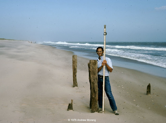
Mr. Michael Schneck at old pilings, Charlestown Beach, August 1976 

When I was a student in Rhode Island in the late 1970s, I talked to people who lived through the 1938 hurricane. The memories seared them. They told me that old-timers always knew that any house at the coast should be little more than a vacation cottage with the cast-off furniture from the city house. If the storm knocked it off its posts, move it back on some new posts and re-furnish it with new castoff fittings. They scoffed at rich city slickers who built grand permanent houses next to the beach. That was the 1970s! Just visit the Outer Banks, coastal Florida, parts of Alabama, and numerous other beaches to see the monstrosities erected by developers since then.

Dr. Dan Urish enjoying the view and lunch, East Beach, August 1976

What wonderful summer days. At campus, I swam every day at lunch out to the buoys in Narragansett Bay. 

Barge formerly buried for 85 years, Charlestown Beach, December 1976
Oops. No sun bathing this day, Charlestown Beach, January 1977
Semi-exposed barge, Charlestown Breachway, Charlestown Beach, January 1977

Winter at the shore is usually quiet. Bathhouses are forlorn, as if they are waiting for their cheerful summer visitors. I wrote about Rhode Island bathhouses in 2010. 

Mr. Steve Yokubaitis, Weekapaug Beach, January 1977

On this fresh scarp, you can see roots and rhizomes throughout the sand. This shows that this dune had been mature and stable for many years before storm waves removed the seaward section. The shore face (to the very right) is covered with cobble, which is common on this formerly glaciated terrain.  

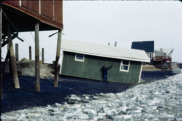
Charlestown Beach, January 30, 1977

Homeowners often hired contractors with bulldozers to push sand up to the houses. I think this was technically illegal, but do not recall if there was any legal action. 

Different states use different criteria to define private property versus public land. Public sand does not belong to private landowners, even if they think it is theirs to use. In effect, what is the definition of shoreline? Geographers and politicians have argued about this for over two centuries. If you are interested in the topic, NOAA has posted a list of shoreline references. Shalowitz' Shore and Sea Boundaries is a defining reference and summarizes technical and legal aspects of determining maritime boundaries in the United States. We will see more controversy related to shoreline definition as beaches retreat on most US coasts in the face of rising sea level (as a result of the climate change that millions of delusional Americans deny is underway).

In the next article, I will write about the Great New England Hurricane of 1938

Oops, sometimes we had to shovel the car out of the snow to get to the beach
Beginning of the great Northeastern Blizzard of '78 (flash photograph)

The Northeastern United States Blizzard of 1978 dropped record amounts of snow throughout New England. The Boston area was closed to outsiders for almost two weeks. We did not fare too badly in southern Rhode Island. We lost electricity, but we had down sleeping bags and did not have any issues. We cooked on a Bleuet GAZ camping stove. Those were the days.

The photographs above were all Kodachrome 25 or 64 slides, most from my Nikkormat FTn camera or my Leica IIIC, which I still use. I scanned them with a Plustek 7600i scanner operated with Silverfast Ai software.