Showing posts with label TMax. Show all posts

Monday, July 16, 2018

The Mississippi Delta 8b: The I.T. Montgomery House, Mound Bayou (B&W film)

Mound Bayou is a historic town in Bolivar County, Mississippi.
I.T Montgomery house, W. Main  Street, Mound Bayou, Mississippi
The always-informative Preservation in Mississippi blog recently wrote that the National Trust for Historic Preservation had announced its annual “America’s 11 Most Endangered Historic Places” for 2018. Isaiah T. Montgomery's House in Mound Bayou was on the list. From the National Trust:
"Isaiah T. Montgomery House Mound Bayou, Mississippi. Established by former slave Isaiah T. Montgomery, Mound Bayou was one of the earliest all-black municipalities, located in the Mississippi Delta following the Civil War. Today, Montgomery's home is in urgent need of stabilization and rehabilitation."
I wrote about Mound Bayou in 2012, and at that time, I.T. Montgomery's house looked intact, although I was not able to see inside.
Undated photograph of I.T. Montgomery house from Mississippi Department of Archives and History.
During an April 2018 drive through Mound Bayou, I saw some workmen installing heavy timbers abound the periphery of the house to prevent the walls from collapsing outwards. They did not know if other preservation work would follow. The lower floor of the house served as a clinic in the early 20th century.
Edwards Ave. (Old Hwy. 61), view south, Mound Bayou, Mississippi
Today, Mound Bayou looks rough and beat-up. The main road through town, Edwards Avenue, has the standard closed shops and shop-a-minute gas stations.
The former bus stop on Edwards Ave. is an early-20th century shop with square front.
Willie's transmission appears to be closed. You can see the I.T. Montgomery house a block away on the left.
This building at the corner of W. Main and Green Streets was the Bank of Mound Bayou, founded by Charles Banks in 1904, the first Black-owned bank in Mississippi.

The historic Taborian Hospital was closed for decades, then restored, and now is closed again. It is sad.

The history of Mound Bayou is a story of determination, back-breaking hard work, and a dream of creating a better life for African Americans in an era when they were treated brutally by the Southern white political establishment. National Public Radio featured Mound Bayou in one of their 2017 Our Land series. Booker T. Washington wrote a fascinating description of Mound Bayou's founding and early history in an article titled, "A Town Owned by Negroes, Mound Bayou, Miss., an Example of Thrift and Self-Government," July 1907 (archive from from Johns Hopkins Press).

The black and white photographs are from Kodak TMax 100 film, exposed with a Pentax Spotmatic camera (1971 vintage). I scanned the negatives with a Plustek 7600i film scanner controlled with Silverfast Ai software.

Wednesday, July 11, 2018

The Mississippi Delta 27: Itta Bena

Itta Bena is a small agricultural town a few miles west of Greenwood, in the central Mississippi Delta. The railroad goes through the center of town and once likely served as the town's main source of prosperity by carrying agricultural products to Greenwood or other markets.
Former Ralph Lembo store, Humphreys Street, Itta Bena
Humphreys Street parallels the tracks on the north. You can tell this was once a prosperous commercial strip with one- and two-story brick commercial buildings. Now many are closed and unoccupied. Of interest to Blues fans, the little store at 114 Humphreys Street was operated by Ralph Lembo in the 1920’s and 1930’s. He brought in many now-famous blues musicians. As of March 2018, the store was boarded up.
Front Street is south of the railroad tracks. Here, too, most of the shops are closed, but the L&T Food Market was active.
My friend, who is a professor at the Mississippi Valley State University just north of town, showed me a small building he called the Blue Store. I love the outside seating.

I took these photographs taken on Kodak TMax 100 film with a Pentax Spotmatic camera (1971-vintage). Many of the frames were with the 135mm f/3.5 Super-Multi-Coated Takumar lens (tripod-mounted). The light was harsh and glarey, difficult for architectural work. I scanned the negatives with a Plustek 7600i film scanner operated with SilverFast Ai software.

July 2018 update: Suzassippi wrote about the Ralph
Lembo store in Preservation Mississippi.

July 2021 update: Suzassippi has written two interesting articles about an Italian immigrant family that moved to Itta Been and operated a restaurant:  Part 1.  Part 2.  (click the links)

Wednesday, June 20, 2018

Mouldering away, the Levee Street Tank Farm, Vicksburg, Mississippi

A petroleum tank farm sits at the junction of Levee and Fairground Streets. The facility has been unused since before I moved to Vicksburg in the mid-1980s. For many years, the fence was intact and the gate closed. Then, for several years, I saw a "For Sale" by the General Services Administration sign. The GSA is the agency that manages real estate and other property (like motor vehicles) of the US Government. Then there were no signs at all for a few years.
Levee Street tank farm, April 7, 2018
In April, the gate was open, no one was around - it was too good to resist.
Former compressor building? 
The brick building on the right in the photograph above once must have contained compressors or other heavy industrial machinery. Evidence for this are the concrete supports, now semi-engulfed by vines and jungle. I have watched this building for years as its roof collapsed. 
View of Fairground Street Keystone Bridge, April 8, 1990, 4×5" Fujichrome transparency from Tachihara camera, 75mm f/8 Schneider Super-Angulon lens
Many years ago, my daughter and I climbed one of the metal stairs to the top of a tank. I carried up my 4×5"camera and tripod. There was a pungent smell of petroleum products coming from open valves. No one cared about fumes in 1990? From the top was a great view of the old Fairground Street Keystone bridge. The bridge still stands, but it has been closed to car and pedestrian traffic for 20 years and part of the approach on the west side has collapsed.
This is another 1990 view of tanks and piping, taken on Fujichrome 4×5" film with a 75mm f/8 Schneider Super-Angulon lens. Surprisingly, last week, when I biked by the site, I saw a fellow on a lawnmower cutting the grass. Someone is doing some maintenance there.

The 2018 black and white photographs are from Kodak TMax 100 film with a Pentax Spotmatic camera and the 24mm f/3.5 Super-Multi-Coated Takumar lens. This is fine early-1970s equipment. This version of the lens was made from 1972 to 1976, has 9 elements in 8 groups, and features multi-coating on the glass surfaces to reduce flare and reflections from the internal air-glass surfaces. I mounted the camera on a tripod.

Saturday, April 14, 2018

A River Flows through Kathmandu: the Bishnumati (Nepal 2017-13)


Two rivers flow through the Kathmandu Valley of Nepal. The main one is the Bagmati, which separates Kathmandu from Patan. It is considered holy by both Hindus and Buddhists. It rises in the Himalaya north of the Kathmandu valley and, after a major right and left turn in the city, flows generally south towards India through the Lesser Himalaya. The Bishnumati River also originates north of Kathmandu and flows through the western part of old Kathmandu. It joins the Bagmati in the southern part of the city about 3/4 mile south of Kathmandu Durbar Square. Both rivers are a mess. They have received  untreated sewage for decades, trash, old car bodies, and general detritus of a city without pollution controls.

Bishnumati River, view N from Swayambhu Marg Bridge

The view north from the Swayanbhu Marg bridge is rather discouraging. The river smells (OK, stinks), and there is trash and sludge in the water. The gravel berm or levee on the right in the water is perplexing. Is it to prevent flooding of some feature on the banks? A stream comes in from the left near the bridge in the distance. Possibly the berm is designed to prevent the flow from striking the bank on the right and causing erosion. Also note the broad gravel/sand bank on the left. The city maintenance workers should remove this gravel to allow the river greater flow capacity during flood.

Bishnumati River, view S from Swayambhu Marg Bridge

The view to the south is also discouraging. But there was a tractor digging in the gravel bank. I hope they intended to truck the material away. There are major brick works south of Kathmandu, and almost surely there are clay pits and excavations that could accept this excess riverine sediment.


About 1 mile west of the Bishnumati River is the Swoyambhunath Stupa. From the east, you ascend several thousand steps to the temple complex on a hilltop. It is a crowded scene with vendors, tourists, and Buddhists from many countries. The woods and general grounds are pretty trashy. Monkeys live in the woods and thrive picking food scraps.


I will only show two pictures from the main temple grounds of the Swoyambhunath Stupa. The site has shoulder-to-shoulder people. Many of the old buildings were terribly damaged by the 2015 earthquake. Most were made of unreinforced bricks, and the walls tumbled down in the earthquake. We saw construction crews laboriously rebuilding structures by hand.


I took the first three photographs on Kodak Tmax 100 film with my Leica IIIC rangefinder camera with 5cm Æ’/2.0 Summitar lens and a medium yellow filter. The scenes at the Swoyambhunath Stupa were from a Nexus 4 phone.

Thursday, April 5, 2018

Perched on the Heights: Chiwong Monastery, Solu Khumbu, Nepal (Nepal 2017-12)

Chiwong Monastery with Phaplu airstrip in the distance

Dear Readers, this is the last monastery that my friends and I visited during our circle trek in the Solu Khumbu. The Chiwong Monastery is perched on the edge of a steep mountain - almost a cliff - with a stunning view to the south. The town of Phaplu is in the distance, and the residents of the monastery can monitor the aircraft flying up the valley, making an abrupt turn, and dropping down onto the airstrip.

Chiwong Monastery has a web page:
The Chiwong Monastery was founded by the late Sangey Lama, in 1923. Sangey Lama’s ancestors, and all Sherpa people, have their origins in Kham, in northeastern Tibet. They migrated to the Everest region of the Solu Khumbu and made their home there, some 500 years ago.

At one time, the Chiwong Monastery echoed with the prayers and scholastic activities of the many monks and nuns that resided there. The monastery has a proud history, having been home to several spiritual leaders and learned monks. Chiwong Monastery had the privilege of hosting Dza-Rong-Phuk Sangey Ngawang Tenzing Jangpo, from 1955-1958. And, His Holiness Trulshig Rinpoche lived at the monastery from 1960-1967.
The monastery has a modern guest house built only a few years ago by an Italian organization. From the guest rooms, it was a steep walk uphill to the main buildings. I do not have any pictures of the older buildings. They were hard to capture because of the steep topography, but in the first photograph, you can see the complex from the ridge top.
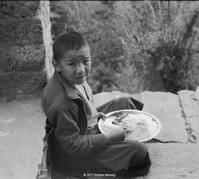
This monastery also serves as a school for boys of various ages. Most eat in a group, but at every meal, 3 or 4 of the younger boys eat with the older monks to socialize them to the upper echelons of the establishment.
We has some of the best food on our trek here. We were invited to eat with the senior monks.
The Lepon (aka Abbot) of Chiwong Gompa was a humble man who rose to that position from a village background. As a boy, he had trained at the Buddhist Academy in Serlo (described in an earlier post). His personality and personal philosophy led to his rise to the top and his approach to running a monastery full of young students. My friend, Don Messerschmidt could converse with the Lipon because both spoke village-level Nepali. The Lipon told us he had been to New York. That must have been quite a cultural and noise shock.
As usual, the kitchen offered some interesting scenes with hard side-lighting. The middle frame of the young man washing his hands had a light leak or some bad flare.
Some of the younger students had their dahl baht outside on the porch. I noticed they were using spoons rather than their fingers.
The monastery also fed our porters. The kitchens in these monasteries are big operations, as you have seen in my various pictures from this and other Nepali monasteries.

The black and white photographs were from Tmax 400 film exposed in my 1949 Leica IIIC camera with a 5cm Æ’/2.0 Summitar lens. I used a Gossen Luna Pro Digital light meter to measure the light.

Thursday, March 22, 2018

Learning and Peace, the Himalaya Buddhist Academy of Serlo (Nepal 2017-10)

The Himalaya Buddhist Academy at Serlo, in the southern Solu Khumbu, perches on a sunny hillside at 2870 m elevation above the town of Junbesi. The Tibetian name is Ngagyur Sergon Lungrig Sheddup Zungdel Ling (Higher Buddhist Studies and Research Center). Ven. Khenpo Sangye Tenzin (1924 - 1990), a scholar and teacher who had trained in Tibet, founded the academy in 1959. After the brutal Chinese invasion of Tibet, many monks and scholars fled south to Nepal and set up schools or monasteries to preserve Buddhist teachings and traditions. The traditional Kathmandu to Everest Base Camp trail comes by the front of the monastery, so the monks and students see many tourists in the trekking seasons.
My friends and I hiked up from Junbesi on a cheerful sunny day. The students were glad to see us. They were especially impressed because my friend, Don Messerschmidt, speaks fluent Nepali. We received the royal treatment, including tea and Digestive Biscuits.
Some of the boys were practicing to make torma from barley flour and water. The torma is decorated with butter sculpture, known as chopa. The boys practice making shapes such as disks, dots, lunar crescents, and flower petals.
The more skilled boys make amazingly intricate shapes. In the lower picture, a teacher is grading them on their workmanship.

The students come from Nepal, India, and occasionally from further away. Many Nepali families send their children to be trained at the monastery. At about age 18, they can opt to remain or leave and return to the regular commercial world. They live in dormitories on site.
The monastery is partly self-contained. The monks and students grow vegetables and barley on the hillsides. And they make their clothes on sturdy treadle sewing machines.
Once again, the kitchen was an interesting place, with shiny pots and mugs and very directional light. In this monastery, the cook is a professional contractor, not a monk. They use some gas, which is brought in. A road links the monastery to Junbesi, so trucks can bring in supplies.

The black and white photographs are from Kodak Tmax 400 film taken with my 1949 Leica IIIC rangefinder camera and a 5cm Æ’/2 Summitar lens.