Thursday, May 12, 2011

Stop Log Flood Gates in Vicksburg

Friends and coworkers have expressed interest in the temporary flood gates that the City of Vicksburg workers install to hold back the water. The concrete floodwall lines the Yazoo Canal along the Vicksburg waterfront. It runs from near the mouth of the canal (where it enters the Mississippi River) northward to Grove Street, then turns east and ends as Grove Street runs uphill.

There are several gaps in the floodwall to allow access to the river. The widest gap is where Levee Street runs north-south at the Grove Street junction. The railroad tracks also run through here. To block this opening, the city workers have to cut the tracks, dig up part of the pavement, and install steel I-beams. They have to dig up the street each time they anticipate a flood high enough to need the temporary barriers. It's a bit clumsy because afterwards, they have to repave the street. I expect they fill the hole with dirt and just add a thin layer of asphalt. Wood beams (stop logs) are placed in the I-beams and sealed with tar and oakum. In this photograph, you can see the 1907 railroad depot on the wet side of the barrier and can see a section of railroad track that was removed.


The temporary barrier is simple and effective against low flood levels. I have seen it hold back a half meter of water. This will be the test to see how it works with 2 m! Some water seeps through and pumps move the runoff back over the concrete wall some distance to the south (near the casino).


This last photograph shows Grove Street. Most of Vicksburg is on the bluffs and therefore safe from flooding. Compared to the early 1900s, when the entire Vicksburg waterfront was lined with shops, foundries, ship chandlers, and manufacturing plants, there is less at risk now if the waterfront were to be inundated.

Tuesday, May 10, 2011

Before the Crest: the Great Mississippi River Flood of 2011 in Vicksburg

The water is rising and, as of May 10, 2011, has exceeded all historical river elevations in Vicksburg. Fortunately, unlike a tsunami situation, there has been plenty of warning about the approach of the flood crest and industries and the City of Vicksburg have been preparing.

The Anderson Tully wood products company was inundated in the 1973 flood. A retired worker told me that it took five years to dry out the timber. To prevent future flooding, the company built a levee around the mill after 1973. But for the last week, a fleet of trucks has been delivering dirt and clay, and the levee is being extensively raised. The photograph above was Sunday, May 8.

Redwood Elementary School, in Redwood, north of Vicksburg, was vulnerable to water backing up a creek that runs behind the school. To protect it, the school department hired a contractor to build a levee. This was a significant berm, over 2 m high for much of its extent.

The students evacuated the school and will finish the year at another facility. They piled books and materials in the auditorium (Friday, May 6).

Most of Vicksburg was built on the loess bluffs, high above the river. The city waterfront, where steamboats unloaded and warehouses were located, historically flooded. To protect the waterfront, the Corps of Engineers built concrete flood walls early in the 20th century and greatly expanded them after the 1927 flood, which overtopped the earlier walls. But roads and railroads need to pass through the wall in several locations. These gaps in the walls are plugged with wood timbers held in place by steel I-beams. The city workers have to dig down into the pavement to find the anchor points for the I-beams. The timbers are sealed with oakum and tar and chained down (Friday, May 6). Later, the city workers found that plastic sheeting was more effective at preventing seepage.

I have never before seen the timber walls installed to their full height, flush with the concrete walls. The timbers have never been tested to hold back three meters of water. The gate above is at Levee Street near the old railroad depot. Sadly, the depot, which is being renovated to become part of the river museum, is on the unprotected side of the flood wall.


The Ford subdivision off North Washington Street has been prone to flooding for decades. Over the last five years, the City has bought many of the low houses (the ones built on slabs) and demolished them, but there are still many residents who have to evacuate. The views above are from Railroad Alley, taken Friday, May 6.

The car, which is rapidly losing its patch of pavement, is on Eva Street (Friday, May 6).

This is Ford Street, looking towards the west (Friday, May 6). In previous inundations, residents told me that cleanup was always a messy business, and they had to call the rangers to take away snakes and alligators.
Across the river in Delta, Louisiana, this is the view from the levee facing east towards the old Mississippi River bridge. Normally, the terrain in the foreground is dry. The bridge still carries Kansas Southern Railroad trains, but the automobile road is closed.

Please see the subsequent blog articles to read about the progress of the historic 2011 flood.

Sunday, May 8, 2011

Mississippi River Floods - Background, 1927, and 1997

With the approach of record-breaking floods on the Mississippi in May of 2011, this blog is a reprint an issue of the Vicksburg Photopage newsletter from 1998, which gave some background to floods along the great waterway.

Introduction. “That Ol’ Man River, he just keeps rolling along...” (From Jerome Kern’s and Oscar Hammerstein’s 1927 Show Boat. The great American bass, Paul Robeson, recorded “Ol’ Man River” in 1928 and many times thereafter.) Ol’ Man River, is, of course, the mighty Mississippi, the father of waters. This grand waterway has always inspired awe and respect, and never more so than when it is in flood. When snow melt or unusual rainfall causes greater than normal inflow in a short time span, the waters rise, overtop the natural levees or banks, and spread out across the river valley. The greatest flood of record was in 1927, when 500 people were killed and half a million driven from their homes in the lower Mississippi Valley. The Mississippi Delta was particularly hard hit. In response to the tremendous economic damage and loss of life, Congress passed the Flood Control Act of 1928, directing the U.S. Army Corps of Engineers to embark on the ambitious project of taming the great river by building levees that would maintain it in its banks, even during floods. For the most part, the Corps has been remarkably successful. However, part of the project remains incomplete, and occasionally, the rivers rise so high that the existing levees are unable to contain the immense flow of water.

Geologic note. “The Delta” refers to the flat, fertile river plain north of Vicksburg and south of Memphis, a fertile agricultural area. Historically, the Mississippi periodically flooded the flat river plain and deposited rich soil. The geologic delta of the Mississippi River is an immense accumulation of un-consolidated sediment that protrudes south into the Gulf of Mexico. Normally, when folks say “the Delta,” they are referring to the farming area in northern Mississippi.

Definitions. Originally, the term flood meant an overflowing of water over land that was usually dry. Now that the river is channelized, flood is defined as a water level above a set elevation. Because a river flows downhill, the flood elevation varies at different points along its course. For example, flood elevation at Memphis is different than flood in Vicksburg, and gage zero (the elevation where the measuring staff is defined as zero) is different as well. The US Army Corps of Engineers and the US Geological Survey record water levels at hundreds of stations throughout the nation.

Vicksburg gage 15145. This gage is located about 0.3 miles south of the I-20 bridge. Zero on the gage is 46.23 feet above the National Geodetic Vertical Datum (which is approximately sea level). Bank full, or flood stage, is 43.0 feet above gage zero. During some droughts, the water elevation drops below gage zero, but this does not mean that there is no water flow.


The graph above shows river elevations for 1973 (major flood), 1988 (drought) and 1997 (flood). During the 1988 drought, the water level was so low, long-lost sunken barges and steamboats emerged.

-->
Table 1.
Mississippi River Elevations at Vicksburg
Event
Date
Elev.
Bank full
43.0
Record flood crest (estimated because levees failed)
1927
56.0
Record measured crest
Feb 21, 1937
53.24
Record low stage
Feb 3, 1940
-7.0
1973 flood crest
May 13, 1973
53.1
1993 high
May 18, 1993
43.6
1994 high
May 3, 1994
46.0
1995 high
June 12-13, 1995
47.0
1996 high
June 1-3, 1996
43.6
1997 flood crest
Mar 22-26, 1997
49.1
1998 high
May 14, 1998
43.5
Source: U.S. Army Corps of Engineers, Vicksburg District. Elevations in feet above gage zero.

In Table 1, you can see that the record low water was 7 feet below zero, while the crest of the 1927 flood was estimated to be 56.0 feet. This means the water level can vary as much as 63 feet, making it difficult to design wharfs and landings. In Vicksburg, the spring crest is typically at or above flood stage, but only when it is predicted to rise above 45 feet do the city workers prepare to close the flood gates.

The Flood of 1927. This was greatest natural disaster of the 20th century in this part of the world, destroying homes, inundating hundreds of square miles, displacing thousands, killing cattle and livestock, and bringing about vast social changes. Disaster relief was slow and haphazard. Blacks and rural poor whites were treated shabbily by the wealthy establishment. Barry (1997) speculates that populists like Huey Long in Louisiana gained political power as a direct result of the discontent that millions felt and their conviction that something in the social order needed to change.

Reference: Barry, John M. 1997. Rising Tide: the Great Mississippi Flood of 1927 and How it Changed America, Simon & Schuster, New York.

The following 1927 photographs were kindly loaned to me by a former coworker and life-long Vicksburg resident. They were taken by her father, Mr. Emil Menger. Mr. Menger and his brothers regularly walked about four miles from Clay Street to Long Lake to fish.
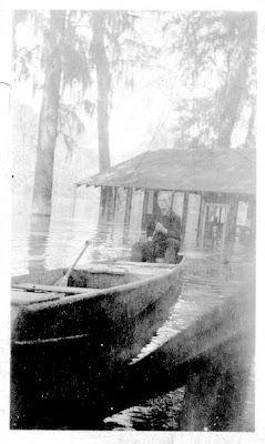
Mr. Emil Menger at Long Lake (northwest of Vicksburg in the flood plain of the Yazoo River).

Mr. Menger’s boat at Long Lake, Mississippi, during the 1927 flood. The gun is still in the family’s collection.

Flooded road in Vicksburg, probably Hwy 61 North (North Washington Street).

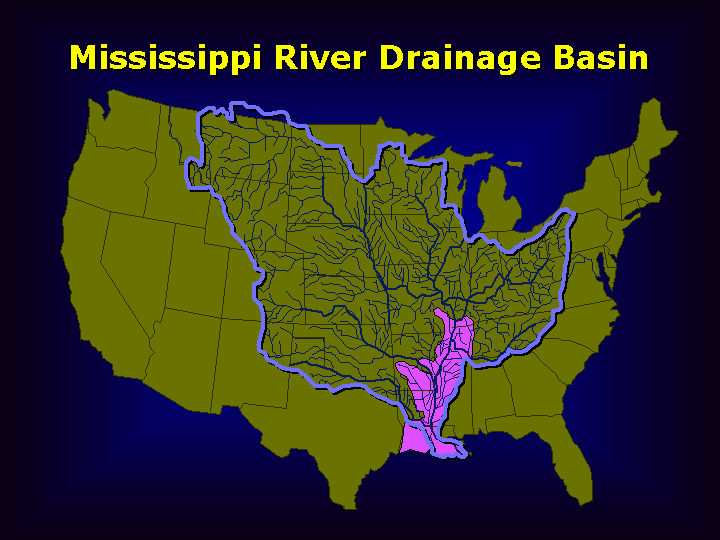
From New Orleans District Corps of Engineers: "The Mississippi River has the third largest drainage basin in the world, exceeded in size only by the watersheds of the Amazon and Congo Rivers. It drains 41 percent of the 48 contiguous states of the United States. The basin covers more than 1,245,000 square miles, includes all or parts of 31 states and two Canadian provinces, and roughly resembles a funnel which has its spout at the Gulf of Mexico. Waters from as far east as New York and as far west as Montana contribute to flows in the lower river."

Mississippi River drainage area with Mississippi River & Tributaries Project area (in pink). From New Orleans District

This map shows the areas flooded in 1927. The map was prepared by the Commission headed by Herbert Hoover. Image courtesy NOAA Central Library and Mr. John Cloud.

The Mississippi Department of Archives and History has a fascinating collection of 1927 photographs on their web page. Highly recommended!

http://mdah.state.ms.us/arrec/digital_archives/1927flood/

For more information on the 2011 flood, please see some of my later blog articles.

Wednesday, May 4, 2011

The Mississippi Delta 3: Red Barn of Rolling Fork, Mississippi


For decades, drivers on Mississippi Hwy 61 drove past a long, handsome red barn south of Rolling Fork, Mississippi. Although long deserted, it stood as a well-known local landmark. On Friday, April 29, 2011, strong winds caused part of the south wall to buckle, pulling down a big piece of the roof. The two photographs below were taken in 2007, but even then, sections of the roof were broken.


According to the Vicksburg Post (1 May, 2011), the barn was built in 1918 by the Graft family. The Department of Defense bought the barn in 2009 or 2010 as part of a 33-acre land purchase. The project was to include an educational center focusing on wildlife and environment, to be called the Holt Collier Interpretative and Education Center. Sadly, the Corps of Engineers did not have authority to do any maintenance or repairs to the barn, and the ravages of rain and time have taken their toll. With recent suspension in non-defense discretionary funding, it is unlikely that any work will be done to restore the barn.

You can see some interior photographs of the wood roof in the Mississippi Preservation blog.

Friday, April 29, 2011

Something is Fishy at the Athens Central Market

This is the first of a series of articles featuring Greece. The Greeks have occupied their rocky, rugged peninsula for four millennia, and they know a bit about decay and rebirth. Athens is the modern capital, a bustling, frenetic city of over four million. The historic heart of Athens is the Acropolis hill, around which there has been human habitation since the Neolithic period. The commercial center of modern Athens is Omonia square, about a kilometer and a half to the north. Connecting the two is Athinas Street, along which you will find tool and hardware shops, banks, bakeries, coffee stalls, bargain clothing emporiums, and the famous Central Market. If you like visiting markets when you travel, this is a great example. It's in a decent part of town, the butchers and vendors are used to tourists, it's colorful and noisy, and it's not too smelly, even in summer. Thousands of tourists wander through, so although any American will stand out, the locals have seen much odder visitors. The market was built in the 1870s. According to a Smithsonian article, the mayor of Athens, Panagis Kyriakos, initiated the project in 1875. Construction continued for ten years, with the arched glass roof finally being completed in 1886. The roof you see in the photograph above is a new one. The market was renovated, painted, cleaned, and "sanitized" about a decade ago. In my files I have photographs of the older, scruffy-looking market, which I will try to scan. I am sure entry into the EU forced the administrators to make changes to comply with EU sanitary standards. This grand hall reminds me of similar 1800s arcades in other cities. In particular, one in Providence, Rhode Island, is said to be America's first enclosed mall. The overall market is in the shape of a large central rectangle with a "U"-shape area surrounding it. The fish vendors occupy the central rectangle, while the meat vendors occupy what was formerly the streets or alleys surrounding the 1870s market building. The streets have been roofed over, so that you think you are in one complicated enclosed building. You can buy almost any sort of seafood here (well, maybe not puffer fish), but all common Mediterranean species. Cod fish and herring come from the North Atlantic, and even a decade ago, I saw boxes labeled "Product of Iceland". Don't forget to pick up some octopus or a squid or two. For fans of Bizarre Foods, Andrew Zimmern visited the Central Market in 2010. This episode aired on May 10, 2011. There are several modest restaurants in the market. I suggest a light meal of grilled sardines, fried potatoes, horta (greens), and crusty, chewy, delicious bread (likely to be better than almost any bread you find in the USA). Wash it down with a beer or glass of retsina (or two or three glasses). Your fellow diners will be a friendly cast of characters. They will be glad to take your picture or pose. You can read more in the market in the Smithsonian article: http://www.smithsonianmag.com/travel/athens-200801.html


Wednesday, April 20, 2011

The Strand Theatre, Vicksburg, Mississippi

Vicksburg once had as many as four downtown theaters (cinemas). Some of my coworkers remember how they saw a show at least weekly, often on Saturday night. One of these was the Saenger Theater at 1203 Walnut Street, whose roof was blown off in the 1953 tornado. A number of children were killed. A dramatic post-storm photograph is at this web page: Saenger
The subject of this post is the Strand Theater, located in the Adolph Rose Building at 717 Clay Street. The Adolph Rose is the handsome gold-colored building in the undated postcard, from the Cooper postcard collection at the Mississippi Department of Archives and History.
The theater operated from 1932-1963 and afterwards housed a Civil War slide and sound show called "The Vanishing Glory." Glory closed about 2005 and the space has been unused since then. The photograph above shows the configuration when Vanishing Glory used it. The screen was mounted in front of a partition that split the original long seating area, leaving an unused area behind. Originally, this would have been an unusually long, skinny venue to show movies.
The prominent local merchant, Adolph Rose, built the handsome Victorian Romanesque building about 1890 for his goods company (Vicksburg Post, 12 June 2011). At that time, it did not contain a theater. Around 1930, it was sold to Feld Furniture, and the ground floor was renovated to house two long thin commercial establishments, a store on the left (now an antique store), and the theater on the right. The seating area extended most of the way from the lobby to the stage at the rear of the building. It must have been a rather odd tunnel-like geometry where the front patrons were practically under the screen and the rear patrons a long way off. The photograph above shows the original stage at the back of the building. This is the area that Vanishing glory closed off and was unused after 1963.
When the theater was retrofitted into the Adolph Rose building, the walls were made of painted press-board. The fitting was skillful, and you can see how the panels curved at the edges of the ceiling. I suppose press-board was selected because it absorbs sound. The sound came from a huge RCA speaker behind the screen. The box is still present, but the speaker units are gone.
The second floor is rather interesting. The little storage room with the racks was for storing film reels. A trap door on the floor opened and a large fan in the wall drew up air though the room and across the reels. Before about 1940, most commercial film was nitrate-based and could spontaneously ignite when it degassed. Theater designers then knew that the film had to be ventilated to reduce the danger of fire. (As an aside, that is why modern photo film has "Safety Film" printed on the edge: it is Ester or Polyester-base and does not ignite spontaneously.) Archivists now store historic movie reels in refrigerated rooms. 
This is the projection booth. It is lined with steel, again to reduce the danger of a fire burning down the rest of the building. The projectors (long gone) were mounted on the floor and projected out small openings to the screen far away. So much heat was generated, the projectors were vented to metal flue pipes that went up to the roof. The earliest projectors may have used carbide lamps. The booth windows were equipped with guillotine-style sliding panels. The panels were held up with steel wires equipped with a lead plug. If a fire broke out, the plug melted and the guillotine door popped down abruptly, cutting off the air supply.
Here are some papers and remains on a shelf in the projection room, including IRS instructions for tax year 1966.
This is the balcony, where "colored" people had to sit in the old days. When I lived in Asia in the 1950s, we white Europeans sat in the balcony.
The lobby area was extensively changed by Vanishing Glory, but a few remnants from the movie era remain.

The good news is that Westside Theatre Foundation, a Vicksburg theater group, is renovating the old Strand and plans to hold live performance there. They have removed the partition wall and will expand the original 1920s stage. Jack Burns generously let me take photographs a few weeks ago. It is an ambitious project and I'm thrilled they have taken it on. They currently hold their productions at the Coral Room in the Vicksburg Hotel, another historic building in Vicksburg that needs its own blog entry.

I took these digital images with with a Sony DSC-R1 digital camera, tripod-mounted.
Update April 2012: Westside is holding stage productions in the Strand and a movie program has begun. The movies are projected from a digital projector, not film as in the old days, but a 16mm projector is available if ever needed. Here is a poster from the famous (infamous?) Reefer Madness.