Sunday, January 10, 2016

Decay within sight of the State Capitol, Jackson, Mississippi

I have always been surprised how a run-down neighborhood can be only a few blocks away from a major commercial or government area. I first encountered this in Houston, where slum houses in the Fourth Ward had a view of the glamorous glass office buildings of downtown. I had not encountered this type of urban disparity in European or New England cities. Jackson fits the pattern: just west of the state capitol, slum neighborhoods are rough and being abandoned or torched.
George Street is (or was) a mess. I have not been back since I took these photographs in 2011, and many of these shotgun shacks have likely been demolished.
East Church Street, a block north of George street, was just as dilapidated. This is a photographer friend checking an abandoned house.
These were once nice residential neighborhoods. Unfortunately, I am not surprised they were allowed to decay. Jackson is in rough shape, and you readers know many of the reasons (I won't list them because this is not a political blog). When the houses are razed, the property no longer serves as a tax source. Less tax revenue means city services, infrastructure, and schools deteriorate, which leads to more people abandoning their properties and moving to more prosperous communities. The blight spirals - the race to the bottom that we see in so many American cities. It is absolutely disgusting.

Photographs taken on Kodak Panatomic-X film with a Fuji GW690II rangefinder camera (the "Texas Leica"). I developed the film in Agfa Rodinal developer at 1:50 dilution and scanned the negatives with a Minolta Dimage Scan Multi medium format scanner.

Friday, January 8, 2016

Lost flood zone houses: Marys Alley, Vicksburg, Misissippi

As of January 2016, another flood is surging down the Mississippi River. The high water, predicted to be about 52 ft above gauge zero on the Vicksburg gauge, will inundate low-lying areas west of North Washington Street. The 2011 flood reached 57.1 ft, a record, but even at only 44.6 ft, the Kings subdivision, located north of the Anderson-Tully Vicksburg sawmill, is subject to some degree of inundation. As a result, residents of homes built on ground level have often needed to evacuate, and the homes were repeatedly damaged. Finally, many of these low houses were purchased and removed via a FEMA program. As of 2012, all the houses along Marys Alley were gone. Click the link to see an aerial photograph from an older post.
These little houses were pretty rough by the time they had been condemned. I guess they were 1940s vintage, semi-shotgun style. They were elevated off the ground a few feet and probably had survived several high water events. But some other houses in this area were 1960s- or 1970s-vintage with slab foundation. A slab house in a flood-prone area?

These are scans of 120-size Kodak Panatomic-X film, exposed with a Fuji GW690II camera with 90mm EBC Fujinon lens. The camera was tripod-mounted. I scanned the negatives with a Minolta Dimage Scan Multi medium format film scanner.

The following list shows historic crest levels at the Vicksburg gauge, from the National Weather Service:

Historic Crests
(1) 57.10 ft on 05/19/2011
(2) 56.20 ft on 05/04/1927
(3) 53.20 ft on 02/21/1937
(4) 52.80 ft on 06/06/1929
(5) 52.50 ft on 04/28/1922
(6) 51.60 ft on 05/13/1973
(7) 51.50 ft on 02/15/1916
(8) 51.00 ft on 04/20/2008
(9) 50.20 ft on 04/16/1897
(10) 49.90 ft on 04/27/1913

And here are some low water records. You can see that the total water level range can be as much as 64 feet.

Low Water Records
(1) -7.00 ft on 02/03/1940
(2) -6.80 ft on 11/01/1939
(3) -5.80 ft on 01/06/1964

Wednesday, January 6, 2016

Lost Small-town Store: Main Street, Vicksburg, Mississippi

For much of the 20th century, many people did not have automobiles, and all towns had local stores to supply staples and groceries. Vicksburg had many of these small stores, but most have disappeared over the years. Williams Gro was at 1620 Main Street. I recall seeing the little shop, but it had been closed for years.
Finally in 2010, the city inspector condemned it along with the house next door. Oddly, both had the address 1620. The spray paint number is the indication that the building has been condemned and that the backhoe will soon crush the hulk.    
Note the Winston sign indicating opening hours and the Holsum bread sign. Holsum had a distributor in Vicksburg years ago.

Technical note: I recently bought an early-2000s Minolta Dimage Scan Multi medium-format scanner. With some manipulation, I got it to work on a Windows 7 computer. I have started testing it with my 6x9 cm 120-size Kodak Panatomic-X negatives, which I expose in a Fujifilm GW690II rangefinder camera (also sometimes known as the "Texas Leica"). This is a big beast of a camera with an astonishing lens. The scans at 2820 dots per inch yield a 100 mb TIFF file. But at that level of detail, I can see lint, flecks of dirt, and non-development spots (probably from bubbles), so it takes some time to retouch the flaws. Dear Readers, in the future, you will see more black and white files from the Texas Leica as I scan my archives.

Friday, January 1, 2016

Decay and loss, Port Gibson, Mississippi

Dear readers, happy and prosperous 2016 to you all!

EL Malvaney writes these great articles in Preservation in Mississippi about preservation efforts around the state as well as the all-too-common failures. The December 31, 2015 article was about 
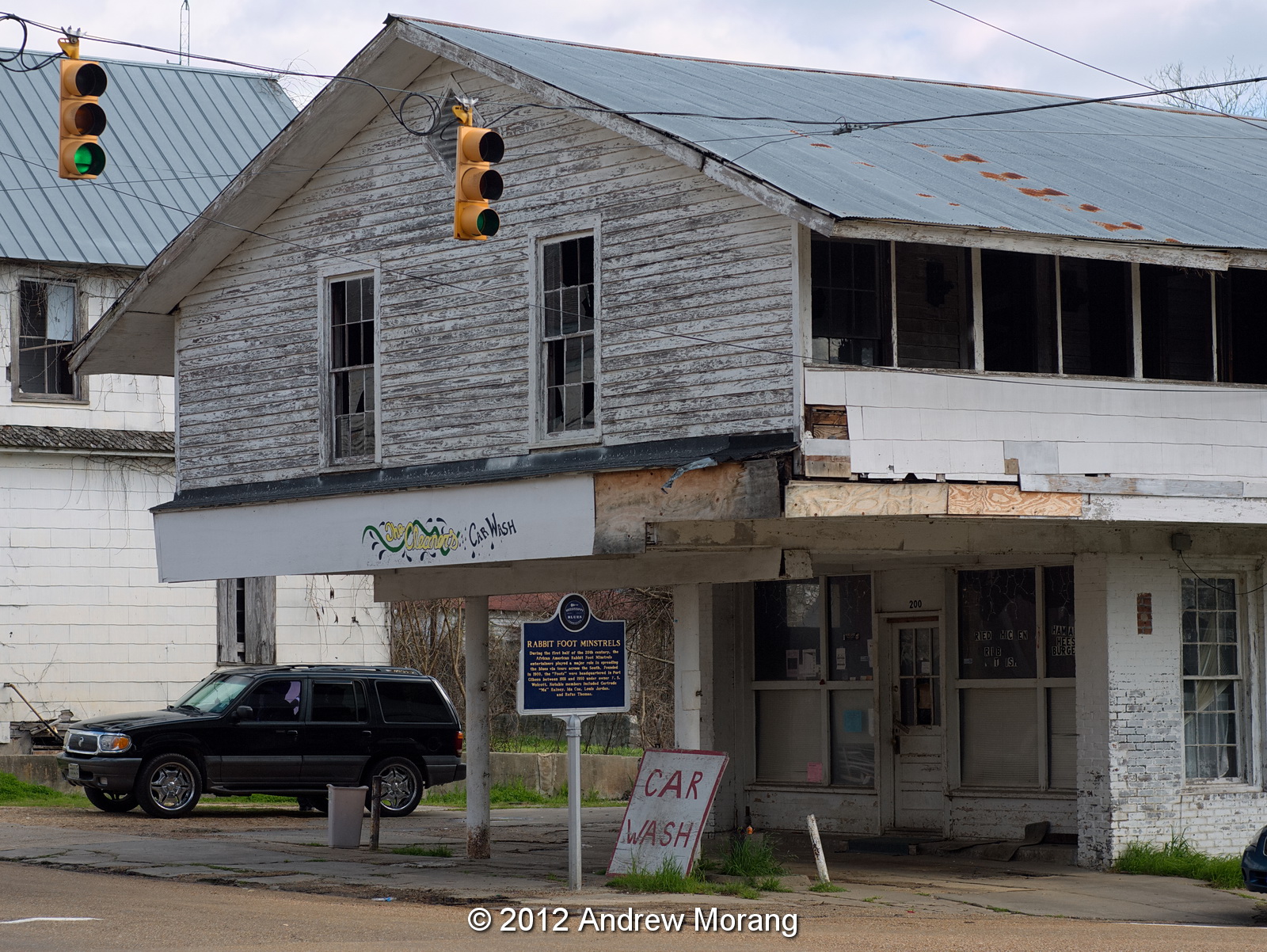
Friends We Lost in 2015. The article mentioned a building in Port Gibson that burned in September. I was out of the country then and totally missed the news. But the article jogged my feeble memory and I found a 2012 photograph in my archives.
This was the former gasoline station at 200 Carroll Street, one of the buildings that burned. I took this photograph from a park across the street with a long lens. Some dudes drove up in a black SUV and waited for awhile. Then other dudes drove by, chatted for awhile, and exchanged packages. Sigh, another example of decay in America.
This is the old Trace Theatre on Main Street. I do not know if it is used.
This was a former grocery store on Carroll Street, also long deserted.
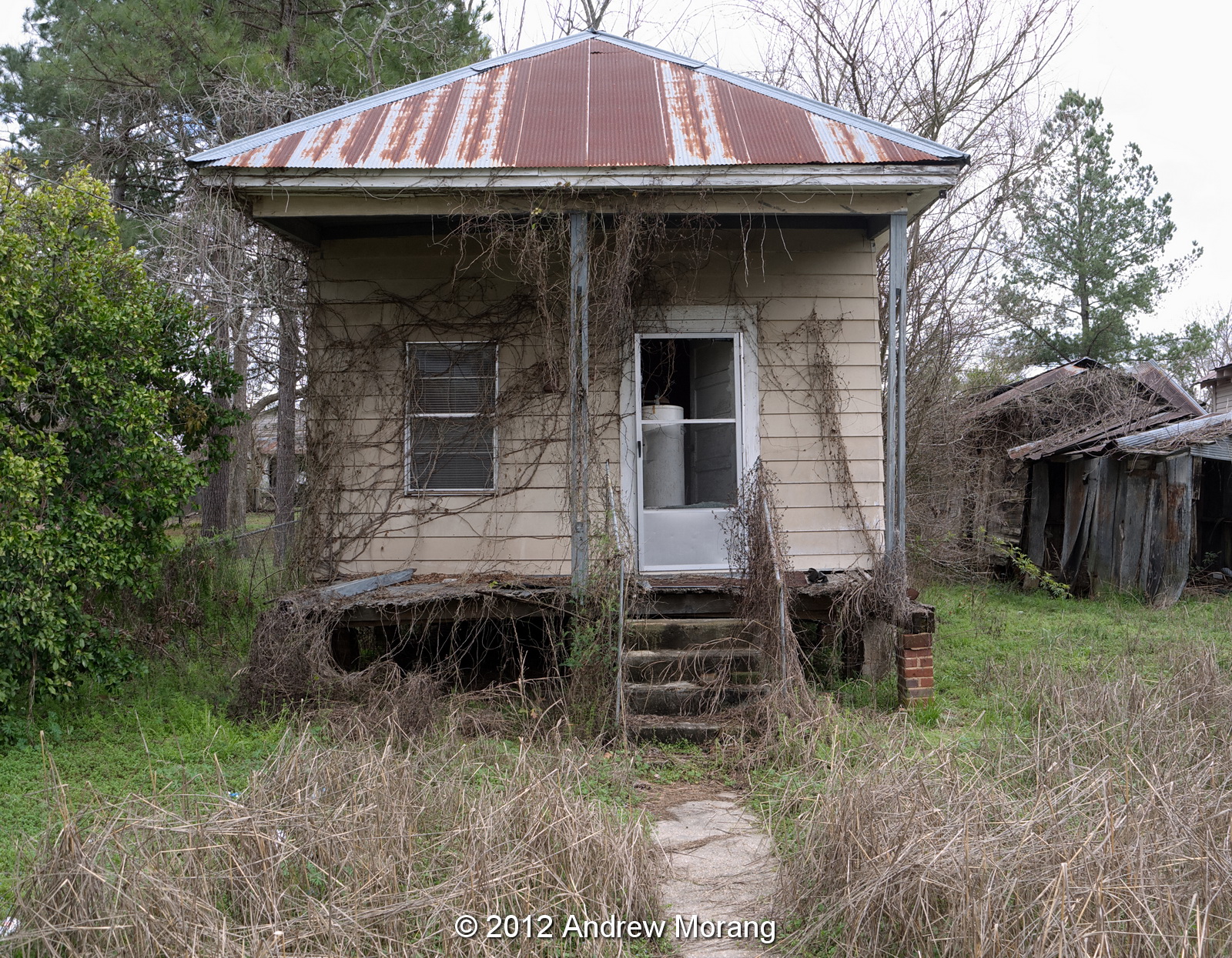
A short distance west of town is Vandeventer Street, with a number of houses that had seen better days a long time ago.
The reason I drove to Port Gibson that cold day in early 2012 was to see the remnants of the cotton seed oil mill on Anthony Street. The brick building in the center of the upper photograph dates to the 1800s.
A work crew was dismantling the machinery in this part of the mill. They said the machinery was being shipped to a factory in Nigeria.
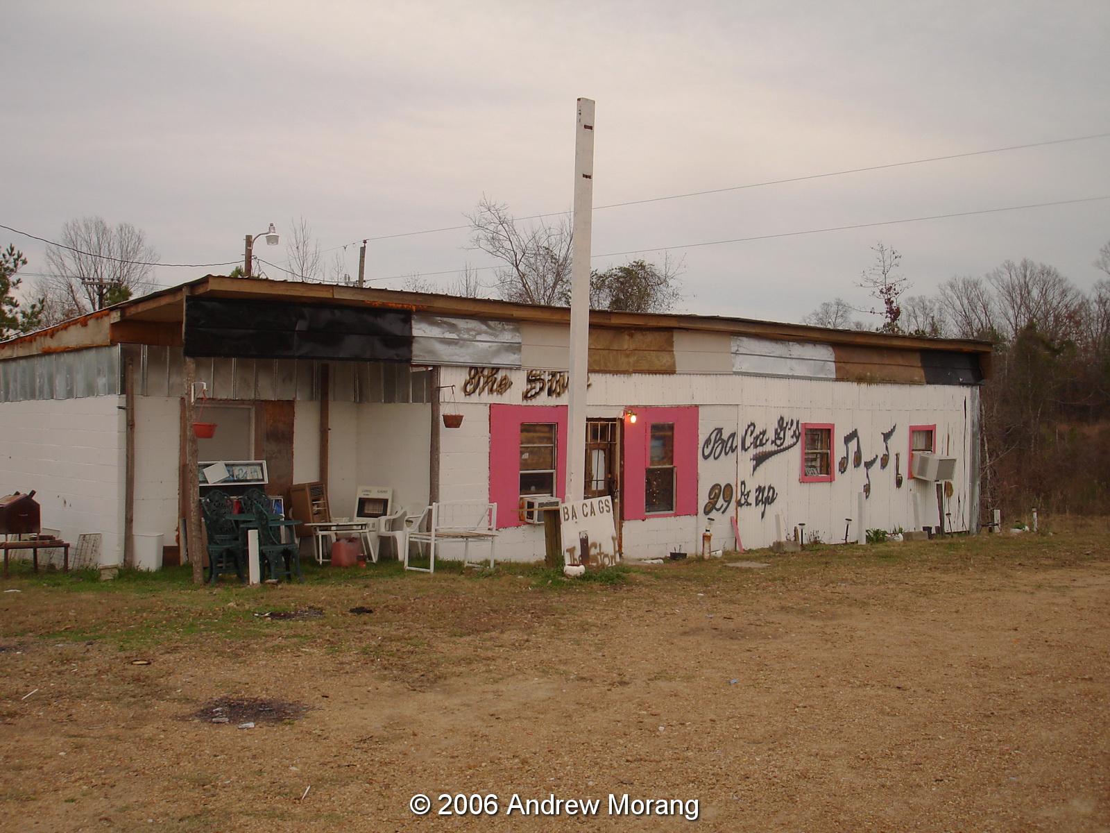
East of Port Gibson on Hwy 18 is (or was) this pink club. The owner said she did not allow any trouble in her place. 

I need to return to Port Gibson before the rest of the town falls down or is dismantled. The 2012 photographs were taken with a Panasonic G1 camera with various lenses. The gas station and brick grocery were with a 50 mm Leica Summicron lens on the G1. Raw files processed in PhotoNinja software.