Thursday, October 8, 2020

On the Erie Canal trail: Lockport and Medina, New York

Lockport


Room with a view, houses overlooking the locks, Lockport, New York (Fuji X-E1 digital file)
Lockport is the county seat of Niagara County in northern New York. It is known for the fascinating locks which lift (or lower) boats and barges on the Erie Canal. According to Wikipedia,
The canal reached Lockport in 1824, but the Flight of Five Locks were not completed until 1825. By 1829, Lockport was an established village. The community was centered on the locks, and consisted mainly of immigrant Scottish and Irish canal workers brought in as labor. The workers remained in Lockport after the completion of the locks, giving the city a heavy Celtic influence still discernible today, especially in the Lowertown and North Lockport neighborhoods.
The city of Lockport was incorporated in 1865.
The Erie Canal was supplanted by the larger New York State Barge Canal in 1918, and the famous south "flight of five" locks was replaced by two much larger locks E34 and E35. The north "flight of five" lock chambers still remains as a spill way.
Lock 35, Lockport, NY, with full capacity
View from gate at Lock 35 looking down to Lock 34


The photograph above is complicated. In the foreground is one of the gates that keeps the water in the pool at Lock 35. Looking down, you see the lower lock then beyond, the Erie Canal.
1839 engraving of Lockport by William Henry Bartlett (1809 – 1854), from Wikipedia 
Erie Canal view upriver towards Locks 34 and 35 (left) and former locks (right)
The bike trail took us steeply downhill past the locks.

One of Lockport's most infamous former residents was Timothy McVeigh, the convicted terrorist responsible for Oklahoma City Bombing.

Medina


Example of Medina Sandstone used in architecture
Main Street, Medina, NY
The Village of Medina is a charming little place where we stayed at the end of our 1st day of biking the Erie Canal tour. The previous night in Buffalo was rather interrupted and unrestful, so Medina looked like it would be a peaceful stopover. The bike group set up tents at the Clifford H. Wise Middle School, which had very nice grounds.

The buildings along the Main Street Historic District consisted of brick or Medina Sandstone commercial structures in excellent repair. Look at the craftsmanship in the arches over the windows.
The side streets, such as Gwinn St. in the photographs above, were lined with early 20th century wood frame houses and cottages. This is small-town Americana at its best. Will our McMansion ghettos age as well as these neighborhoods after a hundred years?
The Medina Railroad Museum is on Gwinn Street. We arrived in town too late to enter the depot, but I read that it contains one of the largest model railroad layouts in the country. That would have been fun.

Dear Readers, this ends my short set of memories of my 2018 Cycle the Erie Canal tour. It was a lot of fun, the other cyclists were very nice, and I lost weight. Maybe try again in 2021? Will we have figured out the virus by then? We can only hope....

Thursday, October 1, 2020

On the Erie Canal Trail: Canajoharie, New York

Canajoharie is a handsome little town south of the Mohawk River in Montgomery County, New York.  It was an important trading area for the Mohawk Peoples before the Revolutionary War. Because the Mohawk and Iroquois allied with the British, the natives were forced to leave after the war, and the State of New York sold land to speculators. According to Wikipedia, the town of Canajoharie suffered major fire three times. As a result, the town passed an ordnance prohibiting wood construction for homes. As a result, many of the handsome older homes in town are brick or locally-quarried stone.
This was Day 6 of the Erie Canal Bicycle Tour, and it had been a long 62 miles from Rome. And the last part of the day included a hill! But Canajoharie was really interesting, and the architecture was classic small-town Americana and photogenic. As usual, the residents were cheerful and welcoming.
Junction of Church, Mohawk, and Montgomery Streets
Elegant stone building, Church and East Main Streets
Mohawk and Church Streets
Brick boarding house(?) or apartments at the junction of Mill and Rock Streets
Church Street historic buildings
I was pleased that most of the handsome 1800s buildings were clean and appeared to be occupied or in use commercially. Nice job.
Handsome cast-iron store front, 47 Church Street, Canajoharie
Millions of storefronts throughout the United States used cast iron as both structural and ornamental elements in their construction in the late-1800s. As documented by the National Park Service,
In the second half of the 19th century, the United States was in an era of tremendous economic and territorial growth. The use of iron in commercial and public buildings spread rapidly, and hundreds of iron-fronted buildings were erected in cities across the country from 1849 to beyond the turn of the century. Outstanding examples of iron-fronts exist in Baltimore, Galveston, Louisville, Milwaukee, New Orleans, Philadelphia, Richmond, Rochester (N.Y.), and especially New York City where the SoHo Cast Iron Historic District alone has 139 iron-fronted buildings. Regrettably, a large proportion of iron-fronts nationwide have been demolished in downtown redevelopment projects, especially since World War II.
Ah, yes, "redevelopment," which in USA often means let the developers pillage and raze older structures so that they and corrupt politicians can make a quick profit, regardless of the damage to social and architectural structures in the community. Quick, tell me how much mall architecture will be valued in the 2100s, let alone in decade. Quick, how many strip malls are worth anything architecturally?

Fortunately there is growing appreciation for cast iron construction and its decorative elements. The National Park Service Technical Brief 11 covers some of the issues in rehabilitation.
A final historical note: this little town played a role in the Revolutionary War. You are always surrounded by history in New York, which added so much to the Erie Canal Tour.

These photographs are from a Moto G5 mobile camera. I used Photoshop Elements 11 to correct converging vertical lines for some of the frames.

Saturday, September 26, 2020

Comfort Food and Ambience at the Franklin Hotel, Rome, New York

For the last 22 years, Parks & Trails of New York (PTNY) has sponsored and organized an annual Cycle the Erie Canal Bike Tour. This is an amazing ride that covers over 400 miles in 8 days. Bicyclists ride along the historic Erie Canal from Buffalo to Albany, camping out along the way and eating at tremendous buffet dinners and breakfasts. The camp sites are at high schools, municipal parks, and, once, at a Jewish Community Center. Riders who do not want to camp can book bed and breakfast inns along the way or stay in indoor gymnasiums.

Unfortunately, the Trump Virus forced the cancellation of the 2020 ride. Instead, PTNY ran a virtual tour with photographs and video from previous years. I hope I can participate again in 2021.

My long-term hiking friend from Albany (see Kilimanjaro) and I biked the Erie Canal tour in 2018. We had excellent weather, although a few days were hot. The tour included over 700 riders from all over the world. One couple from Australia had biked to northern New York from Australia (tough people!).
On Day 5, we cycled from Syracuse to Rome, a distance of about 50 miles. We camped at Fort Stanwix National Monument, a restored fort that played a role in the American Revolution. For dinner, we were on our own, meaning eat in town.

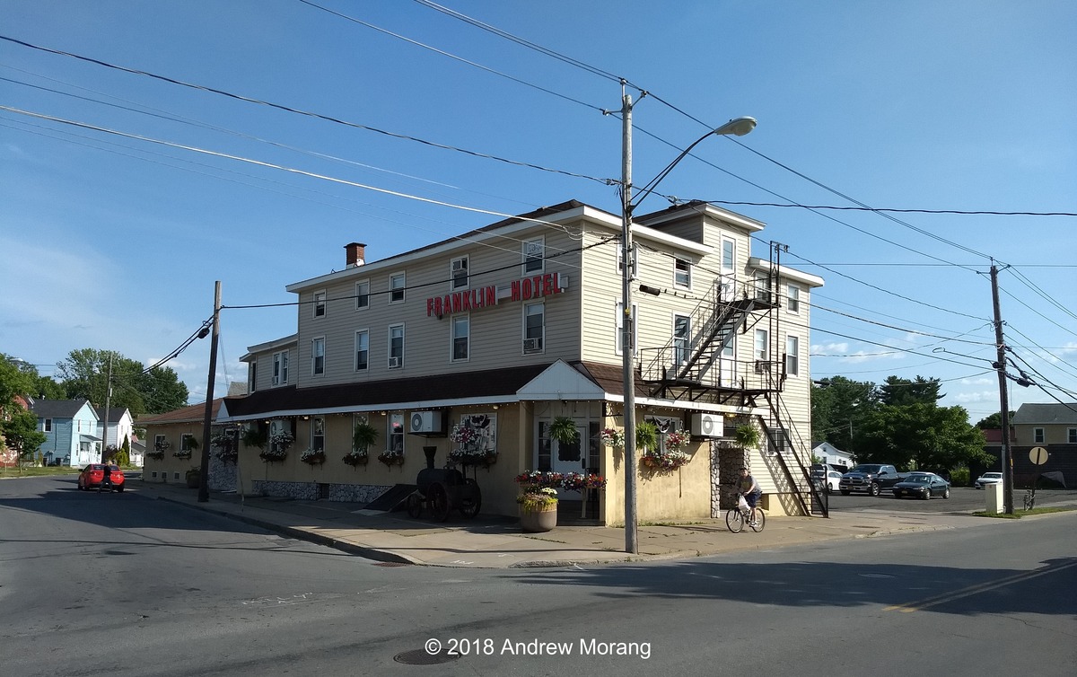
Rome immediately caught my eye. It was a bit tired looking and still had some historic architecture. Some of the other riders recommended that we eat at the Franklin Hotel, at 301 South James Street. The steaks were supposed to be special. Well, after biking 50 miles, a mountain of protein sounded like just the treat. We "deserved" it. (Note: deserved is dangerous vocabulary in Middle America. It is used as justification to purchase any number of material possessions or excess housing, regardless of the real need of said items.)
The steak was excellent, the sides were fresh, and we all feasted as if we deserved it. Most of the customers that evening appeared to be from the bicycle crowd, but the Franklin certainly did not feed 700 people.
Ah, interesting old stairs with sturdy original banisters. But wooden stairs in a hotel? The Franklin's web page describes the food service but does not say anything about rooms, so the upstairs may be closed now.
The upstairs halls were clean but, I think, no longer used.
Rome is an old-line industrial town. Tracks once ran through this warehouse and industrial district. I wish we had been able to explore more, but we were tired and had to sleep in preparation for the next morning's early awakening and vigorous peddling. The Erie Canal Ride passed through some interesting towns, but we did not have enough time to explore. A car trip along this route would be a rewarding alternative some day.

The images are from a Moto G5 mobile phone.

Monday, September 21, 2020

The Mississippi Delta 34: 2012 Road Trip through the Central Delta

Here are some photographs from a short trip through the southern and central Mississippi Delta in March of 2012. I often used digital equipment at this time but still took a film camera with me when I looked for interesting topics.

Boyle


Boyle is in Bolivar County, Mississippi, just a short distance south of Cleveland. Catfish is, or at least was, a big business. I expect most people drive by quickly on US 61/US 278 heading to or from Cleveland, where Delta State University is located. There is not too much to see in Boyle. But south of town, I saw the sun shining on a cluster of old gravestones just off 278. I could not find a name for the graveyard. If any readers can identify the site, please let me know.

Mound Bayou


Mound Bayou, about 10 miles north of Cleveland, has an interesting history in that it was a town founded by former slaves. I wrote about Mound Bayou before in The Mississippi Delta 8 and The Mississippi Delta 8b. The history of this town is a story of determination, back-breaking hard work, and a dream of creating a better life for African Americans in an era when they were treated brutally by the southern white political establishment and the klan.

The Taborian Hospital was founded by the International Order of Twelve Knights and Daughters of Tabor, a fraternal organization. For over twenty years, the hospital provided low-cost health care to African-Americans in the Mississippi Delta in an era when most public hospitals would only admit white patients. When I took these pictures in March 2012, the Taborian Hospital had been closed for almost two decades. From 2012 to 2015, the hospital was renovated, cleaned, and reopened as an urgent care facility. Preservation in Mississippi wrote about the progress in 2012 and 2016. But as of 2018, it was closed again! The facility is mired in some sort of lawsuit, and there is minimal information on the web about what is happening. All that money and effort wasted?

Shelby


Shelby is another town in Bolivar County. It has (had) more of a downtown that many other Delta towns, but today much of Shelby is pretty rough. I wrote about Shelby before in The Mississippi Delta 9. I will return some day and look around some more.

Hushpuckena


Former general store (Panatomic-X, Fuji GW690II, no filter)
Interior of store with discarded medical records (Panasonic G-1 digital file converted to B&W)
Old store in Hushpuchena (Panasonic G-1 digital file converted to B&W)

Hushpuckena is an unincorporated community - really a former town - about 4 miles north of Shelby. A friend's uncle suggested I take a look and he was right. The former commercial strip faced Old 49, which is now a partly overgrown country lane. I included an interior picture from my digital camera because the papers all over the floor were 1980s medical records from Bolivar County Hospital. I told a doctor friend of mine from Greenville, and he recovered and destroyed the records. He said he recognized some nurses on his staff.

This ends our very short 2012 drive through the central Delta. All these photographs except the two digital Hushpuckena files are from Kodak Panatomic-X film taken with my Fuji GW690II camera with EBC Fujinon 90mm Æ’/3.5 lens. I used a tripod to support the camera for all these frames.

Wednesday, September 16, 2020

The Mississippi Delta 33: Crusin' Old 49 to Silver City, Midnight, Louise, and Holly Bluff

Old US 49 passes through rich agricultural terrain in the southern Mississippi Delta. One of my day trips in spring of 2020 was to check some of the small towns along Old US 49W south of Belzoni, see what was happening, and exercise my Tachihara 4×5" field camera. I have written before that I had not used large format film in a number of years, so why not visit towns and record interesting sights in the Delta? In Mississippi, the virus did not force us to remain at home, so visiting the Delta was a nice way to get out of the house.

Silver City


Stir It Up Club, Silver City (Kodak Ektar 25 film, 80mm F/2.8 Planar-CB lens, polarizing filter)
Trading Post, Mims Ave., Silver City (Tri-X, 90mm Æ’/6.8 Angulon lens, 1/50 Æ’/16)

Update June 2022: this little trading post is no longer extant.

Fixer-upper house, Mims Avenue, Silver City (90mm Æ’/6.8 Angulon lens, yellow-green filter)
Club Stir It Up, Silver City (TMax 100 film, Pentax Spotmatic, 55mm Æ’/1.8 Super Takumar lens, polarizer)
Cottage, West Street, Silver City (TMax 100 film, Pentax Spotmatic camera, 55mm Æ’/1.8 Super Takumar lens, polarizer)
Abandoned church, US 49W west of Silver City (Acros film, Leica IIIC, 5cm Æ’/2 Summitar lens, yellow filter)

Silver City is a small town in Humphreys County on US 49W about 7 miles south of Belzoni. I suspect most travelers zip on by heading to or from Belzoni or Yazoo City and barely notice that they drove through Silver City. There is not much to see, just homes, trailers, and a few gas stations. The electronics store looked like it had been shut for years, and I saw some empty houses and a church.

Highway 149 takes you southwest out of town through what seems like endless farm fields with an occasional patch of trees or a bayou.

Midnight


Midnight Gin, Old US 49W (4×5" Tri-X, 180mm Æ’/5.6 Caltar IIN lens, yellow filter) 
Midnight Gin, Old US 49W (GAF Versapan film, 135mm Æ’/4.5 Xenar lens, yellow filter)

Midnight is an unincorporated community at the junction of MS 149 and Old US 49W. The gin just north of town caught my eye because of the shapes and patterns. It provided some opportunities to test some 1960s-vintage GAF Versapan film (see the previous posts on this topic).

Worker cottage, Box Plantation, Silver Creek Road, Midnight (Tri-X film, 90mm Æ’/6.8 Angulon lens, 1/25 Æ’/16)

I saw some nice homes on Silver Creek Road. A handsome 1800s house was being restored. A lady told me that it was once part of Box Plantation. In the back, I saw a workers' cottage with long porch. Most of Midnight is really rough. As quoted in Wikipedia, "Shashank Bengali of McClatchy Newspapers said that Midnight "feels like a place whose time has expired." Bengali explains that the clapboard houses, which were built almost one century before 2010, "rot on their cinder-block legs, tilting at crazy angles" and that Midnight's principal road is "dotted with abandoned or half-burned cabins that, older residents complain, young men disappear into to shoot dice or smoke pot as the days fade into dusk."[4]."

Louise


Main Street, Louise (Moto G5 digital file converted to B&W with DxO filmpack 5)
Main St., Louise (Tri-X, 135mm Æ’/4.5 Schneider Xenar lens, yellow filter, 1/60 Æ’/16.5) 

Louise is another little agricultural town on Old 49W in Humphreys County.

Main St., Louise (Tri-X, 180mm Æ’/5.6 Caltar IIN lens, yellow filter) 
Where is everyone? Main St., Louise in 2016 (Panatomic-X film, Fuji GW690II camera, 90mm Æ’/3.5 lens) 
Lee Hong Grocery, Main St., Louise (135mm Æ’/4.5 Xenar lens, orange filter, 1/200 Æ’/16)

Louise is another small agricultural town with only about 300 citizens. Main Street once paralleled the railroad tracks and had the usual early-1900s square-front commercial buildings and shops. Most are closed now, and some are falling down. The silos dominate the center of town.

Mobile home, Old 49, Louise (Fuji X-E1 digital file)

Much of the housing stock here in the Delta is pretty rough. These unshaded mobile homes in mid-summer must be blazing hot.

Holly Bluff


On this trip, I did not stop in Holly Bluff because I have been there before (please see The Mississippi Delta 17). A couple of miles north of town, an old silo glittered in the setting sun.

Silo north of Holly Bluff (GAF Versapan film, 90mm Æ’/6.8 Angulon lens, yellow filter, 1/25 Æ’/22)

Heading out of Holly Bluff on MS 16 towards Rolling Fork, you pass some rather beat-up trailers and old cottages.

Empty mobile home, MS 16 (Fuji X-E1 digital file converted th B&W)
Asbestos shingle-clad house, MS 16 (Fuji X-E1 digital file converted to B&W)

On this trip, I was able to continue testing some 1960s Versapan film, formerly made by the GAF company. By the time I had photographed the silo just north of Holly Bluff, I had used all my film holders, sunset was close, and Satartia Road was finally above water and open. I headed home. Standby for more of the Delta in future articles.