Showing posts with label Tachihara 4×5. Show all posts

Saturday, November 15, 2025

From the Archives: Vicksburg, Mississippi, in 1990 with 4×5" Film

Vicksburg in the 1990s offered so many interesting photographic topics. It still looked like an "old" town, with small shops, hand-lettered signs, and buildings that stepped out of the early 20th century. It changed and slightly modernized in the decades that followed, so I am eternally grateful that I made the effort to get out and about with my camera way back when. 

Here are some 1990 examples made on 4×5" film, some from my wood Japanese Tachihara camera and others from a Burke & James (an old-time camera manufacturer from Chicago). 


Reverend Dennis with a visitor, 1990 (90mm ƒ/6.8 Wollensak Raptar lens)


Margaret's Gro on North Washington Street was a folk art cultural icon for over 35 years. Reverend Herman D. Dennis married Margaret in 1979 and slowly transformed her store on North Washington Street into his Temple to the Lord. He told me he learned his brick skills from German prisoners of war who he guarded in World War II. Many of his foreign visitors were German tourists. After Margaret and Dennis passed away, the art work deteriorated and vandals stole pieces. The Mississippi Folk Art  Foundation has preserved some of the materials in a warehouse.

Loading dock for logs, Yazoo Canal (Kodak Tri-X film, 75mm ƒ/8 Super-Angulon lens, yellow filter)
Alley behind Washington Street buildings (Turner-Reich Triple Convertible lens at 8½ inch) 

North Washington Street view south (Turner-Reich Triple Convertible lens at 20 inch)

The grassy field in the foreground had railroad tracks under the debris. At one time, passenger trains came to these platforms.

Openwood Street garage (Tri-X film, 75mm ƒ/8 Super Angulon lens) 

Kansas City Southern rail yard and Levee Street, view south to the Fairground Street Bridge (Turner-Reich Triple Convertible lens at 20 inch)

The Kansas City Southern rail yard occupied a flat zone below the Vicksburg bluffs and just east of the Yazoo Canal. A rail yard had been in this area since before the Civil War. Unlike rail yards in big cities, this one had no fences, so one could take interesting pictures. The Fairground Street Bridge in the distance in the photograph above was open when I took the pictures in 1990, but it has been condemned and closed for over two decades. As usual: fate unknown despite its historic status.


Tank farm, Fairground Street (75mm ƒ/8 Super-Angulon lens)

This tank farm was located at the western end of Fairground Street. It was unused for decades. I remember climbing one of the stairs to the top of a tank, and strong petroleum fumes swirled about. I am amazed that there was never a fire. 


Hangar 3 (demolished in 2012) at the Waterways Experiment Station 

The Waterways Experiment Station acquired surplus steel hangars in the late 1940s. Some sheltered  hydraulic physical models of waterways and harbors. Hangar 3 in the photo above came down in 2012. Hangar 4 was demolished to make space for the new headquarters building.  


Steam Laundry (90mm ƒ/6.8 Wollensak Raptar lens)
Waiting for a load (Kodak Tri-X Prof 320, Caltar IIN 180mm ƒ/5.6 lens, 1 sec ƒ/16)

The Vicksburg steam laundry on Grove Street was a fixture of the city in the early 20th century. Some old-timers told me that mid-century, many Vicksburg families never laundered any clothing at home - it all went out commercially. This laundry closed before I moved to town in 1985. 

Before this building was converted into a laundry, it was housed the first industrial-scale Coca Cola Bottling plant. This was not the Biedenharn Coca-Cola Museum on Washington Street. The Vicksburg Foundation for Historic Preservation owns that building and runs the very interesting museum. 

In the 1940s or 1950s, Coca Cola Corporation built a new bottling plant on south Washington Street. An antique store now occupies part of this newer facility. 

In 1992, the Grove Street laundry/bottling plant suffered a catastrophic fire. The rumor at the time is that a developer found asbestos and torched the building rather than renovate it. That is not an unfamiliar story in Vicksburg. I have negatives from immediately after the fire (to scan some day....).

This ends our short 1990 tour of Vicksburg, Mississippi. Thanks for riding along.


Sunday, May 15, 2022

Decaying Rapidly: Oil Mill of Port Gibson, Mississippi

Oil Mill, Anthony Street (4×5" Fuji Astia film, 135mm Schneider Xenar lens and too-small hood)

In late April (2022), a friend and I drove to Port Gibson, in Claiborne County, to look for interesting photo topics. We had both been to the unused oil mill on Anthony Street before and taken pictures there. But this visit, we were both amazed how the brush, poison ivy, and trees have overtaken the site and engulfed machines. Today, you can barely see through the fence, which supports luxuriant poison ivy growth. The jungle is taking over, as per many of the Life after People episodes. Here are some 2012 photographs from when the site was more visible. At that time, the gates were secure and I could not enter.

 Tachihara 4×5" camera, 135mm ƒ/3.5 Schneider Xenar lens, Fuji Astia film
Mill from corner of Anthony and Vanderhaven Streets (Fuji Astia film)

The Mississippi Cotton Oil mill may have been one of the first oil mills in the United States, with the original brick buildings dating to 1882. Preservation in Mississippi discussed the site in a short 2012 article. In the 1800s, cotton seed arrived by railroad. The rail line ran from the town of Grand Gulf to the depot in Port Gibson, but the tracks are now gone. I do not know when mill operations stopped. 

In February of 2012, I read an article in the Vicksburg Post about the mill, inspiring me to drive south to look at the site.


Disassembly of unit on Anthony Street

On that day, a crew of workers were disassembling machines on the north side of Anthony Street (the side nearest to Bayou Pierre. One of them said the machinery would be shipped to an oil company in Nigeria.


This is the view west along Anthony Street

Intact in 2012
Freshly collapsed approx. 2020 (Ilford Pan-F, Hasselblad 501CM, 50mm ƒ/4 Distagon lens, 1/8 ƒ/11.5)

The front part of this building has collapsed. The brick unit to the rear looks like it is still mostly intact.


Vandeventer Street is rough, just horrifying. Many of these shotgun houses have disappeared. 

Port Gibson has some interesting photographic topics:

The digital photographs above are from my Panasonic G1 µ4/3 camera. This was a very capable 12-mpixel camera, which I used in USA, Europe, and Nepal. Standby for some Hasselblad XPan panoramas in the future.

Sunday, April 24, 2022

4×5" Treasure: Kodak Super-XX film (Abandoned Films 09)

Dear readers, I thought my experiments with discontinued films had come to an end when I used a roll of 120-size Gold 100 film in Louisiana in 2021 and then some 35mm Kodak BW400CN in Jackson and North Carolina. Oops, I forgot my box of 4×5" Kodak Super-XX film in the freezer. From Wikipedia:

Kodak's standard high-speed film from 1940 to 1954, when Tri-X was introduced in smaller formats. Discontinued before 1960 in roll-film formats, but sheet film was available until 1992. Originally 100, later 200 iso when safety factor was reduced. Relatively coarse grain. Very long, almost perfectly straight-line characteristic curve, great latitude made it ideal for variable developments, both longer and shorter, water-bath development, special compensating formulas.

Tri-X replaced replaced XX (three Xes rather than two, get it?), although the two overlapped for many years. Many photographers loved Super-XX because of its smooth contrast and subtle grey tones. Kodak still makes a version of Super-XX for cinematography. Some companies repackage it in 35mm cassettes for 35mm photographers, but I have not tried the roll film version.

A treasure of expired film from the freezer

My box had been frozen for decades. It was in the freezer of a dear friend who passed away two years ago.  I had never used Super-XX before and wanted to try it. Here is a small selection of my initial test photographs. 

Neuman Store, Canada Cross Road, Utica (135mm ƒ/5.6 Caltar-S II lens, 1/8 ƒ/32)
Parking lot, Levee Street, Vicksburg (135mm ƒ/5.6 Caltar-S II lens, orange filter, 1/2 ƒ/22)
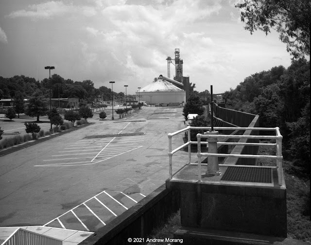
Kansas City Southern rail yard, Vicksburg, 6/7/21 (240mm ƒ/9 G-Claron lens, deep yellow filter, 1/4 ƒ/45)
Porch, 1211 Monroe Street, Vicksburg (90 mm ƒ/6.8 Angulon lens, 1/2 ƒ/22.5)
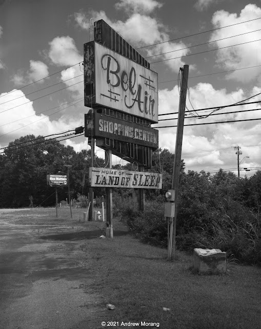
BelAir Plaza, Hwy 80, Jackson (135mm ƒ/5.6 Caltar-S II lens, yellow filter, 1/15 ƒ/22)

These negatives were thin. I exposed them at EI-64 and possibly I need to allow another stop of light (EI=32). It is also possibly that the lab underdeveloped them these frames. I will show more examples in some future articles. Also, I will load film holders and try again as the spring advances.  

Friday, December 24, 2021

Wandering around Lower Clay Street, Vicksburg, Mississippi

Clay Street descending from Cherry Street (Tri-X film (suffering from reticulation) taken from balcony of motel)

Clay Street comes into the core of old Vicksburg from the east. 

When the Methodist minister, Newitt (or Newit) Vick, platted the town, he intended Jackson Street to be the main east-west commercial street and laid it out as two-lane. But commerce did not develop that way and Clay Street became the main road with hotels, shops, and commercial buildings. The National Registry of Historic Places Multiple Property Documentation Form, written by Nancy Bell of the Vicksburg Foundation for Historic Preservation, includes a readable and detailed summary of the city's growth and architectural changes over the decades. The "urban renewal" fad of the 1970s (i.e., free money from the Federal government) led to the demolition of numerous historic buildings and construction of some revolting and largely-unused concrete parking garages. Someone should follow the money and see who really benefitted from these "renewals."

In this short article, I will show you some photographs from lower Clay Street, the area from around Cherry Street and further west, heading towards the Yazoo Diversionary Canal.  

Former Wells & LaHatte appliance company (919 Clay Street), now moved 1 block west (Kodak 4×5" Super-XX film)
Interior of 919 Clay Street (Moto G5 photograph taken through a window)

The Wells and LaHatte company has sold household appliances in Vicksburg since 1935. It is nice to deal with a locally-owned company. They moved from their old building are now one block west at 1301 Monroe Street. 

Former apartments at 915 Clay Street (Super-XX film, 90mm ƒ/6.8 Angulon lens)
915 Clay Street is settling and collapsing (90mm ƒ/6.8 Angulon lens)
Side of 915 Clay Street from Cherry Street
915 Clay Street is an example of the type of multi-floor wood houses that once were more common around town. This one is pretty rough and had been converted into apartments. As of this writing (December 2021), the roof is collapsing into the interior and the house is settling. The photograph of the front door does not have barrel distortion; the house is settling (squashing?) unevenly into the cellar. 

Years ago, an identical wood house occupied the lot to the west, address 911 Clay. In the 1980s and 1990s, Offshore & Coastal Technologies, Inc., had its offices there, but the company closed and the building burned about 10 years ago.

Former Junius Ward YMCA, 821 Clay Street at corner of Monroe (Panatomic-X film, Fuji GW690II camera, 90mm lens)
The Junius Ward YMCA (originally the Young Men's Christian Association) was a center of social and sports activities for decades. The upper two floors contained residence halls for single men. I wrote about the 'Y in 2010 and have posted more interior photographs at other times. The building closed in 2002 when the 'Y moved to a modern facility east of town. No one has been able to reuse the old building, and it sits empty and forlorn. Someone did repair the roof about 10 years ago, but that was the last renovation that I have seen. I read that the building would need modern electrical service, fireproof stairs, and many other serious renovations to make it usable as apartments.

The Old Courthouse Museum sits on a hill in the upper right of the scene.  

Hotel Vicksburg, undated (from the Cooper Postcard Collection, courtesy of the Mississippi Department of Archives and History)
The Hotel Vicksburg at 801 Clay Street opened in 1929 and was the city's sophisticated hotel during the mid-20th century. It was the tallest building in town and even had a radio studio on the roof. Today, it is is the home of the Vicksburg Apartments. I know several people who rented units there and really liked their accommodations. Today, most inns and hotels are generic chain accommodations near the interstate.

Walnut Street view north on a foggy day (Tri-X film, Hasselblad 50mm Distagon lens)
721 Clay Street (4×5" Tri-X negative, 75mm ƒ/8 Super-Angulon lens)

Across the street from The Vicksburg is the elegant 1916 B'nai B'rith Literary Society building, now known as the B.B. Club. In the 1980s and 1990s, this building housed the Vicksburg Police Department. After the police moved to their new building on Veto street, the former mayor, Mr. Lawrence Lyons, bought the BB building and restored it with great care. The police had covered the plaster walls with panelling, but the underlying decorations and plaster work were largely intact. 

Note the sign for The Vanishing Glory. This was a multi-projector slide show held at the Strand Theater. Glory closed in the early 2000s and the Westside Theater Foundation restored and modernized the Strand. I photographed in the Strand in 2011 at the beginning of its restoration. 

The Strand Theater is in the Adolph Rose Building, circa 1890 (717 Clay Street). This is one of the best of the remaining late-1800s commercial buildings in Vicksburg, demonstrating the City's commercial and cultural prosperity in that era. It is on the National Register of Historic Places. I photographed in the Alolph Rose Antiques gallery and will post some pictures soon (stand-by for artsy photographs).

Clay Street view west to Yazoo Diversionary Canal and flood walls

Go west a block to Washington Street, and Clay Street becomes much steeper as it descends to the flood walls and the Yazoo Diversionary Canal. In the 1800, this was the main channel of the Mississippi River. Steamboats tied up along this waterfront, but now the view is marred by the concrete walls. 


A passageway, paralleling Gordon Lane (or alley), runs north through a tunnel in one of the old brick buildings. The tunnel is sort-of picturesque. No, it's just plain ugly. The rear facades of the buildings are sort-of picturesque. No, they are just plain ugly.


All right, the dead boat in one of the lots behind some Washington Street buildings is picturesque.

This ends out short tour of lower Clay Street and vicinity. Standby for more of Vicksburg in the future.

Merry Christmas and Happy Holidays to all of you readers. Thanks for riding along.

UPDATE:  I found a digital color photograph of the old warehouses on the north side of Clay Street. What would one find in one of these boarded-up buildings?

Lower Clay Street (Fuji X-E1 digital file, 1962 Jupiter-8 lens, ƒ/5.6) 


Thursday, December 16, 2021

Wandering around Upper Clay Street, Vicksburg, Mississippi

Clay Street view west (Panatomic-X film, Hasselblad 250mm Sonnar lens, 1/15 ƒ/8.0½)

Clay Street is the major east-west road through Vicksburg. Before Interstate 20 (I-20) was completed in the early 1970s, US 80 came into town on Clay Street. A driver heading west would drive on Clay to downtown, turn left on Washington Street, and drive south to the old Mississippi River bridge.

I label the part of Clay Street just west of the Vicksburg National Military Park as upper Clay, while the area downtown near the Yazoo Canal is lower Clay. Here we will look at some scenes in upper Clay. Decades ago, private homes lined the street, but now it is strip America of the ugliest sort. You car, tire, and muffler repair shops, check-cashing and title-loan places, a few real estate offices, abandoned buildings, a dead A&P super market, derelict historic homes, and fast food emporiums. Empty lots show where houses once stood. A former resident labeled this "the ugliest street in America." Well, maybe not the ugliest, but certainly a contender. 


The Eastview Apartments, situated between Clay Street and Baldwin Ferry Road, are low income housing subsidized by the federal government via HUD (Housing and Urban Development). They are unusual construction, being suspended between telephone poles that were driven into the ground on the steep hillside. It was a practical solution compared to grading flat terraces and pouring concrete slabs. 

Eastview Apartments with Stouts Bayou in foreground (Panatomic-X film, Hasselblad, 50mm ƒ/4 Distagon lens, green filter)

Stouts Bayou flows under Clay Street through some form of culvert or tunnel because it emerges out of the hillside below the Eastview Apartments. This is kudzu jungle. It needs a cleanup by goats.


Warfield's ServiceCenter, at 2910½ Clay Street, has served customers for over 30 years. Good people.
 

One of the nondescript street running into Clay Street from the north is Hope Street. The proprietor at A & V Discount Tobacco & Beer generously let me take a photograph.


The long-unused Parkview Regional Medical Center building looms over the area north of Clay Street. It has been vacant since 2002, except for homeless who occasionally find ways to enter.

Mercy Hospital, Grove St. (Kodak Super-XX film, Tachihara 4×5" camera, 90mm ƒ/6.8 Angulon lens)

The Sisters of Mercy, who have a long history of care in this town, originally built Mercy Hospital in 1957. The present owners have tried to sell it but with no results. Who wants an obsolete hospital building considering the cost to renovate and upgrade electricity, exits, stairwells, and utilities? Externally, it looks intact, but I do not have information on the roof or the interior. 

When I took photographs in the parking lot in the rear, the neighbors came by and said they watch for vagrants. The police come, clear away the homeless, and then they return later.


Further west is a short segment of Crawford Street. This is not the main Crawford Street downtown but a short detached section running directly next to Stouts Bayou. The houses are on the south side of the road and have access via wood bridges. I photographed more of the Crawford Street region during my tour of neglected Vicksburg houses (Nov. 16, 2020 article).

1517 Main Street (Panatomic-X film, Hasselblad 501CM camera, 80mm lens, 1/8 sec. ƒ/8.0½)

Main Street is one of Vicksburg's historic streets. It is still lined with old houses, but one by one, they have been condemned and demolished. This house at 1517 looks pretty good, and I do not know its issues.

This ends our short tour of upper Clay Street. Standby for more Vicksburg photographs soon. Thank you all for riding along.