Tuesday, August 16, 2022

The Wide View in Vicksburg in Color (XPan 06)

Kodak Portra 160 film

I had three rolls of Kodak Portra 160 film in the freezer. It was expired but had been cold stored since 2013. I thought it would be useful to try a color film in the Hasselblad XPan because of the ability to place a colorful central object as the focal point of a panoramic frame. Below are examples from semi-random trips in and around Vicksburg. Please click any frame to see details at 2400 pixels wide. All comments welcome.

Good stuff, Mt. Alban Road (30mm ƒ/5.6 lens)

Oh, no, it's the car junk yard on Mount Alban Road that I periodically impose on you. I liked the red truck this time. And the extra wide coverage shows the unending supply of tires and junk. 

Former Mercy Hospital, McCauley Drive (30mm lens)
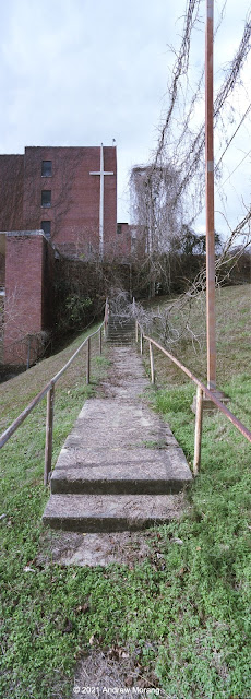
Mercy Hospital (30mm vertical)

The Vicksburg Sisters of Mercy opened Our Lady of Mercy Hospital in 1957. At that time, it was a state-of-the art medical facility for the post-war era. In the 1950s, this was the "white" hospital. African-Americans used Kuhn Memorial (Charity) Hospital a short distance away. 

Later known as Parkview Hospital, Mercy closed permanently in February of 2002. A 2012 article in Preservation in Mississippi includs dozens of comments from former patients and employees. The building suffers from black mold, asbestos, leaks, vandalism, and myriad other issues. It will never be used again.

Mississippi still suffers from great disparities in health care and ranks last in almost every health outcome among US states.* White politicians in Jackson refusing to extend Medicaid and underfunding public health have perpetuated this disparity.

New Year clean-up, Candee Street. Where is Italy? (45mm lens)
More New Year clean-up (45mm lens).

Just after New Years is a good time to clean out furniture, toys, and posters showing maps of Italy. Good stuff.

View west from Drummond Street near Bowmar Avenue (45mm lens)
Bridge over Stouts Bayou at Letitia Street (45mm)
Asam Hotel, Washington Street (45mm lens at ƒ/11, tripod-mounted)

This and other motels once provided a view over the Mississippi River. Most became low-end temporary housing over the years. A new operator has bought or leased this unit and recently painted it. It was formerly the Dixiana Inn.
 
Sycamore Avenue, view south (45mm lens at ƒ/11)
Free furniture, Sycamore Avenue (30mm lens at ƒ/11)

Sycamore Avenue is one of Vicksburg's semi-hidden streets, seldom used and with only one house left on the hillside. When house lots were originally platted, innovative builders stuck houses on stilts just about anywhere where they could fit them. Over the decades many have burned, collapsed, or been torn down. I wonder when the City will abandon Sycamore Avenue? I cannot tell if it serves any purpose now.

Thank you for reading. We will see south Vicksburg next time.


  Mississippi ranks last, or close to last, in almost every leading health outcome. In Mississippi and nationwide, these health disparities are significantly worse for those who have systematically faced obstacles to health due to their socio-economic status, race, ethnicity, religion, sexual orientation, geographic location, and other characteristics historically linked to discrimination or exclusion.

The result is a disproportionate burden of disease and illness that is borne by racial and ethnic minority populations and the rural and urban poor. Health disparities not only affect the groups facing health inequities, but limit overall improvements in quality of care, the health status for the broader population, and results in unnecessary costs.


Monday, August 8, 2022

The Wide View in Vicksburg, Dec. 2021 (Hasselblad XPan 05)

Corner of Monroe and China Streets, Vicksburg, MS (30mm ƒ/5.6 lens, center filter, ƒ/8.0½)

Corner of Monroe and China Streets, Vicksburg, MS (30mm ƒ/5.6 lens, center filter, ƒ/8.0½)

When my friend first loaned me his gorgeous XPan panoramic camera, I took sample photographs around Vicksburg with Kodak Tri-X 400 film. 

Over the years, the standard 45mm lens was the most common one for XPan photographers. This was already pretty wide on this format. My friend also has the amazing 30mm ƒ/5.6 lens, which has proven to be a challenge. You need textures or interesting features in the lower foreground to keep the scene from being too boring. I think the first example above is effective, but the second photograph may have too much plain foreground. Click any picture to see it at 2400 pixels wide, and all comments welcome.

Good stuff junk yard, Mt. Albans Road, Vicksburg (30mm ƒ/5.6 lens)

This is the car junk yard on Mt. Albans Road east of Vicksburg. Readers may remember older pictures from here. 

Corner store, Mt. Albans Road (45mm ƒ/4 lens, Fuji Acros film)
Gorilla pawn shop, Washington Street, Vicksburg (45mm lens, med. yellow filter) 

The 45mm ƒ/4 lens has amazing resolution across the frame.  

Cherry Street at Clay, 30mm ƒ/5.6 lens, yellow filter, ƒ/11 (Fuji Acros film)

This little store at the corner of Cherry and Clay Streets housed the Wells & LaHatte appliance business for many decades. The business has moved one block away and the little wood building is for sale. The extra wide 30mm ƒ/5.6 lens is an amazing optic, but I found it works best when stopped down to ƒ/11.

Mt. Heroden Baptist Church, 1117-1119 Clay Street (30mm ƒ/5.6 lens, yellow filter)

Standby for more panoramic scenes in Vicksburg and the surrounding area. Thank you for exploring with me.

Sunday, July 31, 2022

Panoramas on the Dixie Overland Highway - Mound, Tallulah, and Delhi (XPan 04)

As I wrote in the previous article, a generous friend loaned me his fabulous Hasselblad XPan panoramic camera. You may recall that I wrote about using an XPan in western Washington and Seattle during 2004, when I worked there for a few months. 

This offer was much too kind to resist. Loading a roll of Kodak Tri-X 400 film, I crossed the Mississippi River bridge to Louisiana and drove west on historic US 80, once known as the Dixie Overland Highway. I have photographed in Mound and Tallulah before with regular cameras, but the area offers topics for a wide view. Please click any picture to enlarge it. Unenlarged, they look like skinny sideways pictures, especially on a mobile phone.  (An aside: one day I plan to follow the former route of the Dixie Overland all the way to San Diego.)

Delta


Mount Zion BC Church, near Delta, Louisiana (45mm lens, med. yellow filter)

Tallulah


Tallulah is a bit beat-up. I have photographed there over the years and sometimes bicycle through town if I bike the loop on LA 602 and US 80. 

No shopping here, West Green Street (US 80), Tallulah (45mm, med. yellow filter)
No shopping here, either, West Green Street
Waiting for a load, West Green at Fourth Street (45mm at ƒ/8, yellow filter)
Fixer-upper house west of Tallulah, US 80
Willow Bayou Rice & Grain, west of Tallulah, US 80

Delhi


Delhi (Del'-high) is an agricultural town west of Tallulah on US 80 (no, not the Delhi in India - I have been there, too). It looks a bit more prosperous than Tallulah, and the downtown strip has some stores and restaurants.

Mooney's Auto Sales & Repairs, First Street (US 80) at Rundell Street, Delhi
No more pumping, Delhi Water Works
The Air Man of Delhi, First Street (US 80)

I took these photographs on Kodak Tri-X 400 film exposed at EI=320. Northeast Photographic in Bath, Maine, developed the film. Because the frames are 68mm wide, I scanned them in two pieces of 36mm with my Plustek 7600i film scanner and merged them with the Photomerge function in Photoshop CS5. The Tri-X is a bit grainy and does not let these lenses show their true potential.

Thanks, Bill, for letting me use your XPan!

Standby for more Xpan photographs in the future, including examples in color.

Sunday, July 24, 2022

Hasselblad XPan Panoramic Camera: How to Handle the Film? (XPan 03)

Hasselblad XPan camera with 30mm, 45mm, and 90mm lenses
XPan with 30mm ƒ/5.6 lens and special viewfinder
Center filter on 30mm ƒ/5.6 lens


The amazing hardware


A friend in town generously loaned me his fabulous Hasselblad XPan camera with its three unique lenses. The Hasselblad XPan (and the identical Fuji TX-1) were innovative cameras that used regular 35mm film to create a negative that was 24×65 mm in size rather than the usual 24×36 mm frame common in most 35mm cameras. 

For me, the wide frame was a revelation. Through the viewfinder, I could see topics that I might have skipped with a normal camera or would have found boring without the wide frame to show the context of the scene. The wide frame provides a narrative to the main topic. I will post a series of XPan articles in the next few months. 

A recent guest author on Casual Photophile also wrote about how the wide view gave him a new way of viewing his world. An author on 35MMC found his XPan to be his favorite travel camera. But Hamish Gill of 35MMC found that the XPan just did not suit his type of photography enough to keep the valuable camera. It is a specialist tool to be sure.

However, this camera's wide frames require different handling than normal 35mm negatives. I did not see much on the internet about how people process or scan this unusual 24×65 mm frame. This article will describe my procedure.*


XPan negatives (converted to positive). Oh, oh, what to do with the odd shape?

Optical enlarging


If you print in a darkroom optically, any medium format or 4×5" enlarger like a Beseler would be suitable for the XPan negatives. I was surprised to see that Beseler still sells an XPan film holder. It is rather expensive at B&H, but at least is available. 

Years ago, some commercial labs developed XPan negatives and printed 4×12 inch machine prints. Nice. I have some albums with pages just for this size.


4×12 inch prints in plastic album. Lake Union, Seattle, Washington

Some companies made plastic print booklets specifically for the 4×12 prints.

Scanning options


Most people today probably scan the negatives and then post the results on the web or make ink jet prints. But how to scan these odd-size negatives? Some options:

  1. Use a digital camera with macro lens and a copy stand to take a picture of the negative, and then reverse with software. My friend who owns the XPan uses this technique. 
  2. Scan the negatives on a medium format scanner. My Minolta Scan Multi will fit the 65mm length, but I would need to cut a 24×65 mm mask. Minolta may have once sold a frame and mask in this size, but I doubt I could ever find one. Nikon's medium format scanners could be used for Xpan negatives. They used to sell a glass negative carrier that came with a mask for the Xpan format. It worked but was clumsy and very slow. 
  3. Scan left and right frames of 24×36 mm in a regular 35mm film scanner and then combine them with software. I used this method with my Plustek 7600i scanner and then merge the two pieces with Photoshop CS6 (details below). 
  4. Commercial scanning. Some laboratories may offer this service via the Imacon Flextight scanner (alas, no longer available new and staggeringly expensive)

Digital camera scanning


Monument Valley Navajo Tribal Park, Arizona. © Bill Stripling
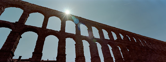
Acueducto de Segovia, Segovia, Spain. © Bill Stripling
French Pyrenees. © Bill Stripling

This is Method 1 above. These are all scans made with a Nikon Z7 camera and reversed in Lightroom with Negative Lab Pro software. To my eye, these results look fantastic. If you have a high-resolution digital camera, this is an excellent technique. The quality of the light source is important if you are scanning color negatives. For LED sources, the spectrum needs to be as smooth as possible. Gaps or spikes in the spectrum can cause color shifts. 

Merging 24×36 mm scans


Plustek 7600i scanner with 35mm negative holder. Note how one XPan frame overlaps into the second opening.

I use Method 3, where I scan left and right sections of the XPan negative sequentially. For the two frames to blend properly, there must be some overlap (possibly 10-20%). You need to set the exposure and color balance for one of the frames and then be sure to not change those settings for the second frame. What I do:
  1. Preview the left or right section in a 24×36 mm frame (i.e., the full size for this scanner).
  2. Adjust color, gain, and contrast as needed.
  3. Make a final scan at 3600 dpi and save as a 16-bit (full color) TIFF file.
  4. Remove the film holder, pull the XPan frame so that the other side is in the 24×36 opening.
  5. Reinsert the holder in the scanner but leave gain and color unchanged. This means I cannot preview this second piece.
  6. Make a final TIFF scan of this second section.
  7. If needed, clean scratches and chemical blobs with the heal tool in Photoshop.

Assembly


It sounds confusing but is relatively simple. Then I use the >Automate>Photomerge tool in Photoshop CS5 or CS6 to combine the two sections. Make a final check if the wide frame needs some cropping and you are done. It is a bit time-consuming but works well. 

Below is an example from the rail line south of the Amtrak Station in Jackson, Mississippi and one from a junk yard in Edwards.


Pascagoula Street overpass left frame


Pascagoula Street overpass right frame


Final panorama from Pascagoula Street overpass (Kodak Portra 160 film)

I-20 junk yard left frame


Junk yard right frame


Final panorama, I-20 North Frontage Road, Edwards (Portra 160 film, 45mm ƒ/4 lens at ƒ/5.6½)

Despite the work, this Xpan is a lot of fun and an amazing creative tool. Standby for more examples. Thank you, Bill, for letting me use your camera.


* I am not going to use the term "workflow." That is a cliche on photography web pages, especially the infamous DPreview. "I returned from my weekend in Paris and did my special workflow to my 15,000 shots." Bleech.


Sunday, July 17, 2022

Back When it was Cool: Charles River, Boston, January 1968

Winter of 1968


With the summer midday heat here in Vicksburg hovering around 34° or 35° C (95° F), one thinks of cool. In my stuff (of which there is far too much), I found some Kodachrome slides of the frozen Charles River in Boston. I took these in January of 1968, when I did not know anything about photography but was excited by views and vistas. My grandmother was visiting (the lady from my Escape from Berlin article), and we went to the Top of the Hub observation deck in the Prudential Tower. I can't recall if we ate lunch up there. 

Charles River view west with Cambridge across the river
Charles River view northeast towards Charlestown with Longfellow Bridge in the center

The handsome multi-arch bridge is the Longfellow Bridge, built in 1901. A friend remembered how badly rusted the steelwork had become some 20 years ago. The structure received an almost total rebuild in the early 2000s. Beyond the Longfellow bridge is the Charles River Dam, on which is located Boston's Museum of Science.

Back Bay in foreground with the Charles Basin and MIT campus across the river

Decades ago, I taught sailing in the Charles Basin at Community Boating. This public sailing organization has run programs for adults and children here since 1946. Summer was lazy and laid-back. We filled baggies with water and threw them at other boats. During those sailing days, I sometimes walked across town to Durgin Park Restaurant for a cup of chow-dah and a 95 cent luncheon. Then home via the MBTA on Dime-Time (yes, only 10 cents).

In autumn, the winds picked up and the fun increased. If a boat went over, a motor boat came out to pick us up and right the capsized sail boat. Then they took us to a doctor in Back Bay who administered tetanus shots. There was none of that get permission from your parents stuff - you got a tetanus shot. How times have changed. 

But best of all, the Charles River has been drastically cleaned. Once a national scandal for its pollution, the river now hosts fish, eagles and other wildlife. This is a dramatic example of the benefits of federal waterway protections by means of the EPA's Charles River Initiative.

Topographic Notes


Let us step back into topographic history. Much of the flat land area today in Boston is artificial land fill. We often use the term "reclamation," as if we are reclaiming the land from the sea or river, waging battle on the evil forces of nature. 


Landfilling in Boston since 1630 has more than doubled the urban area (unfortunately, at the expense of destroying what must have been highly productive wetlands). The figure above is adapted from Rosen, Brenninkmeyer, and Maybury (1993).

The Charles River Basin and the neighborhood that you see in the snowy pictures above is artificial. The tidal river between Boston and Cambridge was formerly an expanse of mudflats which were exposed twice daily and renowned for mosquitoes and nasty aromas in summer. The original 1910 dam converted the basin into an agreeable fresh-water body, along which fashionable homes, a landscaped esplanade, and institutions of higher learning were located (Whitehill 1968). 


Museum of Science on original Charles River Dam

Little of the original dam can be seen because a busy highway crosses it and the Museum of Science was built on the dam in 1950. 

New Charles River Dam and pump house, completed in 1978

The new Charles River Dam is multi-function project. Not only was it designed to protect against unusually high tide or surge in Boston Harbor moving upstream into the basin but also to maintain a restricted range of water level in the Charles River Basin. Large pumps can pump rainwater and runoff from the river side of the dam out into the harbor side (on the left in the photograph). The pumps first operated during the Northeast Blizzard of '78. 

Back Bay in 1944, before construction of the Prudential Tower

The Back Bay has been Boston's most fashionable neighborhood since the marsh ands tidal flats along the original Charles River were drained and filled, with construction starting in 1859. From Wikipedia:
Setback requirements and other restrictions, written into the lot deeds of the newly filled Back Bay, produced harmonious rows of dignified three- and four-story residential brownstones (though most along Newbury Street are now in commercial use). The Back Bay is listed on the National Register of Historic Places, and is considered one of the best-preserved examples of 19th-century urban architecture in the United States. In 1966, the Massachusetts Legislature, "to safeguard the heritage of the city of Boston by preventing the despoliation" of the Back Bay, created the Back Bay Architectural District to regulate exterior changes to Back Bay buildings.
My wife's mother and parents lived in the Back Bay before World War II, but I do not know the address. If you worked in downtown Boston, this would be elegant and convenient.

Visit Boston, walk in the Back Bay, admire the fashionable and expensive stores, lunch at a bistro, have your hair done at a spa, and consider how history surrounds you.

References

Rosen, P. S., Brenninkmeyer, B. M., and Maybury, L. M. 1993. “Holocene Evolution of Boston Inner Harbor, Massachusetts,” Journal of Coastal Research, Vol 9, No. 2, pp 363-377.

Whitehill, W.M.  1968.  Boston, A Topographical History.  Second edition, enlarged, Belknap Press of Harvard University Press, Cambridge, MA, 299 p.


The snow pictures are from Kodachrome II film, probably taken with my dad's Canon rangefinder camera (unknown model) and its 50mm ƒ/1.9 Canon Serenar lens. My dad's 1944 Kodachrome is from a Perfex camera (unknown model).