Showing posts with label farm buildings. Show all posts

Sunday, March 27, 2022

The Football Scenic Road, central North Carolina (Abandoned films 08c)

North  Carolina Scenic Byways (from NC Department of Transportation)

Introduction


The State of North Carolina has a network of scenic byways that cover many of the historic and scenic parts of the state. If you go to the Department of Transport web page, you can download a book of the byways and look at an interactive map. You can also request a printed copy of the book.

The screen capture above is the online map on the NC-DOT web page. The blue line in the west is the Blue Ridge Parkway. Long-term readers may remember that I have driven much of the Parkway in 2017 and 2018. I have also driven the Nantahala and Fontana (Rte. 28) Byways. It is beautiful terrain in the west. 

For the urban decay photographer, the state is a treasure trove of old farmhouses, mills, factories, and quiet little towns that look like time passed by. 

The Football Road (west of Chapel Hill)


The DOT calls the route between Chapel Hill and the outskirts of Greensboro the Football Road. I do not know why it has this name. But it goes through nice farm country and avoids the boring Interstate 40. Part of it is Old Greensboro Road and then becomes the Old Greensboro-Chapel Hill Road.

Barn on Old Greensboro Road, near Chapel Hill
Farm house, Dawson Road near Chapel Hill
Farm, Old Greensboro Road near Chapel Hill
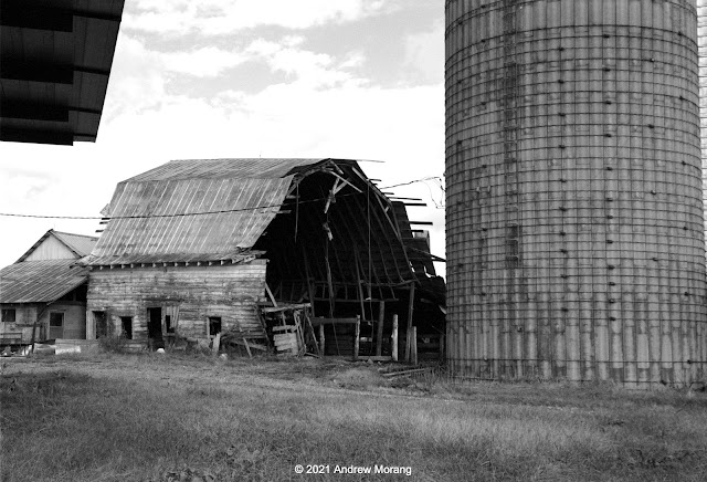
Barn, Greensboro-Chapel Hill Road near Snow Camp
Farm, Greensboro-Chapel Hill Road near Snow Camp (Jupiter-8 lens, yellow filter)
Happy cows, Greensboro-Chapel Hill Road near Eli Whitney

The Greensboro-Chapel Hill Road winds its way past farms and woods. An occasional car or tractor passes by. I was surprised that many of the silos consist of concrete tubes reinforced with exterior steel bands. It is a cylindrical version of a barrel. 

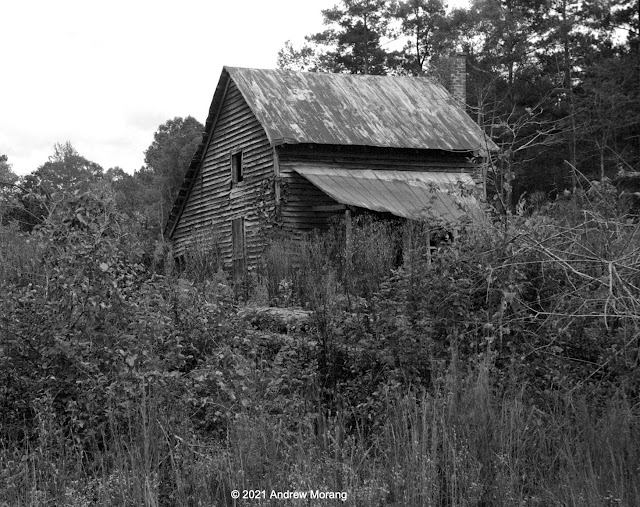
Fixer-upper house, Greensboro-Chapel Hill Road, near Snow Camp

Snow Camp


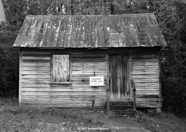
Historic school, Snow Camp Outdoor Theatre, Snow Camp
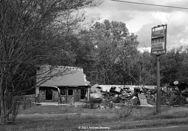
Restaurant next to Snow Camp Outdoor Theatre

The Snow Camp Outdoor Theatre is at 301 Drama Rd. (great name!) in Snow Camp. The site was empty when I visited in October, but in-season, the semi-professional company has been presenting plays for over 40 years. The restaurant next door will not be providing any meals for a long time..... 

Unoccupied farm, Holman Mill Road, Snow Camp

This ends our short excursion on the Football Road in central North Carolina. The time was late and I had to return to Chapel Hill.

These photographs are all on Kodak BW400CN film from my little Leica IIIC camera. I used my 5cm ƒ/2 Summitar and 50mm ƒ/2 Jupiter-8 lenses, often with a yellow filter to enhance clouds.

Monday, May 9, 2016

Tom's Farm, Clifton, Virginia

Many years ago, Tom and his family lived in an old farmhouse on Clifton Road, in Clifton, Virginia. The house dates from the late-1800s, but had many additions and renovations.
When Tom moved to Clifton in the 1970s, the countryside was still rural and pastoral. But, by the mid-1980s, the Washington megalopolis urban sprawl was beginning to overtake Clifton, and the rolling hills were bulldozed to build cheesy McMansions and condominiums. Sadly, you will not see many pastures there now. The lower photograph shows two beauties checking each other out.
The house was covered with both aluminum siding and asphalt siding. The asphalt was similar  to roof shingles and was durable and low maintenance because it did not need painting.
Tom had a number of barns and sheds on the property. They were interesting to explore, but some were so overgrown, it was hard to get inside.
There was a lot of old farm equipment on the property, although the land had not been used for agriculture in decades. It was an interesting place. Tom passed away some years ago, and I have not been back to Clifton since then.

All photographs (except the lady with the curious horse) were taken with a Rolleiflex 3.5E twin-lens reflex camera with a Schneider 75mm Xenotar lens using Kodak Panatomic-X film. I developed the film in Agfa Rodinal 1:50. I scanned the negatives but decided they looked a bit cold. Many years ago, I printed the frames optically (meaning with  an enlarger) on Zone VI paper and toned with selenium. The genuine prints fit the mood best; there was something magical when a negative was printed on a traditional high-silver-content printing paper. The toned frames above are scans of the paper prints (scanned on a Umax scanner using SilverFast Ai software).

I sold the Rolleiflex years ago, which was dumb. So, as of April 2016, I have purchased another Rolleiflex 3.5E via eBay. Some Vicksburg, Mississippi, examples with this new Rolleiflex are here.

Wednesday, April 6, 2016

The Mississippi Delta 17: Country stores in Louise and Holly Bluff

After a long break, let us return to the Mississippi Delta, which is full of interesting little towns and remnants of an older era. Routes 149 and 16 take you through the southern Delta, past small towns, catfish ponds, and the Delta National Forest, ending in Rolling Fork (which will be the subject of a future article).
The town of Louise is pretty quiet but looks reasonably prosperous. There is a silo and an auto body shop on the main road.
South of Louise on Rte. 16, at the corner of Nixon Road, is a an old store. It was locked up, but the material (stuff) inside looked reasonably fresh, so maybe someone is using it as a storage building.
The Miller Mart Store at Tom Miller Road offers Budweiser.
Further south, another farm store at Bayland Road was closed. Notice the square front or facade.
Hwy 16 makes a right angle bend to the west as it enters Holly Bluff, with Sally's Ole Lake Gro at the bend. The Royal Crown Cola cooler was empty, so I suspect Sally has moved on.
Railroad Ave. crosses Rte 16, with this Hegman Farm, Inc., store at the corner.
Across the street was a traditional square brick store, unused now.

We will continue our tour of the Delta in future posts. Some of the photographs above were taken with Kodak BW400CN film in a Leica rangefinder camera  and 35mm f/2.0 Summicron lens (click the photos to enlarge and check if there is grain). The others were from a Fuji X-E1 digital camera with RAW files converted to monochrome using PhotoNinja software.

Friday, July 17, 2015

On the Delta: the Nisqually National Wildlife Refuge, Washington

When you visit Olympia, Washington, a great day's outing is to walk in the Nisqually National Wildlife Refuge. 
"Nisqually National Wildlife Refuge is located where the freshwater of the Nisqually River meets the saltwater of south Puget Sound, creating the Nisqually River Delta. The delta is a biologically-rich and diverse area that supports a variety of habitats including the estuary, freshwater wetlands and riparian woodlands. It is considered the last unspoiled major estuary in Puget Sound. The Nisqually Delta has been designated as a National Natural Landmark because of its national significance as one of the best examples of this kind of coastal salt marsh system remaining in the North Pacific.
Nisqually Refuge is famous for the more than 275 migratory bird species that use the refuge for migration, wintering, or breeding. The refuge provides rearing and migration habitat for steelhead trout and several salmon species, and habitat for a variety of threatened and endangered species. The Black River Unit, southwest of Olympia, provides high quality habitat for Coho and Chinook salmon, steelhead trout, migratory birds, and a diversity of other species." (from the US Fish and Wildlife Service).
The first European settlers came to the area in the 1830s. By the late 1830s, the economy began to shift from fur trading to farming and sheep-grazing. During the late-19th century, settlers throughout the Puget Sound area built dikes and drained river deltas. The soil in the former tidal marshland was rich and fertile, making excellent flat farmland. But as a consequence, estuarine habitats were lost, including much of the Nisqually River estuary.
The Fish and Wildlife Service is slowly removing some of the old dikes and allowing natural tidal flow to return to the creeks and channels. The photograph above, taken at low tide, shows pilings in one of the channels, possibly remains of weirs.
In 1904, a farmer, Alson Brown, and his wife bought 2,350 acres in the Nisqually delta. He built dikes and converted the fertile land to crop production and to chicken, hog, and cattle farming. After World War I, Brown went bankrupt, but subsequent owners raised the dikes and built the tall twin barns in 1932. This was during the Depression - how did they raise the funds?
The barns were damaged in the 2001 Nisqually Earthquake and have been closed since then. They are secured and in reasonably good condition, so the Fish and Wildlife Service has maintained them to some extent. On a sunny clear day, they are a nice photographic topic.
Let's briefly look at Olympia. 
 This is downtown Olympia from the west.
The state capitol was begun in 1890 but construction languished because of funding issues. The building was finally completed in 1928, during the easy-money years of the Roaring Twenties. At a height of 287 feet, the dome is said to be the fifth tallest masonry dome on earth, meaning a dome held up by its stone bearing walls without reinforcement.The US capitol in Washington is higher, at 302 ft, but it has a steel framework. The 2001 earthquake caused serious damage and required a $118 million renovation and internal reinforcement.

Trivia item: The Capitol has the largest collection of Tiffany lights in the world, some 438 units. Go see them. The chandelier above the rotunda weighs 10,000 lb and is suspended 50 feet above the floor. Serious lamp.
Washington State is a wonderful place to live if you like organic vegetables and fruits and locally-sourced ingredients (like Italy, Spain, or other civilized places with a real food culture). Apples and pears are local specialties. This photograph is from the farmers' market in downtown Olympia.

Camera notes: the square frames are from a Fujifilm X-E1 digital camera, with raw files processed in PhotoNinja software. A polarizing filter helped darken the sky on this amazingly clear and sunny February day. The long wide panoramic frames are from a Hasselblad XPan film camera (which was manufactured by Fuji). The XPan had a film opening of 72x24mm, or twice the width of a standard 35mm camera frame. A friend took me flying over the area in a cloth airplane of the type where you can swing open the window.

Monday, December 2, 2013

Country store, Canada Cross Road, Edwards, Mississippi

Country stores in Edwards, Mississippi.  Map drawn with ESRI ArcMap software.
Regular readers may remember when I wrote about the now-closed Newman Plantation store, at the corner of Newman and Canada Cross Roads, in Edwards, Mississippi.
Newman Plantation store, Canada Cross Road, Edwards. Photograph processed with PhotoNinja software.
Here is another view of the Newman store, with its deep overhang to protect motorists in the old days when they were having their cars fueled or serviced (remember when attendants in pressed uniforms filled the gasoline, washed windows, and checked oil?). A friend from Utica remembered that the store was open in the early 1970s.
Abandoned store or farm shop, Canada cross Road, Edwards, Mississippi
Just to the west on Canada Cross Road is another abandoned store or farm supply warehouse. My friend remembers his grandmother telling him that this was the original Newman store, while the white building on the corner was the new store (new meaning from the 1930s). The mailbox shows 1940, but that applies to the house across the street.
In the woods behind are some old farm sheds.  They were once next to to cleared fields, but the trees have been growing here for decades. Over time, many farms in Mississippi have been abandoned, and the land is returning to timber.
Some farm implements are lying in the leaves - isn't the equipment worth repairing or selling for scrap?
My favorite subject matter: old junk in sheds or buildings. Compared to film, digital cameras are so easy to use in low-light conditions, and there is minimal color shift with long exposures. But always use a tripod.

This area once had many small country stores.  The Betigheimer store is now gone.  The Yates store is still standing, but unused. A former store in Farnham, Virginia, is now privately owned.  Click the names for the links to the articles.

Photographs taken with a Fujifilm X-E1 digital camera with the 27mm lens.  I rented it for a weekend and was very impressed with the resolution and color quality. All photographs tripod-mounted.