Tuesday, April 17, 2012

The Mississippi Delta 8: Mound Bayou


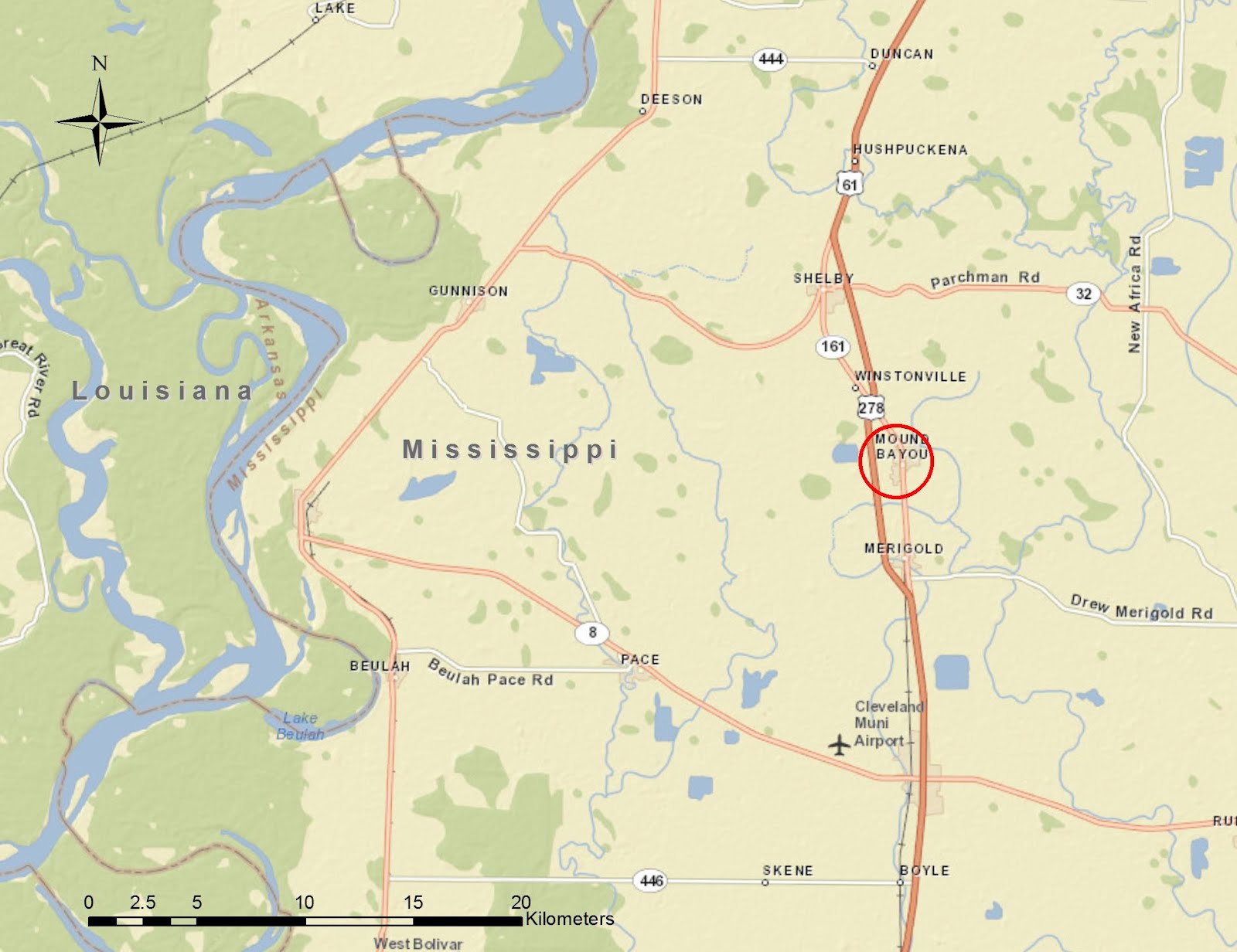
The city of Mound Bayou, in Bolivar County, is the next stop in our ongoing tour of the Mississippi Delta. Mound Bayou has an interesting history in that it was founded for and by former slaves. According to Wikipedia,
"Mound Bayou traces its origin to people from the community of Davis Bend, Mississippi. The latter was started in the 1820s by the planter Joseph E. Davis, who intended to create a model slave community on his plantation. Davis was influenced by the utopian ideas of Robert Owen. He encouraged self-leadership in the slave community, provided a higher standard of nutrition and health and dental care, and allowed slaves to become merchants. 
In the aftermath of the American Civil War, Davis Bend became an autonomous free community when Davis sold his property to former slave Benjamin Montgomery, who had run a store and been a prominent leader at Davis Bend. The prolonged agricultural depression, falling cotton prices and white hostility in the region contributed to the economic failure of Davis Bend. 
Isaiah T. Montgomery led the founding of Mound Bayou in 1887 in wilderness in northwest Mississippi. The bottomlands of the Delta were a relatively undeveloped frontier, and blacks had a chance to clear land and acquire ownership in such frontier areas. By 1900 two-thirds of the owners of land in the bottomlands were black farmers. With high debt and continuing agricultural problems, most of them lost their land and by 1920 were sharecroppers. As cotton prices fell, the town suffered a severe economic decline in the 1920s and 1930s."


This is Isaiah Montgomery's house on East Main Street. It is now closed and semi-secured. The undated black and white photograph is from the Mississippi Department of Archives and History. I think there is a horse grazing in the side yard, in keeping with he spirit of this town being the center of an agricultural community.

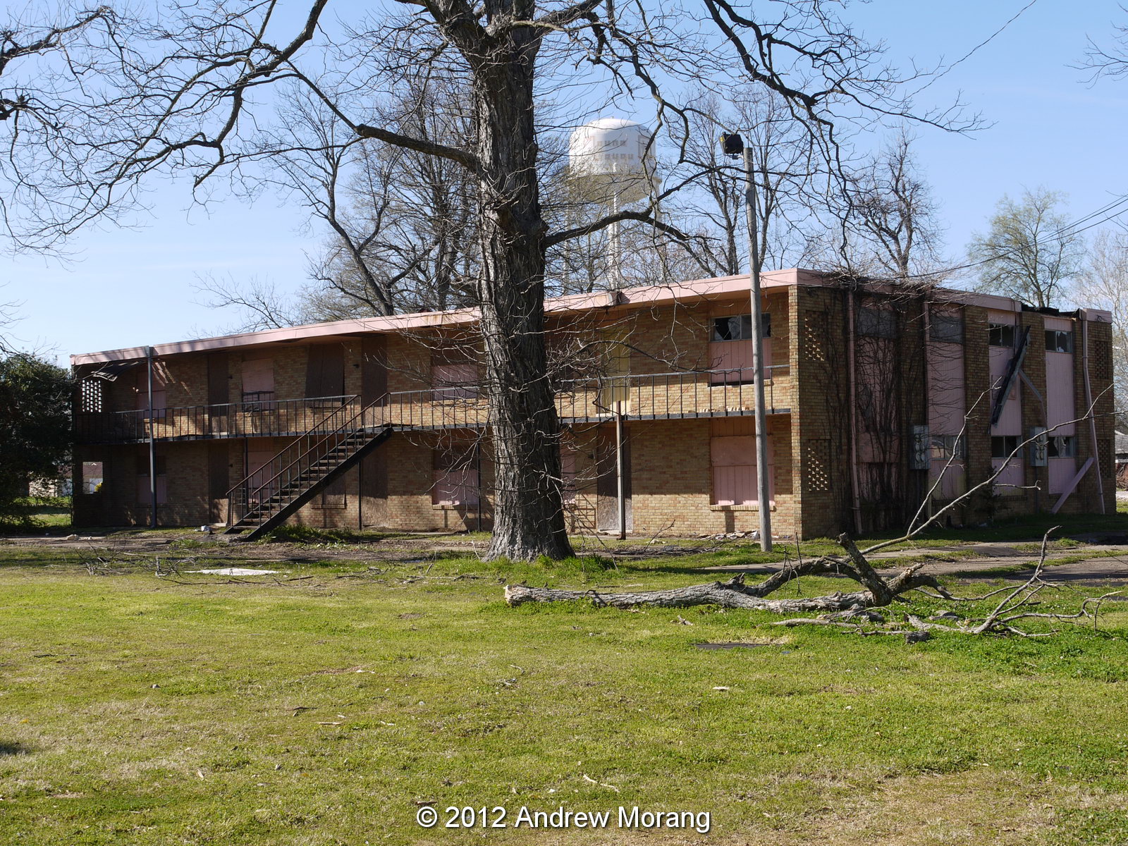
Mound Bayou has seen more prosperous days. Just north of Isaiah Montgomery's home is an abandoned low-income housing unit.


Further north on North Edwards Avenue is the historical Taborian Hospital, now closed. The hospital was founded by the International Order of Twelve Knights and Daughters of Tabor, a fraternal organization. For over twenty years, the hospital provided low-cost health care to thousands of African-Americans in the Mississippi Delta. This was one of two hospitals in the delta dedicated to serving this population group in an era when most public hospitals would only admit white patients. The other facility was the Afro-American Sons and Daughters Hospital in Yazoo City, featured in a November 2010 essay.


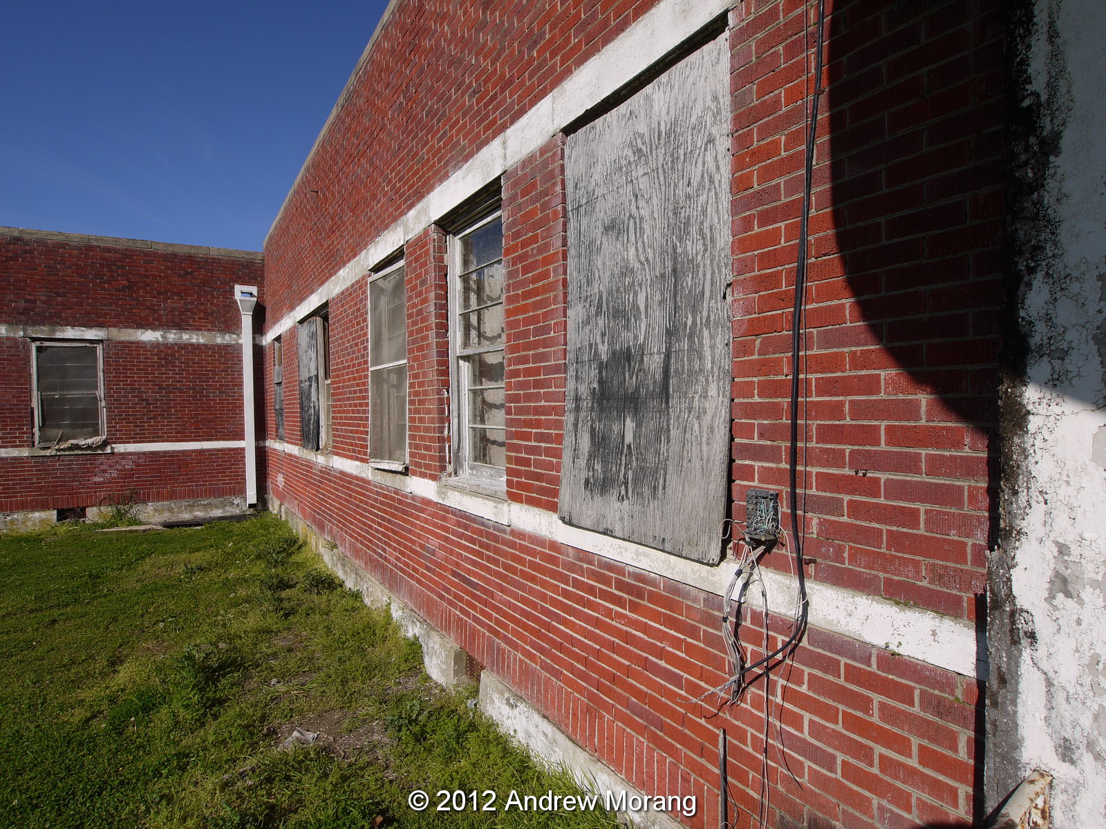
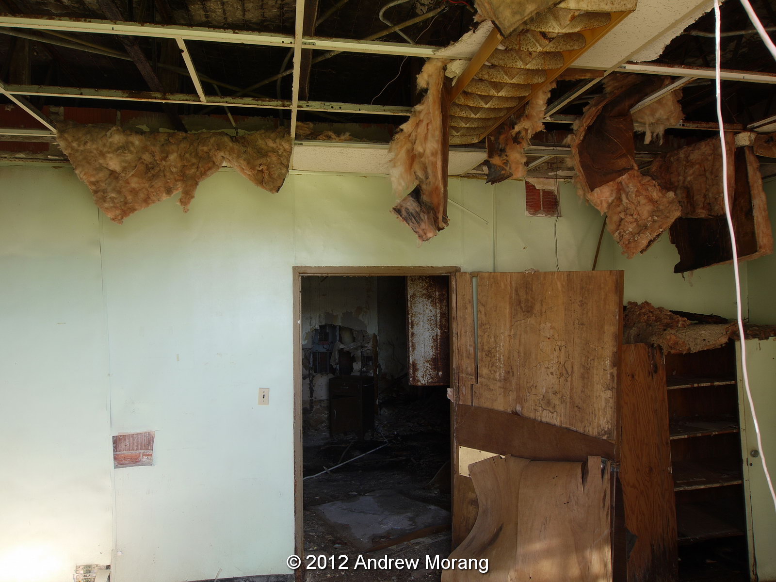
The Taborian Hospital opened in 1942. All members of the staff, including doctors and nurses, were black. Equipment included two operating rooms, an x-ray machine, incubators, electrocardiograph, blood bank, and laboratory. Operating funds were generated almost entirely from membership dues in the International Order and from voluntary contributions. The hospital closed in 1983, after years of financial pressures. As you can see in the last two photographs, the building is deteriorating and the interior is a mess.

The Preservation in Mississippi blog featured the Taborian Hospital in 2010. The following paper provides more background:

Smith, A.R.J.,  2003. Managed health care: the Taborian Hospital experience, 1942-1983. Journal of the National Medical Association, J. Natl. Med. Assoc. 95(1): 84–89 (avail. online, http://www.ncbi.nlm.nih.gov/pmc/articles/PMC2594372/ , accessed February 6, 2013). 

In 2000, Mississippi Heritage Trust placed Taborian Hospital on its 10 Most Endangered Places list. A rural development grant may revive the building, but I do not know when this will happen.

A 2012 article in Preservation in Mississippi has fascinating interior photographs taken before cleanup and restoration.

Here is a Mound Bayou photograph by Lee Russell from the Library of Congress:

"Title: Negros going to church, Mound Bayou, Mississippi
Creator(s): Lee, Russell, 1903-1986, photographer
Date Created/Published: 1939 Jan.
Medium: 1 negative : nitrate ; 35 mm.
Reproduction Number: LC-DIG-fsa-8a25117 (digital file from original) LC-USF33-011972-M2 (b&w film nitrate neg.)"

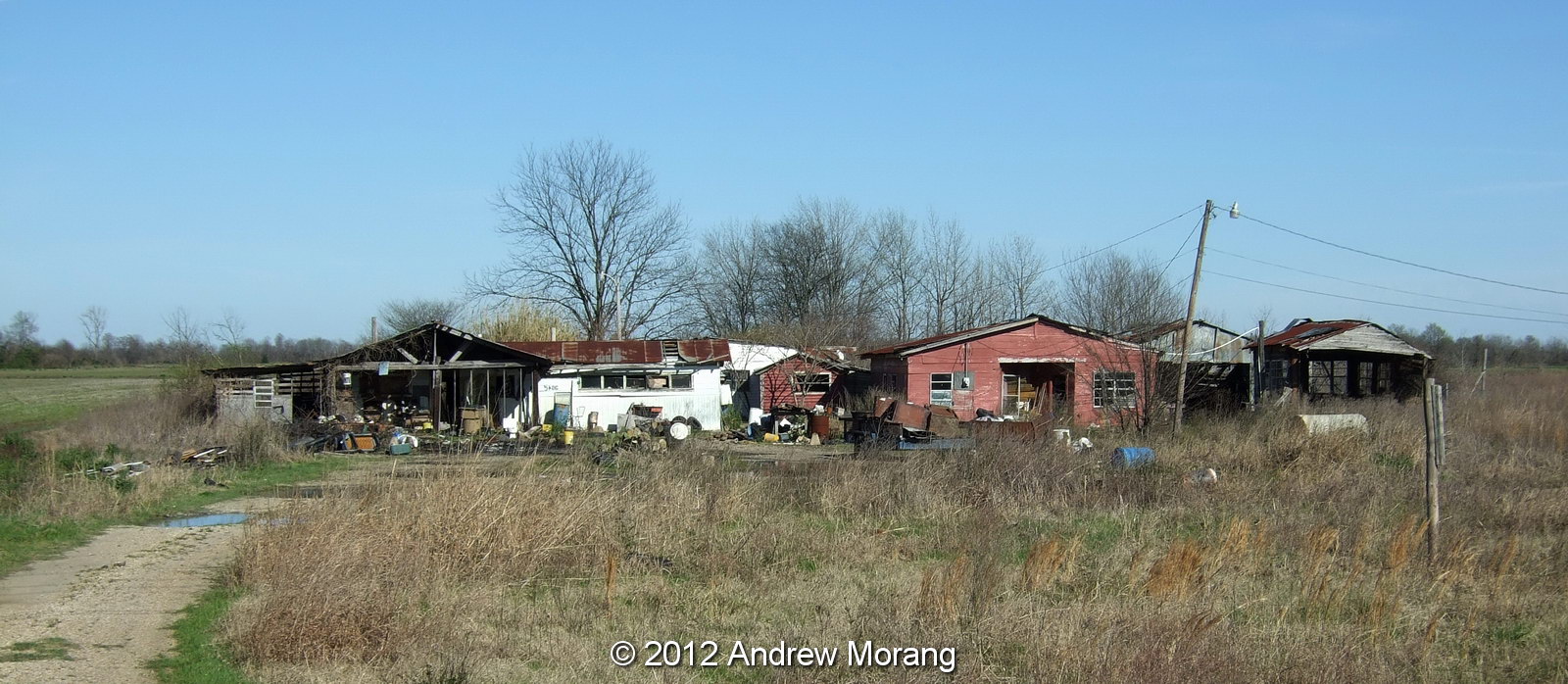
Heading north near Highway 61 are some run-down farm buildings.

Across the road, the flooded fields provide nice reflections.

Photographs taken March 10, 2012 with a Panasonic G1 digital camera with polarizing filter.

Update: here are two black and white film photographs of the Taborian Hospital. These are from Kodak Panatomic-X film exposed with a Fuji GW690II camera with 90mm ƒ/3.5 lens. I cleaned chemical blobs and lint using the heal tool in Photoshop CS5.

Thursday, April 12, 2012

Another Forgotten Vicksburg Road: N. Fisher Street


North Fisher is another one of Vicksburg's odd semi-hidden streets. Now you gain access from Hugo Street to the south. Once upon a time, the road snaked down the steep hill from Fort Hill Drive, but I am not sure if it is passable now.


I drove here in 2003 to photograph two houses on the City of Vicksburg demolition list. When the city inspector deems a house to be dangerous, sub-standard, or vermin-infested, and the owner cannot be located or refuses to make repairs, the city has the authority to demolish it. The spray-painted number indicates that the inspector had been to the property. The interior photograph shows the inside of No. 1507. The City used to fax the demolition list to me; then one day they said I had to go downtown and pay for photocopy reproduction. Odd.

Surprise, the second house was also No. 1507. Both are now gone.

The color photographs are scans of Kodachrome 25 film, scanned with a Nikon Super Coolscan 4000 as TIFF files. Nos. 1 and 2 were taken with a Leica M3 rangefinder camera with 50 mm f/2.8 Elmar lens. This was a 1970s version of the 50 with dual focus scale.  The black and white view of 1507 (the second 1507) is a scan of a 4×5-inch Tri-X sheet, exposed with a 75 mm f/8 Super-Angulon lens.  I developed the Tri-X in Kodak HC110 Dilution B.  This has been my normal development method since the 1970s.

Tuesday, April 10, 2012

End of the Road: Downhill Drive, Vicksburg, Mississippi

Downhill Drive is another one of Vicksburg's mystery streets.  It even has conflicting names in the various online map databases. It is a steep road that drops precipitously from Fort Hill Drive down to the west. I think the correct name is Downhill Drive, but it may also be Lower Fort Hill Drive or Elizabeth Street.

Drive down the hill (first gear for engine braking!) and you enter a forest with birds everywhere. It feels like you are far from anything except when a truck rumbles along just below on North Washington Street.


There are only a few cottages here, possibly 1940s-vintage. The blue one was deserted.  The previous resident owned a collection of electric trains and the plywood-mounted layout was in the porch along with a lot of equipment.


A nice lady came out of one of the houses while I was photographing and said she had owned the Chrysler since new. She might entertain an offer to sell it.

All photograph taken with a Sony DSC-R1 digital camera, tripod-mounted.

The end of the road: Short Sherman Avenue, Vicksburg, MS

As I have noted before, Vicksburg has a number of dead-end roads that few people visit. One of these is Short Sherman Avenue, which loops south from Sherman Avenue and stops at a former entrance to the Vicksburg Military Park. Once this road extended to Sherman Loop in the Park, but it has obviously been closed for years. If you hike the Al Scheller Boy Scout trail, you walk along the former roadway, now badly gullied.


There is not much here, just a few cottages, an old pig-breeding barn, and this rusting Chevrolet truck. Every year I see it getting progressively more covered with vines. Soon it will be engulfed with the creeping brush.


Here is an oddity: down in a gully is a surprising well-preserved Rexall Drug sign from Rose Drug. The paint must have been amazingly good quality because the colors are still vivid. A friend and I considered recovering the sign, but it is on Military Park property, meaning it is an archaeological artifact and therefore illegal to remove.

Digital images are from a Fuji F31fd compact digital camera.

UPDATE MARCH 2020: The sign is gone. A lady in a nearby house said some guys from a company that sells old stuff came and removed the sign.

Sunday, April 8, 2012

The Mississippi Delta 7: Boyle

Let us move further north into the Mississippi Delta. Unfortunately, I did not have time to explore Cleveland, which is the county seat of Bolivar County and home of Delta State University. But just south of Cleveland on Hwy 61 is the town of Boyle. Most motorists probably rush on through, but two sites caught my eye.


First was this lonely cemetery on the east side of the highway just south of town. There was no church on the site. Notice the skilfully-carved tombstone for a Miss Annie Gade, died Jan. 4, 1883, aged 2 Yrs. 3 Mos. & 20 Days. We forget what a terrible toll childhood diseases took on our ancestors. Never let anyone tell you we should go back to an era of simpler medicine without modern diagnostic equipment, sterilization of instruments, and, especially, inoculations against common diseases.


Further north, a more cheerful scene: this is the Daspot store where you can buy sunglasses and ladies' fashions. The proprietor was very cheerful when I asked permission to photograph the models.  The customers seemed a bit perplexed.

A profile view if you prefer....

Photographs taken with a Panasonic G1 digital camera.

Wednesday, April 4, 2012

Demolition of Hangar 3 at the Waterways Experiment Station, Vicksburg, Mississippi

Hangar 3 was one of four aircraft-type hangars acquired by the Waterways Experiment Station (WES) sometime in the late-1940s or early-1950s. When complete, it covered 58,700 square feet. Recall that WES is the research and development laboratory operated by the US Army Corps of Engineers in Vicksburg, Misissippi. After World War II, a lot of surplus military equipment and infrastructure was available, and I assume WES acquired these hangars from the Army Air Force or equivalent for free or at low cost.
Two of the hangars were used as shelters to cover hydraulic models. Hangar 3 was transferred to the Coastal Engineering Research Center (CERC) in 1983. CERC has now been incorporated into the Coastal and Hydraulics Laboratory (CHL). As the years go by, fewer and fewer physical hydraulic models are used due to high construction cost, water use, and time. Therefore, there is no need for some of the hangar space.
Not much is left in this interior photograph. But you can see why a hangar is a brilliant design: the strong arch allows a vast floor space to exist without the need for central pillars or supports. I assume originally these hangars could be lengthened as needed by simply adding more arch girders and roof panels.
The blue woven matting was used for wave dampening in hydraulic models.
The hangars were equipped with serious electrical supply (for pumps) and bright lights. During tests, paper confetti was thrown into the water and photographed with time-lapse photography. The cameras were mounted on walkways suspended way above the models.
It does not take long for a commercial demolition crew to tear down the metal panels with a cutting machine. So sad...

April 9, 2012 update: My wife informed me that the roof is totally down.

All photographs taken with a Fuji F31fd compact digital camera.
June 2015 update: Hangar 4 has also been demolished to make way for the new headquarters building.

Sunday, March 25, 2012

The Mississippi Delta 6: Leland

Leland is a town on U.S. Highway 61 (the Blues Highway) in Washington County, Mississippi. It is an agricultural center with soybeans, cotton, and catfish as its main commodities. Like many Delta towns, it looks like it was much more prosperous 20 or more years ago and is now sleeping in old age.

According to Wikipedia:

"Leland is in the heart of blues country and has produced a number of national and regionally famous blues musicians. Highway 61, mentioned in numerous blues recordings, runs through the town and gives its name to the community's blues museum. Leland is the burial place of the folk artist and blues musician James "Son" Thomas, who lived for many years along the railroad tracks. Thomas is buried beneath a gravestone donated by musician John Fogerty of Creedence Clearwater Revival.

Blues musician Johnny Winter was born in Leland on Feb. 23, 1944, to an Army officer and his wife. Winter is commemmorated on a plaque in the community that is part of the Mississippi Blues Trail.

The community is the birthplace of Kermit the Frog, a Muppet created by Jim Henson, who was born in nearby Greenville. The city has a museum along the banks of Deer Creek celebrating Henson's accomplishments."

Deer Creek runs through town, and some of the magnificent mansions attest to the wealth associated with agriculture in the past. These two are on North and South Deer Creek Drive, west of downtown.

Proceed downtown and you see where a cotton mill was once located. Most of the works have been demolished.


The tracks from the Yazoo and Mississippi Valley Railroad (later part of the Illinois Central) once ran north-south through the center of the Delta, but they were removed in the early 1980s. This was standard gauge 4 ft 8 1⁄2 in (1,435 mm) track. The Msrailroads web page has more information about historic Mississippi railroads. The post card from the John Sharp collection is courtesy of Msrailroads (Thanks!)

This is a June 1937 photograph of a cinema in Leland by Dorothea Lange, from the Library of Congress.

Proceed north on Main Street, and many of the shops and the former hotel are closed. As of 2000, this seed store was still in business.

I am not sure of the status of this elevator complex on North Main Street.

Out in the flat country near Dunleith, I photographed this classic little MB church in 2000. This was Mount Elm MB Church, and it was way out in the country, with no homes anywhere nearby.

Photograph note: the church and the feed store are scans of Kodachrome 25 slide film. I took the photographs with a 1949-vintage Leica IIIC rangefinder camera with 50 mm f/2.0 Summitar lens and a polarizer filter. The Summitar was a pre-WWII design and capable of superb results, especially if stopped down to f/4 or smaller. Hint: always use a tripod when photographing architecture. Your subject won't run away from you.

Dec. 2017 update: The Leica IIIC has been repaired and put back into operation (click the link).

Wednesday, March 21, 2012

More Cottages on Pearl Street, Vicksburg

Some of you readers may remember my 2010 post on historic Pearl Street, in Vicksburg, Mississippi. As I wrote then, many of the early-20th century houses had been or were in the process of being torn down. Here are some more examples of architecture along that road (from my 2006 files).

This is No. 2114 Pearl. Notice the sun awnings running along the entire front. The siding is a type of asphalt tile patterned to look like stone blocks. I recall these were common in the mid-20th century, durable and providing some degree of insulation.

Here is No. 2118, nicely restored with vinyl siding. The Kansas City railroad yard is behind and down the hill.

No. 2123 was a substantial cottage and has been boarded up for years.

This nicely-painted cottage on a landscaped lot is No. 3513 and has a view of the bend of the Mississippi River.

Finally, this handsome cottage at 3607 Pearl. I will look through the archives for more Pearl Street examples.

All photographs taken with a Sony DSC-W7 compact digital camera.