Saturday, May 20, 2023

From the Kodachrome Archives: Athens and Central Greece in 1951

Background


My father moved to Athens, Greece in February 1951. He had just returned to USA from an overseas position in the Pacific, spent a week job-hunting in New York City and was offered this posting. He visited relatives in Boston and Orlando, bought a few supplies and clothes, boarded Pan Am, and left for Greece. He traveled light and efficiently (unlike his son).

Greece must have seemed exotic. But he had read classical literature, and Greek architectural features were popular in early 20th century American buildings. On weekends, he had time to explore. He sometimes had access to the company car and by mid-year, bought a new Chevrolet. 

He and other American engineers lived in hotels for a few months and then found apartments. He co-rented a flat near Kolonaki Square with two other Americans within easy walking distance to the office on Merlin Street. The flat came with a man-servant who did laundry and cooking. 

Here are some examples from approximately 1951 and 1952 (plus one from 1957). My dad did not label his slides, so I am guessing the dates based on his diaries. For some frames, I know the exact date because he wrote a detail like "went to the market with two cameras." At that time, Kodak did not print the processing date on the cardboard slide mount. He used his 1949 Leica IIIC camera with its 5cm ƒ/2 Summitar lens (both of which I still use 70 years later). 


Athens


Hadrian's Arch and the Acropolis
East side of the Parthenon. 
The Parthenon (built 447 to 432 BC).  

I remember when you could walk all over the Acropolis site and climb up into the massive temple. Today, visitors must walk on wooden boardwalks. The millions of tourists were literally wearing out the stone. 

Think of the awesome passage of history during which this temple has stood. Aristotle may have walked among the columns. More recent visitors have included Lord Byron, Winston Churchill, Harry Truman, Dwight Eisenhower, Princess Elizabeth, Agatha Christie, Vladimir Putin, Elizabeth Taylor, Margaret Thatcher, Barack Obama, and Bill Clinton. 


Checking out the Cariadids on the Maiden Porch of the Erechtheion.


As of 1957, these Cariadids were originals. But in subsequent decades, air pollution disfigured them and Greek authorities removed for safe-keeping, They are now in the Acropolis Museum. In their place are replicas based on an example in the British Museum. The one in London, taken to Britain by Lord Elgin, had been preserved indoors are was largely intact. 


Temple of Olympian Zeus (construction 6th century BC to 2nd century AD)


This scene has not changed much over the decades. There may be some tall building in the background now.


1994 view of the Acropolis and Phaleron Bay from Lycavitos mountain (Kodachrome 25, Leica M3 camera, 135mm Tele-Elmar lens)

This is a modern view of the Acropolis taken at dusk. 

Central Greece


According to my dad's diary, this was a 1951 4-door Chevrolet Sedan Skyline Deluxe. He ordered it from a Chevrolet dealer in Athens but paid by sending a check to General Motors in USA. It cost $1629 plus some extra for hubcaps and a spare tire. A ship delivered it, along with cars that other American engineers had ordered, to Piraeus. He got it out of customs on August 6, 1951.

I vaguely remember this Chevrolet. I used to stand up in the back (this was the era before we worried about car safety). I recall him telling me that in the early 1950s, only diplomats and Americans could afford to own cars. Recall, Greece was very poor because it had been looted by the Nazis during World War II and then suffered three years of brutal civil war. An automobile was a luxury item. Petrol was a luxury.

Somewhere in central Greece near Volos

Once, tourists dressed properly. Today, Americans look like homeless people.


View of Volos looking west

Pelion


Plateîa with Platanos trees, Zagora, Greece

Zagora is a cheerful mountain town perched on the Pelion Peninsula facing east towards the Aegean Sea. My grandfather's family came from Zagora, and the municipal office has records dating to the late-1800s. 


Lady of the Lake (stream), near Zagora, Pelion, Greece


Closing notes


Consider what an amazing amount of information is stored in these 70-year-old slides. And it is accessible! All you need to do is look at the slide with a magnifier. It is a time machine into the past. As long as the slides are not damaged by fire, flood, or fungus, some sort of optical device, like a camera with a macro lens, will be able to retrieve this image data for decades to come. Will our hard drives loaded with digital jpeg files be readable in 70 years? Will people look at a billion cell phone dump Instagram uploads on the "cloud" in 70 years? 

In those days, it was a challenge to get the Kodachrome processed. In that era, Kodak included processing with the purchase of the film. I remember my dad  telling me that he would give an exposed roll to an American who was returning to USA. The colleague would send the film to Kodak when he was back in USA. Then he would take the slides back to Greece or give the package to another American heading to Athens. He would also deliver fresh rolls of film. Turnaround must have been months. This would certainly not suit the modern Instagram generation. Greece is dry, which helped preserve these slides and retard growth of fungus.

I scanned these Kodachrome slides with a Plustek 7600i film scanner operated by SilverFast software. Most frames were almost perfect with the Auto CCR setting. On a few frames, I used the neutral grey dropper to correct the color. Afterwards, on some frames, I cleaned lint and splotches with the heal tool in Photoshop CS5. I resized for web display with XnViewMP. Please click any frame to see it magnified.


Saturday, May 13, 2023

Tragedy in Rolling Fork, Mississippi

March 24, 2023, tornado path (from AccuWeather via Yahoo)

On Friday, March 24, 2023 around 8:00 pm, a tornado rated at EF-4 tore through west central Mississippi. It touched down just southwest of the small town of Rolling Fork before moving northeast toward Midnight and Silver City and then continuing toward Tchula, Black Hawk and Winona. 


Tornado path within Rolling Fork (from 25ABC)

In Rolling Fork, the terrific winds flattened many blocks of the little town, flipped cars, knocked down the water tower, and shredding trees. The storm killed 26 people that night in Mississippi, with 16 in Rolling Fork. It is a town of fewer than 2,000 residents. Muddy Waters claimed it as his hometown.   

The town was a real mess. We could not drive on the side streets away from US 61, but that was enough to show the damage.


The truck's horn abruptly started beeping when we were next to it. Some power company employees climbed up to it and thumped the body. The horn stopped.

Power company crews repairing electric lines
Scott Petroleum at 19840 US-61 (Samsung phone photo)

Highway 61 had already been bulldozed clear by March 28. 

Have a seat, Hwy 61

The State Police were routing through traffic on Hwy 1 around Rolling Fork. But US 61 was open for repair trucks, supplies, and ambulances.

Snapped tree, Race Street

Note how the tree has been shattered but the nearby house was intact. Astonishing.

Deer Creek

Deer Creek starts in Bolivar Lake and winds its way south through the Mississippi Delta. I have taken pictures in Onward, Leland, and other small towns through which Deer Creek flows.


The water truck (Samsung phone photo)
Water donations at Sharkey-Issaquena Academy

The tornado tore through the Delta while my wife and I were in Houston. We drove home via Shreveport, Louisiana. We bought water in Shreveport to donate because we thought most bottled water supplies anywhere near the disaster zone would be gone. But as of Tuesday afternoon, March 28, there was plenty of water on pallets. Still, the volunteers were glad to have our packages. 

The tornado knocked down Rolling Fork's water tower. I do not know the status of a repair. 

For more photographs of tornado damage, Reuters posted an excellent collection taken from drones and by news reporters on the scene.

I hope the residents can rebuild and put their lives back together. 

The little town of Silver City was also devastated. I have not been there for post-storm pictures. But I have photographed there in 2020 and 2022 (click the links). 

I took these photographs on Kodak Portra 160 film with a Pentax Spotmatic camera and the 35mm ƒ/3.5 Super-Takumar lens. Dwayne's Photo developed the film and I scanned it with my Plustek 7600i film scanner. 

Saturday, May 6, 2023

Revisiting the Wards, Houston, Texas (TX 10)

Introduction


The Wards are former political subdivisions of Houston, Texas. They no longer officially exist but still represent approximate regions of the city. Their inhabitants associate with their home ward. 


Houston Wards in 1920 (from Wikipedia, in the public domain)

This 1920 map shows the Wards at that time. Note that Hermann Park is in the bottom center of the map, in the countryside then. A hospital was already at the south side of Hermann Park. Just south of this today is the huge Texas Medical Center, with world-famous hospitals including the University of Texas MD Anderson Cancer Center

The little rectangle at the lower left is West University Place. The community, first developed in 1917,  never became incorporated into the City of Houston. Today, West U is a fashionable and upper-crust community to call home. 


Fourth Ward


Shotgun house, 1410 Robin Street (Ilford Delta 100 film, Rolleiflex 3.5E camera)
Historic wood houses, 1320 Robin Street (Ilford Delta 100 film)

Much of the Fourth Ward that I remember from the early 1980s has been totally transformed with modern townhouses and condominiums. A small cluster of wood houses on Robin Street is (or was) being preserved.

These buildings are in the Heritage Freedman's Town. This was the oldest African-American part of Houston and pre-dates 1865. A local resident told us that the City was trying to preserve a small cluster of the worker shotgun cottages. She said the local residents were upset because a contractor had been chosen without local input and there had been little or no progress in a long time.

The Houston Freedman's Town Conservancy is trying to preserve the heritage and the brick streets.


Fifth Ward


Locomotive approaching Lyons Avenue (Panatomic-X film, 80mm ƒ/2.8 Planar lens)

The Fifth Ward was formerly a working class neighborhood, where many of the men worked at the Port of Houston and at associated industries. Several rail lines cross through the Ward (see my previous article on Tower 26), and I saw warehouses, workshops, and other commercial activity.

Brewster Street, view north (Panatomic-X film, 250mm ƒ/5.6 Sonnar lens)
Brewster Street cottages (250mm ƒ/5.6 Sonnar lens)
Bleker Street (250mm Sonnar lens)
Waco Street (250mm Sonnar lens)

As I wrote in my earlier article, some of the Fifth Ward is really rough. Some blocks of row houses look reasonably well-maintained, but others are horrifying. I did not feel too comfortable exploring on my own and did not take too many photographs. It reminded me of west Jackson, Mississippi.


Third Ward


Restored row houses, Holman Street (Ilford Delta 100, Rolleiflex 3.5E camera)

The Project Row Houses is an art program at 2521 Holman Street. Art exhibits are in some of the houses, while residents occupy others. According to the Row Houses web page:

Project Row Houses is a community platform that enriches lives through art with an emphasis on cultural identity and its impact on the urban landscape. We engage neighbors, artists, and enterprises in collective creative action to help materialize sustainable opportunities in marginalized communities.

Project Row Houses occupies a significant footprint in Houston’s Historic Third Ward, one of the city’s oldest African-American neighborhoods. The site encompasses five city blocks and houses 39 structures that serve as a home base to a variety of community-enriching initiatives, art programs, and neighborhood development activities.


PRH programs touch the lives of under-resourced neighbors, young single mothers with the ambition of a better life for themselves and their children, small enterprises with the drive to take their businesses to the next level, and artists interested in using their talents to understand and enrich the lives of others.

Although PRH’s African-American roots are planted deeply in Third Ward, the work of PRH extends far beyond the borders of a neighborhood in transition. The PRH model for art and social engagement applies not only to Houston, but also to diverse communities around the world.


Former local store, Holman Street at Emancipation (Fuji Acros film)
Fixer-upper house, Bastrop Street at Francis (50mm ƒ/2 Jupiter-8 lens)
No more ice cream, Ennis Street
Unity of Color, 3611½ Bennett Street
The Secret Recipe - well, not any more, 3801 MacGregor Way

The Third Ward is a mixture of light commercial and residential, partly decayed, and partly reviving. 

North of the Gulf Freeway (I-45), the area now called East Downtown has become very sophisticated with restaurants, town houses, and garden apartments. Brass Tacks is a very nice coffee bar and casual restaurant. I biked there several times on the Columbia-Tap Rail Trail.

Further south, the scene becomes a bit more earthy without as much redevelopment (yet).

This completes our short and semi-random tour around three of the Houston Wards. There is plenty more to see. Next trip. Thanks for riding along.

Saturday, April 29, 2023

From the Archives: Washington Avenue, Houston, 1981 (TX 09)

In the long-ago earlier life, my wife and I moved to Houston, Texas, in 1980. The big city! There was so much to see and explore! 

Having a real job and some income, I bought a used Rolleiflex 3.5E camera at Southside Camera Center (long gone). What do you do with your first medium format camera? Well, start looking for interesting urban decay topics. Back then, Houston was full of grunge and decay. (Some critics say Houston is still full of grunge, but we better not go there this time.) As you long-term readers can see, I have been doing this decay topic for a long time. 


My 1956 Rolleiflex 3.5E camera with its superb 75mm ƒ/3.5 Xenotar lens - why did I stupidly sell it when I though digital might be the next great thing?

Washington Avenue runs approximately east-west out of downtown Houston, Texas, through the former Sixth Ward. Washington Avenues in US cities are typically older streets that run through well-established and often run-down neighborhoods. This one fit the pattern in 1981. Here are some samples. Please click any frame to see it enlarged.


Turney Motor Company occupied a 1920s gas station building. You could drive a Chevrolet Nova for $35/week - it says so!

The building is gone, and the lot provides parking for the trendy Ivy House cocktail bar next door. Washington Avenue was not very trendy in 1981....

Houston Junk, now possibly Rose Recycling on Center Street
Time for a 50¢ beer, corner of Center and National Streets
Historic 1872 Glenwood Cemetery, an oasis of green and peace in the city
June 1980 view of Houston from Glenwood Cemetery (Kodak Panatomic-X film, Nikkormat FTn camera, 28mm ƒ/3.5 lens)
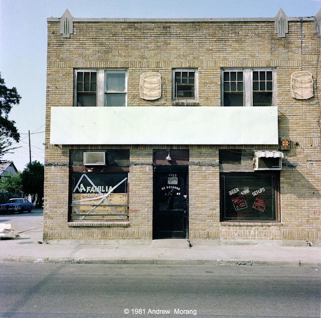
Early 20th century brick commercial building, 1722 Washington Avenue 

In the mid-20th century, all American cities had commercial buildings of this type. The families who ran the shops or small businesses often lived in apartments on the second floor. White flight to the suburbs after World War II destroyed many traditional and mixed inner city communities that would have depended on local shops in such buildings. 

This building is gone and a modern town house/condominium is in its place. At least in Houston, the cycle is turning and professionals are returning to live within the city. 

Early 20th century wood cottage Washington Avenue. 

This was one of my early examples of photographing dilapidated houses. This building is gone, probably demolished years ago. A large framed print of this scene has hung in my house for four decades, but the print has changed colors and faded.  


This handsome old fire station is still extant
Gent with his laundry, 1712 Washington Avenue

This is another example of an early-20th century commercial building. Note the formerly handsome tall arched windows. The lower floor had ventilation transoms. 

I took these photographs on 120-size Kodak Vericolor II Film with my Rolleiflex on September 5, 1981. The colors are a bit muted, but all in all, the film survived the decades quite well. In those days, you could buy 120 film in many camera stores, but professional emulsions, like Vericolor II, came from larger stores with a film refrigerator. This roll probably came from Southside Camera Center on Bellaire Blvd.

Thank you for joining me for this look back to 1981. I also wrote about Main Street in 1982 (click the link).

Saturday, April 22, 2023

Downtown Houston in November 2022 (TX 08)

In November (2022), I wandered around downtown Houston. Everything is so modern, big, and overwhelming, it was hard to find the type of subject matter I like. Thanksgiving Day was gloomy but also uncrowded compared to normal. Here are a few scenes from the area near the Amtrak station and around Buffalo Bayou just north of downtown.

Amtrak


Bail bonds, a ubiquitous part of the American justice system, 1418 Washington Avenue

I found some 1981 negatives of Washington Avenue. Stand-by for a future post.

Houston's decidedly uninspiring Amtrak station (250mm ƒ/5.6 Sonnar lens)
Waiting for the train, Houston Amtrak station

Houston once had three passenger railroad stations. Only one remains, the magnificent 1911 Union Station. The main concourse of the former railroad station has been reused as a clubhouse, cafe, team store, office space, and lobby at Minute Maid Park (previously known as Enron Field until the financial scandal). They did a superb job of refurbishing the elegant entry hall. 

Today, Houston, once the railroad hub of the southern United States, has one uninspiring Amtrak station. The waiting room looks like a bus station. But, if you are energetic, you can take the sleeper all the way to Los Angeles. 

I arrived at the Amtrak station before the eastbound train was scheduled to arrive. When it rolled into the station, it was pulling two private rail cars at the end of the Amtrak cars. Then another locomotive pulled these two private cars away and shunted them to a siding, connecting them to a third private car. The elegant way to travel.


Downtown and Buffalo Bayou


Apartment blocks east of the Gulf Freeway (I-45) (250mm Sonnar lens)

Houston now has hundreds of residential units downtown. Compared to the 1980s, when I recall the downtown being mostly commercial, the city has become trendy.  


Buffalo Bayou and University of Houston Downtown (Panatomic-X film, 50mm Distagon lens, orange filter, 1/8 ƒ/11.5)

The University of Houston Downtown occupies the 1930 Merchants and Manufacturers Building. The building is over the site of Allen's Landing, where the Allen brothers landed and established the city of Houston in 1836. The bridge in the distance is the Main Street viaduct.


“Main Street viaduct, Houston, Texas, 1910,” Houston Waterways, accessed April 5, 2023, https://digitalprojects.rice.edu/wrc/waterways/items/show/1310.

Under the Main Street viaduct (80mm Planar-CB lens, 3-sec. ƒ/4.0½)

This 1910 concrete arch bridge carries the tram as well as cars over Buffalo Bayou. Despite the no camping signs, a group of homeless were camped there. They shared space with Muscovy ducks, who waddled around without concern. 


Waiting for the tram, view south towards downtown Houston (50mm Distagon lens)
Victorian House on Hamilton Street - being moved? (80mm Planar-CB lens, 1/15 ƒ/4.0½)

Third Ward


The MacGregor Tire Shop - but I'll pass (80mm, yellow filter, 1/30 ƒ/8)


Fourth Ward


No shopping today, 1122 West Grey (Fuji Acros film, Leica M2, 50mm ƒ/2 Jupiter-8 lens, 1/250 ƒ/5.6)

There are still bits and pieces of an older Houston on West Grey, but most of it has been redeveloped with modern condominiums. I have negatives from this area from the early 1980s when it was more "earthy." Another project to scan....


Corrugated metal warehouse, 1515 Spring Street (Panatomic-X film, 80mm Planar-CB lens)

This interesting warehouse and the store above are remnants of older structures in the Fourth Ward. Not many are left. I will write more about the wards in a future article.

Texas Medical Center


Room with a view: Greenbriar Drive and the Houston METRORail (250mm Sonnar lens)

The area south of the Texas Medical Center is commercial and rather uninspiring. But hundreds of apartments and temporary residential units cater to medical patients. Huge parking lots serve thousands medical staff. But it is a food desert if you can't stomach fast food. Fortunately, Rice Village and its amazing restaurants are only two miles away. 

The METRORail tram can take you to the Medical Center, Hermann Park, the Museum District, with its 19 museums, or all the way downtown. METRORail is free if you are over 70.


Port of Houston


The Port of Houston is an immense economic engine for Texas and the USA. It is the second largest port in Dollar terms in the USA, after Port of Los Angeles/Long Beach. Annually, some 22,000 deep-draft ships come in and use the 50-mile Houston Ship Canal and the Port's complex of wharfs, terminals, and refineries. The Houston Ship Canal needs regular (almost constant) dredging from its opening at the Gulf of Mexico mouth at Galveston, across Galveston Bay, and up the Buffalo Bayou. My 1981 car (still in use) came in through Houston. 

Take the free tour of the Port of Houston. Cruise right by these immense freighters. 

This ends out somewhat random wandering around Houston in November and early December. Thank you all for riding along! Click any photograph to see it enlarged. Most of these photographs are from my Hasselblad 501CM medium format camera.