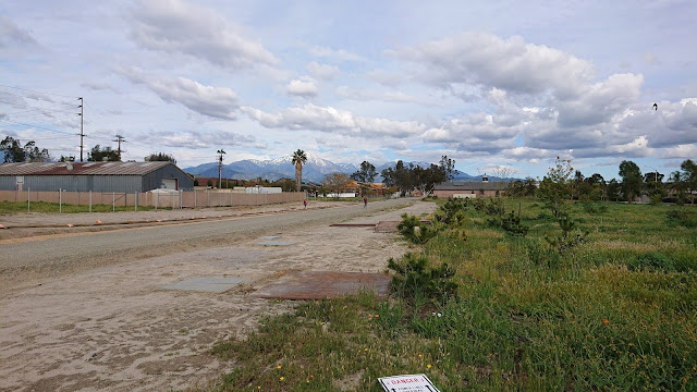
Thursday, May 28, 2020

Travels on the Mother Road, Route 66: Part 13b, Santa Rosa, New Mexico (2019)

Will Rogers Drive (Route 66), Santa Rosa, NM at sunset (Tri-X 400 film, Hasselblad 501CM, 250 mm Sonnar lens)

Santa Rosa is the county seat of Guadalupe County, New Mexico. It is an unusual town to be in arid New Mexico because of its artesian lakes. These natural sinkholes in the limestone bedrock bring pure clear cold water to the surface. The pioneers of the mid-1800s must have found it to be a life-saver after crossing to desert. Even Route 66 travelers in the mid-20th century would have found a swim in the Blue Hole to be a relaxing relief on a hot summer day. According to Wikipedia,
The east-west highway through the town was designated as U.S. Highway 66 in 1926, and the increase in traffic made the community a popular rest stop with motels and cafes. Santa Rosa's stretch of Route 66 is part of film history. When John Steinbeck's epic novel, The Grapes of Wrath, was made into a movie, director John Ford used Santa Rosa for the memorable train scene. Tom Joad (Henry Fonda) watches a freight train steam over the Pecos River railroad bridge, into the sunset.


In August 2017, on a 90+° F day, a swim in the Blue Hole was chilling and fun. But on this (2019) trip, the temperature was well below 50° F, so no swim. But I did stay overnight in a Route 66 motel and spent a few hours exploring. The La Loma was clean and cheap, with a 1960s ambience. The Joseph's Bar and Grill next door was pretty bad. Santa Rosa is not a foody place.

Rio Pecos truck stop, Route 66, Santa Rosa (Tri-X 400 film, 80mm Planar-CB lens)
Will Rogers Drive (Route 66), Santa Rosa (Moto G5 digital file)

Sadly, Will Rogers Drive is not very busy now. The old Rio Pecos sign at the closed truck terminal is a characteristic Route 66 photograph topic.

In the morning, I drove around town. Most of it is rather rough, with numerous unoccupied buildings. Some are wood frame, while others look like old adobe block with plaster facing.


S. 9th at Campos (near the Blue Hole), Santa Rosa (Tri-X film)
Shotgun house, Santa Rosa
Shotgun house with intact metal roof, Santa Rosa (Moto G5 digital file)
Shed or tiny house made of adobe blocks with partial plaster veneer (Moto G5 digital file)
No more lunch at the Comet, Santa Rosa (2017 photograph)

This ended my short stay in Santa Rosa. Sadly, there is not much to keep a traveler here for long. But it is a piece of Route 66 history.

Friday, May 22, 2020

Travels on the Mother Road, Route 66: Part 8d, Budville and Cubero, New Mexico (2019)

Continuing east on Route 66 (where it still exists) or I-40 through central New Mexico, the country is pretty arid with only an occasional farm or truck stop. According to the Route 66 Adventure Handbook, Cubero was bypassed by a new road in the 1930s. An entrepreneur built the Villa de Cubero, which is still in business on Route 66 where it diverges away from the interstate. You can buy snacks, gasoline, and other essentials there.
Courtesy of 66postcards.com (Thank you!)
The Villa de Cubero Tourist Courts catered to early Route 66 travelers. According to the Route 66 Adventure Handbook, the adventure/musical Desert Song was filmed near here (the 1943 or 1953 version?). Desert Song was based on Sigund Romberg's 1926 operetta about a galant and handsome desert sheik who captures the heart of the beautiful city girl and rides off to the desert with her, singing all the time, while he also directs the revolt of the Berber tribesmen.
Villa de Cubero De Luxe Tourist Court (expired Kodak Ektar 25 film, Yashica Electro 35CC camera)
The tourist courts are closed but in reasonably intact condition. The Route 66 Adventure Handbook also notes that Ernest Hemingway may have written The Old Man and the Sea here! Or maybe he did not because he might have been in Cuba. A blog from the Villa de Cubero explores the controversy of Papa Hemingway's stay in the tourist court. We need to weigh the options:
Cuba: tropical breezes, palm trees, beautiful women, lots of booze, and deep sea fishing.
Cubero: desert, not much to do, and booze.
Budville Trading Co. (Moto G5 digital file)
About a mile southeast on old Route 66 you come upon the former Budville Trading Company. It is closed and longer has pumps on the island.
Budville Trading Post (Tri-X film, Hasselblad 501CM camera, 50mm ƒ/4 Distagon lens)
A bit further east I saw another closed garage/filling station. This one had another long-wheelbase Cadillac!

That is all the excitement for Cubero. We will continue east on Route 66. Standby for more updates.

Saturday, May 16, 2020

Travels on the Mother Road, Route 66: Part 8c, Continental Divide, New Mexico (2019)

At the continental divide (Kodak Ektar 25 film, Yashica Electro 35CC camera, polarizing filter)
Heading east from Gallup, the country is pretty bare, with rock ridges and occasional small farms or ranches. We reach a small community known as Continental Divide. Needless to say, there is a souvenir shop and "Indian Market" on the site. It is a popular stop on I-40. In the parking lot, I spoke to a gent with a Studebaker Avanti - a real Avanti from 1962 or 1963, not one of the versions made later by other companies after the Studebaker factory closed forever  in December 1963. He was driving from California to a car show in Florida. A friend hiked some of the Continental Divide National Scenic Trail (3100 mi. in total) several years ago and would have passed through the nearby town of Grants.
Is this really the Continental Divide? (Moto G5 digital file)
A sign explains that water falling west of the sign flows westward towards the Pacific (actually, to the Gulf of California), while east of the sign, water flows to the Gulf of Mexico and eventually reaches the Atlantic Ocean via the Gulf Stream oceanic current.
Continental divide in the United States. Map from ESRI ArcMap software.
In the map above, you can see that the Rio Grande river approximately parallels the Continental Divide in New Mexico. At El Paso, Texas, it turns southeast and becomes the border between the United States and Mexico. Much of the water is taken out for agriculture, but a small amount eventually reaches the Gulf of Mexico. In central Colorado, runoff flows into the Arkansas River, which joins the Mississippi River a few miles southeast of Pine Bluff, Arkansas. To the west, the Colorado Plateau is highly arid, but what water does fall as snowfall or occasional rain enters the Colorado River. Most of this water is also removed for agriculture, leaving almost nothing for the Gulf of Colorado.
This map (from Wikipedia) shows the major hydrologic divides in North America. Note how water that falls in the central United States flows to the Gulf of Mexico, much of it via the Mississippi River and its tributaries. The Great Basin is an arid region that has no outlet. Rainfall in the eastern region flows to the Atlantic Ocean via numerous small rivers, none of which even begin to approach the Mississippi River's volume.

Saturday, May 9, 2020

Travels on the Mother Road, Route 66: Part 8b, Gallup, New Mexico (2019)

Route66 view east, Gallup, New Mexico (Hasselblad 501CM, 250mm ƒ/5.6 Sonnar lens)
Gallup was the "big town" on Route 66 in western New Mexico. It was a popular stopover for Hollywood film starts in the era of Western movies. Today, it is a hub for people from remote stretches of the Navajo Nation and from lonely ranches to stock up on household supplies, liquor, and drinking water (and probably drugs). The town is pretty rough, with liquor stores, payday loan shops, and detox centers. Homelessness is a big problem.

The old Route 66 parallels the railroad tracks and still features old motels, gas stations, fast food dives, payday loan shops, and other establishments that cater to travelers. I-40 is on the north side of the tracks, and many travelers just rush by, skipping Gallup entirely.


Many of these old motels are still in business. During two previous visits to Gallup, I stayed in the famous El Rancho Hotel, which formerly hosted Hollywood stars, who came to Gallup during filming of Western movies. But this trip, the El Ranch was rather expensive and I opted to enjoy authentic Route 66 ambience (and save $$) by staying in a old-time motel. I found one, the El Capitan, which looked a bit less dive-like than the ones in the photographs above. My room was clean and the proprietor friendly. My co-travelers were a mixed bunch: many oil field workers, some tourists, and some bums.
The El Rancho, where I stayed in 2016 (Fuji X-E1 digital file)
If you stop in Gallup, you really need to enjoy the hospitality and ambience of the El Rancho, unless you really prefer a dive motel.
The El Morro theater, on Coal Avenue, is still in business. According to Wikipedia, "The El Morro Theater in Gallup, New Mexico was built in 1928. It was listed on the National Register of Historic Places in 1988. It was deemed notable as "the only example of Spanish Colonial Revival architecture in Gallup." It was designed by Carl Boller, of the Boller Brothers architectural firm."
4th Street, Gallup, New Mexico (Kodak Ektar 25 film, Yashica Electro 35CC camera)
This one belongs in color: a garage on 4th Street with murals. I saw a number of buildings like this - well done!

I only spent one night in Gallup and did not look around too much. It looks like the city is trying, but most of the town is dumpy. A friend of my daughter taught school in Gallup as part of the Teach for America program. She reported that it was very difficult because the poverty was horrifying, coupled with deep-seated drug and alcohol issues. That sounds like so much of rural America on our race to the bottom.

The square photographs are from Kodak Tri-X 400 film and my Hasselblad 501CM camera. The color frame of the garage on 4th Street is from the long-discontinued Kodak Ektar 25 film in a 35mm Yashica Electro 35CC camera.

May 6, 2020 update: Gallup and the Navajo Nation have suffered severely from the Coronavirus. The State of New Mexico had to invoked the Riot aw to lock down the city. "The lockdown comes as state and local authorities grapple with one of the worst coronavirus outbreaks in the United States on the nearby Navajo Nation, the country’s largest Indian reservation, and a surge in detected cases in places near the reservation." (from NY Times)

Sunday, May 3, 2020

Virus in Vicksburg - a Quick Overview (B&W film)

Introduction


Dear readers, I will take a short interruption from my Route 66 series to write about the Virus in Vicksburg. The coronavirus has caused almost unprecedented disruptions to commercial activity around the world. I wrote "almost unprecedented" because the great flu influenza of 1917 caused similar confusion and disruption to the World War I generation. Worldwide, the 1918-1919 influenza may have killed between 50 and 100 million people (from Dr. Fauci in a CNN Special). 

Read The Great Influenza: The Story of the Deadliest Pandemic in History by John M. Barry to see how the world coped at that time. We Americans were much tougher and less selfish and self-obsessed back then. But even then, we had political appointees who underplayed the danger of the flu for commercial reasons, which led to thousands of excess deaths. And then we had idiots who did the "masks impose on my rights" nonsense. Especially sobering to read are details of the second wave of influenza in late 1918. This second wave may have accounted for the majority of deaths around the world, many in poor regions like India. In total, about 675,000 Americans died. Will we see a second wave of COVID this time? (Update: Yes!)

A New Jersey friend asked if I had been taking virus pictures around Vicksburg. I wondered, how could I show what was different than normal? A hundred photo web pages recommend lame virus exercises such as "How to photograph an egg in creative light" or "Get closer to your pet or your broccoli for the most impactful portraits." OK, maybe if you are totally confined indoors and are totally bored. But here in Vicksburg, Mississippi, we arre not confined indoors, and I thought of some topics.

Quieter streets


Photographers around the world have shown pictures of their normally mobbed streets being completely empty. The Weather Channel had an article documenting penguins, lions, bears, bison, and other critters reclaiming now-empty city streets. Vicksburg has also been quiet, but it does not look drastically different from normal, and we do not have bison or penguins. The streets here have traffic but usually not bumper-to-bumper. As a bicyclist, the quiet streets are very welcome. Night-time is gloriously quiet. The mayor wisely enacted a curfew from 11:00 pm to 05:00 am, and for once we do not hear crapped-out jalopy cars clunking down the street at all hours of the night, rap music thumping. Now, we can hear tree frogs or an occasional tug on the Mississippi River. It would be so nice if this curfew stayed in effect indefinitely.

The Vicksburg from the corner of Monroe and China Streets (Kodak Panatomic-X film, Rolleiflex 3.5E with 75mm ƒ/3.5 Xenotar lens) 
Spring Street view north, Vicksburg, Mississippi, USA (Panatomic-X film, Hasselblad 501CM, 250mm ƒ5.6 Sonnar lens)
Polk Street view east, Vicksburg, Mississippi (4×5" Tri-X film, 135mm ƒ/4.5 Schneider Xenar lens)
Speed Street view west, Vicksburg, Mississippi (Rolleiflex 3.5E Xenotar, Tri-X 400 film)

On this last picture, I caught a car in motion. Normally, Speed Street is much busier

Casinos


They are are closed! Normally, they are open 24 hours. The casinos are situated along the banks of the Mississippi River. Here are two examples.

WaterView Casino closed for virus (4×5" Tri-X Prof. film, 180mm ƒ/5.6 Caltar IIN lens)
Ameristar Casino closed for virus, Vicksburg, Mississippi, USA (4×5" Tri-X film, 90mm ƒ/6.8 Angulon lens)

No more tour boats


Up through February (2020), three or four river tour boats per week moored at the Vicksburg waterfront. The river cruise business was devastated by the 2007-2008 recession but had nicely recovered. The tourists took busses to the Vicksburg National Military Park, to museums, and to some of the churches. I am not sure if they spent all that much in town, but it was nice to see visitors. This is a photograph of the "America" moored at the waterfront during happier times in 2019. We also saw many visitors from Europe, especially music lovers who drove Route US 61, the "Blues Highway," but they, too, are not here now.

Paddlewheeler "America," Levee Street, Vicksburg, Mississippi (Fuji Acros film, Voigtlander Vito BL camera, 50mm ƒ/3.5 Color-Scopar lens, Leitz polarizer)

Industrial activity


The Port of Vicksburg is still operating, but traffic is definitely less. 18-wheeler trucks still rumble by with timber, lime, cement, or petroleum products, but there are fewer private cars and pickup trucks. The tank cars in the photograph below have been sitting on the siding for months. Possibly they are being used to store refined petroleum, but I am not sure.

Haining Road view east, Vicksburg, Mississippi (4×5" Tri-X film, 180mm ƒ/5.6 Caltar IIN lens)

Haining Road view west, Vicksburg, Mississippi (4×5" Tri-X film, 180mm ƒ/5.6 Caltar IIN lens)

Lesser changes


Even the gas stations are a bit quieter some of the time. But some places in town look about the same as ever. Clay Street has a lot of traffic. The dudes of a certain demographic still hang around the gas station convenience stores and the car wash places, as if they did not read the warnings about not gathering in groups. And almost none of them wear masks. They think they are immune?

Top Five, 1108 Bowmar Avenue, Vicksburg, Mississippi (Leica IIIC, 50mm ƒ/1.4 Canon lens)

Closing comments


The virus restrictions have been more relaxed here than in many big cities, where people had to stay indoors for weeks. I live in a big old southern house and have plenty of chores and repairs to do. My wife and I can go out and take photographs, walk, or ride bikes. We have coped with no issues at all. We did not consume or ingest any disinfectant or malaria medicine as per the "medical" recommendations from the White House.

We were fortunate that Vicksburg's mayor was proactive about closing businesses where people gather. And, at least initially, the Governor of Mississippi was more cautious and medical-directed than many other southern governors. The State Health Officer has served the citizens of Mississippi diligently. Compare and contrast with the political hacks in Georgia (Kemp), Florida (DeSantis), South Dakota (Noem), and Texas (Greg Abbott). But Mississippi's opening the economy still proved deadly for health outcomes. And the autumn school schedule turned into a shitstorm (a wildly chaotic and unmanageable situation, controversy, or sequence of events) when the Governor mandated that schools open on schedule in his attempt to suck-up up to President Trump and/or Senator Hyde-Smith.

One benefit of having a bit more spare time was reviving my 4×5 inch Tachihara camera. I was embarrassed that I had not used it since 2012. The equipment to xpose big pieces of film and take real photographs sitting in a closet, year after year? I retrieved the kit from the closet, checked the lenses and shutters, and loaded some film holders in a dark closet. At first, I was awkward, but the technique came back quickly. The Tachihara is a wooden field camera and must be used on a tripod. Press photographers in the 1940s successfully hand-held 4×5" Speed Graphics (you have seen them in movies accompanied with big flash bulb reflectors), but mine does not have any sort of rangefinder. I even bought a 1960s Schneider 90mm ƒ/6.8 Angulon lens, a tiny optic that is easy to carry.

Here in town, I found a handy advantage to the reduced traffic: I can set up a tripod in a street and not have any issues. If I wear my orange National Park Service vest, some drivers stop, thinking that I am a surveyor or city employee.

We will get through this. So will you Urban Decay readers. Be well, be careful, don't go stupid with this "reopening the economy" propaganda and go to bars, casinos, Republican political rallies, motorcycle rallies, or parties. And don't forget to photograph your world, explore, and leave a film legacy for your descendants.

Monday, April 27, 2020

Travels on the Mother Road, Route 66: Part 7c, Jack Rabbit and Holbrook, Arizona (2019)

Jackrabbit Trading Post, Joseph City, Sep. 4, 2019 (Kodak Ektar 25 film, Yashica Electro 35CC camera, polarizing filter)
 We will continue our drive east through Arizona. Near Joseph City, not much remains of Route 66, just the frontage road to I-40. West of town proper was the famous Jackrabbit Trading Post. A billboard with the logo "HERE IT IS" may be one of the best known Route 66 sights. Hundreds of tourists pose in front of the sign or sit on a big jackrabbit on the other side of the interstate. For the photograph above, I waited for some people to take their pictures and leave, and caught a BNSF train thundering through.
Room with a view, Joseph City (Fuji X-E1 digital file)
The terrain around Joseph City is a bit severe. I stopped in Joseph City during my 2016 trip but totally missed the Jackrabbit sign. The town has some urban decay material.
Dinosaur, 2214 Navajo Blvd., Holbrook, AZ (Kodak TMax 400 film, Hasselblad 501CM, 80mm planar lens, polarizing filter)
Holbrook was another old-time Route 66 town. There was not much of interest on Business 40, and I completely missed the Wigwam Village Motel. Fortunately, I visited a sister Wigwam Motel on Foothills Blvd. in Rialto, California, in 2016 (see Mother Road article 1). Here in Holbrook, I was pleased to see dinosaurs in town. The truck was sort of interesting, as well.

Tuesday, April 21, 2020

Travels on the Mother Road, Route 66: Part 7b, Twin Arrows, Arizona (2019)

Dear readers, we are back to Route 66, the Mother Road. On my 2019 western trip, I revisited some Route 66 towns that I passed through in 2017 and checked out some spots that I totally missed before. I will continue the trek from west to east as before, and will number the locations in the same pattern as before, for example, with Part 7 being Arizona.

Twin Arrows is an abandoned rest stop, trading post and gas station just east of Flagstaff. It is distinguished by a pair of steel arrows sticking out of the ground. As noted in the Route 66 Adventure Handbook (fourth ed.) "This is the type of feature which so distinguishes the old highway's attractions from today's cookie-cutter copies." It is a pity no one has tried to revive this rest stop, but possibly Flagstaff is too short a distance to the west, and travelers would just head into town if they needed gasoline or snacks.
The original Twin Arrows, near Flagstaff, Arizona (Kodak Ektar 25 film, Yashica Electro 35CC camera, polarizer)
As you can see, there is not much left to the place. Fortunately, in this dry climate, the arrows will not corrode for years. Maybe one day they can find a new home in front of a museum or similar attraction.

Most of these views are digital files from a Moto G5 mobile phone.

Standby for more 2019 Route 66 updates. For a quick stop in Seligman, Arizona, during this 2019 trip, click this link.

Wednesday, April 15, 2020

The vacant lots of downtown Redlands, California

(Guest post by morangm)

Most of Kodachromeguy's posts here feature abandoned and decaying rural towns in areas that are losing population and economic activity - places that are just no longer needed. In today's post, I'm going to talk about a different situation - decay caused not by decreasing population and economic declines, but rather decay in the midst of rapid growth, caused by self-defeating municipal ordinances.

Redlands, California, is a cute historic town about 60 miles east of downtown Los Angeles.  Although it was originally an independent town settled by wealthy easterners seeking a pleasant climate for retirement and those seeking their fortunes in citrus cultivation, it has long since become attached to the ever-expanding Los Angeles metropolitan area.  This area of California, the "Inland Empire", is one of the fastest-growing regions of the country.  According to a recent demographic analysis by the City of Redlands, 80% of people who live in Redlands do not work in Redlands, and 80% of people who work in Redlands don't live in Redlands.  So, while Redlands fiercely clings to its historical identity, it is no longer a self-contained entity.  Like it or not, it is part of a broader metropolitan community.

In the 1970s, 1980s, and 1990s, Redlands voters, alarmed at the rapid growth of the region, adopted some slow growth municipal ballot measures and propositions. These measures, among other, more technical things, limit the number of new dwelling units that can be built within the city limits each year to 400 and cap the height of new buildings.  Redlands is by no means the only municipality to adopt slow growth measures like this, and it is exactly these types of restrictions, adopted by many communities across metropolitan areas, that have contributed to urban sprawl and worsening traffic congestion.  If you don't build up and in, you have to build out.

Redlands has a small but relatively lively and pedestrian-friendly downtown area which spans for about 4 blocks along State Street, with some activity in the surrounding blocks.  Unfortunately, despite the region's overall economic growth, the area immediately west of downtown has declined in recent decades.  The Redlands Mall, built in 1977, was placed squarely in the middle of what was once State St., bulldozing many historic buildings and effectively cutting off the main downtown corridor from the other end of State St.  The I-10 freeway cut the city in half, blockading the northern residential areas from downtown. Additionally, the freight and passenger rail corridor ended service at some point, and various industrial and warehousing businesses closed up.

The slow growth restrictions in Redlands meant that redeveloping these central areas of town was not economically viable for developers.  The Redlands Mall has sat abandoned for 10 years (which doesn't sound like much, but remember this is one of the fastest-growing regions of the country we're talking about!).  There are many other vacant lots and abandoned buildings that no one is willing to invest in.  Developers just can't turn a profit redeveloping a downtown area in California if they can't build upwards.
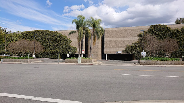
Redlands mall
The abandoned Redlands Mall
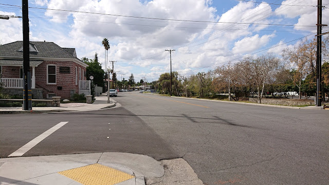
West State Street
West State St, the part cut off from downtown by the Redlands Mall, with the Chamber of Commerce on the left.
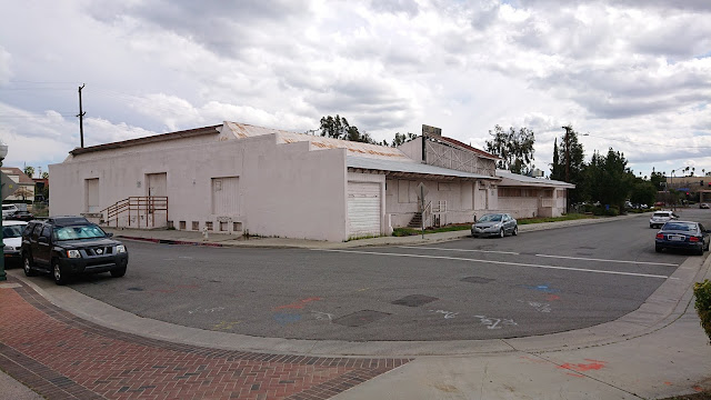
Abandoned warehouse or packinghouse
Abandoned warehouse (possibly a citrus packinghouse?) right next to downtown
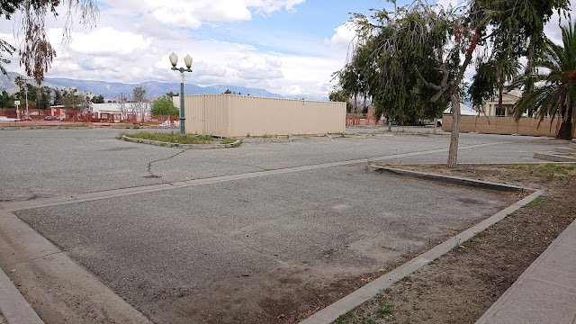
Vacant lot
Vacant lot and parking lot downtown. The backside of the abandoned warehouse is in the background.
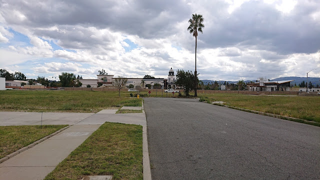
Empty dead end
Empty dead end downtown with Studio Movie Grill (formerly the Krikorian Cinema) in the background
Abandoned house
Abandoned house abutting the highway (in the background)
Unused parking lot
Unused parking lot currently being utilized for construction storage. This will probably become parking for the adjacent rail station. I think this is the site for the newly-planned parking garage.
Rail corridor
Empty land and the newly-graded rail corridor
Boarded-up historic trolley
Hey, I found a trolley!
The Los Angeles commuter rail system, Metrolink, is currently expanding its service out to Redlands, revitalizing the old abandoned rail corridor and the historic Santa Fe depot.  As part of this effort, the City of Redlands got a grant to develop a really great transit-oriented development plan to guide redevelopment efforts for the area around the three new rail stops, which encompasses the Redlands Mall and other vacant and abandoned areas in the downtown core.  City staff and hired consultants spent over a year developing this long-term plan for walkable, bike-friendly, mixed-use development.  They held a series of public workshops to learn what the community wanted and to solicit feedback on the plans.

The plan, called the Transit Villages Plan, lays out new zoning for the plan area, allowing buildings of 4 stories on average (with some sections of up to 5 stories allowed for architectural features) in the central part of downtown, with building heights tapering off as you get farther from downtown.  The plan also specifies various architectural requirements to maintain the character of the town and prevent ugly big square boxes from being built, etc.  It seemed like a good plan!  It would help us to redevelop the decayed areas of downtown, encourage environmentally responsible and sustainable development patterns, accommodate necessary and desirable growth in a controlled manner, and ensure that we maintained the charm and character of the city.

However, the City's vision for this new denser, mixed-use development couldn't come to fruition with the existing voter-approved slow growth restrictions in place.  So, the City put on the March 2020 ballot a new measure, Measure G, which would remove the old slow growth restrictions for the area within the Transit Villages Plan area (so, not the whole city, but just the downtown core).

Redlands went nuts!  In the month or two preceding the Measure G vote, a vigorous public debate broke out in the local newspapers and social media.  Although response to the Transit Villages Plan at the community workshops had seemed largely positive, there was immense pushback to Measure G.  NIMBYism took hold. People didn't want to encourage more development in Redlands, didn't want to welcome new apartment-dwelling neighbors, and didn't want their views of the mountains obstructed by taller buildings downtown.  But the debate was wild.  Measure G's actual text was technical and confusing, and the City did a poor job of proactively explaining what it meant in lay terms and even explaining how the urban planning process works, what zoning is, what the existing measures were, etc.  By the time the City finally released an FAQ that laid out clear information, the conspiracy theories had already made the rounds, people's emotions had already been roused, and the local Tea Party had organized in a serious way to oppose the measure.

Measure G failed miserably. About 65% of voters opposed it.

So what does this mean for the vacant lots and abandoned buildings of downtown Redlands?  It remains to be seen.  The City will have to redesign the Transit Villages Plan to conform to the old slow growth measures.  Will developers be willing to invest in these properties given the limitations?  We don't know.

Further confusing the problem is that the State of California has been aggressively pursuing legislation to increase the housing supply across the state, precisely because municipal slow growth measures like those in Redlands are driving up housing costs and encouraging sprawl.  Some state legislation actually removes municipal new housing unit limits, so even without Measure G, parts of our slow growth limits are moot.  The state is also requiring communities to provide large numbers of new housing units over the next several years.  It's unclear to me exactly how this works, but my understanding is that if a City's zoning code does not conform with state requirements on housing provision, the City has no grounds to say no to a developer proposing housing units in whatever form.  Thus, we may end up with denser high-rise development downtown anyway, but it won't be subject to the Transit Villages Plan's careful architectural guidelines. We may be stuck with whatever the developer wants to build with no local say in the matter.  We might also end up bulldozing our few remaining orange groves on the outskirts of the town and turning them into housing developments, and people will build Granny flats in their garages or backyards.  And if we don't conform to the State's requirements, we risk losing state funding for things like road construction.

So, the future of Redlands remains pretty uncertain for the moment.  The way I see it, the failure of Measure G seems fairly self-defeating.

To be clear, there is some activity happening among all the vacant lots.  The new Redlands Packing House District shopping center has been successful, Escape Brewery moved into the old Rondor building (a former trolley depot), and there's a new market-style eatery in the works in another old packinghouse.  But none of this helps the housing situation, and it's not the walkable mixed-use development we envisioned in the Transit Villages Plan.
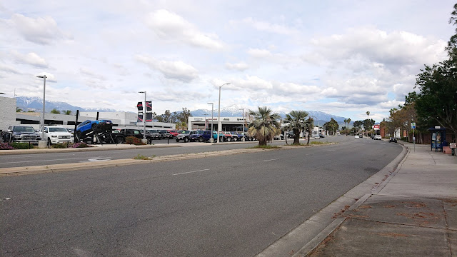
Redlands Blvd
Redlands Blvd just west of downtown. Perhaps the now-empty part of downtown will eventually look like this?
Further reading:
Because Kodachromeguy always does this: All photos in this post were taking with a Sony Xperia XZ2 Compact smartphone.  And for the record, Redlands almost never has this many clouds in the sky.