Showing posts with label Versapan. Show all posts

Wednesday, December 14, 2022

Return to Country Stores in Central Mississippi and Louisiana

Introduction

Years ago, rural residents depended on a country store that was close enough to reach on foot, wagon, or horse. These stores provided for most of their needs, such as groceries, seed, tools, sewing supplies, and hardware items. Today, most have closed and people drive to the supermarket or Walmart. We have lost part of our 19th and 20th century cultural background. Here are some country stores in central Mississippi and one in Louisiana. I have photographed some of them before but wanted to revisit them and see some new ones.  


Florence


Most of the scenery along Hwy 49 between Jackson and Hattiesburg is boring strip mall Americana, very uninspiring. But a few traditional stores linger in dilapidated strip malls like this one in Florence.  


D'Lo


D'Lo is a small town a short distance off Hwy 49 southeast of Jackson. It is mostly known for the water park, but there is an old commercial strip downtown. Most of the stores are closed.


Satartia


Satartia is a village off MS Route 3 between Vicksburg and Yazoo City. The last time I photographed the little store in Satartia, a fluorescent light was on inside, but I did not see any commercial activity. This is a 4×5" Tri-X frame taken with a 135mm Schneider Xenar lens.


Utica


This is the Harris Carmichael store on Hwy 27. The building is in good condition but I do not know when the business closed.


Edwards


This is the Morning Star Store on Old Port Gibson Road at the junction of Adams Station Road (GAF Versapan film). It has been closed for years.


This store is on Military Road near Edwards. Based on the size of the pine tree, I think there has not been any activity here for years. This a Panatomic-X photo taken with a Hasselblad and the 50mm ƒ/4 Distagon lens.


This is the Watley Store at 116 Bill Strong Road in near Edwards. 


Burk's Gro is on Cook Road west of Edwards. The day I took this picture, a guy came up to me and asked what I was doing. Duuh, taking a photograph. 


Midnight


Not much is left of this store on old US 49E in Midnight (name of the town). This is a Hasselblad exposure with the 80mm Planar lens.


Polkville


Vicksburg


This may not quite qualify as a country store. Let's call it a country liquor store. I seldom see cars parked outside and am not sure how much business it gets. 

Tallulah, Louisiana


This is the former Poboy Don's on Route 602 east of Tallulah, Louisiana. I recently biked by the store when some gents were repairing it to use as a hunting lodge. They said the building was post-World War II vintage. I photographed it years ago when it served po-boys (see Country Stores 15).  

Thank you all for riding along for this quick overview of country stores. There are many more in Mississippi and Louisiana, but I need to end this article. 

Monday, May 17, 2021

Historic Bridge over Judd Bayou, Tensas National Wildlife Refuge, Louisiana

Tensas National Wildlife Refuge is a magical place of forest, bayous, lakes, and wetlands. The last verifiable sighting of the Ivory-billed woodpecker was 1944 in these forests. Some diligent birders are still looking for the ivory-billed here, although I think they will have more success in the remote and rugged mountain forests in Cuba. The Louisiana Digital Library has photographs of the woodpecker and the forests when they were still largely pristine.

During the 2020 Audubon Christmas bird count, one birder volunteered to explore the woods along Judd Bayou. I had never been to that area and decided to check the access in mid-December. To reach the bayou, you take Charles Brown Road off US 80 just east of Waverly and follow it south over I-20. It passes farms and then enters the forest at the boundary of Tensas NWR. Abruptly, you are in a forest from another time. Where is the dinosaur? The road runs parallel to the Tensas River along its west bank. It ends at an old-fashioned riveted steel girder bridge with a sign that cars are not allowed to cross. 

Judd Bayou bridge (Kodak Ektar 25 film, Hasselblad 501CM, 80mm ƒ/2.8 Planar-CB lens)
The late afternoon light was perfect, and I took a frame on the long-discontinued, ultra high resolution Kodak Ektar 25 film. Click the picture to expand to 2400 pixels wide to see details.

Bridge details from the Louisiana Department of Transport:

  • Parish: Madison
  • Bridge Configuration: Through truss Pratt truss
  • Bridge name: (none)
  • Facility carried and feature crossed: OLD HWY 80 over JUDD BAYOU
  • Year built: 1908
  • Owner: Bureau of Fish and Wildlife, Federal ownership

The LADOT information about Hwy 80 is almost surely incorrect because 80 ran E-W through north Louisiana, approximately following the main railroad line. I doubt it made a big swing south into this forested region, which was formerly known as the Singer Tract (owned by the Singer Sewing Machine company).  

A 4-wheeler track may lead south from the bridge, eventually connecting to Quebec Road, but I am not sure. I could not go further in my car, but it was a lovely setting, and I did not see any dinosaurs or ivory-billed woodpeckers. Imagine the magnificence of these forests if they had not been logged and destroyed in the 1940s.

Forest near Rainey Lake (Kodak Panatomic-X film, Rolleiflex 3.5E Xenotar lens)
Forest off Quebec Road (Kodak Panatomic-X film, Rolleiflex 3.5E Xenotar lens)
Here are two examples of the magnificent hardwood bottomland scenery from 2019. 
Farm on Charles Brown Road (GAF Versapan filmVoigtländer Vito BL camera)
Barn on Charles Brown Road
Tensas NWR is a bit out of the way but well worth a diversion to visit. 

Write your Federal representatives to support and expand the National Wildlife Refuge system, as well as National Monuments. Protect the wild lands that we still have; leave a legacy for your descendants. Undo the mismanagement, pillage, corruption, and destruction of our natural environment wrought by the previous administration in Washington.

Tuesday, April 27, 2021

Tracing Vicksburg's Rail Line South

Introduction


Most Vicksburg residents are familiar with the convoluted route that the Kansas City Southern freight trains take through town. Trains cross the old Mississippi River Bridge, turn north, and either go to the rail yard at Levee Street or ascend parallel to Pearl Street and then turn inland to head towards Jackson. However, there is also a southern extension that now gets little use. At one time, the tracks ran as far south as Eaton Lighting off US 61 south (near the municipal airport), and trains would have served Eaton, the now-defunct Mississippi Chemical Company, and other industries. 

The history of rail in this area is complicated, and I can't begin to understand it. In the late 1800s, several companies extended tracks almost as far south as the Big Black River. In 1883, the Louisville New Orleans & Texas Railroad absorbed existing track and rebuilt it to standard gauge to use for part of their Memphis-Vicksburg-Baton Rouge-New Orleans main line. I do not know when this service ended, but today, no track extends south of approximately Magnolia Road (near Rainbow Farms). No tracks have run to Port Gibson in many decades.

I have shown pictures of the Kansas City Rail yard at Levee Street before. My articles in Trackside Photographer or here at Urban Decay trace the main KCS line through Vicksburg. Here I will trace the lesser-used track that runs to the south starting at the Frontage Road (north of I-20). Access is limited; maybe I should build one of those rail-bicycles that some people use to ride on defunct rail lines. Surprisingly, the Mapquest map still shows the rail line all the way south to Fayette, even though the tracks have been gone for decades. If you look at the map and then switch to the satellite view, you can often see vegetation or property boundary changes that mark the former rail embankment. 

Southern Route


Red circles mark locations of the following photographs proceeding north to south (from ESRI ArcGIS)
KCS tracks from Frontage Road (Fomapan 100 Classic film, Hasselblad 501CM camera, 80mm ƒ/2.8 Planar-CB lens)
This is where the southern line starts. The track at the lower right is the one we will follow in the following photographs. 
Frontage Road bridge (Tri-X film, Hasselblad 501CM camera, 80mm ƒ/2.8 Planar-CB lens, green filter)
The rail lines run on the opposite (west) side of Stouts Bayou. The bayou is just beyond the brush in the photograph above and the track is visible in the clearing.
Rail line passing under I-20 bridge (GAF Versapan film, Spotmatic II, 135mm ƒ/3.5 SMC Takumar lens, yellow-green filter)
Rail line next to Iowa Blvd. (GAF Versapan filmVoigtländer Vito BL camera)
Iowa Boulevard drops down from the Frontage Road near the Parkside Play House and passes under I-20. Many people take this road as a shortcut to Walmart. The track here also passes under I-20 and runs straight through woods with the next access at Rifle Range Road.
At Rifle Range Road, the track splits. One branch crosses a nasty creek and leads to Halcros Chemicals. The right track above continues south a short distance.
Halcros Chemicals, Rifle Range Road (Tri-X film, Hasselblad 80mm lens)
As this photograph shows, an occasional tank car is brought to Halcros Chemicals. These tracks once continued further south (beyond the sheds) and served the Mississippi Chemical Company. According to Google Maps aerial photographs, those tracks are gone. 

Mississippi Chemical operated from 1953 to 2002, when the parent company declared bankruptcy (according to The Vicksburg Post). Over the years, the company made pesticides, fertilizers, rocket fuel, nerve gas, and other industrial chemicals. Toxins and arsenic seeped into the ground, and part of the area needed to be cleaned as a Superfund site. How many rail cars carried rocket fuel or nerve gas on these tracks over the decades?
Wood bridge with Halcros Chemical beyond (Panatomic-X film, Spotmatic camera, 35mm Super-Takumar lens, fill flash)
Unused (abandoned?) timber rail cars (Panatomic-X film, Spotmatic camera, 55mm ƒ/1.8 Super-Takumar lens, yellow-green filter)
The other track (the one on the right side in the photograph above) only continues a few hundred meters south until you come across abandoned (or permanently parked?) timber railroad cars. They seem to continue indefinitely. What are they here? Are the wheels and steel not worth reusing?

Beyond the timber rail cars, the track continues almost to Warrenton Road, according to Google Maps. At Warrenton, the rails are gone, and the old bed under the bridge has grown in so much, you can't tell that track once ran there.
Former rail embankment at Willow Drive, view south (Tri-X film, Hasselblad camera, 250mm Sonnar lens, yellow-green filter)
Former rail embankment at Mop Lane, view north
Further south, the old embankment is being mowed by someone. Why? Will this right-of-way be used by some entity? 

Just north of the Vicksburg municipal airport, tracks once turned west into the Westinghouse (later Cooper and now Eaton) electrical equipment factory. A friend who started work at Westinghouse in 1976 said rail cars delivered heavy materials, like coils of copper, for about two years (until about 1968). Afterwards, trucks delivered all supplies and eventually Westinghouse removed the rails and changed the loading dock. 
Warrenton Lane (GAF Versapan film, Voigtländer Vito BL camera)
By the time you reach Warrenton Lane, near the Cedars Elementary School, the right-of-way is overgrown. You can see a bit of track disappearing into the brush.

A few miles south, only a short stub of track remains near the former Marathon Letourneau plant at Letourneau road. Further south, the terrain is wooded, and the railroad right-of-way is hidden or lost. But you can trace the former right-of-way on aerial photographs.

Port Gibson


Former rail line under Ingleside Karnac Ferry Road (GAF Versapan Film, Vito BL camera)
As I wrote above, decades ago, the rail line extended south to Port Gibson and then further to Baton Rouge. I was not sure if I could find any remnants of the old line, but while driving on Ingleside Karnac Ferry Road, I was surprised to cross a modern bridge over a distinctive V-shaped valley. A dirt road ran in this valley, but the large amount of gravel gave it away and the former rail line. The photograph above is from the bridge looking north.
Depot, Market Street, Port Gibson (GAF Versapan film, Vito BL camera)
The 1884-vintage Yazoo and Mississippi Valley Railroad depot is in Post Gibson at 1202 Market Street. It was converted into a restaurant in 1977 but is not in use now. Many of these railroad depot restaurants do not last long. Someone ambitiously renovates the buildings, but after a short burst of energy, the restaurant closes. A Mississippi Department of Archives and History Historic Sites Survey describes the depot. 

This has been our short excursion on the southern rail extension. Thank you for riding along.

Saturday, February 27, 2021

Expired Film Treasure: 135-size GAF Versapan Black and White Film (Abandoned Films 04)


Background


Dear Readers, this will be a continuation of my irregular series about discontinued photographic films ("Film from the Dead"). It sounds very photo-geeky, but don't worry, there will be urban decay examples and even some "pretty" pictures. 

I have written about older films before. Long-term readers may remember that in spring of 2020, my friend gave me a cooler full of GAF Versapan 4×5" film packs. He had stored them in freezers since the 1960s. They proved to be completely viable, and I liked the results so much, I looked for other sizes of Versapan film on eBay. Amazingly, a fellow listed three rolls of 135 size (regular 35mm) with 1974 expiration, which he claimed had been frozen. Well, that was too good to resist, so I bought them. 

Some of you old-timers may remember when GAF sold many types of film in the United States (I am not sure about foreign distribution). The black and white emulsions were well-regarded, and I do not know why they stopped production of consumer products in the 1970s. This was 30 years before the digital tsunami overwhelmed the film companies, so digital is not a culprit here. GAF stands for General Aniline & Film Co., an old-line film company from Binghamton, New York. The history of this company is complicated and was intertwined with ANSCO and Agfa. Read a more detailed history on Mike Eckman's excellent review of an ANSCO Super Regent camera. 

Technical Notes


I loaded my first roll of Versapan in a Pentax Spotmatic II camera at exposure index (EI) of 100 and used part of the roll around Vicksburg. Then I exposed the second half in my Leica M2 camera. I sent the roll to Northeast Photographic in Bath, Maine, to develop in Xtol developer. Xtol is an amazingly effective developer and appears to work well with almost any black and white emulsion. The negatives displayed high base fog, which is common for old film, but plenty of density and detail. For my second roll, I exposed at EI=64 in a Vito BL camera.

I scanned the negatives with a Plustek 7600i scanner. The Silverfast Ai scanning software did not have a Versapan profile (obviously), but with some experimenting, I selected the profile for Kodak BW400CN film. This was surprising because BW400CN was a chromogenic film (C-41 development used for color print films), but regardless, I liked the way it handled the Versapan. But for some frames, the Kodak Plus-X profile looked better. 

Vicksburg


Clay Street view west to the Yazoo Canal (50mm ƒ/1.4 SMC Takumar lens, 1/125 ƒ/5.6½)
Back of 1220 Washington Street (24mm ƒ/3.5 SMC Takumar lens)
Ergon Refinery, Haining Road, Port of Vicksburg (55mm ƒ/1.8 Super-Takumar lens)
Tracks under I-20 bridge (135mm ƒ/3.5 SMC Takumar lens, 1/30 ƒ/5.6½, yellow-green filter)
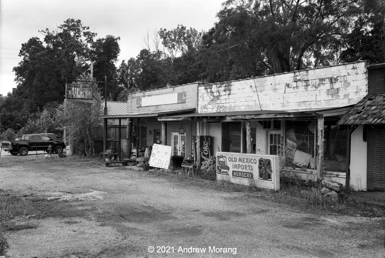
Smith's Appliances, Magnolia Road (35mm ƒ/2.0 Summicron-M lens)

Smith's Appliances is full of interesting automobile and filling station memorabilia. Thank you Mr. Smith for generously letting me take pictures inside. This was a 1-sec exposure with the Leica camera placed on a shelf.

Bamboo grove, Confederate Avenue, Vicksburg National Military Park (50mm Summicron lens)
Bridge over Stouts Bayou, Letitia Street (Vito BL camera, 1/30 ƒ/5.6)
Collapsing church, Glass Road (Vito BL camera, 1/30 ƒ/11, yellow filter)

Edwards


Abandoned trailer, US 80 approx. 1 mile east of Edwards (35mm ƒ/2.0 Summicron-M lens) 
East of Edwards, US 80 is the frontage road just south of I-20. I do not know if this was the alignment of 80 originally or if the old road bed was subsumed by the interstate. West of Edwards, 80 is the original 1920s roadway.

Utica


Burks Gro, Utica (Vito BL camera)

Delta and Waverly, Louisiana


Silos off Levee Road south of Delta, Louisiana (50mm ƒ/2.0 Summicron-DR lens, orange filter)
Farm shed on LA 577 south of Waverly, Louisiana (Vito BL camera, 1 sec. ƒ/5.6)

Port Gibson and Yokena


Cottage on Ingleside Karnac Ferry Road, Port Gibson (Voigtländer Vito BL camera)
Alexander Road, Yokena (Voigtländer Vito BL camera)

The woods north of Port Gibson have some interesting old cottages and grungy trailers off the winding roads. I need to return to explore some more.

Avon


Abandoned farm, Riverside Road, Avon, Mississippi

Conclusions


This was a pleasant surprise! Amazingly, this Versapan still works and looks great. I love the tonality for my type of pictures. It shows that 50-year old black and white film that has been cool-stored can be used years after its expiration date. One roll of Versapan is left in my freezer - on hold for a future project.

These ancient Versapans were definitely more grainy than Fuji Acros or even contemporary Kodak Tri-X. Versapan looks like an old-school mid-speed film, like Plus-X. Well, no wonder, it is 50 years old. It gave many of my pictures a gritty press photography look, which I like for urban decay. Looking at the original TIFF files carefully, I can see many tiny white spots in the negatives. I think they are not bubbles from development but rather deterioration of the emulsion. Resized at 1600 pixels to show here on the web, the spots are invisible. 

It is fun to experiment with old films, but you need some assurance on how they were stored. 

The next article will be on Kodak Panatomic-X film in 135 size.  

Appendix


Please click the link for the data sheet that came with the GAF Versapan film. They list the film speed as ASA 125/22 DIN. Unfortunately, it does not provide any development times for contemporary film developers.