Friday, July 12, 2019

Quick drive on North Washington Street, Vicksburg, Mississippi

Washington Street view north. Undated, from Cooper Postcard Collection, Mississippi Department of Archives and History
Washington Street: a distinguished name that honors our first president. Almost every city or town in the USA has a Washington Street, and Vicksburg is no exception. North Washington Street extends from approximately Grove Street to the junction with US 61 Bypass, a few miles south of the community of Redwood. At one time, US 61 ran through downtown Vicksburg along Washington Street, but the bypass was built in the 1970s to let heavy truck traffic avoid driving through downtown. We will take a quick look at N. Washington Street starting at Grove Street and move north.
North Washington Street from 61 Coffeehouse, Fuji Acros 100 film, Vito BL camera
Before our short exploration, a stop at the 61 Coffeehouse at 1101 Washington Street yields an excellent espresso and conversation with the barista ladies. The block just north of Grove Street (see the field in the photograph above) has been bare since before 1985. It probably fell prey to the "urban renewal" plague that hit Vicksburg in the 1970s.
Warehouse, corner of 1st East and N. Washington Street, Tri-X film
Some nondescript warehouses are at the corner of N. Washington Street and 1st East. From here north, Washington Street is reasonably flat and easy for bike riding.
Jo-Anna Motel, from the Cooper Postcard Collection, Mississippi Department of Archives and History
The Jo-Anna Motel (click the link to my 2011 article) was near the intersection where Haining Road turns off to the Port of Vicksburg. The Jo-Anna was torn down in the 2000s when the National Park Service bought the land. The land today is untended and a mess of weeds, mud, and scrubby trees.
Vicksburg Forest Products from Haining Road bridge over railroad, Vito BL camera, Acros 100 film, polarizing filter
The first big business that is visible from Washington Street is Vicksburg Forest Products (formerly Anderson-Tully Company). The tracks in the foreground continue as far north as the International Paper mill north of Redwood.
Corner of Hutson and N. Washington Streets, Olympus Trip 35, TMax 100 film, yellow filter
3112 N. Washington Street, Olympus Trip 35, TMax 100 film, yellow filter
3950 N. Washington Street, Olympus Trip 35, TMax 100 film, yellow filter
Heading north from Haining Road (Port of Vicksburg), you pass small cottages, mobile homes, and churches.
Former detail shop at corner of Chicasaw Road (digital file)
Exact location unknown, N. Washington Street, Kodachrome film
This sign describing the Chicasaw Bayou battle has been moved, so I am not sure where I took this photograph. I have looked for the Corvair junk yard, but never found any remnants. The houses near the present sign are different.
Spouts Spring Road, Vicksburg, Hasselblad, 80mm Planar lens, expired Kodak Ektar 25 film
Cottages on Spouts Spring Road, Olympus Trip 35, TMax 100 film, yellow filter
Spouts Spring Road is a U-shaped road that runs east of N. Washington Street. There is a spring that has been channeled into a creek. I wonder if the water is drinkable and could be used rather than wasted? I sometimes ride here to avoid some of the truck traffic on the main road.
Margaret's Gro in 1985, 4535 N. Washington Street, Kodachrome 25 slide, Pentax Spotmatic, 28mm lens
Margaret's Gro & Market was a small market in the early 1980s. Then Reverend Dennis married Margaret and started to convert the grocery into his Temple to the Lord. Through the early 2000s, it was an amazing and unique example of folk art with vibrant paint and hand-made sculpture.
Margaret's Gro, Fuji Reala film, converted to black and white.
Reverend Dennis learned about brick work from German prisoners of war in World War II. His visitor book had signatures from hundreds of German tourists. The photographer, Suzi Altman, has many pictures of Margaret's Gro on her site. I have also written about it before (type Margaret's Gro in the search box).
Road from sand quarry, Rolleiflex 3.5E camera, Kodak Panatomic-X film
A sand or gravel quarry is east of N. Washington street, just a short distance south of the intersection with the 4-lane 61 Bypass. I recently noticed that a couple of old farm houses had been demolished (visible to the left in the picture above).

This ends out short ride down North Washington Street. Thank you for reading.

Sunday, July 7, 2019

Small towns in Mississippi: Utica (B&W film)

Gasoline station, White Oak Street, Utica (Kodak BW400CN film, Leica IIIC camera, Canon 50mm ƒ/1.4 lens)
Utica is a small town southwest of Jackson, Mississippi. Many people bypass it while driving on Highway 27 as they go from Vicksburg to Interstate 55 near Crystal Spring. Utica has fallen on hard times. My friends, who grew up there, told me that a clothing factory formerly sewed Izod sports clothing, but when the factory closed, the town's economy largely collapsed.

I passed through Utica a few weeks ago and stopped to take some pictures with a new (to me) 1960s 50mm ƒ/1.4 Canon lens.
Bible Barn, West Oak Drive, Utica
I am not sure what Bible Barn once sold, but it looked closed.
Main Street was once lined with turn of the (previous) century shops and commercial buildings. Some of these featured cast iron fronts that supported the weight of the upper facades and roofs while allowing large plate glass windows to display merchandise inside. Top grade construction over 100 years ago, in contrast to the crappy built-it-cheap structures that go up now.
Gas station, Hwy 27 and Ernie Martin Road, Utica
I came across another closed filling station at the corner of Highway MS 27 and Ernie Martin Road. Truck traffic regularly passes here, so I am surprised they were not profitable. A few miles west on Hwy 27, I photographed the Betigheimer Store many years ago. It has been gone for over 20 years.
Jack Road, Utica, Leica M2 camera (Leica M2 camera, 50mm f/2.0 Summicron-DR lens)
In 2018, I drove on Jack Road, which is really out of the way. I saw this interesting old house or possibly country store.

There may be more to explore in Utica. The old high school is still abandoned. I am not sure of the status of the unused Hinds County School.
The 2018 and 2019 photographs are from Kodak BW400CN film. This year, I was testing my new 1960s-vintage Canon 50mm ƒ/1.4 ltm (Leica Thread Mount) lens, and so far, it is fantastic. What beautiful, traditional craftsmanship.

Tuesday, July 2, 2019

The Mississippi Delta 31: the Onward Country Store, Onward

Onward Country Store, September 1996 (4×5" Tri-X film, Tachihara camera, 75mm ƒ/8.0 Super-Angulon lens)
Onward is an unincorporated community in Sharkey County, Mississippi. The modest country store at the corner of US 61 (the Blues Highway) and Mississippi Highway 1 has been a fixture of the community since 1913. In its time, it sold various goods to farmers and travelers, provided quick lunches, and housed a post office. I previously wrote about the flooding in the area during the great flood of 2019.
Interior of Onward Store, September 1996 (75mm ƒ/8.0 Super-Angulon lens)
Mechanical bears, Onward Store, September 1996
I visited the store in 1996, and the proprietor generously let me take some 4×5" Tri-X frames with my wood field camera. The two mechanical bears would move on their pedestal. Some time after that, the store was burglarized and the antique electric bears stolen. It is amazing how low some people are. The bears commemorated the legend of the Teddy Bear, which was created by The Ideal Novelty and Toy Co. based on Teddy Roosevelt refusing to shoot a tied-up baby bear during a November, 1902, hunting trip.
Steiff Teddy Bear, approx. 1953 or 1954 vintage (Polaroid Sepia film, Tachihara 4×5" camera, 180mm Caltar IIN lens)
This is my Steiff bear. He traveled from Greece to Burma to Ceylon and destinations in between, ending up in Vicksburg. Oddly, no one in the family told me the story about Teddy Roosevelt.
Onward Store, October 2002 (Kodachrome 25 slide, Nikon F3, 35mm ƒ/2.8 PC-Nikkor lens)
Onward Store, October 2002 (Kodachrome 25)
It was difficult to photograph the store because an ugly modern canopy over the gasoline pumps obscured the front unless you were way off to the side. The two Kodachrome color photographs above are from 2002. It was not possible then to take a straight-on view
Onward Store front porch, March 2019
Onward Store, March 29, 2019 (Fuji Acros 100 film, Voigtländer Vito BL camera, 50mm ƒ/3.5 Color-Skopar lens, 1 sec. exposure)
Onward Store, March 29, 2019
I checked in at the Onward Store in March of 2019 when I was exploring the flood in the southern Delta. The ugly steel canopy was gone, cleaning up the appearance of the front. The store had been largely converted into a restaurant, and it looked like business was brisk. I chatted with some British tourists who were on a Blues exploration. I took two pictures inside.

My friends and I ate at the Onward Store on April 11. The catfish was excellent. Then in about a week, an announcement on Facebook stated that the Onward Store had closed. I do not know the story. We must have been among the last customers. I hope someone can purchase the old store and continue the tradition of southern cuisine.
Farm house, Onward (Fuji Acros 100 film, Voigtländer Vito BL camera, 50mm ƒ/3.5 Color-Skopar lens)
There are not many houses near the store. This cottage on the east side of US 61 was closed and unoccupied. The vines and jungle are taking over.

Friday, June 28, 2019

The Mississippi Delta 30: Lee's Cotton Picker Art Gallery, Rolling Fork, Mississippi

Lee's Cotton Picker Art Gallery, Rolling Fork, Mississippi (Fuji Acros film, Voigtländer Vito BL camera, 50mm f/3.5 Color-Skopar lens). Click any picture to expand to 1600 pixels wide.

Rolling Fork is a typical Mississippi Delta agricultural town only about an hour north of Vicksburg. I had not been to downtown Rolling Fork in several years and was surprised to see a new art gallery on Walnut Street.
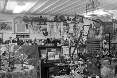
I stopped and met Mr. Lee Washington, a friendly gent who was doing some welding in his shop. He uses the spindles from cotton harvesting machines as well as other metal bits for his art. Mr. Washington graciously let me take some photographs.


The porch is a wealth of neat stuff, bottle trees, and contraptions.


The inside of the gallery is especially interesting. My Vito BL camera has a fixed 50mm lens, so there was no way to capture the entire scene in one frame. These are 1 second exposures with the camera mounted on a tripod.


Across the street: a Highway 61 mural on the side of the Sharkey-Issaquena Library. Well done!!

All photographs are from Fuji Acros 100 black and white film, exposed with my 1957-vintage Voigtländer Vito BL camera with a 50mm ƒ/3.5 Color-Skopar lens. This is an impressive unit-focussing 4-element Tessar-type lens. As you can see in frame 3 above, there is only the slightest amount of flare or blooming around the fluorescent lamps. The lens is coated with a blue-purple coating. If you are interested in details, I wrote about this camera on the 35MMC blog.
Saturday, June 22, 2019

The Flood of 2019 (Part 3), the Yazoo Backwater near Onward and Yazoo City, Mississippi

We will continue our review of the flooding in the southern part of the Mississippi Delta, the area known as the Yazoo Backwater. The last article was about the area near the town of Redwood. Here we continue north a few miles to Onward and briefly jump east to Yazoo City.

Onward is an unincorporated farming community near US 61 south of Rolling Fork. Onward is known for two historical notes:
  1. This is near the site where president Teddy Roosevelt refused to shoot a baby bear that had been tied to a tree as a target for the president. A toy company picked up on the refusal to shoot, started making stuffed bears, and the rest is history - one of the most successful children's toys ever. It became an international toy, as well; my Steiff bear was from Germany.
  2. The Onward Country Store has been in business since 1913. It is (or was) a popular stop with European tourists who travel on US 61, the Blues Highway. But there is bad news: the Onward store may have closed as of April 2019, according to an article in The Vicksburg Daily News. I will write about the Onward Store soon. 
Onward Store, 1996, before removal of gasoline pump canopy (4×5" Tri-X film, 75mm ƒ/8 Supar-Angulon lens)
This is the front of the Onward Store as of 1996. The store faces US 61 (the Blues Highway) and is just south of the intersection with Rte 1. Residents of Eagle Lake need to drive on Rte 1, then turn south on 465 and access the mainline levee. The levee road eventually gets them to Eagle Lake.
Farm north of Rte 1, April 11, 2019 (Panatomic-X film, Fuji GW690II camera, yellow filter)
Farm fields north of Rte 1 near 465 junction, March 29, 2019 (Ektar 25 film, Hasselblad 501CM, 250mm Sonnar lens)
Some of the fields north of Rte 1 were semi-dry, but heading west and closer to the mainline levees, the road dipped down, and the surrounding fields were inundated.
Flooded woods, Hwy 465, March 29, 2019 (Fuji Acros film, Vito BL camera, 50mm ƒ/3.5 Color-Skopar lens, GGr filter)
Flooded woods, Rte 1 near levee, April 11, 2019 (Panatomic-X film, Fuji GW690II camera, 90mm lens, ½ sec ƒ/16½) 
Rte 465 takes off south from Rte 1. The day I drove on it, a short section was underwater, but people were driving through, so I did the same carefully. The road runs through forest, much of which was flooded. What struck me was the number of snakes. I saw numerous ones that were squashed and hit at least one when it slithered across the road just in time for my tires. It appears that they cross from the woods on one side of the highway to the other. Most looked like black water moccasins, but one nicely patterned fellow sitting quietly in the middle of the pavement looked like a rattlesnake. (I decided to not get out and check in person.)
Unoccupied house, US 61, Onward (Fuji acros film, Vito BL camera, GGr filter, 1/30 sec ƒ/11½) 
Back in Onward, the fields just east of 61 were dry. I saw this unused mid-century house slowly being engulfed with vines.
Dusk at Egremont, view west, March 29, 2019 (Vito BL camera, 50mm Color-Skopar lens, GGr filter) 
Egremont is a small community south of Rolling Fork. I have more Egremont photographs to share in the future.
Hwy 16 west of Yazoo City, March 13, 2019 (Ektar 25, Hasselblad 501CM, 250mm Sonnar lens)
To the east, Yazoo City (the "Gateway to the Delta") sits on the edge of the loess bluffs. But to the west lies the flat Mississippi Delta and the Yazoo River. The fields along Hwy 16 were inundated as of mid-March when I took these pictures with my Hasselblad camera.

This concludes a short look at the flooding in the Yazoo Backwater. As of mid-June, much of this area is still under water. Depending on water conditions, I may do some more exploring and photographing.

Click the link for Part 1 of this series.
Click the link for Part 2 of this series.

Saturday, June 15, 2019

The Flood of 2019 (Part 2), the Yazoo Backwater near Redwood, Mississippi

This is Part 2 of our article about the 2019 flood in west central Mississippi. In the previous article, we covered the inundation in the area around Vicksburg, which is directly affected by the level of the Mississippi and Yazoo Rivers. Here we will look at the flooding that occurred north of the Steele Bayou flood gates.
Yazoo Backwater (from NOAA)
The Yazoo Backwater is the area of the Mississippi Delta that is north of the Steele Bayou floodgate. As I wrote in the previous article, if heavy rail has fallen in west central Mississippi, the water heads south through creeks and bayous, eventually into the Yazoo River and then to the Mississippi River. But levees line the Yazoo River, and if the Mississippi River elevation is high, the US Army Corps of Engineers closes the Steele Bayou gates and the local drainage has no way to escape into the Yazoo River. The result is varying degree of inundation in the area shown in gray on the map.
MS route 465 just west of US 61, Redwood, Mississippi, March 13, 2019 (Kodak Ektar 25 film, 250mm Sonnar lens)
Eagle lake is an oxbow lake in the southern part of the Yazoo Backwater. It is the blue crescent at the lower left in the gray area. The residents were told to evacuate in January. But many decided to stay in their homes and tried to hold back water with sandbags. One of my friends lives there and said convicts were brought in to help with sandbagging. She cooked meals for all the workers.
Hunting camp on stilts off US 61 near MS 465 turnoff, March 14, 2019 (50mm Distagon lens)
In March, this elevated mobile home was visible from a dirt road, but now the foliage is too thick.
Hendricks Lane off Floweree Road, March 14, 2019 (80mm Planar lens)
Farm shed, Perry Circle off Floweree Road, Redwood (photograph from former railroad embankment, 80mm Planar lens)
Morning Star MB Church, Floweree Road (80mm Planar lens, polarizer)
Tree trunk, Floweree Road, March 15, 2019 (80mm Planar lens, polarizer)
Floweree Road is a U-shaped road that takes off from US 61 just north of the turnoff for MS 465. It was an interesting road to bicycle in January because of the water all around. We saw a dead boar being eaten by vultures. Presently (June 6, 2019) Floweree Road is completely inundated and impassible by cars. All the scenes above are at least 1-2 ft deeper in the water now. The railroad once ran near Floweree Road, and many farmers parked farm equipment up on the embankment.
House and flooded car, US 61, Redwood, March 29, 2019 (Fuji Acros 100 film, Voigtländer Vito BL camera, 50mm f/3.5 Color-Skopar lens, yellow filter)
Inundated house, US 61, Redwood, March 29, 2019 (Acros film, Vito BL, GGr filter)
Mobile home and almost-safe vehicles, US 61, Redwood, March 29, 2019 (Acros film, Vito BL, GGr filter)
Cars parked along US 61 for safety, near Floweree Road, Redwood (Acros film, Vito BL camera)
Farm off US 61 near Floweree Road, Rdwood (Acros film, Vito BL, yellow filter)
This has been a quick look at the scene off US 61 (the Blues Highway) near Redwood, Mississippi. I will continue this 2019 flood topic the next article.