Showing posts sorted by date for query Sonnar. Sort by relevance Show all posts

Saturday, February 25, 2023

Vicksburg with a Hasselblad 100mm ƒ/3.5 CSi Lens and Fuji Pro 160 NS Film (Abandoned Films 10)

After successfully completing some medical treatments, I was overcome with a serious bout of GAS. That is Gear Acquisition Syndrome, although the other gas was also present. 


Hasselblad 501CM with 100mm ƒ/3.5 Planar CSi lens and correct hood

For over five years, I used an 80mm Planar lens on my Hasselblad. But sometimes, I wanted just a bit more reach. With 35mm cameras, I liked the 55mm ƒ/1.8 Super-Takumar lens on the Pentax Spotmatic. This was just marginally longer than the more common 50mm. Hasselblad's 100mm Planar lens would provide a diagonal coverage on 6×6 approximately equal to 55mm on 35mm, so I started looking at online vendors in USA. Soon, this gorgeous 100mm ƒ/3.5 Planar CSi lens came in a big padded box from Camera West. This is a 6-element Planar design and is reputed to be the highest resolution Hasselblad lens for distant subjects.

On a foggy and drizzly January day (my favorite light), I loaded a roll of Fuji Pro 160 NS film in the holder and headed out. This is a neutral color balanced film designed for wedding, fashion, and commercial product photography. Fuji did not distribute 160NS in the USA and discontinued it in the Japan market in October 2021.  

I posted these frames at 2400 pixels wide, so click any picture to see the details. Most were tripod-mounted.


Polk Street view east, January 7, 2023, 1/15 ƒ/11
Monroe Street looking south from China Street. The former Junius Ward YMCA is to the right.
Pearl Street near Fairground Street, 1/15 ƒ/16
2521 Pearl Street, still occupied (taken from railroad tracks)
501-509 Fairground Street (taken from railroad bridge), 1/15 ƒ/16
Floodwall and Bunge Corporation, Levee Street, view south (hand-held)
1109 Mulberry Street, view east, 1/30 ƒ/11

LD's Restaurant is in a building that formerly housed a club/bar (closed several times because of shootings) and a liquor store.


Railroad yard from Levee Street - 250mm ƒ/5.6 Sonnar lens, 1/4 ƒ/22
2427 Washington Street - 80mm ƒ/2.8 Planar-CB lens

I added two frames that I took with my 80mm and 250mm lenses. Hasselblad's 100mm lens is considered to be their "sharpest" (whatever that means in internet fantasy-land), but all the Zeiss lenses are superb performers. My Planar-CB is a 6-element design, in contrast to the more common 7-element models. My 250mm Sonnar is a 1960s silver barrel model with single coating, but it is just fine.


I found a very handy padded bag to hold my camera on the car seat next to me or on the floor. The rest of the kit stays in a larger camera bag. This is a Ruggard Onyx 35, only $17.95 from B&H. $17.95? That is the cost of a roll of film now. The original idea came from a WalMart lunch box that my wife suggested, but this Onyx is well-sewn and protective. Highly recommended.

Thank you all for joining me on this semi-random tour of Vicksburg.


Thursday, January 6, 2022

Afternoon at Logan (Boston, Massachusetts)

Dear Urban Decay readers, Happy New Year! Let us all hope that 2022 is a better year all around than 2021, which was pretty horrible for many people. At least the US stock market was happy, but that does not help millions of Americans. Maybe the pandemic will wane in the coming year and we can sort-of return to normal travel and mixing unsocial gatherings. 

In the meantime, here are some photographs from my archives of Boston and Logan Airport.
_______________________________________________________________________________

Panorama of Boston and Logan Airport from Hilton Hotel, May, 1988. (4 Kodachrome frames from a Rollei 35S camera; click to enlarge and see details)

I have flown in and out of Logan Airport too many times to remember, starting sometime in the 1950s. 

The US Army built the original landing field, then named Boston Airport, in 1923 on tidal flats in East Boston. The fill at that time consisted of cinders, meaning coal clinkers. Many of the 1800s fills in and around Boston were a convenient way to dispose of clinkers. The term then used was reclamation, as if humans were "reclaiming" land from the sea. I remember during the 1973 oil crisis, some people suggested burning coal at home as a source of heat. My uncle, an old-timer, told me that was an absurd idea. Where would we take the ash and clinkers? He was right; it would be difficult to dispose of the coal waste for a city the size of Boston and its suburbs. 

The Army operated Boston Airport until 1928, when they transferred it to the State of Massachusetts. As the years progressed, the state added more landfill, expanded runways, and built terminals. The field was renamed the General Edward Lawrence Logan International Airport (IATA: BOS). Today, Logan is a bustling transport hub, the 16th busiest airport in the USA, with many daily international flights.

Typical 1988 afternoon on the Southeast Expressway, waiting to transit to the Callahan Tunnel and to Logan Airport

Logan is also a topographic confusion (OK, total mess) of twisting roads, buildings seemingly perched haphazardly all over the place, one-way streets, and choked traffic. It is often a nightmare getting in an out of Logan, especially by car. Decades ago, the State should have purchased another location for their main airport, a site inland that was not as constrained by water and had easier access. 

The photograph above shows a typical afternoon on the old (now demolished) Southeast Expressway en route to Logan Airport. The Southeast Expressway was one of the grandiose 1950s projects to build high speed roadways through American cities, regardless of the environmental and societal cost. Opened in 1959, it was instantly hated because it partly cut off the Italian North End from the rest of the city. As you recall, these highways often cut through low-income neighborhoods (usually meaning African-American) as if the continuity of their neighborhoods was of no value. Also, those people usually did not have the access to high-power lawyers or political friends to argue their situation. But this sordid topic of corruption and giveaways to the construction industry is for a future blog article. 


In 1988, I attended a training class in Cambridge and stayed a few nights at the Hilton Hotel at Logan Airport. Surprisingly, my room had an interesting view west towards downtown Boston (see the panorama) and overlooking some of the Logan hangars. Not bad for an airport hotel. This older building has been replaced by a modern and larger Hilton. In 1988, some operators still used propellor planes. Eastern Airlines was still operating, before being absorbed into PanAm and thereafter disappearing into bankruptcy oblivion.

In the photograph with the Eastern Airlines hangar, the long building across the water is the former Army Supply Base, also known as the Boston Quartermaster Terminal. In the late 1930, my father worked for the US Army Corps of Engineers in that building. 

These are Kodachrome slides from a Rollei 35S compact camera with a 40mm ƒ/2.8 Sonnar lens. I scanned the slides with a Plustek 7600i scanner and created the panoramas with Photoshop CS6. 

UPDATE. (Extra information in response to a comment left by Jim Grey below.) 

Issue 1: The MBTA Blue Line stops at Airport (appropriate name). The problem with this stop is that it is too far from the terminals for most people to walk. Therefore, a surface bus runs on a loop to the terminals, car rental center, and Airport station. Decades ago, the bus cost 25 cents, cash only. I always wondered, a tourist steps off the plane from Paris or Lagos and he is supposed to have 25 cent coins ready to drop into the coin box? At least now, the bus no longer requires a fee. 

Issue 2: In almost every European city that I have visited, plus Bangkok and Hong Kong, the train comes literally under the terminal. Go through passport control, pick up your bags, and take the escalator down to the train station. No need to fight snow or rain with your luggage. In 60 years, the MBTA has not been able to reroute the Blue line into a subterranean station the would be convenient for passengers? Seriously? And Boston likes to think it has a world-class airport?

Issue 3: In Airport station, you use a vending machine to buy a transit pass for one ride or various time periods. OK, that is easy. But a sign states that there is a reduced fare for senior citizens. However, this fare machine will only refill or validate an existing senior pass. You need to acquire the senior card downtown at another station. Seriously?

Thursday, December 16, 2021

Wandering around Upper Clay Street, Vicksburg, Mississippi

Clay Street view west (Panatomic-X film, Hasselblad 250mm Sonnar lens, 1/15 ƒ/8.0½)

Clay Street is the major east-west road through Vicksburg. Before Interstate 20 (I-20) was completed in the early 1970s, US 80 came into town on Clay Street. A driver heading west would drive on Clay to downtown, turn left on Washington Street, and drive south to the old Mississippi River bridge.

I label the part of Clay Street just west of the Vicksburg National Military Park as upper Clay, while the area downtown near the Yazoo Canal is lower Clay. Here we will look at some scenes in upper Clay. Decades ago, private homes lined the street, but now it is strip America of the ugliest sort. You car, tire, and muffler repair shops, check-cashing and title-loan places, a few real estate offices, abandoned buildings, a dead A&P super market, derelict historic homes, and fast food emporiums. Empty lots show where houses once stood. A former resident labeled this "the ugliest street in America." Well, maybe not the ugliest, but certainly a contender. 


The Eastview Apartments, situated between Clay Street and Baldwin Ferry Road, are low income housing subsidized by the federal government via HUD (Housing and Urban Development). They are unusual construction, being suspended between telephone poles that were driven into the ground on the steep hillside. It was a practical solution compared to grading flat terraces and pouring concrete slabs. 

Eastview Apartments with Stouts Bayou in foreground (Panatomic-X film, Hasselblad, 50mm ƒ/4 Distagon lens, green filter)

Stouts Bayou flows under Clay Street through some form of culvert or tunnel because it emerges out of the hillside below the Eastview Apartments. This is kudzu jungle. It needs a cleanup by goats.


Warfield's ServiceCenter, at 2910½ Clay Street, has served customers for over 30 years. Good people.
 

One of the nondescript street running into Clay Street from the north is Hope Street. The proprietor at A & V Discount Tobacco & Beer generously let me take a photograph.


The long-unused Parkview Regional Medical Center building looms over the area north of Clay Street. It has been vacant since 2002, except for homeless who occasionally find ways to enter.

Mercy Hospital, Grove St. (Kodak Super-XX film, Tachihara 4×5" camera, 90mm ƒ/6.8 Angulon lens)

The Sisters of Mercy, who have a long history of care in this town, originally built Mercy Hospital in 1957. The present owners have tried to sell it but with no results. Who wants an obsolete hospital building considering the cost to renovate and upgrade electricity, exits, stairwells, and utilities? Externally, it looks intact, but I do not have information on the roof or the interior. 

When I took photographs in the parking lot in the rear, the neighbors came by and said they watch for vagrants. The police come, clear away the homeless, and then they return later.


Further west is a short segment of Crawford Street. This is not the main Crawford Street downtown but a short detached section running directly next to Stouts Bayou. The houses are on the south side of the road and have access via wood bridges. I photographed more of the Crawford Street region during my tour of neglected Vicksburg houses (Nov. 16, 2020 article).

1517 Main Street (Panatomic-X film, Hasselblad 501CM camera, 80mm lens, 1/8 sec. ƒ/8.0½)

Main Street is one of Vicksburg's historic streets. It is still lined with old houses, but one by one, they have been condemned and demolished. This house at 1517 looks pretty good, and I do not know its issues.

This ends our short tour of upper Clay Street. Standby for more Vicksburg photographs soon. Thank you all for riding along.

Thursday, July 1, 2021

Optical Treasure: 1960s Jupiter-8 Lens from the Soviet Union

This will be a short review of my new/old Jupiter-8 50mm ƒ/2 lens from the Soviet Union. It was made for use on Soviet thread-mount cameras, like the FED, but uses almost the same 39mm thread as the original Leica bodies as well as most Japanese post-war rangefinder cameras.


Jupiter-8 lens mounted on my 1949-vintage Leica IIIC camera
Coated front element of Jupiter-8, probably 1962 construction (note: scratch-free and clear)


Many film photographers love the rendition from the classic Zeiss Sonnar 50mm ƒ/2 lens. Dr. Ludwig Bertele at Zeiss Ikon, the German optical giant, first formulated this lens in 1929. The name comes from the word “Sonne,” meaning Sun. Zeiss sold it with their magnificent Contax rangefinder camera in the 1930s and later. This competed with Ernst Leitz's popular Leica thread-mount cameras when equipped with their 5cm ƒ/2 Summar lens or the later 7-element ƒ/2 Summitar lens. 

After WWII, the Soviets packed up and moved remnants of the Zeiss factories, tools, machinery, glass, and technicians to the Soviet Union and painfully began to rebuild their home optical industry. They largely copied the Zeiss optical designs but made minor changes over the years and coated the glass surfaces to reduce flare. They renamed these new lenses Jupiter (ЮПИТЕР). The 50mm ƒ/2 version is the ЮПИТЕР-8. They produced these lenses from the early 1950s until about 1991, when the Soviet economy collapsed. The Jupiter-8 was the standard lens on many Zorki, FED, and Kiev cameras, which were made in the millions. The Soviet lenses had aluminum mounts instead of the superior brass/chrome mounts of the older German production. The Internet is full of detailed reviews of the Jupiter-8, so I will not repeat the same material. 

Recently, the Lomo company reintroduced the Jupiter-3, which is the 50mm ƒ/1.5 model. Note that Zeiss still sells a modern ƒ/1.5 Sonnar lens, an amazing testament to a long-lasting design (but the current lens is significantly different then the original).

Eighty years after the original design, photographers still like the way the Sonnar reveals details on film. Original 1930s and 1940s German examples are seriously expensive. As an alternative, I decided to try a Jupiter-8 and found one from a seller from Arizona. He said he bought it decades ago along with a set of Soviet thread-mount cameras. Arizona - that suggests dry and no fungus. This one was a Version 2 (design PT3060) from 1962 production (earlier is better for Soviet optics). The lens was clean and the coating almost perfect, but it was need of re-lubricating, as do almost all of these old Soviet optics; after all, they are 50+ years old. 

This lens uses a filter mount thread of 40.5mm. This was common for German lenses in the post-war era. I already had a 40.5mm Series VI filter adapter, allowing me to use my Series VI filters. Note that some Japanese lens makers used a filter diameter of 40.0mm for their ƒ/2 or ƒ/2.8 rangefinder lenses. Why did they do that? Was it to sell brand new filters and accessories to buyers of Japanese lenses? Yes, of course!

Here are some Jupiter examples around town, both when mounted on a digital camera and when used with film on my Leica IIIC camera.

Digital


I attached the Jupiter-8 to my Fuji X-E1 digital camera using a Leica thread mount-Fuji-X adapter. On all of these scenes, I set the Jupiter at ƒ/5.6 and mounted the camera on a tripod to eliminate vibration. This digital camera has an APS-size sensor, so a 50mm lens provides a field of view similar to a 75mm lens on a 35mm camera. Click any frame to expand to 1600 pixels wide.

 
Approaching storm, Kansas City Southern rail yard, Levee Street, Vicksburg (ƒ/5.6)
After the storm, Levee Street, Vicksburg
Kansas City Southern rail yard from the Yazoo Canal levee, ƒ/5.6
Washington Street view north
Pine Street cottages photographed from Belmont Street
Work shed on Yazoo Canal levee (no longer extent)

Panatomic-X Film 


I loaded Kodak Panatomic-X film in my Leica IIIC. I thought it appropriate to expose an old-fashioned film in an old camera body mounting an old lens. The package proved to be compact and convenient to use, but I do wish the Jupiter had click-stops on the aperture control. I exposed the Panatomic-X at EI=20, so most photographs required a tripod. I used a Gossen Luna Pro Digital light meter in incident mode for most measurements.

Sondheimer, Louisiana (1/10 ƒ/11.5, medium yellow filter, tripod-mounted)
1101 N. Chestnut Street, Tallulah, Louisiana (1/10 ƒ/8.0)
PoBoy Don's, LA 602 east of Tallulah, Louisiana (1/100 ƒ/4.0, hand-held)
Footbridge from Avenue B over Stouts Bayou, Vicksburg, Feb. 15, 2021 (1/10 ƒ/11.5)
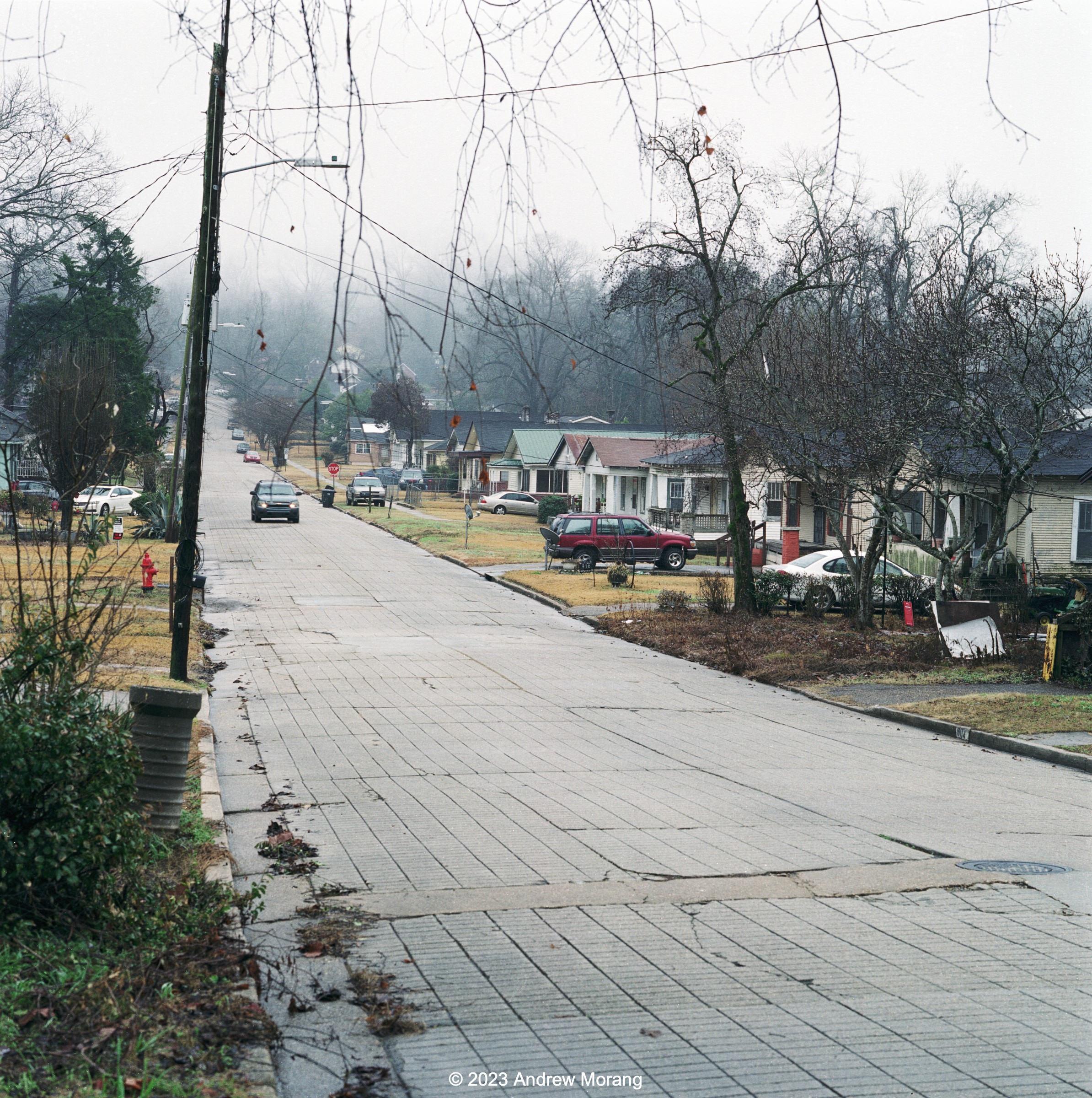
Acadia Place, Vicksburg, Feb. 15, 2021
Kansas City Southern rail tracks at Maloney Circle, Vicksburg National Military Park (1 sec. ƒ/16)
Fairground Street Bridge (¼ sec ƒ8; click to see 2400 pixels)

Fuji Acros 100 Film


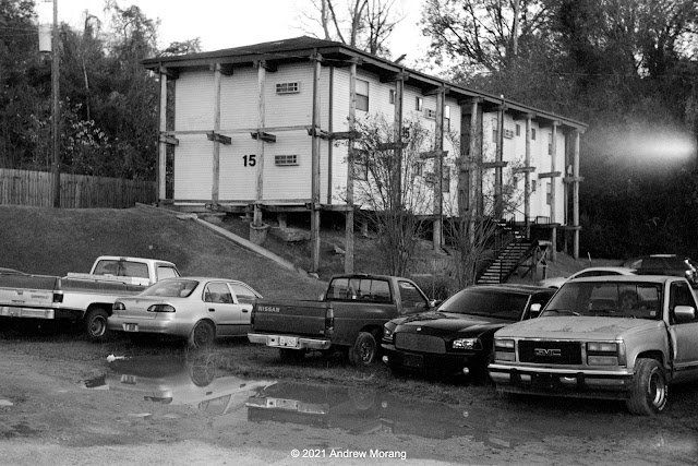
Old bus, Moseley Gap Road, Vicksburg (¼ sec. ƒ/16)
Ford Fairlane, Mt. Alban Road, Vicksburg (1/10 sec. ƒ/11.5)

I also finished a roll of Fuji's superb Acros 100 film with the Jupiter-8 lens. Being an ISO 100 film, it is easier to use out in the field than the slow Panatomic-X film (but the examples above are tripod-mounted). 

Kodak BW400CN Film


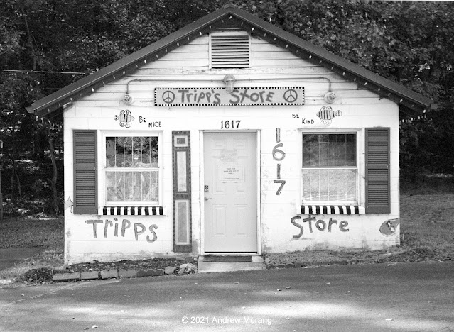
Tripp's Store, Mount Carmel Road, Chapel Hill, North Carolina
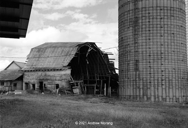
Barn off Greensboro-Chapel Hill Road, Snow Camp, North Carolina (1/100 ƒ/11.5, yellow filter)
Greensboro-Chapel Hill Road, near Snow Camp, North Carolina

I have mixed feelings about Kodak BW400CN film. For these scenes, it worked well. At other times, it looks grainy and gritty. Possibly it does not age well. Regardless, I have used up my last three rolls and will not search for any more.

Comments and Summary

 
This old Jupiter-8 is a nice lens, and I like the results on both a digital camera and on black and white film. I think it sings with film. I do not see any obvious barrel or pincushion distortion, and exposure is even across the frame. At apertures wider than ƒ/5.6, this lens is quite weak, and sharpness falls off at the corners. On the scale of web pictures, the falloff is barely visible. I do not see (or do not know what to look for) the unique Sonnar rendition in these examples, but my photography friend in the UK said the special magic is at ƒ/2. This Jupiter has less field curvature then my 1949 Leitz Summitar lens. 

The Jupiter has an aluminum body, which is conveniently light weight. The finish is not up to German or Japanese standards, but at least on my sample, the numbers are perfectly legible. No issues.

Many photographers have written about focus shift with Sonnar lenses. I have not seen it yet, but have not taken close-focus photographs at wide aperture. This lens and my Summitar both focus perfectly at infinity using the same Leica-Fuji X adapter on my Fuji X-E1. Therefore, I assume that the Jupiter-8 is correctly adjusted for infinity on a Leica thread-mount camera. Close-up, it may back focus a bit, but I will need to test some more (one day in my non-spare time). UPDATE: I sent it to Mr Brian Sweeney, a Soviet lens expert in the USA, for a cleaning and adjustment for correct focus on Leica cameras.
 
I have also used one of the superb 1960s Canon 50mm ƒ/1.4 lenses. The Canon was more uniform across the field and may have displayed marginally better resolution. The mechanical construction was much better, typical Japanese excellence and precision from the 1960s. Its downside for me was the size of the overall optic. It blocked too much of my viewfinder of my little Leica, and the auxiliary 50mm finder was clumsy. 
 
In summary, the Jupiter-8 lens works well and has a nice rendition on film and digital. It is conveniently compact. When I use my little IIIC camera, I just may end up taking both the Jupiter and Summitar 50mm lenses in my camera kit.


Tuesday, April 27, 2021

Tracing Vicksburg's Rail Line South

Introduction


Most Vicksburg residents are familiar with the convoluted route that the Kansas City Southern freight trains take through town. Trains cross the old Mississippi River Bridge, turn north, and either go to the rail yard at Levee Street or ascend parallel to Pearl Street and then turn inland to head towards Jackson. However, there is also a southern extension that now gets little use. At one time, the tracks ran as far south as Eaton Lighting off US 61 south (near the municipal airport), and trains would have served Eaton, the now-defunct Mississippi Chemical Company, and other industries. 

The history of rail in this area is complicated, and I can't begin to understand it. In the late 1800s, several companies extended tracks almost as far south as the Big Black River. In 1883, the Louisville New Orleans & Texas Railroad absorbed existing track and rebuilt it to standard gauge to use for part of their Memphis-Vicksburg-Baton Rouge-New Orleans main line. I do not know when this service ended, but today, no track extends south of approximately Magnolia Road (near Rainbow Farms). No tracks have run to Port Gibson in many decades.

I have shown pictures of the Kansas City Rail yard at Levee Street before. My articles in Trackside Photographer or here at Urban Decay trace the main KCS line through Vicksburg. Here I will trace the lesser-used track that runs to the south starting at the Frontage Road (north of I-20). Access is limited; maybe I should build one of those rail-bicycles that some people use to ride on defunct rail lines. Surprisingly, the Mapquest map still shows the rail line all the way south to Fayette, even though the tracks have been gone for decades. If you look at the map and then switch to the satellite view, you can often see vegetation or property boundary changes that mark the former rail embankment. 

Southern Route


Red circles mark locations of the following photographs proceeding north to south (from ESRI ArcGIS)
KCS tracks from Frontage Road (Fomapan 100 Classic film, Hasselblad 501CM camera, 80mm ƒ/2.8 Planar-CB lens)
This is where the southern line starts. The track at the lower right is the one we will follow in the following photographs. 
Frontage Road bridge (Tri-X film, Hasselblad 501CM camera, 80mm ƒ/2.8 Planar-CB lens, green filter)
The rail lines run on the opposite (west) side of Stouts Bayou. The bayou is just beyond the brush in the photograph above and the track is visible in the clearing.
Rail line passing under I-20 bridge (GAF Versapan film, Spotmatic II, 135mm ƒ/3.5 SMC Takumar lens, yellow-green filter)
Rail line next to Iowa Blvd. (GAF Versapan filmVoigtländer Vito BL camera)
Iowa Boulevard drops down from the Frontage Road near the Parkside Play House and passes under I-20. Many people take this road as a shortcut to Walmart. The track here also passes under I-20 and runs straight through woods with the next access at Rifle Range Road.
At Rifle Range Road, the track splits. One branch crosses a nasty creek and leads to Halcros Chemicals. The right track above continues south a short distance.
Halcros Chemicals, Rifle Range Road (Tri-X film, Hasselblad 80mm lens)
As this photograph shows, an occasional tank car is brought to Halcros Chemicals. These tracks once continued further south (beyond the sheds) and served the Mississippi Chemical Company. According to Google Maps aerial photographs, those tracks are gone. 

Mississippi Chemical operated from 1953 to 2002, when the parent company declared bankruptcy (according to The Vicksburg Post). Over the years, the company made pesticides, fertilizers, rocket fuel, nerve gas, and other industrial chemicals. Toxins and arsenic seeped into the ground, and part of the area needed to be cleaned as a Superfund site. How many rail cars carried rocket fuel or nerve gas on these tracks over the decades?
Wood bridge with Halcros Chemical beyond (Panatomic-X film, Spotmatic camera, 35mm Super-Takumar lens, fill flash)
Unused (abandoned?) timber rail cars (Panatomic-X film, Spotmatic camera, 55mm ƒ/1.8 Super-Takumar lens, yellow-green filter)
The other track (the one on the right side in the photograph above) only continues a few hundred meters south until you come across abandoned (or permanently parked?) timber railroad cars. They seem to continue indefinitely. What are they here? Are the wheels and steel not worth reusing?

Beyond the timber rail cars, the track continues almost to Warrenton Road, according to Google Maps. At Warrenton, the rails are gone, and the old bed under the bridge has grown in so much, you can't tell that track once ran there.
Former rail embankment at Willow Drive, view south (Tri-X film, Hasselblad camera, 250mm Sonnar lens, yellow-green filter)
Former rail embankment at Mop Lane, view north
Further south, the old embankment is being mowed by someone. Why? Will this right-of-way be used by some entity? 

Just north of the Vicksburg municipal airport, tracks once turned west into the Westinghouse (later Cooper and now Eaton) electrical equipment factory. A friend who started work at Westinghouse in 1976 said rail cars delivered heavy materials, like coils of copper, for about two years (until about 1968). Afterwards, trucks delivered all supplies and eventually Westinghouse removed the rails and changed the loading dock. 
Warrenton Lane (GAF Versapan film, Voigtländer Vito BL camera)
By the time you reach Warrenton Lane, near the Cedars Elementary School, the right-of-way is overgrown. You can see a bit of track disappearing into the brush.

A few miles south, only a short stub of track remains near the former Marathon Letourneau plant at Letourneau road. Further south, the terrain is wooded, and the railroad right-of-way is hidden or lost. But you can trace the former right-of-way on aerial photographs.

Port Gibson


Former rail line under Ingleside Karnac Ferry Road (GAF Versapan Film, Vito BL camera)
As I wrote above, decades ago, the rail line extended south to Port Gibson and then further to Baton Rouge. I was not sure if I could find any remnants of the old line, but while driving on Ingleside Karnac Ferry Road, I was surprised to cross a modern bridge over a distinctive V-shaped valley. A dirt road ran in this valley, but the large amount of gravel gave it away and the former rail line. The photograph above is from the bridge looking north.
Depot, Market Street, Port Gibson (GAF Versapan film, Vito BL camera)
The 1884-vintage Yazoo and Mississippi Valley Railroad depot is in Post Gibson at 1202 Market Street. It was converted into a restaurant in 1977 but is not in use now. Many of these railroad depot restaurants do not last long. Someone ambitiously renovates the buildings, but after a short burst of energy, the restaurant closes. A Mississippi Department of Archives and History Historic Sites Survey describes the depot. 

This has been our short excursion on the southern rail extension. Thank you for riding along.